Technical Memorandum
DATE: March 30, 2017
TO: Boston Region Metropolitan Planning Organization (MPO)
FROM: Chen-Yuan Wang
RE: FFY 2017 Addressing Safety, Mobility, and Access on Subregional Priority Roadways: Selection of Study Locations
During the MPO’s outreach for development of the Unified Planning Work Program (UPWP) and Long-Range Transportation Plan (LRTP), Metropolitan Area Planning Council (MAPC) subregional groups and other entities submit comments and identify transportation problems and issues that concern them. Often, these issues are related to bottlenecks, safety, or lack of safe or convenient access for abutters along roadway corridors. They can affect not only mobility and safety along a roadway and its side streets, but also a community’s quality of life, including economic development, and air quality.
To address these concerns, this study was included in the UPWP for federal fiscal year 20171 and a work program was approved on December 1, 2016. The purpose of this study is to identify roadway segments in the MPO region that are of concern to subregional groups but that have not been identified in the LRTP regional needs assessment.2
The study emphasizes issues identified by the relevant subregional groups, along with recommendations to address the identified issues. In addition to topics about mobility, safety, and access, it includes bicycle and pedestrian transportation, transit feasibility, and other subjects raised by subregional groups.
This memorandum discusses the procedure used to select roadways for the study, including selection criteria; the roadway corridor that was chosen for study; and a summary.
Selection of the study location comprised three steps: 1) identifying potential roadways, 2) developing selection criteria, and 3) rating potential roadways.
MPO staff identified potential study roadways through various sources, including:
MPO staff then assembled detailed data for these roadways, including:
Locations with projects that currently are under construction, in design, under study, or programmed in the TIP were excluded from further consideration. After the exclusion, MPO staff identified 25 potential roadway segments in the region. Table 1 presents data assembled for each roadway segment and indicates municipality, MAPC subregion, MassDOT district office, jurisdiction, length, functional class, average daily traffic, overall crash rates, bicycle/pedestrian crashes per mile, Highway Safety Improvement Program (HSIP)-eligible crash clusters,3 and any relevant studies or projects. It also cites results of applying the selection criteria, and priority rating. Roadway segments are sorted by score, MassDOT District, and roadway name.
MPO staff examined roadway locations more closely by applying five criteria: safety conditions, multimodal significance, subregional priority, implementation potential, and regional equity per the scoring system below.
Roadway segments with a score of five points or less were rated as low priority. Roadway segments with a score of six-to-seven points were rated medium priority. Roadway segments with a score of eight-or-more points were rated high priority. Among the 25 potential locations, MPO staff identified three as high priority:
Staff also evaluated the pedestrian accommodation and safety improvement needs for the three locations by applying the Pedestrian Report Card Assessment that the MPO recently developed.4 All three locations highly qualify for pedestrian accommodation or safety improvement requirements. Appendix A contains detailed results of the assessments.
MPO staff recommend Route 1A from Plainville town line to Route 140 in Wrentham for this study cycle, based on the following considerations:
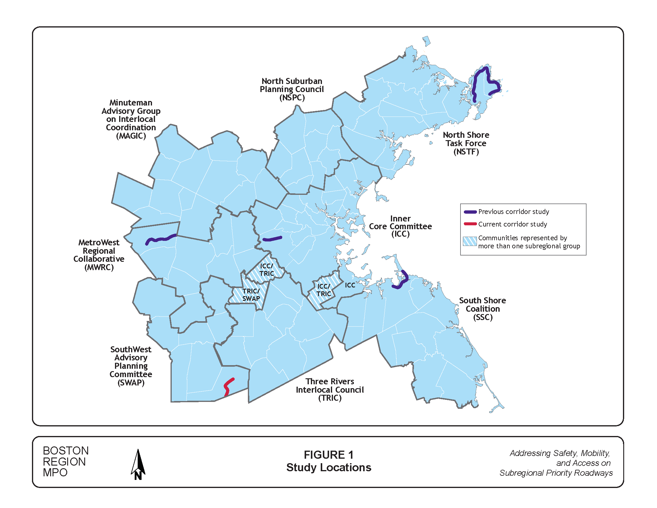
Figure 1 shows the locations of this selected and the previously studied corridors in the region. The selected roadway is about 3.1 miles long. It is classified as an urban minor arterial and is mainly a two-lane roadway except a four-lane section in the vicinity of Wrentham Village Premium Outlets and Interstate 495 Interchange. The roadway has no dedicated bicycle accommodation. Sidewalks exist on both sides only in the town center area and on one side only in the section west of Route 121. All of its sections are under MassDOT District 5’s jurisdiction. Several sections along the roadway are under consideration for development or redevelopment. This study would be timely for examining the corridor’s safety and operational issues, exploring multimodal opportunities, and connecting the corridor’s various projects in a consistent and cohesive approach.
Route 1A is one of the most significant commuter corridors in the South West Advisory Planning Committee (SWAP) subregion. The selected Route 1A section meets the objectives of this study, especially in supporting the transportation improvement priorities of the SWAP subregion.
MPO staff will submit this proposal to the MPO for discussion and approval. If the MPO approves this selection, staff will meet with officials from Wrentham, MassDOT, and MAPC to discuss the study specifics, conduct field visits, collect data, and perform various analyses.
CW/cw
| Roadway | Location | Community | MAPC Subregion | MassDOT District | Jurisdiction | Length (Miles) | Functional Classification |
Average Daily Traffic | Overall Crash Rate (MVMT) | Bike/Ped Crashes Per Mile | Top 200 High-Crash Locations 2012-2014 | HSIP-Eligible Crash Clusters 2012-2014 | Study, Project, or TIP Project | Safety Conditions | Multimodal Significance | Subregional Priority | Implementation Potential | Regional Equity | Score | Overall Assessment | Summary of Comments |
| Route 1A | Plainville town line to Route 140 | Wrentham | SWAP | 5 | MassDOT | 3.1 | 5 | 11,000 | 8.6 | 0.6 | 1 | 5 | Pre-TIP/MassDOT Project 603739: Construction of Route I-495/ Route 1A Ramps. The project is in a preliminary functional design stage with the 25% design under revision. MassDOT Project 605218: Resurfacing and Related Work on Route 1A. The purpose of this project was to improve the riding surface and maintain structural integrity of the pavement in various sections of Route 1A from Route 1 in North Attleborough to the Norwood/Westwood town line. MassDOT Project 600710: Safety Improvements, Route 1A (South Street) at Route 121 (West Street) (Wampum Corner); complete 2006. |
1 | 2 | 2 | 3 | 1 | 9 | High | Both MassDOT and the Town of Wrentham strongly support this corridor study. The corridor exhibits congestion in the vicinity of the Wrentham Premium Outlets and there is potential for additional significant development in the immediate area. The corridor also includes high crash locations and lacks bicycle/pedestrian accommodations. It would be worthwhile to study the corridor and provide recommendations to the town and MassDOT prior to additional development. Recent MassDOT Project 605218 includes the corridor in scope, but does not address pedestrian and bicycle accomodation, safety, and operational improvements. |
| Route 109 | Walpole town line to Interstate 95 | Westwood | ICC | 6 | Westwood | 4.1 | 3 | 16,500 | 4.4 | 1.7 | 0 | 2 | MassDOT Project 601315: Reconstruction of Route 109 (High Street) from Grove Street to Hartford Street. The project proposes to reconstruct High Street utilizing full depth reconstruction, including sidewalks, walls, drainage, curbing, signs, pavement markings, and new traffic signals are installed at Hartford Street, Gay Street, Windsor Road/Public Library Entrance and Summer Street. Construction ended in Spring 2008. | 1 | 2 | 2 | 2 | 1 | 8 | High | In FFY 2016 UPWP outreach, Medfield cited Route 109 as a major commute route to Interstate 95 that puts stain on the adjacent communities. Based on the comment, staff also examined this Westwood section. |
| Route 129 | Washington Street to Swampscott town line | Lynn | ICC | 4 | Lynn | 1.2 | 3 | 24,200 | 7.7 | 26.7 | 0 | 3 | No projects | 2 | 2 | 2 | 1 | 1 | 8 | High | The North Shore Task Force cited this roadway as one of the subregion's priority roadways for study in the FFY 2013 and FFY 2014 UPWP. High traffic volumes between Marblehead and Lynn are creating bottlenecks in this corridor. |
| Concord Avenue | Blanchard Road to Garden Street | Cambridge | ICC | 6 | Cambridge and DCR (between two rotaries) | 1.9 | 3 and 2 (between two rotaries) | 28,000 | 3.7 | 14.2 | 0 | 1 | TIP Conceptual Project #987 Minuteman Path Right-of-Way to aquire Watertown branch right-of-way to connect Minuteman Path from Arlington, Cambridge, and Watertown to Dr. Paul Dudley White Bike Path in Boston DCR announced a comprehensive study of the parkway system for bike lanes on December 18, 2014 (a small portion of this segment has DCR jurisdiction). |
2 | 2 | 1 | 1 | 1 | 7 | Medium | Comments in survey response on vision, goals, objectives in FFY 2015 LRTP outreach. For example, "eliminate designation of Concord Avenue as 'unrestricted arterial' street. It’s a narrow street with no wiggle room for bicycles when trucks pass." The small DCR portion of this segment is included in the comprehensive DCR study announced December 2014. |
| Washington Street | Dedham Street to Cobbs Corner | Canton | TRIC | 6 | Canton | 2.5 | 3 | 16,000 | 3.5 | 4.8 | 0 | 0 | No projects | 1 | 2 | 2 | 1 | 1 | 7 | Medium | Canton requested a study of the downtown section for signal coordination and pedestrian and bicycle safety and mobility improvements (2015 UPWP outreach). |
| Route 27 | Downtown Stoughton (School Street to Kinsley Street) | Stoughton | TRIC | 5 | Stoughton | 0.6 | 3 | 17,550 | 14.0 | 25.0 | 1 | 0 | Stoughton Downtown Station Area Plan: With a technical assistance grant from MassDOT, the Town began a planning effort centered on the Stoughton Train Station and the surrounding areas looking at redevelopment potential within the Downtown. A “Kick-off” announcement was made at the April 27th (2016) Board of Selectmen Meeting publicizing the commencement of work. Studies done by Greenman-Pederson, Inc. include immediate, short-term, mid-term, and long-term fixes to traffic near Downtown (Feb. 27, 2015, The Enterprise Stoughton News). |
2 | 2 | 1 | 1 | 1 | 7 | Medium | This location is suitable for a subarea (downtown) transportation study, instead of a corridor study. TRIC cited this roadway in the UPWP FFY 2013 and 2016 outreach. The concerns mainly are related to MBTA train operations and parking needs. The on-going study, Stoughton Downtown Station Area Plan, covers a major portion of the roadway. |
| Route 27 | Upland Road (near Pine Grove Avenue) to Massapoag Brook (between Canton Street and Gabriel Road) | Sharon | TRIC | 5 | Sharon | 1.7 | 3 | 13,900 | 2.4 | 2.9 | 0 | 0 | No projects | 1 | 1 | 2 | 2 | 1 | 7 | Medium | TRIC cited this roadway in the UPWP FFY 2012 outreach. |
| Route 117 | Weston town line to Route 20 | Waltham | ICC | 4 | Waltham, MassDOT (0.05 mile section at Interstate 95) | 1.3 | 5 | 17,500 | 3.3 | 4.6 | 0 | 0 | No projects | 1 | 2 | 2 | 1 | 1 | 7 | Medium | In FFY 2012 UPWP outreach, Waltham proposed this roadway for the Priority Corridor study. Major proposals include widening the bridge over Route 128, connecting Route 2 by extending Green Street, and other critical intersection improvements. In FFY 2016 UPWP outreach, MetroWest proposed this corridor as part of a subarea study that includes Route 20 and Route 30 between Waltham and Weston. |
| Route 38 | Woburn town line to Tewksbury town line | Wilmington | NSPC | 4 | MassDOT | 4.0 | 3 | 17,500 | 5.2 | 5.3 | 0 | 5 | Pre-TIP/MassDOT Project 608051: Reconstruction on Route 38 (Main Street), from Route 62 to the Woburn city line. The roadway will consist of two 11-foot lanes, two five-foot bike lanes and a six-foot sidewalk. Turn lanes and upgraded traffic signals will be installed at Route 62; preliminary design phase. Pre-TIP/MassDOT Project 607327: Bridge Replacement, Route 38 (Main Street) over the Boston and Marine Corporation Railroad; preliminary design phase. |
2 | 2 | 1 | 1 | 1 | 7 | Medium | Pre-TIP #608051 has a scope covering half of the segment's length. The project is under design. NSPC cited this roadway during the UPWP outreach for FFYs 2013 and 2014. Both Routes 38 and 62 serve as conduits through Wilmington to I-95 and I-93, and contain congested signalized intersections and traffic and pedestrian safety issues. |
| Route 35 | Route 97 in Topsfield to Route 114 (Margin St.) in Peabody | Topsfield (less than 0.05 mi), Danvers, Peabody | NSTF | 4 | Topsfield (less than 0.05 mi), Danvers, Peabody, MassDOT | 6.0 | 5 | 17,250 | 2.4 | 1.8 | 0 | 1 | Advertised TIP #606609 Bridge Replacement, Route 35 (Water Street) over Waters River MassDOT Project #87612 Reconstruction of two Interchanges on Route 128, with Route 62 and with Route 35; complete Autumn 2012 |
1 | 2 | 2 | 1 | 1 | 7 | Medium | NSTF cited this roadway during the UPWP outreach for FFYs 2013 and 2014. Verbal comments were made a MAPC subregion meeting and a letter for the FFY 2014 UPWP was submitted. |
| Route 129 | Swampscott town line to Ocean Ave. | Marblehead | NSTF | 4 | Marblehead | 1.5 | 3 | 12,100 | 2.2 | 2.7 | 0 | 0 | No projectsConceptual TIP Arterial and Intersection Project 972 Atlantic Avenue (Route 129) ends at the location boundary, near Seaview Avenue in Marblehead |
1 | 2 | 2 | 1 | 1 | 7 | Medium | The North Shore Task Force (NSTF) cited this roadway as one of the subregion's priority roadways for study in the FFY 2013 and FFY 2014 UPWP. High traffic volumes between Marblehead and Lynn are creating bottlenecks in this corridor. |
| Route 127 | Route 133 in Gloucester to Route 127A in Rockport | Gloucester, Rockport | NSTF | 4 | MassDOT, Gloucester, Rockport | 4.7 | 3, 5 | 16,950 | 1.7 | 1.7 | 0 | 1 | No projects | 1 | 2 | 2 | 1 | 1 | 7 | Medium | NSTF cited this roadway during the UPWP outreach for FFYs 2013 and 2014. Study should include how to improve bike facilities and bike-to-rail connections in this heavily traveled tourist area and build on the Essex Coastal Scenic Byway to the region. |
| Route 38 | I-95 Interchange to Wilmington town line | Woburn | NSPC | 4 | MassDOT, Woburn | 1.4 | 3 | 19,250 | 6.9 | 3.6 | 0 | 2 | Conceptual (2013) TIP Arterial and Intersection Project #1449 Route 38 (Main Street) Traffic Lights, consisting of replacing outmoded traffic signal controls for the twelve signalized intersections along Route 38 in Woburn |
2 | 1 | 2 | 1 | 1 | 7 | Medium | NSPC and Woburn requested a study of the I-95 rotary interchange and the traffic signals at Route 38 and Elm Street. The area north of I-95 recently reconstructed by developer. MassDOT District 4 notes high crash locations at Elm Street and at the I-95 Rotary. While a study may have value, they suggested that a Road Safety Audit (RSA) may be a more appropriate way to address these locations. |
| Route 114 | Salem town line to Route 129 (Ocean Ave) | Marblehead | NSTF | 4 | Marblehead | 1.4 | 3 | 16,750 | 2.7 | 6.4 | 0 | 0 | No projects | 1 | 1 | 2 | 2 | 1 | 7 | Medium | NSTF cited this roadway during the UPWP outreach for FFYs 2013 and 2014. Study should include how to improve bike facilities and bike-to-rail connections in this heavily traveled tourist area and build on the Essex Coastal Scenic Byway to the region. |
| Route 129 | Lynn town line to Marblehead town line | Swampscott | NSTF | 4 | Swampscott, DCR (less than 0.1 mi) | 2.5 | 3 | 19,000 | 1.9 | 5.2 | 0 | 0 | Community Transportation Technical Assistance Program, CTPS and MAPC Study Conceptual TIP project 972: Atlantic Avenue (Route 129), roadway rehabilitation from Puritan and Humphrey to the Marblehead town line |
1 | 2 | 2 | 1 | 1 | 7 | Medium | Part of the segment falls under a conceptual TIP project. NSTF cited this roadway in 2012 as one of the subregion's priority roadways for study in the FFY 2013 and 2014 UPWP. Segment in downtown Swampscott is a bottleneck for those traveling from Marblehead to Lynn. MassDOT District 4 notes that the intersection of Route 129 and Burrill Street is a high crash location and an RSA could address safety and congestion issues. |
| Route 109 | Millis town line to Dover town line | Medfield | TRIC | 3 | Medfield | 3.2 | 3 | 16,000 | 3.0 | 1.9 | 0 | 0 | MassDOT Project 601654: Roadway reconstruction including signals on a section of Route 109 (Main Street). The project is in the preliminary design phase. | 0 | 2 | 2 | 2 | 1 | 7 | Medium | In FFY 2016 UPWP outreach, Medfield cited Route 109 as a major commute route to Interstate 95 that puts stain on the adjacent communities. |
| Edgell Road | Route 9 to Water Street in Framingham | Framingham | MetroWest | 3 | Framingham | 2.2 | 5 | 18,500 | 3.5 | 1.8 | 0 | 0 | Pre-TIP 602038 Edgell Road Corridor Project: Reconstruct pavement and improve signalization at Water St, Brook St, Central St, and Vernon St (close to Route 9) No projects in MassDOT project database. |
1 | 2 | 2 | 2 | 0 | 7 | Medium | The roadway was first mentioned in FFY 2008 UPWP outreach and cited in the MetroWest Working Group Meeting in 2016. |
| Route 37 | Braintree town line to Brockton town line | Holbrook | SSC | 5 | MassDOT and Holbrook | 3.6 | 3 | 15,500 | 5.1 | 3.9 | 1 | 2 | FFY 2013 Safety and Operations at Intersections Conceptual TIP #1044 Intersection improvements at South Franklin Street and King Road |
2 | 1 | 2 | 1 | 0 | 6 | Medium | Not suitable for selection since the SSC subregion is already well-represented by past Subregional Priority Roadways projects. The Town of Holbrook has been in contact with the district and is interested in improvements, particularly multimodal transportation improvements. |
| Main Street | Wakefield town line to Central Street | Saugus | ICC | 4 | Saugus and MassDOT | 2.9 | 3, 5 | 16,950 | 2.6 | 2.1 | 0 | 1 | No projects |
1 | 2 | 1 | 1 | 1 | 6 | Medium | In FFY 2012 UPWP outreach, Saugus requested the MPO to consider performing a roadway/sidewalk/traffic light/pedestrian access assessment study, to be called a Main Street/Saugus Center Corridor Study. |
| Route 3A | Burlington Mall Road to Francis Wyman Road (Route 62) | Burlington | NSPC | 4 | MassDOT | 3.8 | 3 | 23,100 | 2.5 | 1.1 | 0 | 2 | TIP Programmed/MassDOT Project 608068: Adaptive Traffic Control Signal System on Cambridge Street (Route 3A), Middlesex Turnpike Road, and Burlington Mall Road. Installation of compatible traffic signal control equipment, video detection, communication devices and software to integrate 11 MassDOT and 16 Town owned traffic signal locations into one adaptive signal system. | 1 | 2 | 1 | 1 | 1 | 6 | Medium | MPO staff identified this roadway segment. MassDOT District 4 expressed interest in examining the inconsistent roadway cross-sections and the potential for pedestrian and bicycle accommodations in 2015. It's now considered low priority as Project 608068 advanced in 2016. |
| Route 127 | Route 1A in Beverly to Route 133 in Gloucester | Beverly, Manchester-by-the-Sea, Gloucester | NSTF | 4 | MassDOT, Manchester, Beverly | 13.6 | 5, 6 | 4,850 | 1.8 | 0.9 | 0 | 1 | Advertised TIP project 607441: Safe Routes to School includes about 0.10 mi of Route 127 near Lincoln Street in Manchester; construction is underway. MassDOT Project #607707 Resurfacing and Related Work on Route 127; preliminary design phase (last updates from 2013). Advertised (2013) TIP Project 600220 in construction on Route 1A in Beverly terminates near the intersection with Route 127. |
0 | 2 | 2 | 1 | 1 | 6 | Medium | MassDOT Project #607707, which is currently in the preliminary design phase, covers two-thirds of the segment in scope. NSTF cited this roadway during the UPWP outreach for FFYs 2013 and 2014. Study should include how to improve bike facilities and bike-to-rail connections in this heavily traveled tourist area and build on the Essex Coastal Scenic Byway to the region. |
| Route 53 | Route 123 to Route 139 | Hanover | SSC | 5 | MassDOT | 3.5 | 3 | 22,500 | 2.3 | 1.1 | 0 | 0 | Advertised (2009) TIP/MassDOT Project 602602: Reconstruction of Washington Street (Route 53) and Related Work, from the Route 3 (NB) Ramp to Webster Street (Route 123). Prime Contractor has performed hydrant relocation, road widening excavation, drainage installation, and road cold planing and binder paving. Sidewalks and curb work are completed with final paving in Spring 2017. Pre-TIP 607758: Intersection and Signal Improvements on Route 53 (Columbia Road) at Route 139 (Rockland Street) MassDOT Project 607715: Resurfacing and Related Work Route 53; preliminary design phase. |
0 | 1 | 2 | 2 | 0 | 5 | Low | SSC cited this roadway during the UPWP outreach for FFYs 2013 and 2014 via a formal letter and verbal comments at MPAC subregion meeting and stressed that this north-south corridor, as a direct connection to and from Route 3 Exit 13, serves many south shore communities, and a major route between Route 123 and Route 139. |
| Route 97 | Route 1A in Beverly to Topsfield/ Boxford town line | Beverly, Wenham, Topsfield | NSTF | 4 | Beverly, Wenham, Topsfield | 8.9 | 5 | 15,000 | 0.8 | 0.3 | 0 | 1 | MassDOT Project #604028 Intersection Improvements on Route 97 (Topsfield Road) at Cherry and Maple Streets; complete 2009. Pre-TIP Project 605020: Border (New Hampshire) to Boston Bikeway intersects Route 97 in Wenham. |
0 | 2 | 1 | 1 | 1 | 5 | Low | NSTF proposed to study this segment in conjunction with the Route 97 corridor in Boxford, Georgetown, and Haverhill (Merrimack Valley Planning Commission). This may have implementation challenges. Segment mentioned in Fall 2014 LRTP Outreach and Fall 2012 via public comment and a letter for the FFY 2014 UPWP Universe. |
| Route 133 | Route 127 in Gloucester to Route 1A in Ipswich | Essex, Gloucester, Ipswich | NSTF | 4 | MassDOT, Essex | 11.0 | 5, 6 | 10,500 | 0.7 | 0.2 | 0 | 0 | MassDOT Project 602146: Resurfacing and Related Work on a Section of Route 133 (Essex Road). The project includes pedestrian improvements from the intersection of Route 1A to the Essex Town Line, a distance of approximately two miles; complete spring 2011. MassDOT Project 600217: Reconstruction of Route 133 (Main Street) from North of Western Avenue to Waters Street in Essex (about one mile). It includes concrete sidewalks and pavement markings; complete autumn 2013. |
0 | 2 | 1 | 1 | 1 | 5 | Low | MassDOT Project 602146 covers all of the Ipswich portion of the segment, and 600217 covers some of the Essex portion. This is the last of three sections proposed for study by Essex National Heritage Commission. It was cited in the 2013 UPWP outreach. A two-mile section in the Essex downtown area was recently reconstructed (summer 2011). |
| Route 2A/King Street | Route 495 Southbound ramps to Ayer town line | Littleton | MAGIC | 3 | MassDOT | 2.5 | 3 | 15,000 | 1.5 | 0.4 | 0 | 0 | MassDOT Project 605504: Bridge Betterment, Route 2A (King Street) over I-495; scheduled to complete in 2013. | 0 | 2 | 2 | 0 | 1 | 5 | Low | Requested by Littleton in 2015. |
Notes:
* Functional Classification
2 = principal arterial, 3 = rural minor arterial or urban principal arterial, 5 = urban minor arterial or rural major collector, 6 = urban collector or rural minor collector
** Selection Criteria
Safety Conditions: Location has a high crash rate for its functional class or contains areas with a high number of crashes or with a significant number of pedestrian/bicycle crashes.
Multimodal Significance: Location supports transit, bicycle, or pedestrian activity, has significant potential to enhance these activities, or has a heavy vehicle (truck/bus) issue.
Subregional Priority: Location carries a significant proportion of subregional vehicle, bicycle, or pedestrian traffic or is essential for its subregional economic, cultural, or recreational development.
Implementation Potential: Location is proposed or endorsed by the subregion, by the roadway administrative agency (agencies) or has strong support from all of its stakeholders.
Regional Equity: Location is situated in a subregion that has not been selected for this study in the past two years.
AcronAcronyms and Abbreviations
AADT = Annual average daily traffic. ADA = Americans with Disabilities Act. ADT = Average daily traffic. BAT = Brockton Area Transit Authority. CTPS = Central Transportation Planning Staff. DCR = Department of Conservation and Recreation. DEIR = Draft Environmental Impact Report. EJ = Environmental justice. ENHC = Essex National Heritage Commission. EPDO = Equivalent property damage only. FFY = Federal fiscal year. GATRA = Greater Attleboro Taunton Regional Transit Authority. HSIP = Highway Safety Improvement Program. ICC = Inner Core Committee. LRTP = Long-Range Transportation Plan. MAGIC = Minuteman Advisory Group on Interlocal Coordination. MAPC = Metropolitan Area Planning Council. MassDOT = Massachusetts Department of Transportation. MBTA = Massachusetts Bay Transportation Authority. MVMT = Million vehicle miles traveled. MetroWest = MetroWest Regional Collaborative. MPO = Boston Region Metropolitan Planning Organization. MWRTA = MetroWest Regional Transit Authority. NSPC = North Suburban Planning Council. NSTF = North Shore Task Force. RSA = Road safety audit. RTA = Regional transit authority. SSC = South Shore Coalition. SWAP = South West Advisory Planning Committee. TIP =
Transportation Improvement Program. TRIC = Three Rivers Interlocal Council. UPWP = Unified Planning Work Program.
Source: Central Transportation Planning Staff.
1 Unified Planning Work Program, Federal Fiscal Year 2017, endorsed by the Boston Region Metropolitan Planning Organization on July 28, 2016.
2 Work Program for Addressing Priority Corridors from the Long-Range Transportation Plan Needs Assessment: Federal Fiscal Year 2017, approved by the Boston Region MPO on December 15, 2016.
3 HSIP-eligible crash clusters are defined by MassDOT as crash clusters that rank within the top five percent of crash clusters for each Regional Planning Agency, based on the Equivalent Property Damage Only (EDPO) index. In the EDPO index, property-damage-only crashes are awarded one point each, crashes involving injuries are given five points each, and fatal crashes are given ten points each. In the Boston Region MPO, 939 intersections are identified from MassDOT 2012–14 Crash Data as the top five percent crash clusters with a minimum EDPO value of 41.
4 Pedestrian Level-of-Service Memorandum, Ryan Hicks and Casey-Marie Claude, Boston Region Metropolitan Organization, January 19, 2017.