Technical Memorandum
DATE: January 18, 2018
TO: Boston Region Metropolitan Planning Organization
FROM: Casey Claude, Boston Region MPO Staff
RE: Bicycle Network Gaps Feasibility Evaluations – Massachusetts Central Rail Trail
Local, regional, and state government agencies are working to improve the Boston region’s bicycling infrastructure to enhance safety and provide more connectivity for bicyclists, and to increase the use of bicycles as a mode of transportation. These goals have already fostered construction of many bicycle facilities, such as shared-use paths, on-road bike lanes, and barrier-separated bike lanes (or cycle tracks). Hence, today the Boston region boasts a strong network of these types of bicycle facilities, which connect to major destinations such as town centers and transit hubs. However, within this network, there are gaps in continuity (that is, a gap within one path) and connectivity (meaning a gap between one path and another path, or a path and a roadway or transit service). Because these physical gaps cause bicyclists to use circuitous routes, they make it less efficient to travel between key origins and destinations—work and home, for example. These gaps exist for a number of reasons, including a lack of coordinated planning, shortage of funds, right-of-way (ROW) constraints, competition for ROW space, issues related to construction or repair work that spans multiple jurisdictions, and physical obstructions, such as waterways, bridges, roadways, and railroads.
In 2014, the Boston Region Metropolitan Planning Organization (MPO) staff conducted the Bicycle Network Evaluation study, which assessed 234 gaps in the region’s bicycle network. This work resulted in a list of gaps that were a high priority for attention based on their potential to improve regional connectivity or continuity.1 In this study, staff used a set of criteria to gauge, or score, the gaps that, if closed to connect two bicycle facilities, would have the greatest potential to improve the Boston region’s bicycle network.
For the evaluation, MPO staff organized the identified gaps into three categories, those that are 1) less than one-half mile long (“small” gaps), 2) between one-half and one- and one-half mile long (“medium” gaps), and 3) more than one- and one-half mile long (“long” gaps). Since long gaps would tend to score higher than small or medium gaps—because of the likelihood of there being more amenities or possibilities for making connections along a longer stretch of roadway or trail—the evaluation identified the highest scoring gaps in each length category. So, while a small gap may have scored lower than some long gaps, the small gap could still be identified as a “high-priority” gap based on the high score it received relative to other small gaps.
This memorandum is one of three 2018 documents that, building upon the 2014 study, evaluates in detail three high-priority gaps—one in each category above. The potential improvements for these three areas recommended by MPO staff may be considered for design and construction funding in future Transportation Improvement Program (TIP) cycles. This memorandum reports on a detailed feasibility evaluation that was conducted for one of the highest-priority, long gaps identified in the 2014 study.
In the Bicycle Network Evaluation, MPO staff identified the gap between Waverly Station and Kendal Green Station on the Massachusetts Central Rail Trail (MCRT), which fell into the long category, as one of the 11 highest-priority gaps in the Boston region bicycle network.2 The study scored the gaps according to a number of criteria, including: Would bicycle facilities in place of the gap provide access to critical destinations, such as places of employment, schools, medical offices, shopping districts, town centers, or open spaces? What is the probability that providing bicycle facilities at a specific gap location would attract large numbers of bicyclists and pedestrians? Would new bicycle facilities correct existing safety issues by providing safe routes through or around high crash locations?
The highest possible score that a gap could receive was 25.3 The MCRT gap in Waltham scored 20 points to tie with the Canal Street Bikeway gap in Salem (medium category). The scores of these gaps were surpassed only by the Somerville Community Path gap (long category), which received 24 points. When MPO staff began this study, efforts were already underway to secure funding for construction of the Somerville Community Path that would address the gap in the shared-use path; thus, the Somerville Community Path gap was not eligible for this study.
The 2014 study cited land ownership as a potential challenge to closing the MCRT gap and stated that, as a next step, it would be important to identify land ownership and resolve ROW issues. The study also pointed out that, once the identified MCRT gap is paved and a shared-use path linking the two Fitchburg Line commuter rail stations is created, it will be necessary to assign responsibility for MCRT maintenance. The study also noted that the Massachusetts Department of Conservation and Recreation (DCR) had already secured a lease for the property from the Massachusetts Bay Transportation Authority (MBTA), along with funding for preliminary planning.
In 1997, the Boston Region MPO explored the feasibility of converting the abandoned Central Massachusetts Railroad ROW into a shared-use path for bicyclists and pedestrians.4 MPO staff explained that the proposed project, known as the MCRT, would stretch 23 miles from Beaver Street in Waltham to Coburn Road in Berlin, passing through seven municipalities: Belmont, Waltham, Weston, Wayland, Sudbury, Hudson, and Berlin.5 The ROW crosses the Assabet River Rail Trail in Hudson and the Bruce Freeman Rail Trail in Sudbury, providing connections to the larger bicycling and walking network in the Boston region while simultaneously providing local access to employment, schools, residential areas, and recreation.6
The study concluded that it would be possible to build the shared-use path, and outlined the steps needed to proceed. Each municipality must 1) agree to police and maintain the portion of the MCRT within its boundaries; 2) establish lease agreements by negotiating with the MBTA, the owner of the Central Massachusetts Railroad ROW; 3) submit applications for design funds to create an engineering plan, including detailed construction estimate for the entire proposed trail; and 4) bid out the construction contract and award to the lowest responsible bidder.7
Two decades have passed since the Boston Region MPO published its MCRT feasibility study.8 The entire corridor has met Massachusetts Environmental Policy Act (MEPA) requirements, so the municipalities will need to approach their conservation commissions to take the next step in permitting their MCRT projects. In 2011, DCR negotiated a 99-year lease with the MBTA for 23 miles of the Central Massachusetts Railroad ROW from Linden Street in Waltham to the Town of Berlin with the intent of developing a multi-use rail trail in partnership with local municipalities. The lease specifies a 19-foot cross section, which means that space for the trail will be constrained in a way that may not leave room for screens and plants; in some instances, it may be necessary to ask the MBTA for more space. DCR strongly prefers asphalt surfaces to other materials and requires that the MCRT meets Americans with Disabilities Act (ADA) requirements.
The path of the MCRT intersects Waverly Station and crosses the Fitchburg Line approximately one-third mile south of Kendal Green Station. Although one terminus is in Belmont and the other is in Weston, the majority of this segment is located in Waltham (see Figures 1 and 2). Figure 1 illustrates the MCRT’s path and its status—existing, in design or under construction, and envisioned for the future. While much of the MCRT in Waltham is marked as existing, Figure 2 shows that the only part of the trail that has been paved with asphalt is one small segment of the trail, which developers included as part of their work at 1265 Main Street in Waltham. The other existing MCRT segments in Waltham are either unimproved or consist of graded earth or soil.
Figure 1 – Facility Status (Massachusetts Central Rail Trail Gap)
Figure 2 – Trail Surface of Existing Segments (Massachusetts Central Rail Trail Gap)
 road or unimproved/graded earth/soil surface road – of the existing segments of the Massachusetts Central Rail Trail along the gap in Belmont, Waltham, and Weston. The map also indicates which portions of the trail, for the time being, remain simply envisioned or planned.")
The portion of the MCRT within Waltham, much of which is used as a walking path, is approximately three miles long. The ROW along the Waltham segment of the MCRT is kept clear by Waltham Land Trust (WLT) volunteers. A representative from the WLT is included on the Rail Trail Advisory Committee designated by Waltham’s Mayor McCarthy. In June 2017, at the Mayor’s request, Waltham received Community Preservation Act (CPA) funds for trail design documents, which allowed Waltham to award Pare Corporation a contract to design the path through to the 25 percent design phase. Their contract includes the tasks of land surveying, public engagement, and preliminary design. Afterwards, leading up to the construction bidding process, engineers from Pare Corporation will develop construction plans and pursue regulatory permits. Waltham has not yet identified funding for construction of the rail trail.
The eastern terminus of DCR’s 23-mile lease is located at Linden Street in Waltham, so there are some ROW concerns along the remainder of the gap between the Linden Street Bridge and Waverly Station in Belmont. The segment just east of the Linden Street Bridge has Business B zoning but the Waltham website does not indicate any ownership of the land. Between the Business B parcel and Beaver Street, there is a parcel with commercial zoning, also without any indication of ownership. East of Beaver Street the zoning continues as commercial but the City of Waltham lists Beaver Group, LLC, as the owner and C/O Duffy Association as the co-owner of the parcel. This parcel extends east from Beaver Street to the Belmont border, south of the Beaver Brook Reservation. The entirety of this MCRT segment from the Linden Street Bridge to Belmont will need to be addressed as planning for the rail trail continues in order to ensure continuity of the MCRT through Waltham from Belmont to Weston.
As explained above, the MCRT segment in Belmont that forms the eastern end of the gap is not included as part of DCR’s 23-mile lease. The ROW in Belmont is not intact but the town is making progress. In December 2014, the Belmont Selectmen appointed the new Community Path Implementation Advisory Committee (CPIAC) to continue the work of the 2012−14 Community Path Advisory Committee (CPAC). CPIAC drafted a request for proposals (RFP) to assess the feasibility of a Belmont Community Path that would extend MCRT routes to Waltham’s border at the Beaver Brook South Reservation. In 2016, Belmont posted an RFP for an engineering study that would identify how the MCRT at Brighton Street in Belmont could be linked to the MCRT at the Waltham border. Belmont contracted with the Pare Corporation to conduct a Feasibility Study of the Community Path and the final draft of the Feasibility Study for the Belmont Community Path was published in November 2017.9 The Belmont study goes beyond the scope of work for this project and should be referred to for next steps in closing the MCRT gap in Belmont.
The western terminus of the MCRT gap near Kendal Green Station marks the start of three miles of the rail trail in Weston, which currently is used as a walking path. The Weston Selectmen created a rail trail advisory committee in April 2016, although there had not been much public discussion in the town about the rail trail prior to the committee’s creation. At that time, Eversource was going through the permitting process in order to build a maintenance road in the town along the rail trail ROW but the company had yet to file an application with the Conservation Committee. In October 2017, Eversource began constructing 4.5 miles of trail sub-base and gravel road for the MCRT in Weston and Wayland, accomplished through a public/private partnership with DCR. Once Eversource completes its work, DCR will pave the trail surface, install loam, seed shoulders, and add safety rail fencing when necessary to protect trail users from adjacent steep slopes. The project is expected to be completed in the spring of 2018.
MPO staff met with staff from the city of Waltham, the town of Belmont, the Massachusetts Department of Transportation (MassDOT), Metropolitan Area Planning Council (MAPC), and MassDOT Highway District 4 on October 27, 2015. At the meeting, MPO staff learned about the gap in the MCRT between Waverly Station and Kendal Green Station on the Fitchburg commuter rail line. Waltham representatives informed MPO staff that there is public support in the city for creating a shared-use path along the old Central Massachusetts Railroad corridor from 1265 Main Street to the old rail bridge that crosses Linden Street (see Figure 3). As noted previously, the developer at 1265 Main Street paved a shared-use path along the old rail corridor on the north side of the property that, one day, is expected to connect to shared-use paths leading east and west through Waltham to the remainder of the MCRT on either side.
As identified by Waltham staff, the next important step towards constructing the MCRT in Waltham would be to understand the shared-use path and rail-trail design requirements. Section 3.1 of this memorandum summarizes recommendations for shared-use path width, considerations of user comfort, and grade requirements for accessibility based on Massachusetts and federal regulations.
The public in Waltham would like an off-road, shared-use path facility of the same high quality as the Minuteman Commuter Bikeway, although Waltham representatives expressed interest in improving upon the Minuteman’s roadway crossings. In Section 3.2 of this memorandum, MPO staff present guidance about creating safe intersections between shared-use paths and roadways.
Figure 3 – Trail Segment Supported by Waltham Public (Massachusetts Central Rail Trail Gap)

MPO staff reviewed Massachusetts and federal guidance about shared-use paths and rail trails in order to address the concerns expressed at the MCRT gap study kick-off meeting. This memorandum first addresses regulations related to segments of shared-use paths and rail trials, then discusses best practices for constructing roadway crossings.
At the kick-off meeting on October 27, 2015, municipal staff asked for an overview of the federal and state design regulations to which the rail trail would need to adhere. They were most interested in three topics: 1) width requirements; 2) DCR and MassDOT regulations that could limit the proximity of rail trails to active railroad lines; and 3) designing the trail at the location where an inaccessible, steep, gravel slope meets the east end of the shared-use path paved by the developer at 1265 Main Street along the old rail corridor on the north side of the property. This section explains current state and federal regulations that would affect these topics.
To accommodate users of the paved MCRT shared-use path safely and effectively, it is important that the path is wide enough for the number and type of users expected to travel on it. Therefore, width is a key factor in determining suitability for bicyclists, and by extension, minimizing the degree of conflict between people biking, walking, and using other wheeled mobility devices. In 2006, the Federal Highway Administration (FHWA) released its Shared-Use Path Level of Service Calculator, a tool for determining bicycle level of service (LOS) on shared-use paths. Bicycle LOS, as defined by the FHWA calculator, assigns six LOS ratings that range from A (best) to F (worst). It also considers operating conditions related to 1) maintaining an optimum bicyclist speed, and 2) affording bicyclists the freedom to maneuver. The calculator assesses this second condition via user-perception surveys, along with four measurable events captured on video tape:
In cases where the volume of users is very low or where the mix includes few pedestrians and runners, eight-foot-wide shared-use paths may be acceptable.11 Eight-foot-wide trails, which typically have poor LOS for bicyclists, are recommended by the American Association of State Highway and Transportation Officials (AASHTO) only in “rare instances.”12 FHWA research found that shared-use paths of between 11 and 15 feet wide provide “improved LOS for higher volumes and more balanced user mixes than narrow widths [provide].”13
The FHWAtested its calculator on the Minuteman Bikeway in Arlington.14 The Minuteman Bikeway, which runs from Cambridge to Bedford, is 12 feet wide, attracts 442 people per hour, and experiences bicyclist LOS C. We may use this data as a proxy for anticipated travel along the MCRT once it is paved and accessible. If the MCRT eventually attracts as many users as the Minuteman Bikeway, a trail width of at least 12 feet could help achieve bicyclist LOS C or better, although this also would depend on the mix of users. However, even if some sections of the MCRT paved path need to be constrained to widths narrower than 12 feet, that factor should not prevent the MCRT from being developed. Every additional foot of trail has a positive impact on bicyclist LOS. If a particular spot cannot accommodate a shared-use path in two-foot increments, then instead of giving up trail space, trail designers and decision makers could consider one-foot increments.
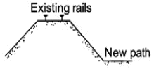
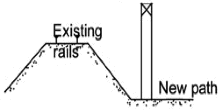
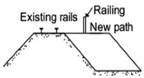
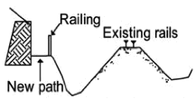
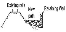
In locations where the existing railroad ROW is constrained, methods such as modifying the ROW cross section or redirecting the path can increase the width available for path development (see Table 1).15
Table 1
Methods for Increasing Path Width in Constrained ROW
| Method |
Illustration |
|---|---|
|
|
|
|
|
|
|
|
|
|
|
|
ROW = Right of way.
Sources: 1) Project Development & Design Guide, Chapter 11: Shared Use Paths and Greenways; Massachusetts Highway Department; January 2006; page 11-34; 2) http://lifeonabridged.blogspot.com/2012_07_01_archive.html.
Bicyclist LOS on shared-use pathways is very sensitive to user mix. When the amount of runners and pedestrians exceeds 15 percent of trail users, bicyclist LOS is significantly affected. Multilane striping or multiple treadways (travel routes) can help achieve separation between bicycle and pedestrian modes to improve bicyclist LOS and reduce user conflicts. While there are limited examples of trails with multilane striping, FHWA guidance states that “it is likely that having sufficient trail width for a four-lane operation (a minimum of [15 feet]) increases the ability of bicyclists to pass slower-moving users without encountering blockage from trail users in the opposing lanes.”16 Four-lane shared-use paths are striped with two lanes in each direction, providing pedestrians and cyclists with their own space while traveling in the same direction.
Multiple treadways also may be created to accommodate a variety of users; for example, a three-lane trail with one lane for pedestrians and two lanes in each direction (minimum combined width of 11 feet) for bicyclists and skaters. Including more than one treadway in the same trail corridor allows one or two user types to occupy one of the treadways exclusively. If this strategy effectively reduces the number of pedestrians and runners mixing with bicyclists, then including more than one treadway also would improve bicyclist LOS significantly.17 When contemplating multiple treadways, however, it is important to consider how to enforce compliance with restrictions that allow only specific types of users on a treadway.
In order to ensure safety, adequate separation between a shared-use path and an active rail line is critical. Often, there is space within the width of a railroad ROW that is not being actively used for railroad purposes—a buffer of sorts that potentially could be used for path development. The minimum distance between a trail and an active rail is calculated using the speed and frequency of train travel along a corridor. The Fitchburg Commuter Rail Line is considered a high-speed and high-volume line because its trains travel at 45 miles per hour (mph) or more (maximum) and there are more than 11 trips per day on the line. Table 2 below cites the minimum recommended separations between a path and an active rail line for trains with characteristics similar to the Fitchburg line.18 Because the minimum separation measurements vary by a location’s condition, it is possible to negotiate exceptions to the recommendations in Table 2 with the track owner/operator on a case-by-case basis.19
Table 2
Minimum Separations between Shared-Use Path and Active Rail*
Setting Characteristics |
Recommended Minimum Separation |
Typical Conditions |
25 feet with fence |
Typical Conditions |
15 feet with a solid barrier |
Constrained Areas (cut/fill, bridges, etc.) |
15 feet with fence/other physical barrier |
Vertical Separation (more than 10 feet) |
20 feet |
*Based on maximum speed of more than 45 mph, and running more than 11 trips per day.
Source: Project Development & Design Guide, Chapter 11.
A segment of paved shared-use path currently exists behind 1265 Main Street in Waltham. On its eastern side, the pavement ends abruptly at the top of a steep, gravel hill that would be inaccessible to trail users with mobility impairments. DCR strongly prefers asphalt to other surface materials and requires that its trails meet ADA requirements. The existing gravel surface, therefore, will need to be paved. However, simply paving the hill will not solve the accessibility issues at the location; concerns related to the grade of the path will need to be addressed.
Sloped surfaces require more energy to traverse than those that are level; therefore, navigating slopes can be difficult for people with mobility impairments. The general rule for shared-use paths is that their running grades should not exceed five percent, and that the most gradual slope possible should be put in place. Resting opportunities along a shared-use path with a steep running grade can offer some relief to these users, and should be provided as both “rest areas” and “rest intervals.” The major difference between the two is that rest areas have more space, allowing for more amenities. The width of well-designed rest areas and intervals should be equal to or greater than the width of the path segment leading to and from the resting location and should measure a minimum of 60 inches long.20 Federal guidance states that rest areas and intervals may not exceed a grade of five percent, although DCR requires that rest intervals do not exceed a three percent grade.21 In addition, rest intervals should occur within 25 feet of the top and the bottom of a maximum grade segment; they also should be located adjacent to the path, although they may be placed within the path itself.22
If a shared-use path must include steep stretches, then less than 30 percent of the total trail length should exceed a grade of 8.33 percent. It is important to minimize the length of steep sections and to ensure that other barriers along the paths are removed so that users with mobility impairments do not become overly fatigued. The FHWA has recommended maximum lengths for three different shared-use path segment grades:
It is important to adhere to FHWA grade guidance so that the MCRT is accessible to all users. Using the Google Maps measurement tool, MPO staff estimated that the sloped area behind 1265 Main Street measures approximately 80 feet long. When the MCRT is constructed in Waltham, the steep gravel hill will need to be replaced by a new paved path with a grade no greater than 9.5 percent, assuming a linear relationship between the grades permitted for slopes 30 feet and 200 feet long.
In Waltham, between Waverly Station and the paved shared-use path behind 1265 Main Street, there are seven at-grade crossings along the MCRT route:
In addition to these, two grade-separated crossings are served by old Central Massachusetts Railroad bridges. One crosses Linden Street and the other, slightly to the west, crosses Lyman Brook. AASHTO separates shared-use path crossings into three categories: sidepath, mid-block, or grade-separated. According to AASHTO standards, the MCRT at-grade roadway intersections within the study area are considered mid-block crossings because they are outside the functional area of adjacent intersections.24 An intersection’s functional area is the space surrounding an intersection that is occupied by queuing vehicles. In contrast, any crossings within an intersection’s functional area are categorized as sidepaths.
When shared-use paths cross roadways at mid-block locations, the intersections should be treated with a design approach similar to the intersection of two roadways. The intersection should be easy for both road and path users to see, with sight lines maintained to meet the needs of the traffic control provided. Intersections and approaches should be on relatively flat grades for all users, and the intersections should be as close to right angles as practical for the existing conditions.25 It is best to have mid-block crossings intersect roadways at angles as close to perpendicular as possible, but it is acceptable to allow a 60-degree angle (at minimum) to reduce ROW needs.26 Traffic control at the intersection should be whatever effective option is the least obtrusive for all travel modes. Finally, intersections should be spaced such that they are outside the functional area of adjacent intersections.
It is important to make ROW very clear where shared-use trails intersect with roadways. If a path is heavily used, it may be appropriate to install stop signs to indicate that cars should stop for shared-use path traffic. However, yield signs, combined with good visibility, should achieve the desired outcome at such intersections. Signage should be accompanied by high-visibility marked crosswalks, which should be considered a high priority if a minimum of 20 pedestrian crossings (or 15 crossings if the pedestrians are children or elderly) occur at the location per peak hour.27
AASHTO recommends including the additional crossing measures below at uncontrolled intersections between shared-use paths and roadways where the speed limit exceeds 40 mph and the roadway has four or more travel lanes, if the intersection is either 1) without a raised crossing island and has an average daily travel (ADT) of 12,000 vehicles per day or greater, or 2) with a raised crossing island (planned or existing) and has an ADT of 15,000 vehicles per day or greater:
When determining whether it is necessary to provide a signal or beacon at the intersection between a roadway and a shared-use path, it is important to consider which designs and control measures likely would reduce pedestrian crashes or improve access the best.29 If it is found that neither is needed, sight triangles on the major and minor arterials should be determined to evaluate the applicability of yield control on the minor approach.30 Engineering judgement should be used in such circumstances.31 If the characteristics of the traffic and roadway make it difficult for path users to cross, however, a signal or active warning device—such as a beacon—may prove necessary.32 Installation of such controls should be considered based on the number of lanes, speed, traffic volumes, and whether a refuge area is present where path users may wait for traffic to pass.33
The volume of path users also affects the need for a signal or other active warning device.34 The numbers of users along shared-use paths may change over time because new paths are often built in segments, which can cause initially low user volumes.35 In this case, it is often appropriate to assign priority to road users. However, as path usage increases over time, the need for signals should be re-assessed; this could lead to reassignment of priority at the intersection. In order to best understand traffic flows and confirm appropriate priority assignment where a roadway and shared-use path meet, user volumes should be reviewed occasionally.36 Although roadways will have greater volumes than shared-use paths in many cases, volumes on popular paths may exceed those of minor streets that they cross. In such cases, giving priority to path users by making vehicular traffic yield may minimize the overall delay experienced by users traveling through the intersection; however, the change in traffic control should be preceded by analyses of sight distances, speeds, and other intersection characteristics.37
Finally, when controlling traffic at the intersections of shared-use paths and roadways, it is important to understand that stop signs do not eliminate crashes. Bicyclists usually operate as though stop signs at path-roadway intersections are yield signs. The lack of bicyclist compliance at stop-controlled intersections is well documented.38 Bicyclists do not like to lose momentum and aim to maintain speed as much as is practical, so instead of stopping when a shared-use path approaches a roadway, they tend to slow down, look for oncoming traffic, and continue to cross if it is safe to do so.39 As a result, yield control proves to be an effective traffic control solution at some intersections because it encourages caution without being excessively restrictive.40
By obtaining a lease for the entire portion of the gap west of Linden Street in Waltham, DCR has made great progress toward closing the gap in the MCRT between Waverly Station and Kendal Green Station on the Fitchburg Commuter Rail Line. However, there is still work to do to secure the ROW from the Linden Street Bridge to Waverly Station. The portion of the gap near Beaver Brook is owned by Beaver Group, LLC, with C/O Duffy Association listed as the co-owner, but the parcel presents another unresolved difficulty in closing the gap because it often has a marsh-like quality, which impedes travel. Creating a connection in the location likely would require constructing a boardwalk-style surface, but funding and ROW for this portion of the trail have not been secured.
To inform development of the shared-use path along the old Central Massachusetts Railroad line, this memorandum presents shared-use path design recommendations and explains best practices for designing paths at roadway intersections. In order to shed light on potential next steps toward closing the MCRT gap, MPO staff have included both Massachusetts and federal guidelines for shared-use paths, accompanied by information about the existing state of the gap, and the plans already underway. Engineering expertise should accompany all decisions made with reference to the guidance outlined in this document.
CMC/cmc
1 Bicycle Network Evaluation; Beth Isler; Boston Region Metropolitan Planning Organization (MPO); May 2014; www.ctps.org/data/pdf/programs/livability/MPO_0515_Bicycle_Network.pdf.
2 Ibid.; page 24.
3 Ibid.; page 7.
4 Central Massachusetts Rail Trail Feasibility Study; Cathy Buckley Lewis and James E. Kirk; Boston Region Metropolitan Planning Organization (MPO) Central Transportation Planning Staff (CTPS); April 1997; page vii.
5 Ibid.
6 Ibid.
7 Ibid.
8 The information in this paragraph was shared at the Massachusetts Central Rail Trail: Wayside Meeting on April 7, 2016, at the Wayland Senior Center. In attendance were DCR, MassDOT, MAPC, the Boston Region MPO (Central Transportation Planning Staff), representatives from eight of the nine municipalities (representatives from Bolton were not present), and other related parties.
9 Feasibility Study for the Belmont Community Path; Pare Corporation; November 2017.
10 Shared-Use Path Level of Service Calculator: A User’s Guide; Federal Highway Administration (FHWA); July 2006; page 7.
11 Ibid.; page 27.
12 Guide for the Development of Bicycle Facilities, Chapter 5: Design of Shared Use Paths, 5.2.1 Width and Clearance; American Association of State Highway and Transportation Officials (AASHTO); Fourth Edition; 2012; page 5-3.
13 Ibid.
14 Shared-Use Path Level of Service Calculator: A User’s Guide; Federal Highway Administration (FHWA); July 2006; page 16.
15 Project Development & Design Guide, Chapter 11: Shared Use Paths and Greenways; Massachusetts Highway Department; January 2006; page 11-32.
16 Shared-Use Path Level of Service Calculator: A User’s Guide; Federal Highway Administration (FHWA); July 2006; page 28.
17 Ibid.
18 Project Development & Design Guide, Chapter 11: Shared Use Paths and Greenways; Massachusetts Highway Department; January 2006; page 11-33.
19 Ibid.; page 11-32.
20 Designing Sidewalks and Trails for Access (Part II of II: Best Practices Design Guide), Chapter 14: Shared-Use Path Design, 14.5: Shared-Use Path Grade and Cross Slope; Federal Highway Administration (FHWA); September 2001; pages 14-12.
21 DCR Trails Guidelines and Best Practices Manual; Department of Conservation and Recreation (DCR); March 2012; page 27.
22 Designing Sidewalks and Trails for Access (Part II of II: Best Practices Design Guide), Chapter 14: Shared-Use Path Design, 14.5: Shared-Use Path Grade and Cross Slope; Federal Highway Administration (FHWA); September 2001; pages 14-10.
23 Ibid.; pages 14-10.
24 Guide for the Development of Bicycle Facilities; American Association of State Highway and Transportation Professionals (AASHTO); Fourth Edition; 2012; pages 5-30 to 5-31.
25 Ibid.; pages 5-31 to 5-32.
26 Ibid.; pages 5-31.
27 Ibid.; page 5-33.
28 Ibid.
29 Ibid.
30 Ibid.
31 Ibid.
32 Ibid.; page 5-38.
33 Ibid.
34 Ibid.
35 Ibid.; page 5-33.
36 Ibid.
37 Ibid.; page 5-33.
38 Ibid.; page 5-34.
39 Ibid.
40 Ibid.