Technical Memorandum
DATE: October 18, 2018
TO: Boston Region Metropolitan Planning Organization
FROM: Chen-Yuan Wang
RE: Selection of FFY 2019 Subregional Priority Roadway Study Location
During the Metropolitan Planning Organization’s (MPO) outreach to develop the Unified Planning Work Program (UPWP) and Long-Range Transportation Plan (LRTP), Metropolitan Area Planning Council (MAPC) subregional groups and other entities submit comments and identify transportation issues that concern them. Often, these issues are related to bottlenecks, safety, or lack of safe or convenient access to abutters along roadway corridors. They can affect not only mobility and safety along a roadway and its side streets, but also livability, quality of life, economic development, and air quality.
To address these concerns, MPO staff developed a work program—Addressing Safety, Mobility, and Access on Subregional Priority Roadways. The program follows the MPO goals, which are:
The program has been well received by municipalities and the Massachusetts Department of Transportation (MassDOT) district offices and has been included in the UPWP since 2013, including this federal fiscal year (FFY) 2019.1 Another purpose of the study is to identify roadway segments in the MPO region that are of concern to subregional groups but have not been cited in the LRTP regional needs assessment.2
The study emphasizes issues identified by the relevant subregional groups, along with recommendations to address the identified issues. In addition to topics about mobility, safety, and access, it includes bicycle, pedestrian, and freight transportation, transit feasibility, and other subjects raised by subregional groups.
This memorandum presents the procedure used to select roadways for the study, including selection criteria; the roadway corridor that was chosen for study; and a summary.
Selecting the study location comprised three steps: 1) gathering data and identifying potential roadways, 2) developing selection criteria, and 3) rating potential roadways.
MPO staff identified potential study roadways through various means:
MPO staff then assembled the following detailed data for these roadways:
Locations with projects that currently are under construction, in design, under study, or programmed in the TIP were excluded from further consideration. After the exclusion, MPO staff identified 24 potential roadway segments in the region. Table 1 presents data assembled for each roadway segment and indicates municipality, MAPC subregion, MassDOT district office, jurisdiction, length, functional class, average daily traffic, overall crash rates, bicycle/pedestrian crashes per mile, Highway Safety Improvement Program (HSIP)-eligible crash clusters,3and any relevant studies or projects. It also cites results of applying the selection criteria, and priority rating. Roadway segments are sorted by score, MassDOT District, and roadway name.
MPO staff examined roadway locations more closely and prioritized locations by applying a score based on safety conditions, multimodal significance, subregional priority, implementation potential, and regional equity.
Roadway segments with a score of five points or fewer were rated as low priority. Roadway segments with a score of six to seven points were rated medium priority. Roadway segments with a score of eight or more points were rated high priority. Among the 24 potential locations, MPO staff identified three as high priority:
Staff also evaluated the pedestrian accommodation and safety improvement needs for the three locations by applying the Pedestrian Report Card Assessment that the MPO recently developed.4 All three locations highly qualify for pedestrian accommodation or safety improvement requirements. Appendix A contains detailed results of the assessments.
MPO staff recommends Route 9 in Brookline for this study cycle, based on the following considerations:
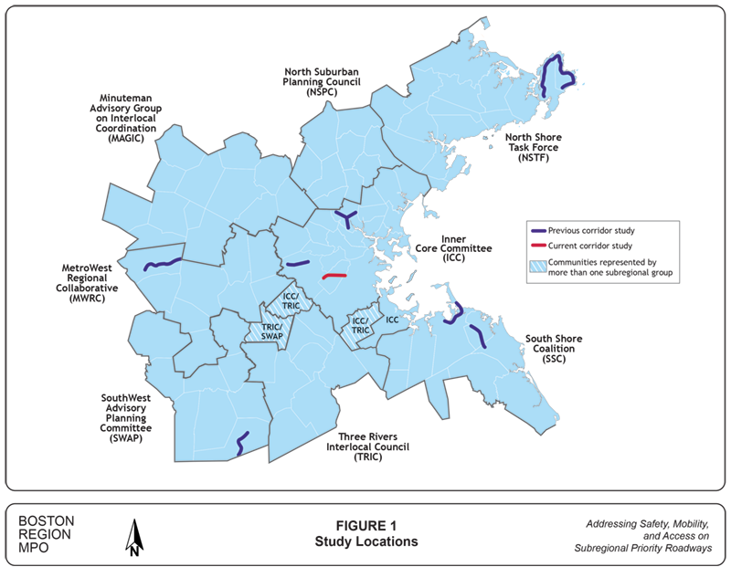
Figure 1 shows the locations of this study and the previously studied corridors in the region. The selected corridor is about three miles in total length. All the segments in the corridor are classified as Urban Principal Arterial. The roadway carries regional and local traffic, pedestrians, bicycles, and MBTA Bus Routes 51 and 60. In addition to residential areas, the corridor contains three major commercial areas, Brookline Village, Route 9 East, and Route 9 Reservoir, and a popular park, Brookline Reservoir Park. The Town of Brookline is currently planning to enhance the vibrancy, design, and livability of the Route 9 corridor through land-use changes and capital improvements. A study of the corridor will be essential to support the plan’s goals by analyzing existing transportation conditions and potential improvements. Meanwhile, it will support enhancement of subregional transportation safety and mobility.
The selected Route 9 corridor in Brookline meets the objectives of this study, especially in supporting the transportation improvement priorities of the Inner Core Committee subregion.
MPO staff will submit this proposal to the MPO for discussion and approval. If the MPO approves this selection, staff will meet with officials from Brookline, MassDOT, and MAPC to discuss the study specifics, conduct field visits, collect data, and perform various analyses.
1 Unified Planning Work Program, Federal Fiscal Year 2019, endorsed by the Boston Region Metropolitan Planning Organization on June 21, 2018.
2 Boston Region MPO Work Program for Addressing Priority Corridors from the Long-Range Transportation Plan Needs Assessment: Federal Fiscal Years 2012–18.
3 HSIP-eligible crash clusters are defined by MassDOT as crash clusters that rank within the top five percent of crash clusters for each Regional Planning Agency, based on the Equivalent Property Damage Only (EDPO) index. In the EDPO index, property-damage-only crashes are awarded one point each, crashes involving injuries are given five points each, and fatal crashes are given 10 points each. In the Boston Region MPO, 939 intersections are identified from MassDOT 2012–14 Crash Data as the top five percent crash clusters with a minimum EDPO value of 41.
4 Pedestrian Level-of-Service Memorandum, Ryan Hicks and Casey-Marie Claude, Boston Region Metropolitan Organization, January 19, 2017.
5 Pedestrian crashes refers to crashes that involve at least one vehicle and one pedestrian, and bicycle crashes refers to crashes involving at least one vehicle and one bicycle. No crashes involving at least one bicycle or one pedestrian were identified from the available data.
TABLE 1 |
||||||||||||||||||||
| Roadway | Location | Community | MAPC Subregion | MassDOT District | Jurisdiction | Length (Miles) | Functional Classification* |
Average Daily Traffic | Overall Crash Rate (MVMT) | Bike/Ped Crashes Per Mile | HSIP-Eligible Crash Clusters 2013-2015 | Study, Project, or TIP Project | Safety Conditions** | Multimodal Significance** | Subregional Priority** | Implement- ation Potential** |
Regional Equity** | Score | Overall Assessment | Summary of Comments |
| Selected for Study: Route 9 | Newton city line to Boston city line | Brookline | ICC | 6 | MassDOT | 3.0 | 2 | 40,000 | 1.2 | 10.7 | 1 | MassDOT Project 605110 (100% design received 6/18/2018): Intersection and signal improvement on Route 9 in the Gateway East or Village Square area of Brookline. The project will revitalize the corridor, improve the livability for residents and businesses, improve regional connections for bicycles and pedestrians and improve the overall streetscape. Major improvement items include (1) realign Walnut Street to Pearl Street to form a new four-way signalized intersection, (2) upgrade the signals at Washington Street and at Brookline Avenue, (3) interconnect the new signals at the three intersections, (4) demolish the pedestrian bridge that is currently closed for safety concerns, and (5) provide separated bicycle lanes. MassDOT Project 608821 (in the preliminary design phase): Resurfacing and related work on Route 9 in Brookline and Newton. |
2 | 2 | 2 | 3 | 0 | 9 | High | Town of Brookline and MassDOT Highway Division District 6 recently proposed this roadway as a study location for FFY 2019 priority corridor study. They cited that the study of traffic operations and transportation conditions of all travel modes would support the town's development plan and enhance the regional transportation safety and mobility. |
| Route 109 | Walpole town line to Interstate 95 | Westwood | ICC | 6 | Westwood | 4.1 | 3 | 16,500 | 4.6 | 2.2 | 2 | TIP 1819 (Pre-TIP FFYs 2019-23): Route 109, High Street traffic operational improvements by the use of Adaptive Signal Control Technology at seven locations from Hartford Street to Lowder Brook Drive. MassDOT Project 608947: Traffic signal improvements on Route 109. This project is in the preliminary design phase. MassDOT Project 601315: Reconstruction of Route 109 (High Street) from Grove Street to Hartford Street. The project proposes to reconstruct High Street, including new traffic signals at Hartford Street, Gay Street, Windsor Road/Public Library entrance, and Summer Street. Construction ended in Spring 2008. |
2 | 2 | 2 | 2 | 0 | 8 | High | In FFY 2016 UPWP outreach, Medfield cited Route 109 as a major commute route to Interstate 95 that puts stain on the adjacent communities. Based on the comment, staff also examined this Westwood section. Route 109 was also mentioned as a major regional travel route in a 2018 SWAP subregional meeting. MassDOT Project 608947 covers a major portion of the corridor. |
| Route 135 | Hopkinton town line to Framingham city line |
Ashland | MWRC | 3 | Ashland | 3.1 | 3 | 12,000 | 3.7 | 2.9 | 0 | No Projects | 2 | 2 | 2 | 1 | 1 | 8 | High | In FFY 2018 MWRC meeting, Route 135 from Hopkinton to Natick was cited as a regional corridor needing Complete Street improvements. |
| Washington Street | Dedham Street to Cobbs Corner | Canton | TRIC | 6 | Canton | 2.5 | 3 | 16,000 | 3.4 | 4.0 | 0 | No projects | 1 | 2 | 2 | 1 | 1 | 7 | Medium | Canton requested a study of the downtown section for signal coordination and pedestrian and bicycle safety and mobility improvements (2015 UPWP outreach). |
| Route 37 | Braintree town line to Brockton town line | Holbrook | SSC | 5 | MassDOT and Holbrook | 3.6 | 3 | 15,500 | 3.5 | 2.2 | 1 | TIP/MassDOT Project 608543: Corridor Improvements and Related Work on South Franklin Street (Route 37) from Snell Street to King Road. The project consists of roadway rehabilitation to provide a consistent cross section, sidewalk reconstruction, ADA compliant curb ramp installation, and drainage upgrades along Route 37 for a length of 0.6 miles. Minor modification to the Route 37/King Road traffic signals is proposed (FFY 2013 Safety and Operations at Intersections). This project is in the preliminary design phase. | 2 | 1 | 2 | 1 | 1 | 7 | Medium | The Town of Holbrook has been in contact with the district and is interested in improvements, particularly multimodal transportation improvements. |
| Route 117 | Weston town line to Route 20 | Waltham | ICC | 4 | Waltham, MassDOT (0.05 mile section to I-95) | 1.3 | 5 | 17,500 | 4.2 | 3.8 | 1 | No projects | 2 | 1 | 2 | 2 | 0 | 7 | Medium | In FFY 2012 UPWP outreach, Waltham proposed this roadway for the Priority Corridor study. Major proposals include widening the bridge over Route 128, connecting Route 2 by extending Green Street, and other critical intersection improvements. In FFY 2016 UPWP outreach, MWRC proposed this corridor as part of a subarea study that includes Route 20 and Route 30 between Waltham and Weston. |
| Route 38 | I-95 Interchange to Wilmington town line | Woburn | NSPC | 4 | MassDOT, Woburn | 1.4 | 3 | 19,250 | 7.5 | 2.1 | 3 | Conceptual (2013) TIP Arterial and Intersection Project #1449 Route 38 (Main Street) Traffic Lights, consisting of replacing outmoded traffic signal controls for the 12 signalized intersections along Route 38 in Woburn |
2 | 1 | 2 | 1 | 1 | 7 | Medium | NSPC and Woburn requested a study of the I-95 rotary interchange and the traffic signals at Route 38 and Elm Street. The area north of I-95 recently reconstructed by adjacent developments. MassDOT District 4 noted high crash locations at Elm Street and at the I-95 Rotary. While a study may have value, they suggested that a RSA may be a more appropriate way to address these locations. |
| Route 35 | Route 97 in Topsfield to Route 114 (Margin Street) in Peabody | Topsfield (less than 0.05 mi), Danvers, Peabody | NSTF | 4 | Topsfield (less than 0.05 mile), Danvers, Peabody, MassDOT | 6.0 | 5 | 17,250 | 1.9 | 1.2 | 1 | Advertised TIP #606609 Bridge Replacement, Route 35 (Water Street) over Waters River MassDOT Project #87612 Reconstruction of Two Interchanges on Route 128, with Route 62 and with Route 35; complete Autumn 2012 |
1 | 2 | 2 | 1 | 1 | 7 | Medium | NSTF cited this roadway during the UPWP outreach for FFYs 2013 and 2014. Verbal comments were made a MAPC subregion meeting and a letter for the FFY 2014 UPWP was submitted. |
| Route 114 | Salem town line to Route 129 (Ocean Ave) | Marblehead | NSTF | 4 | Marblehead | 1.4 | 3 | 16,750 | 2.3 | 3.6 | 0 | No projects | 1 | 1 | 2 | 2 | 1 | 7 | Medium | NSTF cited this roadway during the UPWP outreach for FFYs 2013 and 2014. Study should include how to improve bike facilities and bike-to-rail connections in this heavily traveled tourist area and build on the Essex Coastal Scenic Byway to the region. |
| Route 129 | Lynn town line to Marblehead town line | Swampscott | NSTF | 4 | Swampscott, DCR (less than 0.1 mi) | 2.5 | 3 | 19,000 | 1.8 | 4.4 | 0 | TIP 600989: Reconstruct Route 129 (Humphrey Street) from the Lynn town line to Puritan Road. FFYs 2018-22 Pre-TIP. Community Transportation Technical Assistance Program, CTPS and MAPC Study Conceptual TIP project 972: Atlantic Avenue (Route 129) roadway rehabilitation from Puritan Road and Humphrey Street to the Marblehead town line |
1 | 2 | 2 | 1 | 1 | 7 | Medium | NSTF cited this roadway in 2013 as one of the subregion's priority roadways for study in the 2014 UPWP. Segment in downtown Swampscott is a bottleneck for those traveling from Marblehead to Lynn. MassDOT District 4 noted that the intersection of Route 129 and Burrill Street is a high crash location and an RSA could address safety and congestion issues. |
| Route 135 | West Main Street to Ashland town line | Hopkinton | MWRC | 3 | Hopkinton | 2.6 | 3 | 13,500 | 4.0 | 1.5 | 1 | MassDOT Project 606043 (Signal and Intersection Improvements on Route 135): The project involves intersection improvements at Route 85, Pleasant Street, and Wood Street. Major improvements include signal equipment upgrade and additional lanes at Route 85; possible signalization at Pleasant Street; minor widening, geometric modifications, and equipment upgrades at Wood Street; pavement rehabilitation and drainage improvements from Ash Street to Wood Street; and reconstructed sidewalks and wheelchair ramps, and streetscape enhancements in the town center. The project is currently under design and is programed in 2018–22 TIP. | 1 | 2 | 2 | 1 | 1 | 7 | Medium | In FFY 2018 MWRC meeting, Route 135 from Hopkinton to Natick was cited as a regional corridor needing Complete Street improvements. MassDOT Project 606043 covers a major portion of Route 135 in Hopkinton. |
| Edgell Road | Route 9 to Water Street in Framingham | Framingham | MWRC | 3 | Framingham | 2.2 | 5 | 18,500 | 4.4 | 1.4 | 1 | MassDOT Project 608889: Traffic Signal Installation at Edgell Road and Central Street. This project is in the preliminary design phase. Pre-TIP 602038 Edgell Road Corridor Project: Reconstruct pavement and improve signalization at Water Street, Brook Street, Central Street, and Vernon Street (close to Route 9) No projects in MassDOT project database. |
1 | 2 | 2 | 1 | 1 | 7 | Medium | The roadway was first mentioned in FFY 2008 UPWP outreach and cited in FFY 2018 MWRC meeting. |
| Route 109 | Milford town line to Millis town line | Medway | SWAP | 3 | Medway | 4.8 | 3 | 15,000 | 2.7 | 1.5 | 1 | MassDOT Project 605657: The Route 109 reconstruction project in Medway will focus on roadway improvements in Medway’s business district including resurfacing and reconstruction, consolidating curb cuts, sidewalks, signage, street lighting, and aesthetic improvements. Signal upgrade and capacity improvements will be implemented at the intersection of Main, Franklin, Milford, and Highland streets, including widening for turn lanes in the SB and WB approaches. Work also includes adjusting the grade on Main Street west of Winthrop Street for approximately 700 feet. The project is currently under construction. | 0 | 2 | 2 | 2 | 1 | 7 | Medium | In FFY 2018 UPWP outreach, Route 109 is cited as a major subregional travel route to Interstate 95/Route 128. MassDOT Project 605657 covers a significant portion of Route 109 in Medway. |
| Route 109 | Medway town line to Medfield town line | Millis | SWAP | 3 | Millis | 3.8 | 3 | 16,000 | 1.1 | 0.3 | 0 | No projects | 0 | 2 | 2 | 2 | 1 | 7 | Medium | In FFY 2018 UPWP outreach, Route 109 is cited as a major subregional travel route to I-95/Route 128. |
| Route 109 | Millis town line to Dover town line | Medfield | TRIC | 3 | Medfield | 3.2 | 3 | 16,000 | 2.9 | 1.6 | 0 | MassDOT Project 601654: Roadway reconstruction including signals on a section of Route 109 (Main Street). The project was completed in the summer 2002. No recent projects. | 0 | 2 | 2 | 2 | 1 | 7 | Medium | In FFY 2018 UPWP outreach, Route 109 is cited as a major subregional travel route to I-95/Route 128. |
| Concord Avenue | Blanchard Road to Garden Street | Cambridge | ICC | 6 | Cambridge and DCR (between two rotaries) | 1.9 | 3 and 2 (between two rotaries) | 28,000 | 3.3 | 12.6 | 1 | TIP Conceptual Project #987 Minuteman Path right-of-way to acquire Watertown branch right-of-way to connect Minuteman Path from Arlington, Cambridge, and Watertown to Dr. Paul Dudley White Bike Path in Boston DCR announced a comprehensive study of the parkway system for bike lanes on December 18, 2014 (a small portion of this segment has DCR jurisdiction). |
2 | 2 | 1 | 1 | 0 | 6 | Medium | Comments in survey response on vision, goals, objectives in FFY 2015 LRTP outreach. For example, "eliminate designation of Concord Avenue as 'unrestricted arterial' street. It’s a narrow street with no wiggle room for bicycles when trucks pass." The small DCR portion of this segment is included in the comprehensive DCR study announced December 2014. |
| Route 38 | Woburn town line to Tewksbury town line | Wilmington | NSPC | 4 | MassDOT | 4.0 | 3 | 17,500 | 4.8 | 3.8 | 3 | Pre-TIP/MassDOT Project 608051: Reconstruction on Route 38 (Main Street), from Route 62 to the Woburn city line. The roadway will consist of two 11-foot lanes, two five-foot bike lanes and a six-foot sidewalk. Turn lanes and upgraded traffic signals will be installed at Route 62; preliminary design phase. Pre-TIP/MassDOT Project 607327: Bridge Replacement, Route 38 (Main Street) over the Boston and Marine Corporation Railroad; preliminary design phase. |
2 | 2 | 1 | 0 | 1 | 6 | Medium | Pre-TIP #608051 has a scope covering half of the segment's length (about 2.2 miles). The project is under design. NSPC cited this roadway during the UPWP outreach for FFYs 2013 and 2014. Both Routes 38 and 62 serve as conduits through Wilmington to I-95 and I-93, and contain congested signalized intersections and traffic and pedestrian safety issues. |
| Route 129 | Swampscott town line to Ocean Ave. | Marblehead | NSTF | 4 | Marblehead | 1.5 | 3 | 12,100 | 2.0 | 2.0 | 0 | Conceptual TIP Arterial and Intersection Project 972 Atlantic Avenue (Route 129) ends at the location boundary, near Seaview Avenue in Marblehead |
0 | 2 | 2 | 1 | 1 | 6 | Medium | NSTF cited this roadway as one of the subregion's priority roadways for study in the FFY 2013 and FFY 2014 UPWP. High traffic volumes between Marblehead and Lynn are creating bottlenecks in this corridor. |
| Main Street | Wakefield town line to Central Street | Saugus | ICC | 4 | Saugus and MassDOT | 2.9 | 3, 5 | 16,950 | 3.0 | 2.1 | 4 | No projects |
1 | 2 | 1 | 1 | 1 | 6 | Medium | In FFY 2012 UPWP outreach, Saugus requested the MPO to consider performing a roadway/sidewalk/traffic light/pedestrian access assessment study, to be called a Main Street/Saugus Center Corridor Study. |
| Route 2A (King Street) | Route 495 Southbound ramps to Ayer town line | Littleton | MAGIC | 3 | MassDOT | 2.5 | 3 | 15,000 | 1.8 | 0.4 | 1 | TIP/MassDOT 608443: Intersection Improvements on Route 2A at Willow Road and Bruce Street. The project involves intersection improvements, including geometric modifications, widening, and signalization. Additional improvements involve updated signage and pavement markings. This project is in the preliminary design phase. MassDOT Project 605504: Bridge Betterment, Route 2A (King Street) over I-495; scheduled to complete in 2013. |
1 | 2 | 2 | 0 | 1 | 6 | Medium | Requested by Littleton in 2015. |
| Route 85 | Hopkinton town line to Marlborough city line |
Southborough | MWRC | 3 | Southborough | 4.3 | 5 | 8,000 | 2.3 | 0.0 | 0 | MassDOT Project 600573: Roadway reconstruction and related work on Route 135 (East and West Central Street) and Route 27 (North and South Main Street) in Natick. Project completed in spring 2008. | 0 | 2 | 2 | 1 | 1 | 6 | Medium | In FFY 2018 MWRC meeting, Route 85 (Cordaville Road) was cited as a corridor needing improvements. |
| Route 140 | Mendon town line to Franklin town line | Bellingham | SWAP | 3 | MassDOT | 2.6 | 3 | 10,000 | 4.8 | 1.9 | 0 | No Projects | 1 | 2 | 1 | 1 | 1 | 6 | Medium | In FFY 2018 SWAP post-meeting survey, Bellingham proposed Route 140 (Mechanic Street) from Maple Street to Route 126 for complete Street study. |
| Route 133 | Route 127 in Gloucester to Route 1A in Ipswich | Essex, Gloucester, Ipswich | NSTF | 4 | MassDOT, Essex | 11.0 | 5, 6 | 10,500 | 0.7 | 0.1 | 0 | TIP/MassDOT 605743: Resurfacing and Related Work on Central and South Main Streets. In Ipswich, the project will reconstruct the roadway between Mineral Street and Poplar Street (3,200 feet) to improve the roadway surface. Geometric improvements at intersections and pedestrian crossings will be included. The drainage system is undersized and will be upgraded. 25% design received (04/30/2018). FFYs 2019-23 Pre-TIP. TIP/MassDOT 608596: Superstructure Replacement, E-11-001 (2TV), Route 133 (Main Street) over Essex River Bridge. This project is in the preliminary design phase. FFYs 2018-22 TIP Programmed. MassDOT Project 602146: Resurfacing and Related Work on a Section of Route 133 (Essex Road). The project includes pedestrian improvements from the intersection of Route 1A to the Essex town line, a distance of approximately two miles; completed spring 2011. MassDOT Project 600217: Reconstruction of Route 133 (Main Street) from North of Western Avenue to Waters Street in Essex (about one mile). It includes concrete sidewalks and pavement markings; completed autumn 2013. |
0 | 2 | 1 | 1 | 1 | 5 | Low | MassDOT Project 602146 covers all of the Ipswich portion of the segment, and 600217 covers some of the Essex portion. This roadway was cited in the 2013 UPWP outreach. A two-mile section in the Essex downtown area was reconstructed in summer 2011. |
| Route 97 | Route 1A in Beverly to Topsfield/ Boxford town line | Beverly, Wenham, Topsfield | NSTF | 4 | Beverly, Wenham, Topsfield | 8.9 | 5 | 15,000 | 0.8 | 0.3 | 2 | MassDOT Project 604028: Intersection Improvements on Route 97 (Topsfield Road) at Cherry and Maple Streets; completed 2009. Pre-TIP Project 605020: Border (New Hampshire) to Boston Bikeway intersects Route 97 in Wenham. MassDOT Project 600596: Signal Upgrade of Newburyport Turnpike (Route 1) at High Street (Route 97); completed 2008. |
0 | 2 | 1 | 1 | 1 | 5 | Low | NSTF proposed to study this segment in conjunction with the Route 97 corridor in Boxford, Georgetown, and Haverhill (Merrimack Valley Planning Commission). This may have implementation challenges. Segment mentioned in Fall 2014 LRTP Outreach and Fall 2012 via public comment and a letter for the FFY 2014 UPWP Universe. |
Notes:
* Functional Classification: 2 = principal arterial; 3 = rural minor arterial or urban principal arterial; 5 = urban minor arterial or rural major collector; 6 = urban collector or rural minor collector
** Selection Criteria: Safety Conditions: Location has a high crash rate for its functional class or contains areas with a high number of crashes or with a significant number of pedestrian/bicycle crashes. Multimodal Significance: Location supports transit, bicycle, or pedestrian activity, has significant potential to enhance these activities, or has a heavy vehicle (truck/bus) issue. Subregional Priority: Location carries a significant proportion of subregional vehicle, bicycle, or pedestrian traffic or is essential for its subregional economic, cultural, or recreational development. Implementation Potential: Location is proposed or endorsed by the subregion, by the roadway administrative agency (agencies), or has strong support from all of its stakeholders. Regional Equity: Location is situated in a subregion that has not been selected for this study in the past two years.
Acronyms ADA = Americans with Disabilities Act. CTPS = Central Transportation Planning Staff. DCR = Department of Conservation and Recreation. FFY = Federal fiscal year. HSIP = Highway Safety Improvement Program. ICC = Inner Core Committee. LRTP = Long-Range Transportation Plan. MAGIC = Minuteman Advisory Group on Interlocal Coordination. MAPC = Metropolitan Area Planning Council. MassDOT = Massachusetts Department of Transportation. MVMT = Million vehicle miles traveled. MWRC = MetroWest Regional Collaborative. MPO = Boston Region Metropolitan Planning Organization. NSPC = North Suburban Planning Council. NSTF = North Shore Task Force. RSA = Road Safety Audit. SB = Southbound. SSC = South Shore Coalition. SWAP = South West Advisory Planning Committee. TIP = Transportation Improvement Program. TRIC = Three Rivers Interlocal Council. UPWP = Unified Planning Work Program. WB = Westbound.
Source: Central Transportation Planning Staff.