Technical Memorandum
DATE: November 7, 2019
TO: Boston Region Metropolitan Planning Organization
FROM: Seth Asante, MPO Staff
RE: Selection of FFY 2020 LRTP Priority Corridor Study Location
During the development of the Boston Region Metropolitan Planning Organization’s (MPO) Long-Range Transportation Plan (LRTP), Destination 2040, the MPO staff identified the existing needs for all transportation modes in the region.1 The results were compiled in the LRTP Needs Assessment, which is used to guide the MPO’s decision-making process for selecting transportation projects to fund in future Transportation Improvement Programs (TIPs). The MPO goals that guided the development of the LRTP Needs Assessment include the following:
Based on previous and ongoing transportation-planning work—including the MPO’s Congestion Management Process (CMP) and planning studies—MPO staff identified several priority arterial roadway segments that require maintenance, modernization, and safety and mobility improvements. These locations are documented in the LRTP Needs Assessment.
To address problems on some of these arterial segments, the Addressing Priority Corridors from the Long-Range Transportation Plan Needs Assessment study was included in the federal fiscal year (FFY) 2020 Unified Planning Work Program (UPWP).2 This memorandum presents the results of the selection process and a recommendation for a location to study to the MPO board for discussion.3
By focusing on arterial segments rather than intersections, planners can evaluate multimodal transportation needs comprehensively (with the goal of creating Complete Streets). A holistic approach to analyzing problems and forming recommendations ensures that the needs of all transportation users are considered. Ultimately, this approach will result in roadways where it is safe to cross the street and walk or bicycle to shops, schools, train stations, and recreational facilities, and where buses can run on time. Typically, the recommended improvements are within a roadway’s right-of-way. When developing the recommendations, the needs of abutters and users are taken into account. The interests and support of stakeholders are also considered.
The process for selecting study locations consisted of three steps:
Details about each step in the process are provided below.
MPO staff identified 43 arterial segments in 33 municipalities in the Boston region based on the following data sources:
Table 1 (attached) presents the data and information gathered about each of the arterial segments:
Table 1 also includes the score and priority rating that were determined by applying the selection criteria. The processes for scoring and assigning priority ratings to segments are described below.
MPO staff examined the arterial segments more closely by applying the following six criteria and assigning points based on the number of criteria that apply to each location.
MPO staff rated arterial segments with a total score of 11 or fewer points as low priority; those with a score of 12 to 13 points as medium priority; and those with a total score of 14 or more points as high priority. Staff gave 12 arterial segments a high-priority rating based on safety and operational needs, multimodal and regional significance, regional equity, and support for improvements from agencies and municipalities. Staff then examined high-priority segments more closely and excluded arterials for which there were projects meeting any of the following criteria from further consideration for this cycle of the Priority Corridors study: recently completed, in construction, in design, under study, or programmed in the TIP with the 25 percent design completed.
Staff also evaluated the pedestrian accommodation and safety improvement needs for the segment with the highest score by applying the MPO’s Pedestrian Report Card Assessment and Bicycle Level-of-Service Metric (Bicycle Report Card).4 These locations highly qualify based on pedestrian and bicycle accommodation or safety improvement requirements. Appendix A contains detailed results of the assessments for Route 28 in Milton, the arterial segment with the highest score.
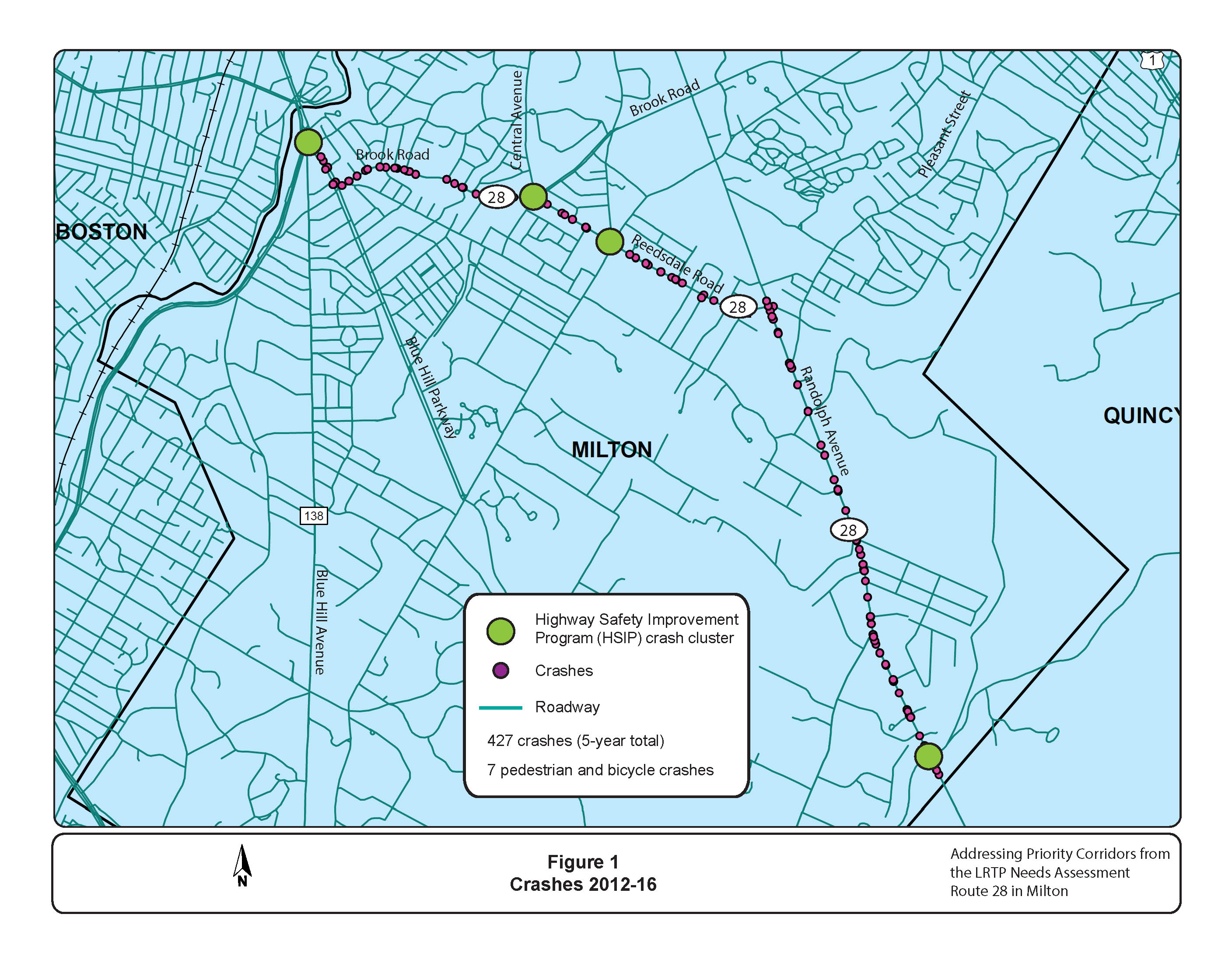
Based on this evaluation, staff recommends studying the segment on Route 28 in Milton. Figure 1 shows the study area with four HSIP intersection crash clusters.
The arterial segment on Route 28 in Milton received a total score of 15, based on five of the six selection criteria (safety, congestion, multimodal and regional significance, regional equity, and implementation potential). Route 28 runs north and south through Milton and it serves residential, educational, and recreational areas, and a medical center. Route 28 also carries commuter traffic to and from Boston. Staff’s evaluation indicates that there are safety, capacity management, and mobility problems in the segment. Four locations along the segment contain HSIP-eligible crash clusters, one of which is in the top 200 of intersection crash clusters in Massachusetts. Also, accommodation for bicyclists is poor and better bicycle connections are needed in the area.
The Town of Milton and the MassDOT Highway Division are looking for solutions to the problems in the corridor and have expressed support for and willingness to participate in a study of this arterial segment (see Appendix B). MPO staff would identify the problems and develop solutions that could be incorporated into MassDOT’s project #609396 for resurfacing and related work on Route 28. The improvements would be implemented by the Town of Milton and MassDOT. The recommended arterial segment meets the selection criteria of this study, especially by supporting the transportation improvement priorities of the MPO’s LRTP.
After the MPO board discusses this recommendation, staff will meet with officials from the Town of Milton and MassDOT and other stakeholders to discuss the study specifics, conduct field visits, collect data, identify needs, and develop solutions.
SA/sa
1 Destination 2040: The New Long-Range Transportation Plan of the Boston Region Metropolitan Planning Organization was adopted by the Boston Region MPO in August 2019.
2 The FFY 2020 Unified Planning Work Program was endorsed by the Boston Region MPO on July 18, 2019.
3 The Boston Region MPO’s work program for Addressing Priority Corridors from the Long-Range Transportation Plan Needs Assessment: Federal Fiscal Year 2020 was approved on September 19, 2019.
4 Ryan Hicks and Casey-Marie Claude, Boston Region Metropolitan Planning Organization, Pedestrian Level-of-Service Memorandum, January 19, 2017; Casey-Marie Claude, Boston Region Metropolitan Planning Organization, Development of a Scoring System for Bicycle Travel in the Boston Region, November 8, 2018.
| TABLE 1 Arterial Segments Considered for Study: Priority Corridors for Long-Range Transportation Plan Needs Assessment Study |
||||||||||||||||||||||
| Arterial Segment | Community | MAPC Subregion | MassDOT District | Jurisdiction | National Highway System | Functional Class* | Number of Top-200 High-Crash Locations 2014–16 | Number of HSIP-Eligible Crash Clusters 2014–16** | Travel Time Index | Transit Service | Crowded or Late Bus | In or Near Transportation Equity Priority Area | Study, Project, or TIP Project | Safety Conditions*** | Congested Conditions*** | Multimodal Significance*** | Regional Significance*** | Regional Equity*** | Implementation Potential*** | Score | Priority Rating | Summary of Comments |
| Route 28 | Milton | ICC and TRIC | 6 | MassDOT and Milton | Yes | 3 | 1 | 4 | 2.48 | MBTA bus Routes 240, 245, 24, 28, 26, 29, 30, 31, and 33 MBTA Red Line rapid transit at Mattapan/Ashmont Station, BAT Route 12 |
Yes | Yes | MassDOT Project #607342, Intersection and Signal Improvements at Route 28 (Randolph Avenue) and Chickatawbut Road; programmed FFY 2020. MassDOT Project #609396, Resurfacing and related work on Route 28, in preliminary design. MassDOT Project # 106901: Reconstruction on Route 28 (Randolph Avenue) from Reedsdale Road to Quincy town line, completed in 2008. |
4 | 2 | 3 | 3 | 0 | 3 | 15 | High | This arterial segment was recommended for study because of safety problems. There are four HSIP intersection clusters in the segment. There is no accommodation for bicycles in the segment, which presents a significant connectivity problem because several of the side streets have bicycle lanes. There are peak period traffic congestion problems that create safety, operations, and mobility issues for the residents. The Town of Milton and MassDOT have expressed their support and will participate in the study. In addition, recommendations from the study could be incorporated into MassDOT Project #609396 or a new project. |
| Route 107 | Salem | NSTF | 4 | MassDOT and Salem | Yes | 3 | 4 | 13 | 2.84 | MBTA bus Routes 450, 456, 459, 461, 465, and 469 MBTA commuter rail at Salem and Beverly Ferry service |
Yes | Yes | Route 107 Corridor Study in Salem and Lynn, completed in 2016. MassDOT Project #608059: Stormwater improvements along Route 107 (Salem Bypass Road), in construction. MassDOT Project #608650: Adaptive Signal Controls on Route 107 (Highland Avenue), in construction. MassDOT Project #608817: Resurfacing and related work on Route 107, programmed FFY 2022 TIP. MassDOT Project #608927: reconstruction of Route 107, in preliminary design. |
4 | 2 | 2 | 4 | 2 | 0 | 14 | High | This arterial segment is not recommended for study. The Route 107 corridor in Lynn and Salem was studied in 2016 and many of the recommendations have advanced into MassDOT projects. Also, there is a FFY 2022 TIP project programmed for the corridor. |
| Route 3A | Burlington | NSPC | 4 | MassDOT | Yes | 3 | 0 | 1 | 1.67 | MBTA bus Routes 350, 351, 352, 353, and 354 travel on or across the segment. | None | Yes | MassDOT Project #608068, will install an adaptive traffic control signal system on Cambridge Street, Middlessex Turnpike, and Burlington Mall Road. The project includes the installation of compatible traffic signal control equipment, video detection, communication devices and software to integrate 11 MassDOT and 16 Town-owned traffic signal locations into one adaptive signal system. The project is in construction. | 3 | 1 | 3 | 4 | 2 | 1 | 14 | High | On this segment, there are no accommodations for bicycles, gaps in sidewalk network, and travel lanes that are very wide (drivers form two lanes in each direction). Land use is mixed along the corridor. There are three MBTA bus routes operating in the corridor. Pedestrian and bicycle crashes have occurred in the corridor. The installation of an adaptive traffic control signal system is underway on Cambridge Street, Middlessex Turnpike, and Burlington Mall Road to integrate 11 MassDOT and 16 Town-owned traffic signal locations into one adaptive signal system. |
| Route 9 | Framingham | MWRC | 3 | MassDOT | Yes | 2 | 2 | 7 | 3.47 | MWRTA Routes 1, 2, 3, 7, and 9 | None | Yes | MassDOT Project #604991: Resurfacing and Related Work on Route 9, includes wheelchair ramp upgrades, additional sidewalks/repairs, and signal improvements; completed in autumn 2011. MassDOT Project #608006: Framingham--Pedestrian Hybrid Beacon Installation at Route 9 and Maynard Road and the Framingham Fire Station, in design. MassDOT Project #608281: Installation of adaptive traffic control signal equipment, vehicle detection, communication equipment, and managing software at 5 traffic signals (3 in Framingham and 2 in Natick) on Route 9, in construction. MassDOT Project #608836: Drainage improvements on Route 9 at Route 126 interchange and salt shed relocation (Phase 1). |
3 | 2 | 2 | 4 | 2 | 1 | 14 | High | This arterial segment was not selected because, according to MassDOT District 3, most of the intersections on this corridor have already been studied and there are several MassDOT projects under construction in the corridor. |
| Route 135 | Framingham | MWRC | 3 | Framingham | Yes | 3 | 1 | 4 | 1.63 | MBTA commuter rail at Framingham. MWRTA Routes 4, 5, 6, and 11 |
Yes | MassDOT Project #606109: Intersection improvements at Route 126/135/MBTA and CSX railroad. | 4 | 1 | 2 | 4 | 2 | 1 | 14 | High | MassDOT Project #606109: Intersection improvements at Route 126/135/MBTA and CSX railroad. Roadway has received improvements to address congestion and make it multimodal (accommodation for pedestrians and bicycles). | |
| Route 16 | Medford | ICC | 4 | MassDOT | Yes | 2, 3 | 1 | 5 | 3.04 | MBTA bus Routes 90, 97, 99, 100, 106, 108, 110, 112, and 134 MBTA rapid transit on the Orange Line at Wellington and on the Red Line at Porter Square; MBTA commuter rail at West Medford and Porter Square |
Yes | Yes | MassDOT Project #604660: Everett--Medford-Bridge Replacements, Revere Beach Parkway (Route 16), E-12-004=M-12-018 over the Malden River (Woods Memorial Bridge) and M-12-017 over MBTA and Rivers Edge Drive—The purpose of this project is to replace the existing non-operating draw bridge with a new fixed bridge. The project is under construction. MassDOT Project #605531: Structure maintenance, E-12-004=M-12-018, Revere Beach Parkway (Route 16) over the Malden River (Woods Memorial Draw Bridge), in construction. |
3 | 2 | 3 | 4 | 0 | 2 | 14 | High | In FFY 2019, MPO staff studied Route 16 in Chelsea and Everett and suggested improvements to address safety, congestion, multimodal transportation, pedestrian and bicycle accommodations. The section of Route 16 in Medford has five HSIP intersection clusters, including two pedestrian clusters. The roadway experiences congestion and high truck volumes. It is also carries vehiclular, pedestrian, and bicycle traffic to Wellington Station. Studying this segment in Medford will provide MassDOT with improvement concepts to comprehensively address safety, capacity management and mobility, and pedestrian and bicycle accommodations in the corridor. |
| Route 16 | Milford | SWAP | 3 | MassDOT and Milford | Yes | 3 | 0 | 5 | 3.58 | MWRTA Route 14 | Yes | MassDOT Project #607428: Resurfacing and intersection improvements on Route 16 (Main Street), from Water Street west to approximately 120 feet west of the Milford/Hopedale town line and the intersection of Route 140; programmed FFY 2019. MassDOT Project #606142: Signal and intersection improvements on Route 16 (Main Street and East Main Street) at six locations; completed in 2013. |
3 | 2 | 2 | 4 | 2 | 1 | 14 | High | This corridor is not recommended for study. The corridor received improvements in 2013 based on a CTPS study and currently a MassDOT resurfacing and intersection improvement project has been programmed for FFY 2019. | |
| Route 114 | Salem | NSTF | 4 | MassDOT and Salem | Yes | 2, 3 | 0 | 3 | 2.06 | MBTA bus Routes 450, 451, 455, 456, 459, and 465 MBTA commuter rail at Salem and Beverly; Ferry service |
Yes | Yes | MassDOT Project #608521; Bridge Maintenance, North Street (Route 114) over Bridge Street (Route 107) and MBTA, in construction. MassDOT Project #605332, Bridge Replacement (Route 114) North Street over North River; in preliminary design. |
3 | 2 | 2 | 4 | 2 | 1 | 14 | High | This roadway has Complete Streets improvements, including sidewalks and bicycle lanes on either side of the roadway. The section that requires improvements to improve safety, capacity management and mobility, and accommodate bicycles is between Bridge Street (Route 107) and Route 128. |
| Route 16 | Wellesley | MWRC | 6 | MassDOT and Wellesley | Yes | 3 | 0 | 5 | 2.57 | MBTA commuter rail at Wellesley Square, Wellesley Hills, Wellesley Farms and Waltham | N/A | Yes | MassDOT Project #94762: Bridge Rehabilitation, Br# W-13-014 Route 16 (Washington Street) over Route 9 including relocation of retaining wall. | 3 | 2 | 2 | 4 | 2 | 1 | 14 | High | The location was suggested in 2014 LRTP outreach through verbal comments at a 495/MetroWest Partnership meeting. |
| Route 20 | Weston | MWRC | 6 | MassDOT | Yes | 3 | 0 | 3 | 3.06 | MBTA bus Route 70 MBTA commuter rail at Waltham and Kendal Green |
Yes | Yes | Intersection improvements on Boston Post Road (Route 20) at Wellesley Street; preliminary design stage. | 2 | 2 | 2 | 4 | 2 | 2 | 14 | High | A congestion study was suggested through UPWP and LRTP outreach in 2012, 2013, and 2014 by MAGIC; a formal letter was submitted and verbal comments were made at an MWRC subregion meeting. A suggestion to study this location was resubmitted in a comment on the Draft FFY 2014 UPWP and during the 2017 MPO outreach program. |
| Route 18 | Weymouth | SSC | 6 | MassDOT | Yes | 3 | 3 | 9 | 2.55 | MBTA bus Route 225 MBTA commuter rail at South Weymouth |
Yes | Yes | MassDOT Project #601630—Reconstruction and widening on Route 18 (Main Street) from Highland Place to Route 139 (4.0 miles) includes replacing W-32-013, Route 18 over the Old Colony Railroad (MBTA); in construction. | 4 | 2 | 2 | 4 | 2 | 0 | 14 | High | This arterial segment was not selected because a MassDOT project, currently in construction, would address problems in the entire segment and no study is needed at this time. |
| Routes 38/129 | Wilmington | NSPC | 4 | MassDOT and Wilmington | Yes | 3 | 0 | 4 | 3.31 | MBTA commuter rail at Wilmington, North Wilmington, Anderson/Woburn, and Reading | N/A | Yes | MassDOT Project #608051, Reconstruct Route 38 from Route 62 to the Woburn city line, add bike lanes, sidewalks, and turn lanes, and upgrade signals; in design. MassDOT Project #609253, Intersection improvements at Lowell Street (Route 129) and Woburn Street; in design. MassDOT Project #601732, Rehabilitation, Route 129 (Lowell Street) from Route 38 (Main Street) to Woburn Street; completed in 2009. |
3 | 2 | 2 | 4 | 2 | 1 | 14 | High | Several sections of the arterial have projects that are currently in design. These MassDOT projects would address problems in the corridor. |
| Route 2A/3 | Arlington | ICC | 4 | Arlington | Yes | 3 | 0 | 2 | 2.39 | MBTA bus Routes 67, 77, 79, 80, 87, and 350 travel on or across the segment. | Yes | Yes | None | 3 | 2 | 3 | 4 | 0 | 1 | 13 | High | None |
| Route 203 | Boston | ICC | 6 | MassDOT | Yes | 3 | 5 | 9 | 2.94 | MBTA bus Routes 14,26, 201, 202, 215, and 217 travel on or across the segment. | Yes | MassDOT Project #606318 , Intersection improvements at Gallivan Boulevard (Route 203) and Morton Street; in construction. MassDOT Project #608755, Intersection improvements Morton Street (Route 203) at Blue Hill Ave, at Courtland Road/Havelock Street, and at Havard Street; programmed in the FFY 2019 TIP, in design. MassDOT Project #606896, Reconstruction on (Route 203) Gallivan Boulevard, from Neponset Circle to east of Morton Street intersection; in preliminary design. MassDOT Project #606897, Improvements on (Route 203) Morton Street, from west of Gallivan Boulevard to Shea Circle; in preliminary design. |
4 | 2 | 2 | 4 | 0 | 1 | 13 | High | The FFY 2012 Priority Corridors for LRTP Needs Assessment Study and several MassDOT projects in the corridor will address issues. | |
| Route 37 | Braintree | SSC | 6 | MassDOT | Yes | 2 | 0 | 2 | 2.73 | MBTA bus Routes 230 and 236 and travel on or across the segment. | Yes | MassDOT Project #608651, Adaptive traffic signal control on Route 37 (Granite Street). Installation of adaptive traffic control signal equipment, vehicle detection, communication equipment, and managing software at seven traffic signals on Route 37; in construction. MassDOT Project #607684, Bridge replacement, B-21-017, Washington Street (Route 37) over MBTA/CSX railroad; preliminary design. |
2 | 2 | 2 | 4 | 2 | 1 | 13 | High | The arterial segment has a 5- to 6-foot shoulder on either side of the roadway for most of the corridor. There are sidewalks on either side of the rodeway throughout the corridor. In addition, MassDOT is installing adaptive traffic control signal equipment, vehicle detection, communication equipment, and managing software at seven traffic signals on Route 37, a project that is under construction. | |
| Route 2A | Cambridge | ICC | 6 | Cambridge and DCR | Yes | 3 | 1 | 14 | 2.05 | MBTA bus Routes 67, 77, 79, 80, 87, and 350 travel on or across the segment. | Yes | None | 4 | 2 | 2 | 4 | 0 | 1 | 13 | High | None | |
| Route 2 | Concord | MAGIC | 4 | MassDOT | Yes | 2 | 0 | 1 | 5.93 | MBTA commuter rail at West Concord, Concord, and Lincoln | N/A | Yes | MassDOT Project #602984, Crosby's Corner (Route 2 at Route 2A) Improvements; in construction. MassDOT Project #608015, Reconstruction and widening on Route 2, from Sandy Pond Road to Bridge over MBTA/B&M railroad. MassDOT Project #602091, Concord Rotary; in preliminary design. MassDOT Project #604069, Bridge Replacement over Sudbury River; in preliminary design. MassDOT Project #606223: Bruce Freeman Rail Trail Construction (Phase II-B) in Acton and Concord, will connect the trail across Route 2; programmed in the FFY 2019 TIP, in design. |
2 | 2 | 2 | 4 | 2 | 1 | 13 | High | FFY 2013 Priority Corridors for LRTP Needs Assessment Study (Concord and Lincoln) Route 2 was suggested during MPO outreach as a route experiencing congestion that affects MAGIC communities as well as Cambridge. There are many projects and studies conducted for this corridor, including the Route 2 (Crosby's Corner) improvements and Concord Rotary upgrade and improvements. |
| Route 16 | Holliston | MWRC | 3 | MassDOT and Holliston | Yes | 3 | 0 | 2 | 1.76 | MWRTA Routes 6 and 14 | None | Yes | 2011 CTPS study, Route 126 Corridor: Transportation Improvement Study. 2008 CTPS study, Washington Street (Route 16/126) at Hollis Street. |
2 | 1 | 2 | 4 | 2 | 2 | 13 | High | This location has MassDOT projects and CTPS studies, which have not been implemented. The 495/MetroWest Partnership expressed interest in a Route 16 study. The section that experiences the most crashes is the town center portion (under Holliston jurisdiction). A road safety audit was performed for the town center portion in December 2012. |
| Route 107 | Lynn | ICC | 4 | MassDOT and Lynn | Yes | 3 | 4 | 13 | 1.87 | MBTA bus Routes 424,426, 435, 436, 441, 442, 450, 455, 456, 459, 429, and 435 MBTA commuter rail at River Works, Lynn/Central Square, and Swampscott Ferry service |
Yes | Yes | MassDOT Project #808817: Resurfacing of Route 107 and related improvements; progammed FFY 2022. MassDOT Project #608927, Reconstruction of Route 107 in Lynn and Salem; in preliminary design. MassDOT project #609246, Rehabilitation of Western Avenue (Route 107); in preliminary design. MassDOT Project #604952, Bridge Replacement, Route 107 over the Saugus River; programmed 2019. MassDOT Project #26710, Bridge Replacement, Route 107 over the Saugus River (Fox Hill Bridge); completed spring 2013. |
4 | 1 | 3 | 4 | 0 | 1 | 13 | High | This arterial segment was not selected for study because a Route 107 Corridor Study in Lynn and Salem has been completed by MassDOT recently and the proposed improvements would be addressed under project #608927, which is in design. |
| Route 114 | Peabody | NSTF | 4 | MassDOT and Peabody | Yes | 3 | 0 | 2 | 3.60 | MBTA bus Routes 435, 465 |
Yes | Yes | MassDOT Project # 608567, Improvements at Route 114 at Sylvan Street, Cross Street, Northshore Mall, Loris Road, Route 128 Interchange, and Esquire Drive; programmed FFY 2022. | 3 | 2 | 2 | 3 | 2 | 1 | 13 | High | Route 114 in Peabody was listed as a potential corridor in need of signal progression and improvements to accommodate pedestrians and bicyclists. However, the arterial segment was not selected because, according to MassDOT Highway District 4, a road safety audit was completed for the segment in August 2016 and a consultant has started design work as part of project #608567, which is programed for FFY 2022. |
| Route 3A | Quincy | ICC | 6 | MassDOT, DCR, and Quincy | Yes | 3 | 1 | 10 | 2.76 | MBTA bus Routes 201, 202, 210, 211, 212, 214, 216, 225, and 217 MBTA Red Line rapid transit at Quincy Center MBTA commuter rail at Quincy Center |
Yes | Yes | MassDOT Project #608569, Intersection improvements at Route 3A (Southern Artery) and Broad Street; programmed FFY 2022 TIP. MassDOT Project #605729, Intersection and signal improvements at Hancock Street and East/West Squantum streets; completed in 2015. An FFY 2012 CTPS safety and operations study addressed problems at the Route 3A and Coddington Street intersection. |
4 | 2 | 2 | 4 | 0 | 1 | 13 | High | Route 3A (Hancock Street and Southern Artery) has received several improvement projects and was the focus of a CTPS study. The location was suggested in the 2017 MPO outreach program. |
| Route 1A | Salem | NSTF | 4 | MassDOT and Salem | Yes | 2 | 0 | 9 | 1.59 | 16 MBTA bus stops MBTA bus Routes 455 and 459 MBTA commuter rail at Salem Ferry service |
Yes | Yes | MassDOT Project #605146: Reconstruction of Canal Street from Washington Street and Mill Street to Loring Avenue (Route 1A) and Jefferson Street; completed in 2018. MassDOT Project #601017: Reconstruction of Route 1A (Bridge Street) from the Beverly/Salem Bridge to Washington Street (6,000 feet); completed in 2013. |
3 | 1 | 2 | 4 | 2 | 1 | 13 | High | This arterial segment was not selected because the southern end of this arterial segment is included in the study of Route 1A at Vinnin Square in Marblehead and in Swampscott; this location was selected as the subject of the FFY 2016 Priority Corridors Study. The intersection of Route 1A and Jefferson Street and Canal Street was reconstructed in 2018. |
| Route 16 | Sherborn | SWAP | 3 | Sherborn | Yes | 3 | 0 | 2 | 3.20 | None | N/A | Yes | None | 2 | 2 | 1 | 4 | 2 | 2 | 13 | High | This location was suggested during 2014 LRTP outreach at a 495/MetroWest Partnership meeting. The section that experiences the most crashes and congestion is in the town center, where Route 16 and Route 27 combine and split. |
| Route 3A | Weymouth | SSC | 6 | MassDOT | Yes | 3 | 0 | 1 | 1.74 | 30 MBTA bus stops MBTA bus Routes 220, 221, and 222 MBTA commuter rail at Quincy Center, Weymouth Landing/East Braintree, and West Hingham Ferry service |
Yes | Yes | MassDOT Project #608231, Reconstruction of Route 3A including pedestrian and traffic signal improvements; in design. MassDOT Project #604382, Route 3A (Washington Street) Bridge; in construction. MassDOT Project #608483, Work consists of resurfacing on Route 3A; in preliminary design. |
2 | 2 | 2 | 4 | 2 | 1 | 13 | High | A road safety audit was completed for Route 3A in Weymouth in September 2016. The audit identified the problems and needs on the roadway, and suggested short-, medium-, and long-term improvements. MassDOT Project #608321, in design, will address problems and needs identified in the corridor. |
| Route 60 | Arlington | ICC | 4 | Arlington | Yes | 3 | 0 | 1 | 3.92 | MBTA bus Routes 67, 77, 79, 80, 87, and 350 travel on or across the segment | Yes | Yes |
CTPS and MAPC Community Transportation Technical Assistance Program evaluated the high-crash location at the intersection at Massachusetts Avenue in March 2010. MassDOT Project #606885 reconstructed the intersection of Route 3 and Route 60; the project was completed in 2017. |
3 | 2 | 3 | 3 | 0 | 1 | 12 | Medium | None |
| Route 2/3/3A/16 | Cambridge | ICC | 6 | DCR | Yes | 2 | 3 | 5 | 4.80 | MBTA bus Routes 75, 71, 72, 73, 74, and 78 MBTA Red Line rapid transit MBTA commuter rail at Porter Square |
Yes | Yes | DCR announced that the agency will conduct a traffic study of several intersections along Mount Auburn Street and Fresh Pond Parkway, in partnership with the City of Cambridge and the MBTA. The study will focus on safety measures, bus prioritization, and accessibility. MassDOT Project #608806, Multi-use Path Contruction (Phase II), will create a multi-use greenway on the former B&M railroad right-of-way extending from Concord Avenue in Cambridge through the Fresh Pond Reservation, under Huron Avenue and Mount Auburn Street and into Watertown; this project is in construction. MassDOT Project #609290, Intersection improvements at Fresh Pond Parkway/Gerrys Landing Road, fron Brattle Road to Memorial Drive. |
3 | 2 | 2 | 4 | 0 | 1 | 12 | Medium | The Fresh Pond Residents Alliance identified Fresh Pond Parkway and Alewife Brook Parkway as locations in need of transportation improvements. Concerns include pedestrian safety, particularly for young students who walk to Shady Hill School, because of high traffic volumes, environmental issues, and lack of livability. |
| Route 16 | Chelsea and Everett | ICC | 4 | MassDOT | Yes | 2 | 6 | 7 | 1.99 | MBTA bus Routes 97, 99, 106, 110, 112, 104, 105, and 109 MBTA Orange Line rapid transit at Wellington and MBTA commuter rail at Chelsea |
Yes | Yes | FFY 2019 Priority Corridor for LRTP Needs Assessment Study (Chelsea and Everett) | 3 | 1 | 3 | 4 | 0 | 1 | 12 | Medium | FFY 2019 Priority Corridors for LRTP Needs Assessment Study (Concord and Lincoln) |
| Route 99 | Everett | ICC | 4 | Everett | Yes | 3 | 0 | 1 | 2.23 | MBTA bus Routes 97, 99, 104, 105, 106, 109, 110, and 112 travel on or across the segment |
Yes | Yes | MassDOT Project #602383 reconstructed Route 99 with a traffic signal upgrade, from Second Street to the Malden city line; completed in 2008. MassDOT Project #602382 reconstructed Route 99 from Sweetser Circle to the Alford Street Bridge in 2013; completed spring 2013. |
2 | 2 | 3 | 4 | 0 | 1 | 12 | Medium | This roadway is not recommended for study because MassDOT completely reconstructed Route 99 with signal improvements from Alford Street Bridge to the Malden city line. Route 99 (Lower Broadway) has also received improvements, including pedestrian and bicycle accommodation, as a result of the Encore Boston Harbor mitigation improvements. |
| Route 3A | Hingham | SSC | 5 | MassDOT | Yes | 3 | 0 | 1 | 1.69 | MBTA commuter rail at Cohasset, Nantasket Junction, West Hingham, and East Weymouth Ferry service MBTA bus Routes 220 and 221 |
N/A | Yes | MassDOT Project #605168, Improvements on Route 3A from Otis Street/Cole Road including Summer Street and rotary; Rockland Street to George Washington Boulevard; in preliminary design. MassDOT Project #603137, Intersection Improvements on Route 3A at Kirby Street. There has been local interest in installing a traffic signal at this intersection; in preliminary design. |
2 | 1 | 2 | 4 | 2 | 1 | 12 | Medium | In FFY 2015, a subregional priority roadway study was conducted for Route 3A in Hingham and Hull. The location received strong support from the Towns of Hingham and Hull, as well as the South Shore Coalition and the MassDOT Highway Division District 5 Office. |
| Route 1 | Norwood | TRIC | 5 | MassDOT | Yes | 3 | 0 | 3 | 3.85 | MBTA commuter rail at Islington, Dedham Corp. Center, Endicott, Norwood Depot, Norwood Central, Windsor Gardens, and Plimptonville | N/A | Yes | MassDOT's I-95 South Corridor Study, provided a comprehensive evaluation of the I-95 and Route 1 corridors south of Route 128 that included a recommended plan of short-term and long-term improvements; June 2010. MassDOT Project #609371, Median jersey barrier and fencing upgrade; programmed FFY 2019. MassDOT Project #608052, Route 1 at Morse Street (approved by PRC November 2014); programmed FFY 2023. MassDOT Project #605857, Route 1 at University Avenue and Everett Street; programmed FFY 2022. MassDOT Project #605321, Bridge Preservation, Route 1 over the Neponset River; in design stage. MassDOT Project #606545, Median jersey barrier and fencing upgrade; completed in 2012. |
2 | 2 | 3 | 4 | 0 | 1 | 12 | Medium | The location has MassDOT projects and studies and it is not recommended for study. |
| Route 28 | Randolph | TRIC | 6 | MassDOT and Randolph | Yes | 3 | 3 | 6 | 2.00 | MBTA bus Routes 240 and 238 MBTA commuter rail at Holbrook/Randolph BAT Route 12 |
Yes | Yes | MassDOT Project #609399, Resurfacing and related work on Route 28; in preliminary design. Arterial Coordination Study, CTPS study (2010). |
3 | 2 | 2 | 4 | 0 | 1 | 12 | Medium | The location has received several MassDOT projects and CTPS studies and it is not recommended for study. |
| Route 16 (Revere Beach Parkway) | Revere | ICC | 4 | MassDOT | Yes | 2 | 0 | 1 | 2.93 | MBTA bus Routes 110, 116, and 117 travel on or across the segment MBTA rapid transit on Blue Line MBTA commuter rail at Chelsea |
Yes | Yes | None | 2 | 2 | 3 | 4 | 0 | 1 | 12 | Medium | This location is not recommended for study because the Sufflok Downs Redevelopment project is evaluating several scenarios that would affect traffic on Route 16 and Route 1A. |
| Route 20 | Waltham | ICC | 6 | MassDOT and Waltham | Yes | 3 | 0 | 9 | 2.45 | MBTA bus Routes 70, 170, 505, and 506 travel on or across the segment. | Yes | Yes | City of Waltham Transportation Master Plan, January 2017. | 3 | 2 | 2 | 4 | 0 | 1 | 12 | Medium | This location is not recommended for study because this location had been studied and improvements proposed in the Waltham Transportation Master Plan. |
| Route 9 | Wellesley | MWRC | 6 | MassDOT | Yes | 2 | 0 | 2 | 1.77 | MBTA commuter rail at Wellesley Hills and Wellesley Farms MWRTA bus Route 1 |
None | Yes | MassDOT Project #608180: Resurfacing on Route 9, from limit of add-a-lane to east of Overbrook intersection; in construction. MassDOT Project #606530: Drainage improvements along Route 9 Boulder Brook Culvert (design only); in design. MassDOT Project #607340: Resurfacing and related work on Route 9 from Dearborn Street to Natick town line; in preliminary design. MassDOT Project #609402: Resurfacing and related work on Route 9; in preliminary design. MassDOT Project #94762, Bridge Rehabilitation, Route 16 (Washington Street) over Route 9, including relocation of retaining wall; completed summer 2010. MAPC Land Use/Corridor Study (fall 2013). |
2 | 1 | 2 | 4 | 2 | 1 | 12 | Medium | MassDOT has completed a preliminary assessment of this corridor that will develop into 25 percent design plans for roadway improvements. |
| Route 117 | Bolton | MAGIC | 3 | Bolton | 0 | 0 | 1.70 | None | Yes | None | 2 | 1 | 2 | 3 | 2 | 1 | 11 | Medium | None | |||
| Route 62 | Concord | MAGIC | 4 | Concord | Yes | 3 | 0 | 1 | 2.65 | MBTA commuter rail at Concord and West Concord | N/A | Yes | MassDOT Project #604646 Reconstruction of Main Street (Route 62) from Water Street to the Acton town line; completed 2010. | 2 | 2 | 2 | 2 | 2 | 1 | 11 | Medium | None |
| Route 60 | Medford | ICC | 4 | Medford | No | 3 | 0 | 3 | 3.00 | MBTA bus Routes 95, 101, 194, 134, 326, and 710 MBTA commuter rail at West Medford and Porter Square |
Yes | None | 3 | 2 | 3 | 2 | 0 | 1 | 11 | Medium | None | |
| Route 138 | Milton | ICC and TRIC | 6 | MassDOT | Yes | 2 | 0 | 2 | 2.41 | MBTA bus Routes 245 and 716 MBTA commuter rail at Route 128 Station MBTA Red Line rapid transit at Mattapan Station |
Yes | Yes | MassDOT Project #608484, Roadway Improvements on Route 138, is planned to be funded through the Boston Region Metropolitan Planning Organization's FFY 2020 Transportation Improvement Program; the project will also incorporate work planned originally for Project #607763 (described below); programmed FFY 2020. FFY 2018 LRTP Priority Corridor Study |
2 | 2 | 2 | 4 | 0 | 1 | 11 | Medium | FFY 2018 Priority Corridors for LRTP Needs Assessment Study (Canton). MassDOT Project #608484, Roadway Improvements on Route 138 , programed for FFY 2020, will address problems and needs in the corridor. |
| Route 135 | Natick | MWRC | 3 | MassDOT and Natick | Yes | 3 | 0 | 3 | 1.97 | MWRTA bus Routes 10 and 11 MBTA commuter rail at Natick and West Natick |
None | Yes | MassDOT Project #600573 reconstructed Route 135 in Natick in 2008. More extensive improvements were proposed in the downtown area, on East Central Street between North Main Street and Union Street, including signal upgrades, new sidewalks, pavement rehabilitation, and shoulders; Contract #32302 was completed; all construction operations were suspended (as of June 30, 2007). 2010 CTPS study, West Central Street (Route 135) at Speen Street. |
3 | 1 | 2 | 2 | 2 | 1 | 11 | Medium | There is congestion in the downtown area. The likely focus area would be on the intersection of Route 135 at Route 27 and the intersection of Route 135 at Speen Street because of the crash history of those locations. |
| Route 9 | Newton | ICC | 6 | MassDOT | Yes | 2 | 0 | 3 | 4.98 | MWRTA Route 1 MBTA bus Routes 60, 51, 52, and 59 travel on or across the segment MBTA Green Line |
Yes | Yes | MassDOT Project #608821, Resurfacing and related work on Route 9; in preliminary design. MassDOT Project #604327, Resurfacing and Related Work on Route 9 (Boylston Street) from the Wellesley/Newton city line to Newton/Brookline city line; completed in summer 2012. MassDOT Project #606635, Reconstruction of Highland Avenue, Needham Street, and Charles River Bridge, from Webster Street to Route 9; programmed FFY 2019. |
2 | 2 | 2 | 4 | 0 | 1 | 11 | Medium | According to MassDOT District 6, improvements were recently made to accommodate new developments. An analysis of the new existing conditions would be helpful to compare with the future projected conditions. |
| Route 129 | Reading | NSPC | 4 | MassDOT and Reading | Yes | 3 | 0 | 0 | 1.82 | MBTA bus Route 136 MBTA commuter rail at Wakefield, Reading, and Woburn |
Yes | Yes | No projects | 3 | 1 | 2 | 2 | 2 | 1 | 11 | Medium | None |
| Route 1 | Walpole | TRIC | 5 | MassDOT | Yes | 3 | 0 | 2 | 1.53 | MBTA commuter rail at Sharon and Walpole | N/A | Yes | MassDOT's I-95 South Corridor Study presented a comprehensive evaluation of the I-95 and Route 1 corridors south of Route 128 and included a recommended plan of short-term and long-term improvements; June 2010. MassDOT Project #608480, Resurfacing and related work on Route 1; programmed FFY 2020. MassDOT Project #608599, Stormwater Improvements to treat discharges from Route 1, I-95, and Route 1A to the Neponset River and an Unnamed Tributary; programmed FFY 2022. |
2 | 1 | 3 | 4 | 0 | 1 | 11 | Medium | The location has MassDOT projects and studies and was not recommended for study by MassDOT Highway District 5. |
| Route 1 | Westwood | TRIC | 6 | MassDOT | Yes | 3 | 0 | 0 | 3.49 | MBTA commuter rail at Islington | N/A | Yes | MassDOT's I-95 South Corridor Study provided a comprehensive evaluation of the I-95 and Route 1 corridors south of Route 128 and included a recommended plan of short-term and long-term improvements; June 2010. MassDOT Project #603162, Route 128 Add-a-Lane Bridges (Bridge III), Route 1 and 1A over I-95/128; completed in 2012. |
2 | 2 | 2 | 4 | 0 | 1 | 11 | Medium | This segment is the subject of MassDOT projects and studies. |
| Notes: | ||||||||||||||
| *Functional Class 2 = principal arterial. 3 = principal arterial other (rural minor arterial or urban principal arterial). 5 = minor arterial (urban minor arterial or rural major collector). |
||||||||||||||
| **Number of HSIP-eligible crash clusters HSIP-eligible crash clusters are defined by MassDOT as crash clusters that rank within the top five percent of crash clusters for each regional planning agency, based on the Equivalent Property Damage Only (EDPO) index. In the EDPO index, property damage only crashes are awarded one point each, crashes involving injuries are given five points each, and fatal crashes are given 10 points each. In the Boston region, the 896 intersections in the top five percent have crash clusters with a minimum EDPO value of 42. |
||||||||||||||
| ***Selection Criteria Safety Conditions: Segment has a high crash rate for its functional class, contains an HSIP-eligible crash location, a top-200 high-crash location, and/or a significant number or HSIP-eligible clusters of pedestrian or bicycle crashes. Congested Conditions: Segment has a Travel Time Index of at least 1.3 and/or of at least 2.0, that is, which signify that it experiences delays during peak periods. Multimodal Significance: Segment supports transit or bicycle or pedestrian activities, has a need to improve these activities, and/or has a high volume of truck traffic serving regional commerce. Regional Significance: Segment is in the National Highway System, carries a significant proportion of regional traffic, lies within 0.5 miles of environmental justice transportation analysis zones, and/or is essential for regional economic, cultural, or recreational development in the area. Regional Equity: Location is in a subregion that has not had a priority corridor study before, or location is in a subregion that has not had a priority corridor study in the in last three years. Implementation Potential: Improvements to the segment are proposed or endorsed by the roadway administrative agency (agencies), proposed or endorsed by the subregion and are a priority for the subregion, and/or have strong support from other stakeholders. |
||||||||||||||
| Acronyms ADA = Americans with Disabilities Act. BAT = Brockton Area Transit Authority. CTPS = Central Transportation Planning Staff. DCR = Department of Conservation and Recreation. DEIR = Draft Environmental Impact Report. EJ = environmental justice. FFY = federal fiscal year. GATRA = Greater Attleboro Taunton Regional Transit Authority. HSIP = Highway Safety Improvement Program. ICC = Inner Core Committee. LRTP = Long-Range Transportation Plan. MAGIC = Minuteman Advisory Group on Interlocal Coordination. MAPC = Metropolitan Area Planning Council. MassDOT = Massachusetts Department of Transportation. MBTA = Massachusetts Bay Transportation Authority. MPO = Boston Region Metropolitan Planning Organization. MWRC = MetroWest Regional Collaborative. MWRTA = MetroWest Regional Transit Authority. NSPC = North Suburban Planning Council. NSTF = North Shore Task Force. PRC = MassDOT Project Review Committee. SSC = South Shore Coalition. SWAP = South West Advisory Planning Committee. TIP = Transportation Improvement Program. TRIC = Three Rivers Interlocal Council. UPWP = Unified Planning Work Program. VHB = Vanasse, Hangen, Brustlin Inc. |
||||||||||||||
| Source: Central Transportation Planning Staff. | ||||||||||||||