DRAFT— Amendment One to Destination 2040
The Boston Region Metropolitan Planning Organization (MPO) is proposing an amendment to its current Long-Range Transportation Plan (LRTP), Destination 2040, whichwas endorsed by the MPO in August 2019. This document explains the proposed amendment, whose primary purpose is to provide consistency between the MPO’s LRTP and the Federal Fiscal Years (FFYs) 2020–24 Transportation Improvement Program (TIP) and its amendments, the proposed FFYs 2021–25 TIP, and the Massachusetts Capital Investment Program. This LRTP amendment includes a change in funding to its major infrastructure projects (defined by the MPO as projects that cost more than $20 million).1
This amendment addresses three projects that are in the current FFYs 2020–24 TIP that have experienced cost increases that now meet the $20 million threshold established by the MPO. These projects do not add capacity to the transportation system or alter the network. Amendment One covers the following projects:
In addition to the three projects described above, this Amendment includes an update on costs of other major infrastructure projects that were included in Destination 2040 and are in the FFYs 2020–24 TIP. This Amendment includes the following updates:
Table A-1 lists the highway projects funded under the major infrastructure program, as well as other investment programs established for Operation and Maintenance projects, their costs, and the period in which they are projected to be programmed. Operation and Maintenance projects are those that do not have to be listed in the LRTP (non-major infrastructure projects) before they are programmed in the TIP. They include Complete Street projects, intersection improvement projects, bicycle and pedestrian projects, community connection projects, and transit modernization projects. The list also includes additional funding for the Green Line Extension Phase 1 transit project, which is using highway funds flexed to transit, and other cost changes to projects and programs currently programmed in the LRTP. The highlighted information shows the changes made as part of this Amendment. Please note that the costs in this table may be adjusted based on votes taken at the March 26, 2020, MPO meeting.
Table A-1
Major Infrastructure Projects Programmed with Highway Funding in the Recommended Plan with Costs
| Project Name | Current Cost |
Investment Category | FFY 2020–24 | FFY 2025–29 | FFY 2030–34 | FFY 2035–40 | MPO Funding | Other Funding (Non-MPO Funds) | |
| Reconstruction of Highland Avenue, Needham Street, and Charles River Bridge, from Webster Street to Route 9 (Newton and Needham) | $29,601,436 | MI | $17,405,937 | $17,405,937 | |||||
| New connection from Burgin Parkway over the MBTA (Quincy) | $9,156,500 | $9,156,500 | |||||||
| Green Line Extension to College Avenue with Union Square Spur (Somerville and Medford) | $49,131,200 | MI | $49,131,200 | $49,131,200 | |||||
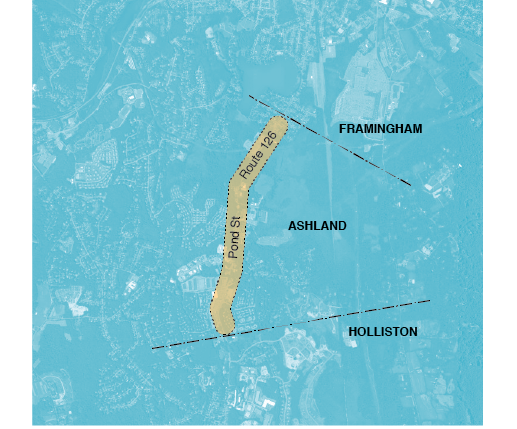
| Reconstruction of Route 126 (Pond Street) (Ashland) | $19,569,554 | CS | $19,569,554 | $19,569,554 | |||||
| Cypher Street Extension (Boston) | $9,323,250 | $9,323,250 | $9,323,250 | ||||||
| Reconstruction of Rutherford Avenue, from City Square to Sullivan Square (Boston) | $140,748,052 | MI | $111,685,278 | $29,062,774 | $140,748,052 | ||||
| Roadway, Ceiling, and Wall Reconstruction, New Jet Fans, and other Control Systems in Sumner Tunnel (Boston) | $126,544,931 | MI | $22,115,687 | $22,115,687 | $104,429,244 | ||||
| Allston Multimodal Project (Boston) | $1,200,000,000 | $1,200,000,000 | $1,200,000,000 | ||||||
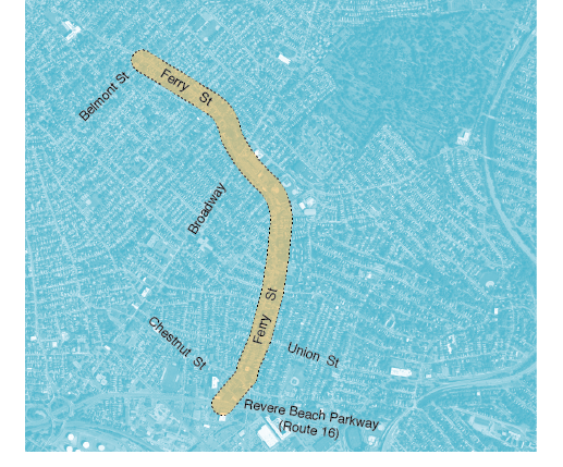
| Reconstruction of Ferry Street (Everett) | $19,836,468 | CS | $19,836,468 | $19,836,468 | |||||
| Reconstruction of Interstate 495 and Interstate 90 Interchange (Hopkinton and Westborough) | $321,000,000 | $321,000,000 | $321,000,000 | ||||||
| Intersection Improvements at Route 126 and Route 135/MBTA and CSX Railroad (Framingham) | $115,000,000 | MI | $165,264,400 | $18,854,300 | $184,118,700 | ||||
| Route 4/225 (Bedford Street) and Hartwell Avenue (Lexington) | $30,557,000 | MI | $48,922,700 | $48,922,700 | |||||
| Reconstruction of Western Avenue (Route 107) (Lynn) | $36,205,000 | MI/CS | $44,048,918 | $44,048,918 | |||||
| Bridge Replacement, Route 27 (North Main Street) over Route 9 (Worcester Street), and Interchange Improvements (Natick) | $45,097,350 | MI | $45,097,350 | $45,097,350 | |||||
| McGrath Boulevard (Somerville) | $66,170,710 | MI | $76,091,250 | $10,984,800 | $87,076,050 | ||||
| Reconstruction on Route 1A (Main Street) (Walpole) | $24,840,039 | CS | $24,840,039 | $24,840,039 | |||||
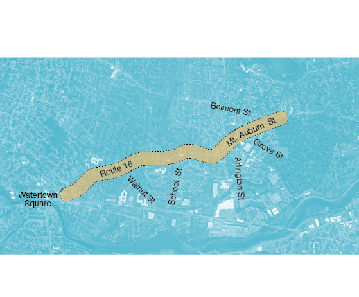
| Rehabilitation of Mount Auburn Street (Route 16) (Watertown) | $28,340,091 | CS | $28,340,091 | $28,340,091 | |||||
| Bridge Replacement, New Boston Street over MBTA (Woburn) | $18,280,891 | MI | $18,280,891 | $18,280,891 | |||||
| Complete Streets Program | CS | $216,604,398 | $264,159,914 | $337,757,852 | $453,978,581 | $1,272,500,745 | |||
| Bicycle and Pedestrian Program | B/P | $22,276,674 | $30,564,014 | $37,528,650 | $50,442,065 | $140,811,403 | |||
| Intersection Improvement Program | INT | $60,560,398 | $79,466,436 | $97,574,491 | $131,149,368 | $368,750,693 | |||
| Community Connections | CC | $6,800,000 | $12,225,606 | $15,011,460 | $20,176,826 | $54,213,892 | |||
| Transit Modernization Program | TM | $30,564,014 | $37,528,650 | $50,442,065 | $118,534,729 | ||||
| Total Available Regional Highway Target Funds | $533,165,850 | $611,280,276 | $750,573,005 | $1,008,841,291 | $2,903,860,422 | $1,643,908,994 | |||
| Total Programmed Regional Highway Target Funds | $524,860,463 | $611,280,276 | $750,573,003 | $725,043,205 | $2,611,756,947 | ||||
| Regional Highway Target Funds Available | $8,305,387 | $0 | $2 | $283,798,086 | $292,103,475 | ||||
| Percentage of Allocated Funding | 98% | 100% | 100% | 72% | 90% | ||||
| Major Infrastructure | $218,618,993 | $194,300,292 | $225,171,900 | $18,854,300 | $656,945,485 | ||||
| Complete Streets | $216,604,398 | $264,159,914 | $337,757,852 | $453,978,581 | $1,272,500,745 | ||||
| Bicycle and Pedestrian | $22,276,674 | $30,564,014 | $37,528,650 | $50,442,065 | $140,811,403 | ||||
| Intersection Improvement Program | $60,560,398 | $79,466,436 | $97,574,491 | $131,149,368 | $368,750,693 | ||||
| Community Connections | $6,800,000 | $12,225,606 | $15,011,460 | $20,176,826 | $54,213,892 | ||||
| Transit Modernization | $0 | $30,564,014 | $37,528,650 | $50,442,065 | $118,534,729 | ||||
| Unallocated Funds | $8,305,387 | $0 | $2 | $283,798,086 | $292,103,475 | ||||
| Total | $533,165,850 | $611,280,276 | $750,573,005 | $1,008,841,291 | $2,903,860,422 | ||||
| Major Infrastructure | 41% | 32% | 30% | 2% | 23% | ||||
| Complete Streets | 41% | 43% | 45% | 45% | 44% | ||||
| Bicycle and Pedestrian | 4% | 5% | 5% | 5% | 5% | ||||
| Intersection Improvement Program | 11% | 13% | 13% | 13% | 13% | ||||
| Community Connections | 1% | 2% | 2% | 2% | 2% | ||||
| Transit Modernization | 0% | 5% | 5% | 5% | 4% | ||||
| Unallocated Funds | 2% | 0% | 0% | 28% | 10% | ||||
| Total | 100% | 100% | 100% | 100% | 100% | ||||
| B/P = Bicycle and Pedestrian Program. CC = Community Connections Program. CS = Complete Streets Program. FFY = Federal Fiscal Year. INT = Intersection Improvement Program. MBTA = Massachusetts Bay Transportation Authority. MI = Major Infrastructure Program. MPO = Metropolitan Planning Organization. TM = Transit Modernization Program. | |||||||||
The following are descriptions for the three new projects are that being amended into the MPO’s Major Infrastructure Program.
This project will reconstruct 1.7 miles of Route 126 to achieve a cross-section consisting of a single 11-foot wide travel lane in each direction, five-foot wide bicycle lanes in both directions, and a five-foot wide sidewalk on both sides of the roadway. Ten-foot wide turn lanes and new crosswalks are proposed at several intersections, and a midblock crosswalk is proposed at the Bay Circuit Trail crossing. Additional improvements include the signalization at the intersection of Route 126 and Eliot Street, restriping, drainage improvements, and resurfacing.
The intersection of Route 126 and Eliot Street experiences significant peak-hour delay. Signalizing the intersection will improve operations along this corridor.
The majority of Route 126 within the project limits currently has no sidewalks, and existing sidewalks have inconsistent connectivity. There are no bicycle accommodations other than the bicycle detection at signalized intersections. The proposed cross-section will provide both sidewalks and bicycle lanes throughout the project area.
The project area currently has no bicycle accommodations and limited pedestrian accommodations. The addition of sidewalks and bicycle lanes will improve safety along the corridor.
Large sections of pavement within the project area are cracked. Pavement markings at several intersections are faded.
The construction of sidewalks and bicycle lanes will encourage mode shift, and operational improvements at the Route 126 and Eliot Street intersection will significantly reduce delay.
This project meets equity criteria for limited English proficiency populations and low-income households.
The project will provide new connections to the Framingham commuter rail station, improve multimodal connectivity to the Pond Street Mixed Use District (a regionally significant development priority area), and serve an area of concentrated development.
This project will reconstruct the 1.4-mile Ferry Street/South Ferry Street corridor from the Malden city line to Revere Beach Parkway (Route 16), as well as a 1,000-foot segment of Elm Street from Ferry Street to Woodlawn Street. Proposed improvements include full-depth pavement reconstruction, the construction of Americans with Disabilities Act-compliant curb ramps, curb extensions at key intersections, and drainage improvements. Traffic signal equipment at five locations will be upgraded and coordinated, and the intersection of Ferry Street, South Ferry Street, and Chelsea Street will be reconstructed as a modern roundabout. The new signal equipment will include vehicle and bicycle video detection.
Several intersections in the corridor experience significant peak hour delay, most significantly at the Ferry Street, South Ferry Street, and Chelsea Street intersection. In addition, the lack of signal coordination contributes to slow travel speeds along the corridor. The proposed signal improvements and reconstruction of the Chelsea Street intersection will reduce delay and improve traffic flow through the corridor.
MBTA Routes 104, 109, 110, and 112 provide bus service in the corridor with connections to the MBTA Blue Line at Wood Island Station and to the MBTA Orange Line at Sullivan Square Station and Wellington Station.
There were 163 crashes reported along the corridor from 2013 to 2015, including 24 bicycle crashes and 24 pedestrian crashes. The new signal equipment with vehicle and bicycle video detection will help improve safety.
Full-depth reconstruction of substandard pavement is proposed within the project limits.
This project meets equity criteria for minority, limited English proficiency, elderly, and disability populations, as well as low-income and zero vehicle households.
The roadway improvements facilitate vehicular access to Everett’s commercial triangle, a regionally significant development priority area bordering Route 16.
The proposed project will reconstruct approximately 9,300 feet of Mount Auburn Street, from the Cambridge city line to its intersection with Summer Street. A road diet will allow for double buffered bicycle lanes in two segments of Mount Auburn Street, from Walnut Street to Dexter Avenue, and from Prentiss Street to the Cambridge city line. A single painted buffer will be provided near Coolidge Square. Curb extensions will be installed at selected locations to shorten crossing distances, and deficient sidewalks and curb ramps will be reconstructed. Transit signal priority is planned for the MBTA Route 71 bus. Additional improvements include upgrading signal equipment, improved signal timing, full-depth pavement reconstruction, and drainage improvements.
Updated signal timings will provide improved traffic flow through the corridor.
The construction of new bicycle lanes, as well as the reconstruction of sidewalks and deficient curb ramps, will improve access for these users.
The implementation of transit signal priority in the corridor will improve the performance of the MBTA Route 71 bus.
One Highway Safety Improvement Program crash cluster is present within the project area, as well as two pedestrian crash clusters.
The project will reconstruct deficient pavement throughout the corridor, upgrade and retime signal equipment, and reconstruct sidewalks and curb ramps.
The project area meets equity criteria for limited English proficiency and elderly populations.
The project builds upon the Town’s 2011 economic development study by improving access to targeted development sites for all roadway users along Mount Auburn Street, which is a MBTA Key Bus Route corridor. In addition to transit signal priority for MBTA Route 71, the improvements will facilitate the flow of people who bicycle by providing buffered lanes and people who walk by shortening crossing distances and bolstering multimodal access to activity centers.
Destination 2040, adopted in August 2019, includes an air quality conformity determination as required by federal regulation. It documents the MPO’s air quality conformity determination for the 1997 ozone National Ambient Air Quality Standards (NAAQS) and carbon monoxide NAAQS and provides information on the applicable conformity requirements according to the latest regulations, regional designation status, legal considerations, and federal guidance. Only projects that change the capacity of the transportation system are required to be part of the air quality conformity determination under federal regulation.
This Amendment is only adding projects to the Major Infrastructure Program in the LRTP because their costs increased to meet the $20 million threshold, which is an MPO requirement and not subject to federal regulation. These projects were included in the FFYs 2020–24 TIP in the Complete Street investment program. This Amendment reclassifies them to the Major Infrastructure program, which includes projects that cost more than $20 million. Therefore, the air quality conformity determination included in Destination 2040 adopted in 2019 is still applicable.
Destination 2040 also includes an air quality analysis required by state legislation in compliance with Massachusetts greenhouse gas (GHG) emission reductions. It includes a section outlining the legislation and regulations requiring carbon dioxide emission reductions in the transportation sector, including the Global Warming Solutions Act and Title 310 of the Code of Massachusetts Regulations, Section 60.05 (310 CMR 60.05), as it applies to the Massachusetts Department of Transportation. As with the federal air quality conformity regulations, the GHG analysis included in Destination 2040, adopted in August 2019, is still applicable. The projects addressed as part of this Amendment were included in the GHG reporting included in the August 2019 Destination 2040 document.
Destination 2040 includes the federally required Title VI and environmental justice analyses to assess how projects in the region, in the aggregate, may affect minority and low-income populations in the Boston region. This Disparate Impact and Disproportionate Burden (DI/DB) analysis determines if these populations may be disproportionately affected by the MPO-funded and Massachusetts Department of Transportation-funded projects in the LRTP that can be modeled. This includes all projects that change the capacity of the transportation network, which are also the same projects that are required in the air quality conformity determination. As with the air quality conformity determination, this Amendment only reclassifies projects to the Major Infrastructure program, which includes projects that cost more than $20 million. They do not change the capacity of the transportation network so they would not be included in the DI/DB analysis. Therefore, the transportation equity analyses included in Destination 2040 adopted in 2019 are still applicable.
1 The Boston Region MPO’s Major Infrastructure Program is defined as projects that change the capacity of the transportation system (required by federal legislation and must be included in an air quality conformity determination) and/or a project that costs more than $20 million (a Boston MPO requirement only).