Technical Memorandum
DATE: May 6, 2021
TO: Ben Cares and Alexander Train, City of Chelsea
FROM: Casey Claude, MPO Staff
RE: Locations with High Bicycle and Pedestrian Crash Rates in the Boston Region Metropolitan Planning Organization (MPO) Area: Everett Avenue and Chestnut Street in Chelsea
This memorandum summarizes the analyses and improvement strategies for the intersection of Everett Avenue and Chestnut Street in Chelsea.
This memorandum contains the following sections:
The memorandum also includes technical appendices that contain data and methods applied in the study.
The purpose of the Locations with High Bicycle and Pedestrian Crash Rates in the Boston Region MPO Area study is to examine safety, mobility, and comfort issues for bicycle and pedestrian travel at intersections in the Boston Region MPO. The intent of the study is twofold: (1) study high crash locations to understand what is contributing to the danger of walking and bicycling at selected intersections, and (2) identify features of the physical environment in need of improvement for the safety and comfort of pedestrian and bicycle travel. This study supports the MPO’s visions and goals, which include increasing transportation safety, maintaining the transportation system, advancing mobility, and reducing vehicle emissions. This work also gives the communities in which the intersections are located the opportunity to look at the needs of the studied intersections, starting at the conceptual level, before the municipality commits funds for design and engineering. Eventually, if the project qualifies for federal funds, this documentation will be useful for the Massachusetts Department of Transportation (MassDOT).
Following a selection process based on bicycle and pedestrian crash information, equity considerations, and implementation potential (see Appendix A for details), the following three locations were chosen for study:
The location in Chelsea was selected because the intersection at Everett Avenue and Chestnut Street is located within Highway Safety Improvement Program (HSIP) crash clusters for both bicyclists and pedestrians.1 The intersection is also located within a traffic analysis zone (TAZ) that exceeds the regional thresholds for minority and low-income populations.2
MPO staff discussed safety and operations issues at the intersection and the scope of work for the study with the city of Chelsea, which expressed interest and willingness to participate in the study. The proximity of the location to the Route 1 ramp for the Tobin Bridge is perceived as contributing to high vehicle travel speeds along Everett Avenue within the vicinity of the study area. The intersection is a heavily-used connection in downtown Chelsea by travelers of all modes.
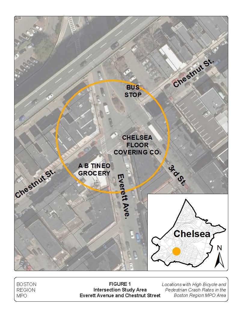
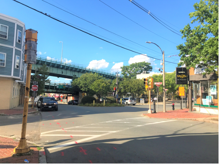
Safe bicycle and pedestrian facilities at the intersection are particularly important due to the location’s proximity to shops and restaurants on Broadway, schools, residential properties, and proposed bicycle facilities to improve the bicycle network in the area. A bus stop at the intersection of Third Street and Chestnut Street, to which the study intersection is connected, generates significant pedestrian travel in the area. The City of Chelsea recognizes the need to improve the intersection of Everett Avenue and Chestnut Street to ensure safe and comfortable travel for all users. Figure 1 shows the location of the intersection and the surrounding roadways.
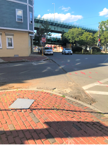
The intersection of Everett Avenue and Chestnut Street is a four-legged intersection that includes flashing red and yellow signals for approaching one-way vehicle traffic. There are two approaches to the intersection. Chestnut Street is a northeast-bound, one-way road with a one-lane approach for through/right-turn movements. The intersection’s second approach is Everett Avenue southbound, which has one left/through lane. The flashing red signal directs motorists on Chestnut Street to stop for traffic on Everett Avenue before proceeding through the intersection, while the flashing yellow signal warns Everett Avenue drivers to be aware of approaching vehicles from Chestnut Street.
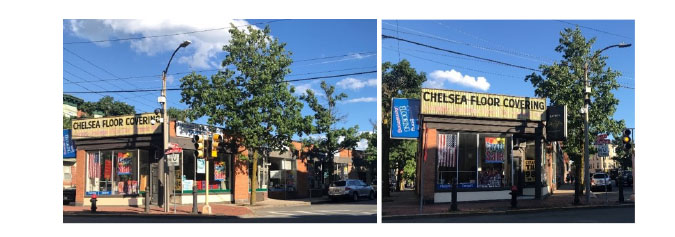
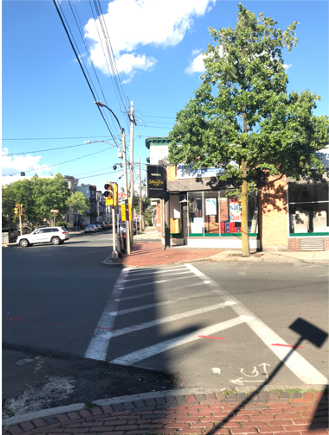
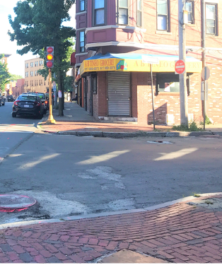
On the southwest corner of the intersection is A B Tineo Grocery (Figure 2). On the northwest corner of the intersection are residential buildings (Figure 3), and the northeast portion of the intersection is not a corner, but instead a pedestrian refuge island (Figure 4). On the other side of the island is Third Street, which joins Everett Avenue just north of the study intersection. The southeast of the intersection is anchored by a mixed-use building that houses the Chelsea Floor Covering Company (Figure 5).
Figure 2
Southwest Corner of Intersection: A B Tineo Grocery
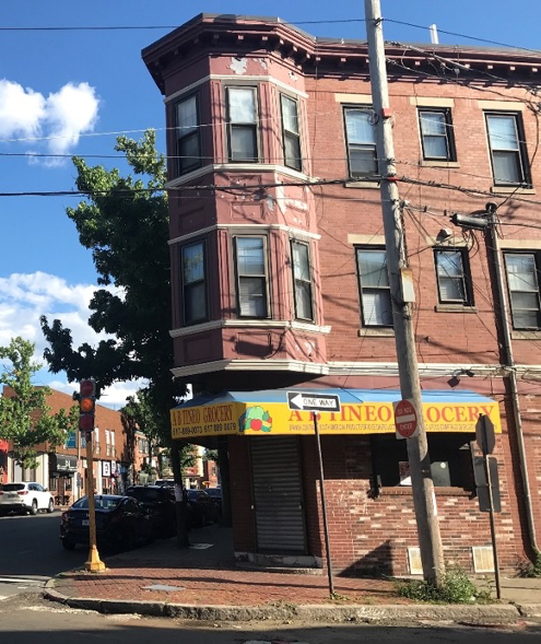
Figure 3
Northwest Corner of Intersection: Residential Buildings
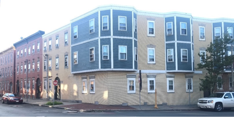
Figure 4
Northeast Corner of Intersection: Pedestrian Refuge Island
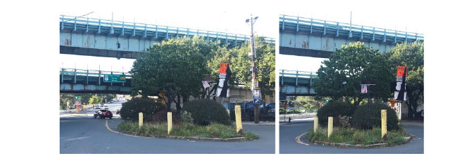
Figure 5
Southeast Corner of Intersection: Chelsea Floor Covering Company
Sidewalks are present throughout the intersection on both sides of the roadways, all exceeding the American with Disabilities Act (ADA) minimum width of five feet. Staff did not observe bicycle facilities along either roadway at this intersection in August 2020, but Chelsea has since added dedicated bike lanes and sharrow markings to Washington Avenue and Broadway from 6th Street to 3rd Street using MassDOT’s Shared Streets & Spaces funding.
There is only one marked crossing where Everett Avenue and Chestnut Street meet: a fading ladder-style crosswalk with solid white lines between two parallel solid white lines marks the southern leg of the intersection, guiding users across Everett Avenue along the south side of Chestnut Street. Neither the crosswalks on Everett Avenue nor Chestnut Street direct pedestrians to cross to the island on the intersection’s northeastern corner.
Figure 6
Marked crosswalk on Everett Avenue across southern leg of the intersection.
When MPO staff visited the area on August 18, 2020, it appeared that the pavement on Chestnut Street had been scarified. While aerial imagery indicates that a crosswalk had previously been painted along the western leg of the intersection, the scarification presumably removed the pavement markings. MPO staff did not observe a crosswalk painted for pedestrians traveling along the west side of Everett Avenue, crossing Chestnut Street.
Figure 7
Scarified pavement without marked crosswalk where Chestnut Street meets Everett Avenue.
Connected to the study area is the intersection of Third Street and Chestnut Street. Along Third Street, just north of the intersection, is a bus stop for the 111, 112, and 114 bus routes.
Both of the intersection approaches feature on-street parking. Along the Chestnut Street approach, cars can park along both sides of the roadway. Along the Everett Street approach, cars can park along the west side of the street. South of the Chestnut Street intersection, Everett Avenue includes on-street vehicle parking on both sides of the roadway.
Figure 8
None of the curb ramps at the intersection include pedestrian detectable warnings with truncated domes.
The biggest concern at the Everett Avenue and Chestnut Street intersection is that it is located within HSIP crash clusters for both pedestrians and bicyclists. As previously explained, there are no bicycle facilities along either roadway. While there are pedestrian accommodations such as sidewalks, there are several elements in need of improvement.
All three curb ramps at the study location lack detectable warnings with truncated domes, which is an ADA requirement to help users with disabilities distinguish between the safety of the sidewalk and the danger of the roadway.
Figure 9
The narrow sidewalks and lack of curb ramps on the intersection island are not ADA-accessible.
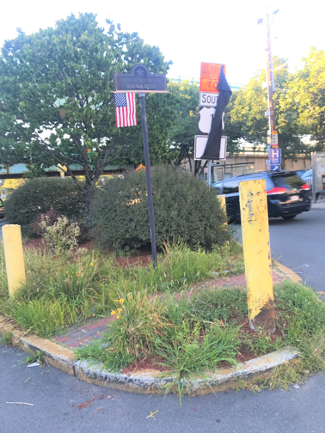
While the curb cuts for the northwest and southeast corners of the intersection guide users into the path of the associated crosswalks, the curb cut on the southwest corner only accommodates one of its marked crosswalks. While the curb ramp on the northwest corner of the intersection suggests there will be an apex curb ramp on the intersection’s southwest corner, in actuality, this curb cut only serves users crossing Everett Avenue at the southern leg of the intersection. There is no curb cut on the intersection’s southwest corner to serve the Chestnut Street crosswalk along the west leg of the intersection. Finally, there appears to be drainage issues with the curb ramp on the intersection’s southeast corner. The pedestrian refuge island at the northeast corner of the intersection includes a small segment of brick sidewalk, but the width does not meet the ADA minimum of five feet. Furthermore, there are no curb cuts on either side of the island, nor are there ADA-accessible curb ramps with detectable warnings featuring truncated domes. This means that the island, which could serve as a useful pedestrian refuge, does not have sidewalks or curb ramps that meet ADA requirements. Finally, vegetation on the island is overgrown, making it difficult for pedestrians to safely gauge breaks in vehicle traffic approaching the intersection along Everett Avenue.
Figure 10
View from curb ramp on intersection’s northwest corner. There is no curb ramp on the southwest corner for the Chestnut Street crossing.
The geometry of the island on the northeast corner makes it easy for drivers to quickly turn left onto Chestnut Street or make a U-turn onto Third Street. However, pedestrians standing on the island waiting for a break in vehicle traffic are barely visible to Everett Street motorists, if at all.
On the northwest corner of the intersection, sight lines for crossing pedestrians, bicyclists, and motorists are impeded by parked cars on the west side of the Everett Avenue approach. These parked cars also make it difficult for oncoming Everett Avenue drivers to see people trying to cross the intersection.
Staff did not observe bicycle racks within the vicinity of the Everett Avenue and Chestnut Street intersection.
Figure 11
Cars parked north of the intersection on Everett Avenue make it difficult to see oncoming traffic from the Chestnut Street approach
On August 18, 2020, MPO staff counted 103 pedestrians and eight bicyclists during one hour of peak PM travel. Staff observed many pedestrians traveling through the intersection heading towards or returning from the bus stop just north of the Third Street and Chestnut Street intersection. Only one bicyclist was observed traveling in the wrong direction along a one-way street.
MPO staff graded the intersection of Everett Avenue and Chestnut Street in Chelsea using the Boston Region MPO’s Pedestrian Report Card Assessment (PRCA)3 and Bicycle Report Card4 tools to assess the safety and comfort of the area for people walking and bicycling. The grading categories reflect the MPO’s Long-Range Transportation Plan (LRTP) goals and assess the quality of four different aspects of the environment: Capacity Management and Mobility, Economic Vitality, Safety, and System Preservation. The report cards also prioritize locations based on Transportation Equity factors, incorporating another Boston region LRTP goal.
Figure 12
Non-Signalized Intersection PRCA for Everett Avenue and Chestnut Street
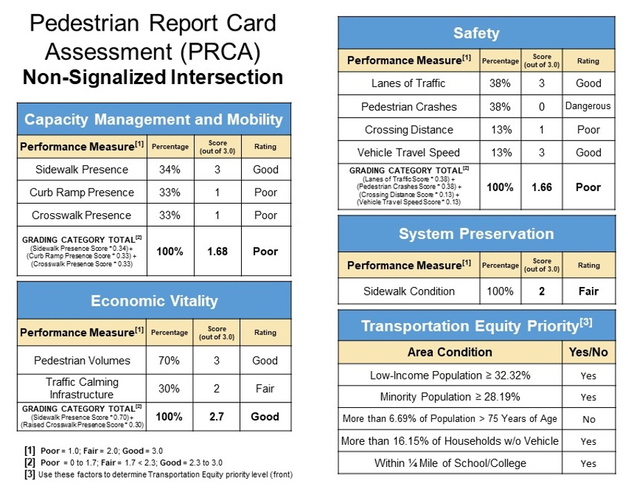
The intersection received a “poor” score for Capacity Management and Mobility, in spite of the presence of sufficiently wide sidewalks along both sides of the two roadways. This was due to the complete absence of detectable warnings, such as truncated domes, and the fact that only one leg of the intersection was marked with a crosswalk.
The intersection received a “good” rating in the subject of Economic Vitality, because many pedestrians travel through the location. Additionally, the southeast corner of the intersection included a sidewalk bump-out, which is a type of traffic calming infrastructure.
Although the intersection scored well in two performance measure categories, the intersection performed “poor” in the Safety category. This was due to the study area being located within an HSIP-eligible crash cluster and because the narrowest marked crossing at the intersection measured more than 35 feet wide. On the positive side of this location’s Safety score was the fact that both Everett Avenue and Chestnut Street include only one lane of vehicle travel, which minimizes potential conflict points with motorists for pedestrians crossing either roadway. Additionally, vehicle-travel speed was considered “good” at the intersection of Everett Avenue and Chestnut Street because the average speed does not exceed 25 miles per hour.
Sidewalk condition was “fair” at this location because many segments of concrete were cracked and in need of repair; however, the sidewalks were sufficiently wide and located on both sides of all four intersection legs. Overall, the intersection was considered a High Priority area for pedestrian transportation equity because the proportions of all four populations at the location (low income, minority, elderly, and zero-vehicle households) exceed the regional averages, and the intersection was located within a quarter mile of a school.
Figure 13
Bicycle Report Card for Everett Avenue and Chestnut Street
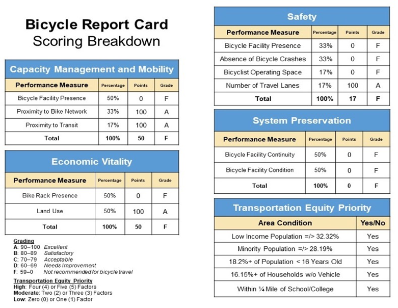
The intersection of Everett Avenue and Chestnut Street received a failing score for every Bicycle Report Card grading category. The lack of bicycle facilities played a large factor in the ratings. In Capacity Management and Mobility, this absence outweighed the fact that the intersection was within a quarter mile of bicycle lanes at the intersection of Walnut Street and Fourth Street, and that the bus stop at the intersection of Third Street and Chestnut Street was feet away from the study location, much closer than the half mile Proximity to Transit metric. In the Economic Vitality category, the absence of bicycle racks effectively negated the value of the diverse land uses at the location, which create many origins and destinations for people who bicycle within the study area.
Although Everett Avenue and Chestnut Street include only one lane of vehicle travel, the intersection received a “poor” Safety score. This can be attributed to the lack of bicycle facilities at the intersection, the associated absence of operating space for bicycles along both roadways, and the fact that Chestnut Street meets Everett Avenue within an HSIP-eligible bicycle crash cluster.
Without bicycle facilities at the location, it was impossible for either roadway to earn points for bicycle System Preservation, which led to another failing grade. Overall, the intersection was considered a High Priority area for pedestrian transportation equity because the proportions of all four populations at the location (low income, minority, youth, and zero-vehicle households) exceed the regional averages and the intersection was located within a quarter mile of a school.
Twenty-eight crashes were recorded over the five-year period between 2013 and 2017. Table 1 breaks these crashes down by type of collision, severity, and factors that may have influenced the crash. While none of the crashes involved bicyclists, six included pedestrians. All six pedestrian crashes involved a single vehicle and primarily occurred under dry, clear conditions during daylight, off-peak travel hours.
Table 1 |
||||
2013–17 Crash Summary Table |
||||
Crash Variable |
Number of Total Crashes |
Number of Vehicle-Only Crashes |
Number of Pedestrian-Involved Crashes |
Number of Bicyclist-Involved Crashes |
Crash Severity |
-- |
-- |
-- |
-- |
Non-Fatal Injury |
10 |
4 |
6 |
0 |
Property Damage Only |
18 |
18 |
0 |
0 |
Total Crashes |
28 |
22 |
6 |
0 |
Type of Collision |
-- |
-- |
-- |
-- |
Angle |
8 |
8 |
0 |
0 |
Rear-End |
5 |
5 |
0 |
0 |
Sideswipe, Opposite Direction |
1 |
1 |
0 |
0 |
Sideswipe, Same Direction |
7 |
7 |
0 |
0 |
Single Vehicle Crash |
7 |
1 |
6 |
0 |
Total Crashes |
28 |
22 |
6 |
0 |
Road Surface Condition |
-- |
-- |
-- |
-- |
Dry |
22 |
17 |
5 |
0 |
Wet |
6 |
5 |
1 |
0 |
Total Crashes |
28 |
22 |
6 |
0 |
Ambient Light Condition |
-- |
-- |
-- |
-- |
Dawn |
2 |
1 |
1 |
0 |
Daylight |
15 |
11 |
4 |
0 |
Dark—Lighted Roadway |
11 |
10 |
1 |
0 |
Total Crashes |
28 |
22 |
6 |
0 |
Weather Condition |
-- |
-- |
-- |
-- |
Clear |
18 |
14 |
4 |
0 |
Cloudy |
5 |
4 |
1 |
0 |
Rain |
4 |
3 |
1 |
0 |
Not Reported |
1 |
1 |
0 |
0 |
Total Crashes |
28 |
22 |
6 |
0 |
Travel Period |
-- |
-- |
-- |
-- |
Peak AM* |
4 |
4 |
0 |
0 |
Peak PM* |
3 |
3 |
0 |
0 |
Off-Peak |
21 |
15 |
6 |
0 |
Total Crashes |
28 |
22 |
6 |
0 |
Five-Year Average |
5.6 |
4.4 |
1.2 |
0.0 |
* Peak periods are defined as 6:00–9:00 AM and 3:00–6:00 PM.
Highlights of these data include:
MPO staff also prepared a collision diagram for the study intersection to examine crash patterns. Police reports were obtained for the years 2013–17. Figure 14 shows the collision diagram. The index numbers in the collision diagram may be used to cross-reference the crash records included in Appendix B. The index numbers with circles around them refer to injury or fatal crashes, depending on the thickness of the circle line.
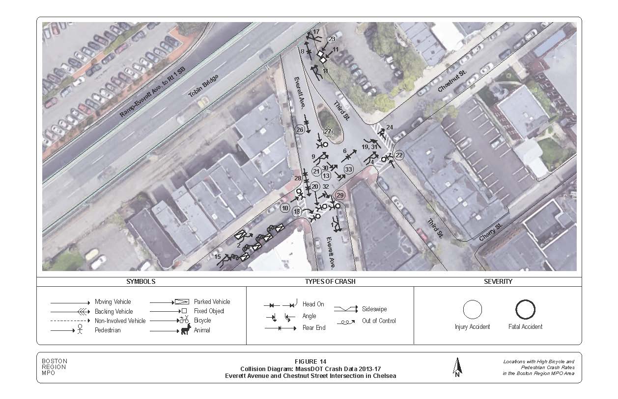
After analyzing the collision data, MPO staff concluded that crashes within the study area primarily appear to be caused by confusion and lack of visibility. Four of the six pedestrian-involved crashes included pedestrians who were entering or crossing a marked crosswalk at the intersection. The other two pedestrians were hit crossing the intersection where there was not a crosswalk. This may be attributed to three overarching factors:
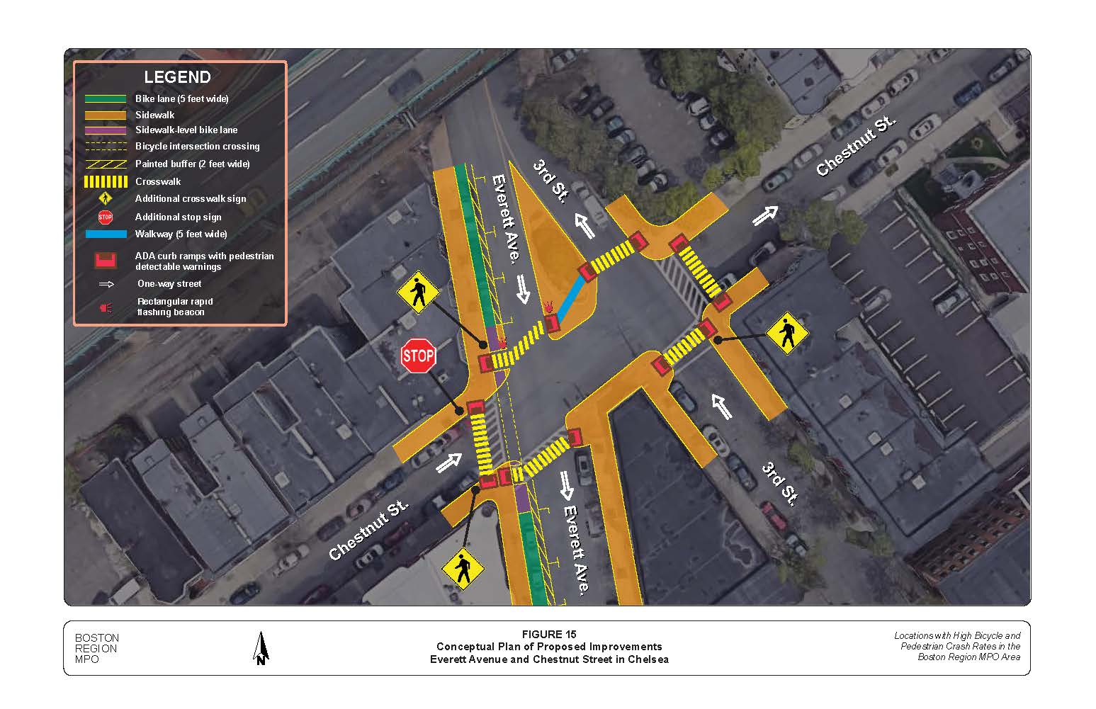
An improvement that would help all users in the intersection is the addition of a stop sign on the north side of Chestnut Street where it meets Everett Avenue. There should be a stop sign on either side of the roadway at the location, because there is only one direction of travel on Chestnut Street. A stop line should be painted ahead of the stop signs on Chestnut Street and on-street parking should not extend closer to Everett Avenue than the line marking. These recommendations and those listed below are illustrated in Figure 15.
Pedestrian Improvements
Bicycle Improvements
Rapid Implementation Suggestion
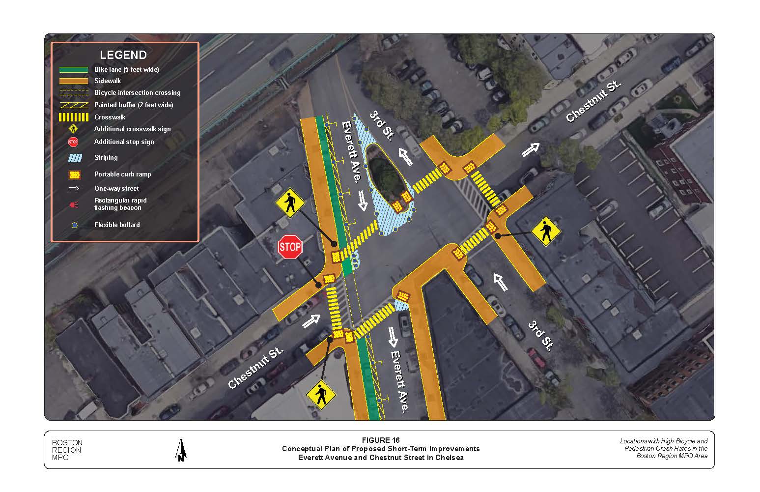
Before new physical features can be constructed, use pavement markings such as striping to extend sidewalks, add bump-outs, and reconfigure the island’s geometry to quickly improve intersection safety (Figure 16). This approach makes it possible to inexpensively test the proposed changes to the built environment. Adding features such as traffic cones, flexible bollards, or large planters will help communicate that drivers should not enter painted pavement locations.
The above evaluations and recommendations support the need for improvements that would enhance bicycle and pedestrian safety and comfort at the intersection of Everett Avenue and Chestnut Street in Chelsea. All of the suggestions address concerns related to crashes involving people walking or bicycling. A key concern is the speed at which motorists travel along Everett Avenue within the vicinity of the intersection, which may warrant additional signalization and intersection reorientation. Although MPO staff were not able to analyze traffic volumes and assess travel patterns due to the COVID-19 pandemic, this memorandum presents several approaches that the City of Chelsea could take to improve the quality of the pedestrian and bicyclist environment at this intersection without severely impacting other modes of travel.
As traffic patterns return to previous levels over the coming months and years, Chelsea should consider documenting the motorists, bicyclists, pedestrians, and other users who regularly travel through the intersection of Everett Avenue and Chestnut Street. A better understanding of travel volumes by mode and turning movements would be helpful for conducting the signal warrant analysis recommended in this memorandum. If future assessments of the intersection determine that the location would benefit from geometric reconfiguration or the installation of infrastructure, such as pedestrian signals, Chelsea may consider applying for Transportation Improvement Program funding through the Boston Region MPO.
The Boston Region Metropolitan Planning Organization (MPO) operates its programs, services, and activities in compliance with federal nondiscrimination laws including Title VI of the Civil Rights Act of 1964 (Title VI), the Civil Rights Restoration Act of 1987, and related statutes and regulations. Title VI prohibits discrimination in federally assisted programs and requires that no person in the United States of America shall, on the grounds of race, color, or national origin (including limited English proficiency), be excluded from participation in, denied the benefits of, or be otherwise subjected to discrimination under any program or activity that receives federal assistance. Related federal nondiscrimination laws administered by the Federal Highway Administration, Federal Transit Administration, or both, prohibit discrimination on the basis of age, sex, and disability. The Boston Region MPO considers these protected populations in its Title VI Programs, consistent with federal interpretation and administration. In addition, the Boston Region MPO provides meaningful access to its programs, services, and activities to individuals with limited English proficiency, in compliance with U.S. Department of Transportation policy and guidance on federal Executive Order 13166. The Boston Region MPO also complies with the Massachusetts Public Accommodation Law, M.G.L. c 272 sections 92a, 98, 98a, which prohibits making any distinction, discrimination, or restriction in admission to, or treatment in a place of public accommodation based on race, color, religious creed, national origin, sex, sexual orientation, disability, or ancestry. Likewise, the Boston Region MPO complies with the Governor's Executive Order 526, section 4, which requires that all programs, activities, and services provided, performed, licensed, chartered, funded, regulated, or contracted for by the state shall be conducted without unlawful discrimination based on race, color, age, gender, ethnicity, sexual orientation, gender identity or expression, religion, creed, ancestry, national origin, disability, veteran's status (including Vietnam-era veterans), or background. A complaint form and additional information can be obtained by contacting the MPO or at http://www.bostonmpo.org/mpo_non_discrimination. To request this information in a different language or in an accessible format, please contact Title VI Specialist |
1 An HSIP eligible cluster is one in which the total number of Equivalent Property Damage Only (EPDO) crashes is within the top five percent in the region. EPDO is a method of combining the number of crashes with the severity of crashes based on a weighted scale. Prior to 2016, the weighting factors used were as follows: a fatal crash was worth 10 points, an injury crash was worth 5 points, and a property-damage only crash was worth 1 point. Starting in 2016, the weighting factors were updated so that fatal and injury crashes are worth 21 and a property-damage only crash is worth 1. An HSIP eligible pedestrian crash cluster has an EPDO within the top five percent of all pedestrian crash clusters in the region.
2 A TAZ is the unit of geography most commonly used in conventional transportation planning models for tabulating transportation-related data. A TAZ usually consists of one or more census blocks, block groups, or census tracts. A map of the Boston region’s TAZs can be found at https://www.ctps.org/node/3122.
3 Boston Region Metropolitan Planning Organization, “Pedestrian Level-of-Service” (Prepared by Ryan Hicks and Casey-Marie Claude, January 2017). https://www.ctps.org/ped-report-card. [Updated in 2019: Boston Region Metropolitan Planning Organization, “Pedestrian Report Card Assessment Interactive Database” (Prepared by Casey-Marie Claude, November 2019). https://www.ctps.org/data/pdf/programs/bike_ped/prca_app/2019-11-21_PRCA_Interactive_Database.pdf.]
4 Boston Region Metropolitan Planning Organization, “Development of a Scoring System for Bicycle Travel in the Boston Region” (Prepared by Casey-Marie Claude, November 2018). https://www.ctps.org/bicycle-level-of-service.
5 United States Access Board, “Accessible Public Rights-of-Way: Planning and Designing for Alterations; Chapter 6—Curb Ramp Examples” (Prepared by Otak, Inc. August 2007). https://www.access-board.gov/prowag/planning-and-design-for-alterations/chapter6/.
6 Association of Pedestrian and Bicycle Professionals (APBP), “Essentials of Bike Parking: Selecting and Installing Bike Parking that Works” (Prepared by Alta, September 2015). https://www.apbp.org/assets/docs/EssentialsofBikeParking_FINA.pdf.