Technical Memorandum
DATE: May 6, 2021
TO: Maurice Goulet, Director of Public Works, Town of Medfield
FROM: Chen-Yuan Wang and Chaopeng Hu, MPO Staff
RE: Safety and Operations Analyses at Selected Intersections,
FFY 2020—North Meadows Road (Route 27) at West Street in Medfield
This memorandum summarizes the analyses and improvement strategies for the intersection of North Meadows Road (Route 27) at West Street in Medfield. This intersection was selected through a comprehensive review of 30 potential study locations in the region.1
The memorandum covers the following sections:
In addition, the memorandum includes technical appendices that contain supporting data and methods applied in the study.
The purpose of the “Safety and Operations Analyses at Selected Intersections” study is to examine safety, operations, and mobility issues at major intersections in the Boston Region Metropolitan Planning Organization (MPO) area’s arterial highways where many crashes occur, congestion during peak traffic periods may be heavy, or improvements for bus, bicycle, and pedestrian travel are needed.
For more than 10 years, the MPO has been conducting these planning studies with municipalities in the region. The communities find the studies beneficial, as they give them an opportunity to begin looking at the needs of problematic locations at the conceptual level, before they commit funds for design and engineering. Eventually, if the project qualifies for federal funds, the study’s documentation will also be useful to the Massachusetts Department of
Transportation (MassDOT) and its project-development process.
These studies support the MPO’s visions and goals, which include increasing transportation safety, maintaining the transportation system, advancing mobility, and reducing congestion.
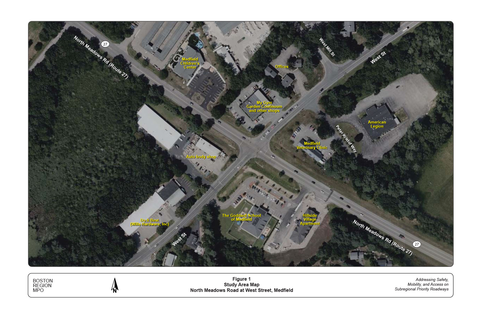
North Meadows Road (Route 27) at West Street is a four-way signalized intersection. It is one of a few signalized intersections in Medfield, located within one mile northwest of the town center. Figure 1 shows the location of the intersection, existing street layouts, and major developments in the study area.
Route 27 is a north-south state highway running from Kingston to Chelmsford. For most of its route, it serves as an intermediate arterial between Interstate 95 and Interstate 495 and is heavily used by commuters in the region. The section of Route 27 north of Route 129 in Medfield is known as North Meadows Road. It consists of two travel lanes, one in each direction (approximately 12 to 14 feet wide) with a double yellow centerline, and a relatively wide (10 feet or greater) shoulder on both sides. There are no sidewalks on either side of the roadway. The speed limit is 45 miles per hour (mph) in both directions approaching the study intersection.2 The roadway, classified as an urban principal arterial, is under the town’s jurisdiction and is a part of the National Highway System (NHS).
West Street is an urban minor arterial owned by the town. The roadway is about one and one-quarter miles long. It connects to Harding Street and Dover Road, which continue east to Dover and west to Millis. It is a two-lane roadway that contains a travel lane approximately 11 to 12 feet wide and a shoulder of two to three feet in each direction. It has no sidewalks, except the north side of the street about 600 to 1,400 feet west of the intersection from Marsh Drive to Gatehouse Drive. The speed limit is 35 mph in both directions in the vicinity of the intersection.
Figure 1
Study Area Map
North Meadows Road at West Street, Medfield
At the intersection, all the approaches increase in width but remain a single travel lane shared by all turning movements. North Meadows Road flares to more than 30 feet wide in both approaches, which allows one or two right-turning vehicles to wait at the stop line or to turn right on red. However, there are no lane use pavement markings on these approaches. The flared areas on both approaches are also frequently used by through traffic to go around a left-turning traffic queue. West Street flares just slightly with no space for the storage of additional right-turning vehicle at the stop line. With the stop lines positioned far back (20 to 30 feet) from the intersection and wide turning radii at all corners, the intersection appears to be very large even though it has only one lane on all approaches.
The traffic signal at the intersection operates in a simple two-phase mode: one phase for both approaches of North Meadows Road and one phase for both approaches of West Street, with no pedestrian signal phases. Based on field observations, it operates at a cycle length of 74 seconds that consist of 38 seconds (30-second green time, plus 4-second yellow change interval and 4-second all-red interval) for North Meadows Road approaches and 36 seconds (30-second green time, plus 4-second yellow change and 2-second all-red interval) for West Street approaches.
Standard three-section signals are provided on all approaches of the intersection. Two overhead signals are provided for each of the North Meadows Road approaches. One overhead signal and one post-mounted signal are provided for both approaches of West Street. The post-mounted signals are not well positioned for drivers, as they are low and located far from the intersection center. All the signals at the intersection are not equipped with backplates or retroreflective borders.
There are no crosswalks at the intersection and no sidewalks on either side of all the approaches. There are guardrails present at all corners, except the northeast corner. Under the existing intersection layout, these guardrails are used to prevent the turning vehicles from driving into adjacent ditches or parking lots and to protect the roadside signal and lighting equipment. They also deter people who are walking from crossing the intersection where the traffic conditions can be complicated and compel them to cross at other locations with narrower road width or marked crosswalks with protected pedestrian signals, such as the intersection of North Meadows Road at Dale Street.
There are no dedicated bicycle accommodations on either roadway in the study area. North Meadows Road contains shoulders of approximately 10 feet wide on both sides. Some shoulder sections between Route 109 and Dale Street are marked with white hatch lines to prohibit parking. The hatched shoulders could discourage people who ride bicycles from using the shoulders and compel them to use the travel lanes. Meanwhile, in other unmarked shoulder sections, parked vehicles could occupy the space from time to time, as there are no clear regulations about parking on North Meadows Road. West Street contains narrow shoulders of approximately two to three feet wide, which are not suitable for bicycle travel.
There are no public transit stops and no marked on-street parking spaces in the areas adjacent to the intersection.
The land uses in the vicinity of the intersection include business, industrial, residential, and school. Adjacent to the intersection, there are a number of businesses, including a fun and fitness center for children (My Gym), a landscape design company, a daycare (Medfield Children’s Center), an auto body shop, an early education school (The Goddard School of Medfield), and a veterinarian clinic. Further out, the land uses on North Meadows Road include multi-family residents and undeveloped land to the south, and mostly open space to the north. The land uses on West Street include a number of businesses and industrial offices and a nonprofit organization (American Region) to the east, and mostly residential and a hardware store (Do it Best) to the west.
The intersection is located in one of the fastest growing areas in Medfield. The Town currently is in the process of developing a new master plan. The areas adjacent to North Meadows Road have the potential for vibrant mixed-use developments, with the support of essential Complete Streets elements. A key element would be to reconstruct the intersection and improve operations and safety for users of all modes.
Based on MPO staff’s field observations, discussions with the town officers, and analyses of crash data and existing operations, major issues and concerns at the intersection include the following.
Crash data analysis is essential to identify safety and operational problems at an intersection. Analyzing the data on the frequency of crashes, types and patterns of collisions, and the circumstances under which crashes occur, such as the time of day and roadway surface conditions, helps to develop improvement strategies.
This intersection is ranked 121 of the 2014–16 state top 200 crash locations with a high Equivalent Property Damage Only (EPDO) crash rate.3 MassDOT conducted a Road Safety Audit (RSA) for this intersection on June 15, 2019.4 The RSA analysis was based on crash data from 2014 to 2017. To further examine the intersection safety conditions with updated data, MPO staff added the recent two-year crash data (Medfield Police crash reports from January 2018 to November 2019) for this study.
In total, 46 crashes occurred during the six-year period. Table 1 summarizes the severity, collision type, pedestrian or bicycle involvement, time of day, weather, and pavement conditions of the 46 crashes by year and in total.
Nearly 40 percent (17) of total crashes at the intersection caused personal injuries. The most prevalent crash type is the angle collision, 60 percent (28) of all crashes. The second most common type is the rear-end collision, accounting for nearly 25 percent (11) of all crashes. There were a few other types of collisions, such as single-vehicle and sideswipe collisions, which account for approximately 15 percent (7) of all crashes. No crashes at the intersection involved pedestrians or bicyclists. Noticeably, 56 percent (26) occurred during the weekday peak traffic periods (7:00–9:00 AM and 3:30–6:30 PM).
Table 1
Crash Data Summary
Medfield Police Crash Reports, January 2014–November 2019
| Statistics Period | 2014 | 2015 | 2016 | 2017 | 2018 | 2019 | 6-Year Total | Annual Avg |
| Total number of crashes | 7 | 5 | 10 | 6 | 11 | 7 | 46 | 7.7 |
| Severity, Property damage only | 3 | 2 | 3 | 4 | 9 | 7 | 28 | 4.7 |
| Severity, Nonfatal injury | 4 | 3 | 6 | 2 | 2 | 0 | 17 | 2.8 |
| Severity, Fatality | 0 | 0 | 0 | 0 | 0 | 0 | 0 | 0.0 |
| Severity, Not reported/unknown | 0 | 0 | 1 | 0 | 0 | 0 | 1 | 0.2 |
| Collision type, Single Vehicle | 0 | 1 | 2 | 0 | 1 | 0 | 4 | 0.7 |
| Collision type, Rear-end | 1 | 2 | 1 | 2 | 1 | 4 | 11 | 1.8 |
| Collision type, Angle | 6 | 2 | 6 | 4 | 7 | 3 | 28 | 4.7 |
| Collision type, Sideswipe, same direction | 0 | 0 | 1 | 0 | 1 | 0 | 2 | 0.3 |
| Collision type, Sideswipe, opposite direction | 0 | 0 | 0 | 0 | 0 | 0 | 0 | 0.0 |
| Collision type, Head on | 0 | 0 | 0 | 0 | 1 | 0 | 1 | 0.2 |
| Collision type, Rear-to-rear | 0 | 0 | 0 | 0 | 0 | 0 | 0 | 0.0 |
| Collision type, Not reported/unknown | 0 | 0 | 0 | 0 | 0 | 0 | 0 | 0.0 |
| Involved pedestrian(s) | 0 | 0 | 0 | 0 | 0 | 0 | 0 | 0.0 |
| Involved cyclist(s) | 0 | 0 | 0 | 0 | 0 | 0 | 0 | 0.0 |
| Occurred during weekday peak periods* | 4 | 2 | 6 | 6 | 5 | 3 | 26 | 4.3 |
| Wet or icy pavement conditions | 0 | 1 | 2 | 0 | 1 | 1 | 5 | 0.8 |
| Dark conditions (lit or unlit) | 0 | 1 | 1 | 3 | 1 | 1 | 7 | 1.2 |
| * Peak periods are defined as 7:00–10:00 AM and 3:30–6:30 PM. | ||||||||
| Avg = Average | ||||||||
Based on police reports, staff constructed a collision diagram (Figure 2) that shows the locations and collision patterns of all the crashes at the intersection in the period of nearly six years (each indexed by chronological order of occurrence, including the 2014–17 crashes identified in the RSA). The information of each crash, including date, time, severity, collision type, weather and road conditions, driver contributing code, and police comments are listed in Appendix A.
The major severe crash type at signalized intersections is a right-angle crash, where one vehicle violates the red signal.5 The high number of angle crashes at this intersection resulted in a high injury rate.
As shown in the collision diagram (Figure 2), there were 21 right-angle crashes that can be separated into the following patterns:
Figure 2
Collision Diagram: North Meadows Road at West Street
Medfield Police Reports: January 2014–November 2019
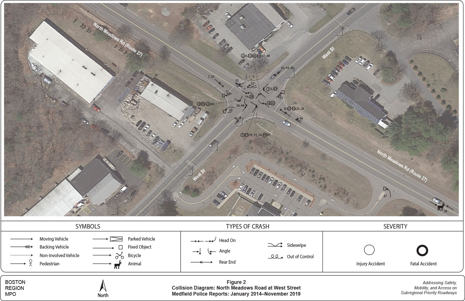
These right-angle crashes plus another angle crash involving a westbound left-turn vehicle and an eastbound through vehicle on West Street, 22 crashes in total (accounting for nearly one-half of all the intersection crashes), were identified to be caused by a vehicle running a red light at the intersection. Further analysis indicates that the number of red-light running on the West Street approaches (14 in total, nine eastbound and five westbound) is higher than that on the North Meadows Road approaches (eight in total, six southbound and two northbound), even though the prevailing travel speeds are much higher on the North Meadows Road approaches.
There is no simple or single reason to explain why motorists run red lights at an intersection. It usually involves a number of factors and the compound effects. For this intersection, the high frequency of red-light running may occur because of one of the following reasons:
The traffic signal at this intersection operates in permissive phasing that allows traffic in the opposite approaches to move concurrently. With no storage lane and no exclusive signal phase, left turns usually have to wait at the intersection for gaps in the opposite traffic stream. Meanwhile, approaching the intersection with no separated lanes, all the movements tend to cluster in the intersection and block each other’s views and cause driver confusion, especially during busy traffic conditions.
There was only one right-turn angle crash that involved a vehicle turning right on westbound and a vehicle going straight on northbound. The crash did not cause injuries.
There were 11 rear-end crashes, which can be separated into the following approaches:
Rear-end crashes at an intersection usually caused by motorists’ inattention, distraction, or not keeping sufficient distance (following too closely) to the vehicle in front. At this intersection, they were mainly caused by the sudden stop of a vehicle in front traveling fast or suddenly slowing down by a left turning vehicle. The RSA indicated that vehicles traveling in the northbound approach on North Meadows Road through the intersection are especially prone to speeding. As a result, there are more rear-end crashes occurring on this approach than the other approaches. Two of the rear-end crashes caused injuries and both occurred on the northbound approach.
The last observed collision pattern contains three single vehicle crashes at the intersection, two at the southwest corner, and one at the northeast corner. They mainly were caused by speeding motorists, turning too fast, or driving carelessly.
To examine the existing traffic conditions, MPO staff requested MassDOT’s assistance in collecting intersection turning movement counts (TMC) and roadway approach speeds using Automatic Traffic Recorder (ATR) counts at various locations for this study. The data collection was delayed by a snowstorm in late November 2019 and periodic snowfall in the following months. In March, just as MassDOT scheduled to collect the counts for this study, the state’s traffic data collection operations were suspended because of the COVID-19 pandemic.
Fortunately, traffic studies for recently proposed developments in the vicinity of the intersection were available for this study to evaluate the existing traffic conditions. These studies are
Based on the ATR counts collected for the Medfield Meadows development traffic study in September 2016 and historical counts collected at the MassDOT continuous count station on Route 27 south of Hospital Road in Medfield (location ID: 39), staff estimated daily traffic volumes on the four roadway sections adjoining the intersection. The estimated volumes represent daily traffic near the intersection under normal conditions (not affected by the pandemic conditions).
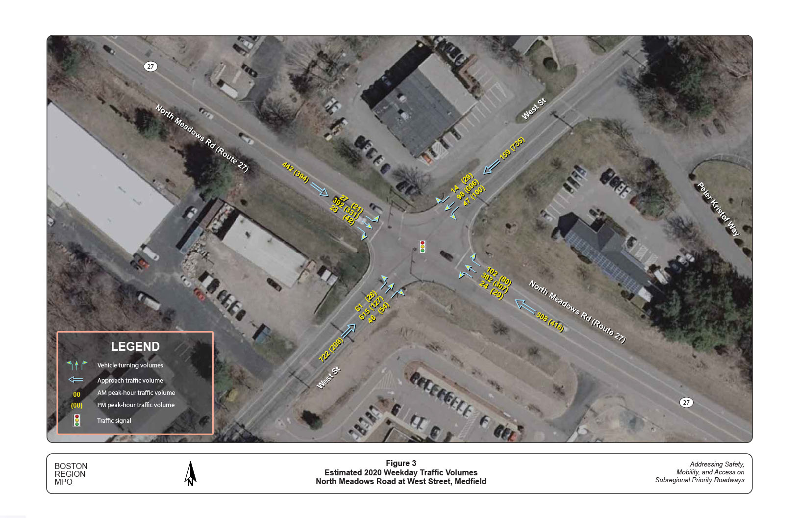
Staff estimated the turning movements at this intersection based on counts from the four traffic studies but pivoting on the two recent studies, the proposed American Legion apartments and the Medfield Meadows residential developments. 7 Figure 3 summarizes the estimated 2020 AM and PM peak-hour traffic volumes by approaches. The estimation represents the optimal conditions in 2020, not the COVID-19 conditions.
The intersection is estimated to carry approximately 1,750 to 1,850 entry vehicles per peak hour during high travel months (September and October) under the normal traffic conditions. In the AM peak hour, the West Street eastbound approach carries a volume much higher than other approaches. In the PM peak hour, the West Street westbound approach carries the highest volume at the intersection. Right-turn volumes are generally low, except the North Meadows Road northbound in the morning, which carries about 100 vehicles per peak hour.
Traffic studies usually apply the observed or estimated 85th percentile speeds to assess how fast vehicles are approaching an intersection. The 85th percentile speed is the speed at or below which 85 percent of vehicles passing a given point are traveling, and is the principal value used to establish speed controls by the state. It can be regarded as the prevailing vehicle speed on the roadway adjacent to the specific location.
Figure 3
Estimated 2020 Weekday Traffic Volumes
North Meadows Road at West Street, Medfield
The above traffic studies provided a few observed 85th percentile speeds at the following locations:
These observed 85th percentile speeds may not be suitable to directly use as approach speeds for the intersection, as the first two locations are located too close to the intersection (about 250 to 300 feet) and the third location is too far and under a lower speed limit. Staff therefore applied 7 mph above the posted speeds as the prevailing approach speeds for the intersection’s operational analyses based on the Institute of Transportation Engineers (ITE) guideline. 8
Based on the estimated turning movement volumes, staff conducted the intersection capacity analysis by using the Synchro traffic analysis and simulation program.9 Staff also reviewed the signal settings of the yellow change and all-red clearance intervals and the issue of pedestrian and bicycle accommodations.
In general, the intersection operates at an acceptable level of service (LOS) on all approaches in both the AM and PM peak hours. Field observations indicated that there were no extensive traffic queues during the peak hours, except the eastbound approach in the morning and the westbound approach in the evening.
Table 2 summarizes the estimated LOS, average delay, and volume to capacity ratio (V/C) for all the approaches at the intersection in the AM and PM peak hours. The estimation is based on an observed cycle length of 74 seconds that consist of 38 seconds (30-second green, plus 4-second yellow, and 4-second all-red) for North Meadows Road approaches and 36 seconds (30-second green, plus 4-second yellow and 2-second all-red) for West Street approaches.
Table 2
Summary of Intersection Capacity Analyses
Estimated 2020 AM and PM Peak-Hour Traffic Conditions
Analysis Period |
AM |
AM |
AM |
PM |
PM |
PM |
Approach |
LOS |
Delay |
V/C |
LOS |
Delay |
V/C |
North Meadows Road NB |
C |
29.6 |
0.82 |
C |
28.6 |
0.78 |
North Meadows Road SB |
C |
28.8 |
0.79 |
C |
26.3 |
0.73 |
West Street EB |
D |
35.0 |
0.90 |
B |
12.0 |
0.29 |
West Street WB |
B |
15.2 |
0.34 |
D |
35.9 |
0.91 |
Intersection Average |
C |
30.0 |
- |
C |
29.0 |
- |
Notes:
Approach: NB = Northbound; SB = Southbound; EB = Eastbound; WB = Westbound
All movements share a single lane on all approaches
AM Peak Hour = 8:00–9:00; PM Peak Hour = 5:00–6:00
Delay = Average delay per vehicle (seconds)
LOS = Level of Service. V/C = Volume to capacity ratio.
Appendix B contains the Synchro reports of the AM and PM intersection capacity analyses underestimated existing conditions. Note that these analyses do not include safety concerns and impacts from the shared single-lane operations (analyzed in the section of crash data analysis).
To further examine the issue of red-light running at this intersection, staff conducted a quick analysis of the yellow change and all-red (red) clearance intervals at this intersection. The yellow change and red clearance intervals compose the two parts of the traffic signal change period. The determination of the intervals depend on a number of factors, including the intersection and approaching roadway characteristics, and traffic conditions.
Appendix C summarizes the estimation of yellow change and red clearance intervals for all the approaches at the intersection, based on the guidelines recommended by ITE. It also includes the existing yellow change and red clearance intervals observed in the field for comparison. Appendix D contains details of the ITE method and formula for calculating the two intervals.
The calculation for the yellow change interval provides the minimum interval to allow time for a motorist to see the yellow signal indication and decide whether to stop or to enter the intersection. This time includes the motorist’s perception-reaction time, generally one second. It should be sufficient time for motorists that are too close to the intersection to decelerate comfortably to a stop and thus reach the intersection before the right-of-way terminates. The calculation for the red clearance interval allows motorists that enter the intersection before the yellow change interval terminates time to continue through to the far side of the intersection before conflicting traffic enters.
Currently, North Meadows Road approaches operate with a signal change period of eight seconds that consists of four seconds of yellow change interval and four seconds of red clearance interval, and West Street approaches operate with a signal change period of six seconds that consists of four seconds of yellow change interval and two seconds of red clearance interval. The yellow change interval for North Meadows Road approaches is slightly short, compared to the estimated five seconds. The red clearance interval for West Street approaches is slightly short, compared to the estimated 2.5 seconds. In terms of the total signal change periods for both roadway approaches, they are close to the estimated 7.5 seconds for North Meadows Road approaches and 6.5 seconds for West Street approaches.
The signal change setting is critical for traffic safety at an intersection. Note that this is a quick estimation based on some assumptions and approximations, including the estimated 85th percentile speeds. In the short term, a further engineering study should be conducted with radar-measured 85th percentile speeds on all approaches and surveyed intersection geometry, before making adjustments to the existing yellow change and red clearance intervals.
In the long term, the intersection should be redesigned with lower approach speeds, reduced turning radii, and signal vehicle detection to minimize dilemma zones. 10 Under the new intersection design, the intersection would operate at the usual range of yellow change interval (three to four seconds) and red clearance interval (one to two seconds).
There are insufficient pedestrian and bicycle accommodations at the intersection and its adjacent areas. Both North Meadows Road and West Street have no sidewalks, except an 800-foot section on the north side of West Street west of the intersection. The intersection has no crosswalks on all approaches.
Both roadways have no dedicated bicycle accommodations. Although North Meadows Road has shoulders of approximately 10 feet wide in both directions approaching the intersection, it has no consistent treatment in accommodating bicycles as parking on the shoulders is not explicitly prohibited and some sections are hatch-marked.
During the recent development of the Medfield town-wide master plan, residents strongly supported more sidewalks and bikes to reduce the dependence on cars and buses and prioritizing walking and biking in the transportation system to enhance the health and wellness of residents. Meanwhile, the intersection was described as a location with major safety and congestion concerns and new developments in the area have generated and will generate more walking trips. Pedestrian and bicycle accommodations should be prioritized in the redesign and reconstruction of the intersection.
Based on the above analyses, MPO staff developed a series of short- and long-term improvements to address safety and operational problems at the intersection. The proposed short-term improvements generally can be implemented within two years at a relatively low cost (usually under $30,000). The proposed long-term improvements are more complicated and cover larger areas, thus requiring intensive planning and design, and significant funding. They are analyzed in the next section. The proposed short-term improvements are summarized below, from the lowest to the highest cost:
The proposed long-term improvements would require intensive planning and design and significant funding. Staff developed a number of long-term improvement alternatives for this intersection and its immediate areas. Based on the goals of maximizing safety and operational benefits for all transportation modes and minimizing land-taking and construction impacts, staff identified three alternatives that are more feasible than others.
Staff also analyzed traffic operations for the alternatives and the base case (no-build scenario) under the projected 2030 traffic conditions. For comparison purposes, the analysis includes a future year no-build scenario that contains only signal retiming with no geometry modifications and no signal system upgrade.
Key elements of the no-build scenario and the three alternatives are summarized as below.
The no-build alternative assumes that the intersection would remain the same as the existing conditions, which include a single lane for all approaches, no crosswalks, no bicycle detection, and no signal system update. The only improvement included is to retime the signal with the estimated yellow change and red clearance intervals (Section 6.2) and a slight reduction of overall cycle length.
Alternative 1 proposes to modify the intersection layout and upgrade the signal system for adding protected left-turn operation, protected pedestrian crossing, and bicycle detection. Figure 4 shows the conceptual plan of the alternative. Key elements of the alternative include
Alternative 2 proposes to modify the intersection layout and upgrade the signal system for adding protected/permissive left-turn operation, protected pedestrian crossing, and bicycle detection. The alternative would require a similar layout to Alternative 1 (see Figure 4 for the conceptual plan).19 Key elements of the alternative include
Alternative 3 proposes to convert the intersection into a single-lane modern roundabout. Figure 5 shows the conceptual plan of the alternative. Key elements of the alternative include
Table 3 summarizes the intersection capacity analyses for the no-build scenario and the three alternatives under the predicted 2030 AM and PM peak-hour traffic conditions.21 Appendix E contains Synchro intersection capacity analysis reports that detail input volumes, lane configurations, signal timing settings, and analysis results of the various alternatives.
In terms of the overall intersection operation, all three alternatives would operate at acceptable levels of services in both the AM and PM peak hours.22 In terms of individual approaches, all three alternatives would operate at acceptable levels of services in the AM peak hour, except the left turns on the West Street westbound in Alternative 1 and the entire approach of West Street eastbound in Alternative 3. In the PM peak hour, all approaches in the three alternatives would operate acceptably.
Note that these capacity analyses do not explicitly indicate the safety benefits of the three alternatives. Alternatives 1and 2 would reduce left-turn crashes and right-angle crashes and thus reduce the crash severity and improve safety for users of all modes at the intersection. Alternative 1 would provide more protection for left turns than Alternative 2 but would also increase average delay per vehicle on all approaches. Alternative 3 would slow down all the traffic through the roundabout and would reduce the crash severity most significantly.
Figure 4
Proposed Long-Term Improvement Alternatives 1 and 2
North Meadows Road at West Street, Medfield
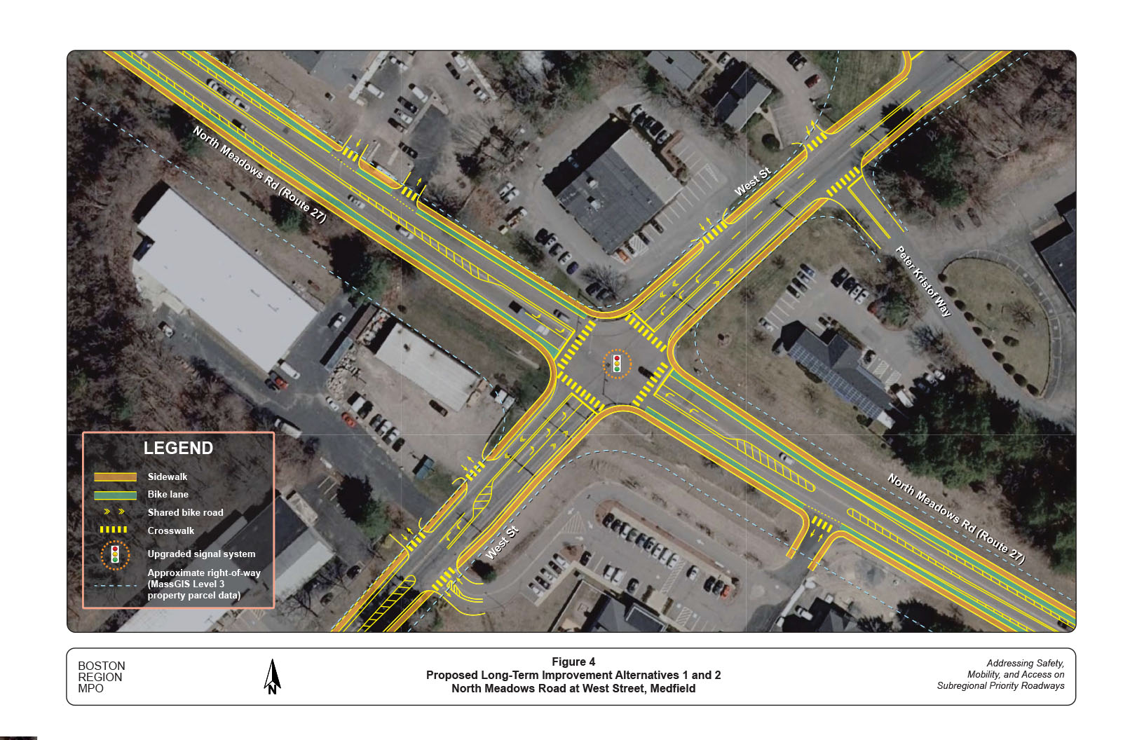
Figure 5
Proposed Long-Term Improvement Alternative 3
North Meadows Road at West Street, Medfield
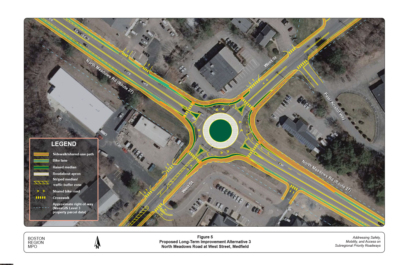
Table 3
Intersection Capacity Analysis
No-Build and Long-Term Improvement Alternatives
2030 Projected Traffic Conditions
| AM Peak Hour Analysis | |||||||||||||||||
| Alternative | No-Build Signal Retiming No Geometry/Signal Improvements |
Alternative 1 Intersection Reconstruction with Protected Left Turns |
Alternative 2 Intersection Reconstruction with Protected/Permissive Left Turns |
Alternative 3 Modern Roundabout Conversion Single-Lane Circulation |
|||||||||||||
| Approach | Lane Group | LOS | Delay | V/C | Lane Group | LOS | Delay | V/C | Lane Group | LOS | Delay | V/C | Lane Group | LOS | Delay | V/C | |
| North Meadows Road NB | L/T/R | C | 32.4 | 0.85 | L | E | 59.2 | 0.37 | L | B | 19.2 | 0.16 | L/T | C | 20.8 | 0.71 | |
| T/R | E | 66.9 | 0.98 | T/R | D | 54.6 | 0.93 | R | A | 7.6 | 0.18 | ||||||
| North Meadows Road SB | L/T/R | C | 31.0 | 0.82 | L | E | 68.4 | 0.48 | L | C | 21.1 | 0.23 | L/T/R | A | 9.8 | 0.53 | |
| T/R | D | 51.6 | 0.90 | T/R | D | 44.6 | 0.85 | ||||||||||
| West Street EB | L/T/R | D | 46.0 | 0.96 | L | D | 48.0 | 0.41 | L | B | 14.3 | 0.12 | L/T/R | F | 85.3 | 1.10 | |
| T/R | E | 57.8 | 0.98 | T/R | D | 58.9 | 0.98 | ||||||||||
| West Street WB | L/T/R | B | 16.2 | 0.39 | L | F | 121.4 | 0.86 | L | C | 21.7 | 0.41 | L/T/R | A | 7.9 | 0.28 | |
| T/R | C | 23.4 | 0.22 | T/R | B | 19.9 | 0.21 | ||||||||||
| Intersection Average | - | D | 35.5 | - | - | E | 58.0 | - | - | D | 48.0 | - | - | E | 39.9 | - | |
| PM Peak Hour Analysis | |||||||||||||||||
| Alternative | No-Build Signal Retiming No Geometry/Signal Improvements |
Alternative 1 Intersection Reconstruction with Protected Left Turns |
Alternative 2 Intersection Reconstruction with Protected/Permissive Left Turns |
Alternative 3 Modern Roundabout Conversion Single-Lane Circulation |
|||||||||||||
| Approach | Lane Group | LOS | Delay | V/C | Lane Group | LOS | Delay | V/C | Lane Group | LOS | Delay | V/C | Lane Group | LOS | Delay | V/C | |
| North Meadows Road NB | L/T/R | C | 31.3 | 0.83 | L | E | 57.5 | 0.37 | L | C | 26.5 | 0.23 | L/T | A | 6.8 | 0.37 | |
| T/R | D | 37.1 | 0.73 | T/R | D | 39.8 | 0.76 | R | A | 3.8 | 0.09 | ||||||
| North Meadows Road SB | L/T/R | C | 27.9 | 0.77 | L | D | 54.2 | 0.28 | L | C | 25.7 | 0.18 | L/T/R | E | 38.5 | 0.87 | |
| T/R | D | 40.5 | 0.76 | T/R | D | 43.1 | 0.79 | ||||||||||
| West Street EB | L/T/R | B | 12.5 | 0.32 | L | E | 63.1 | 0.41 | L | B | 17.9 | 0.20 | L/T/R | A | 8.7 | 0.33 | |
| T/R | C | 27.5 | 0.35 | T/R | C | 20.5 | 0.29 | ||||||||||
| West Street WB | L/T/R | D | 50.8 | 0.99 | L | D | 51.2 | 0.55 | L | B | 16.6 | 0.21 | L/T/R | E | 46.1 | 0.97 | |
| T/R | D | 40.5 | 0.87 | T/R | D | 35.2 | 0.82 | ||||||||||
| Intersection Average | - | D | 35.9 | - | - | D | 39.8 | - | - | C | 35.0 | - | - | D | 29.9 | - | |
| Notes: | |||||||||||||||||
| • Approach: NB = Northbound, SB = Southbound, EB = Eastbound, WB = Westbound | |||||||||||||||||
| • Turning movement: L = Left turn; T = Through movement; R = Right turn | |||||||||||||||||
| • LOS = Level of Service | |||||||||||||||||
| • Delay = Average delay per vehicle (seconds) | |||||||||||||||||
However, Alternatives 1 and 2 can be constructed within the existing roadway layout without any land takings. Alternative 3 would require a much larger footprint and require some land takings on the east side of North Meadows Road. In addition, Alternative 3 would require significant landfill and drainage rearrangements, as the roundabout would take up the ditched areas on the west side of North Meadows Road. All of these should be further investigated at the functional design stage.
This study performed a series of safety and operations analyses, identified issues and concerns, and proposed short- and long-term improvements at the intersection. The proposed short-term improvements would enhance safety and operations for the intersection under the existing conditions. With a relatively high benefit/cost ratio, they should be implemented as soon as resources are available from highway maintenance or local Chapter 90 funding.
The proposed long-term improvements, such as reconstructing the intersection by adding necessary turning lanes; installing sidewalks, crosswalks, and bicycle accommodations; and renovating the signal system to include pedestrian signals and bicycle detection, would significantly address the safety and operational problems at the intersection. At this preliminary planning stage, staff recommend Alternatives 1 or 2, considering that Alternative 3 would require land takings and major landfill and drainage rearrangements and thus may have some impacts to the surrounding areas. However, all three proposed alternatives should be included and further investigated at the functional design stage.
The Town of Medfield has jurisdiction of the intersection and roadways in the study area, and is responsible for renovation of the intersection to improve safety, mobility, connectivity, and operations. The Town is currently in the process of developing a new master plan. North Meadows Road and its adjacent areas have the potential to accommodate vibrant mixed-use developments with Complete Streets design. Improving safety and operations at this intersection is one essential component in successfully developing the areas.
This study gives the Town an opportunity to address the needs of the intersection and plan for design and engineering. The next steps would be to select the preferred alternative that is sensitive to the goals and needs of stakeholders and advance the project through the planning process. These steps will depend upon cooperation between MassDOT, the Town, and the MPO to begin the project notification and review process, and complete the project initiation form. After completing the initial steps, the Town and MassDOT can start preliminary design and engineering to place the project in the Transportation Improvement Program. Project development is a complicated process that takes transportation improvements from concept to construction and is influenced by factors such as financial limitations and agency programmatic commitments (see Appendix F for an overview of this process).
This study supports the MPO’s visions and goals, which include increasing transportation safety, maintaining the transportation system, advancing mobility and access, reducing congestion, and expanding the opportunities for walking and bicycling, while making them safer. If implemented, the improvements proposed in this report would modernize the roadway and significantly improve safety and mobility of all users.
cc: Sarah Raposa, Town of Medfield
Joseph Frawley, MassDOT Highway Division District 3
Appendices
The Boston Region Metropolitan Planning Organization (MPO) operates its programs, services, and activities in compliance with federal nondiscrimination laws including Title VI of the Civil Rights Act of 1964 (Title VI), the Civil Rights Restoration Act of 1987, and related statutes and regulations. Title VI prohibits discrimination in federally assisted programs and requires that no person in the United States of America shall, on the grounds of race, color, or national origin (including limited English proficiency), be excluded from participation in, denied the benefits of, or be otherwise subjected to discrimination under any program or activity that receives federal assistance. Related federal nondiscrimination laws administered by the Federal Highway Administration, Federal Transit Administration, or both, prohibit discrimination on the basis of age, sex, and disability. The Boston Region MPO considers these protected populations in its Title VI Programs, consistent with federal interpretation and administration. In addition, the Boston Region MPO provides meaningful access to its programs, services, and activities to individuals with limited English proficiency, in compliance with U.S. Department of Transportation policy and guidance on federal Executive Order 13166. The Boston Region MPO also complies with the Massachusetts Public Accommodation Law, M.G.L. c 272 sections 92a, 98, 98a, which prohibits making any distinction, discrimination, or restriction in admission to, or treatment in a place of public accommodation based on race, color, religious creed, national origin, sex, sexual orientation, disability, or ancestry. Likewise, the Boston Region MPO complies with the Governor's Executive Order 526, section 4, which requires that all programs, activities, and services provided, performed, licensed, chartered, funded, regulated, or contracted for by the state shall be conducted without unlawful discrimination based on race, color, age, gender, ethnicity, sexual orientation, gender identity or expression, religion, creed, ancestry, national origin, disability, veteran's status (including Vietnam-era veterans), or background. A complaint form and additional information can be obtained by contacting the MPO or at http://www.bostonmpo.org/mpo_non_discrimination. To request this information in a different language or in an accessible format, please contact Title VI Specialist |
1 Details of the selection process and criteria may be found in the Central Transportation Planning Staff’s technical memorandum, “Safety and Operation at Selected Intersections: Federal Fiscal Year 2020,” Chen-Yuan Wang, November 7, 2019.
2 In the northbound approach, the regulated speed limit changes from 25 mph in the downtown area to 40 mph at Dale Street and to 45 mph after passing Grove Street about 1,000 feet from the intersection. In the southbound approach, the speed limit changes from 55 mph in the undeveloped areas north of North Brook to 45 mph about 2,200 feet from the intersection.
3 In the state EPDO index, property-damage-only and severity unknown crashes are awarded one point each, fatal crashes and crashes involving injuries are given 21 points each.
4 RSA is a practice recommended by Federal Highway Administration (FHWA) as the formal safety examination of an existing or future road or intersection by an independent, multidisciplinary team. The purpose of an RSA is to identify safety issues and possible opportunities for safety improvement for all roadway users.
5 Two other concerns at signalized intersections are crashes involving left turn-opposing flow crashes and pedestrian crashes.
6 The MUTCD defines the standards used by road managers nationwide to install and maintain traffic control devices on all public streets, highways, bikeways, and private roads open to public travel. The MUTCD is published by FHWA. The 2009 MUTCD with Revision Numbers 1 and 2 incorporated, dated May 2012, is the most current edition of the official FHWA publication.
7 The estimation was based on comparisons of the four data sets by volumes and turning movement percentages and analyses of seasonal factors and growth factors.
8 Guidelines for Determining Traffic Signal Change and Clearance Intervals: An ITE Proposed Recommended Practice, Institute of Transportation Engineers, Washington D.C., 2015.
9 Staff used Synchro Version 10.3, developed and distributed by Trafficware Ltd. It can perform capacity analysis and traffic simulation (when combined with SimTraffic) for an individual intersection or a series of intersections in a roadway network.
10 The (yellow light) dilemma zone is widely known as an area on the high-speed intersection approach where vehicles neither safely stop before the stop line nor proceed through the intersection during amber interval. Within such an area, a vehicle is more likely to be involved in a right-angle crash or rear-end collision.
11 Staff observed police enforcement during the site reconnaissance in March 2020. The police crash reports indicate no injury crashes in 2019 (January to November). In previous years, there were approximately two to six injury crashes each year.
12 The warning sign should be placed at a suitable location of approximately 1,000 to 1,200 feet from the intersection on both approaches.
13 A suitable 40-mph speed zone on North Meadows Road would be from Grove Street, via the intersection, to the north side of the rail bridge just north of the driveway of Sluggers Academy (approximately 3,000 feet in total length). Note that an engineering study would be required to justify the change, based on “Procedures for Speed Zoning on State and Municipal Roadways” (MassDOT Highway Division, May 2012). The exact location of the new speed zone should be based on this study.
14 The backplates and retroreflective borders would be effective in increasing the awareness of the signal presence and changes and to reduce sun glare. However, the existing mast arms or foundations may not be strong enough to support the additional weight. Their functions and specifications need to be examined.
15 The current signal provides the equal amount of green time for both roadways. Although the highest traffic volume usually exists on West Street (eastbound in the morning and westbound in the evening), the setting is considered reasonable as North Meadows Road is a state highway. Using Synchro to examine different signal timing plans, staff found the existing setting is fairly optimized. Under the existing intersection layout, the signal can only be improved by adjusting the yellow change and red clearance intervals and slightly reducing the overall cycle length.
16 The restriping should be considered when Route 27 is planned for resurfacing or pavement maintenance. Preferably the shoulders on Route 27 can be converted for the bike accommodation from Route 109 all the way to Route 115 in Sherborn.
17 The signal heads should be designed and positioned according to traffic operations and the intersection layout and equipped with backplates and retroreflective borders. Signal lights that are 12 inches in diameter should be used on all approaches.
18 As shown in Figure 4, the bike lanes can be separated from traffic by using a three feet to four feet street buffer. They should be installed in the entire section of Route 27 between Route 119 and West Street and in the section west of West Street as far as the abutting environments and budget allow.
19 In general, the protected left turn (Alternative 1) would require a longer storage length than the protected/permissive left turn (Alternative 2). Synchro analyses indicate that Alternative 2 would generally require less storage by one to two cars in all approaches than Alternative 1. To keep flexibility between the two left-turn signal operations for future traffic growth and safety considerations, staff thus proposes the same intersection layout based on the required length of Alternative 1.
20 According to the MassDOT Guidelines for Planning and Design of Roundabouts (published September 2020), bicyclists are always offered the option of traveling through a roundabout as a vehicle. However, at locations with planned or existing bicycle facilities on the roundabout approaches, bicyclists are provided with additional options for navigating the roundabout, such as continuing biking on a share-use path (10 feet minimal) or walking their bike as a pedestrian on a sidewalk (at constrained locations less than 10 feet wide).
21 Staff estimated that the intersection would have about six percent traffic growth (about 0.6 percent per year) in the AM peak hour and seven percent traffic growth (about 0.7 percent per year) in the PM peak hour from 2020 to 2030, based on analysis of the historical counts and forecasts from the most recent MPO transportation planning model.
22 For the intersections in a metropolitan urban area, LOS A, B, and C are considered desirable; LOS D and E are considered acceptable; and LOS F is considered undesirable.