The MPO complies with Title VI of the Civil Rights Act of 1964, the Americans with Disabilities Act (ADA) and other federal and state non-discrimination statutes and regulations in all programs and activities. The MPO does not discriminate on the basis of race, color, national origin, English proficiency, income, religious creed, ancestry, disability, age, gender, sexual orientation, gender identity or expression, or military service. Any person who believes herself/himself or any specific class of persons has been subjected to discrimination prohibited by Title VI, ADA, or other non-discrimination statute or regulation may, herself/himself or via a representative, file a written complaint with the MPO. A complaint must be filed no later than 180 calendar days after the date on which the person believes the discrimination occurred. A complaint form and additional information can be obtained by contacting the MPO (see below) or at www.bostonmpo.org.
For additional copies of this document or to request it in an accessible format, contact:
This document was funded in part through grants from the Federal Highway Administration and Federal Transit Administration of the U.S. Department of Transportation. Its contents do not necessarily reflect the official views or policy of the U.S. DOT.
Decisions about how to spend transportation funds in a metropolitan area are guided by information and ideas from a broad group of people, including elected officials, municipal planners and engineers, transportation advocates, other advocates, and other interested persons. Metropolitan planning organizations (MPOs) are the bodies responsible for providing a forum for this process. Each metropolitan area in the United States with a population of 50,000 or more has an MPO, which decides how to spend federal transportation funds for capital projects and planning studies.
In order to be eligible for federal funds, metropolitan areas are required to maintain a continuing, cooperative, and comprehensive (3C) transportation planning process that results in plans and programs consistent with the planning objectives of the metropolitan area.1 The 3C transportation planning process in the Boston region is the responsibility of the Boston Region Metropolitan Planning Organization (MPO), which has established the following objectives for the process:
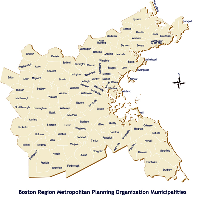
The Boston Region MPO is a 22-member board consisting of state agencies, regional organizations, and municipalities; its jurisdiction extends from Boston to Ipswich on the north, Duxbury on the south, and approximately to Interstate 495 on the west. The 101 cities and towns that make up this area are shown on the map that follows the title page of this document.
As part of its 3C process, the Boston Region MPO annually produces the Transportation Improvement Program (TIP) and the Unified Planning Work Program (UPWP). These documents, along with the Long-Range Transportation Plan (LRTP), are required in order for its process to be certified as meeting federal requirements; this certification is a prerequisite for the receipt of federal transportation funds.
This TIP was developed and approved by the MPO members listed below. The permanent MPO voting members are the Massachusetts Department of Transportation (MassDOT); Metropolitan Area Planning Council (MAPC); MBTA Advisory Board; Massachusetts Bay Transportation Authority (MBTA); Massachusetts Port Authority (Massport); City of Boston, and Regional Transportation Advisory Council. The elected MPO voting members and their respective seats are:
City of Beverly – North Shore Task Force
City of Everett – At-Large City
City of Newton – At-Large City
City of Somerville – Inner Core Committee
City of Woburn – North Suburban Planning Council
Town of Arlington – At-Large Town
Town of Bedford – Minuteman Advisory Group on Interlocal Coordination
Town of Braintree – South Shore Coalition
Town of Framingham – MetroWest Regional Collaborative
Town of Lexington – At-Large Town
Town of Medway – SouthWest Advisory Planning Committee
Town of Norwood – Three Rivers Interlocal Council
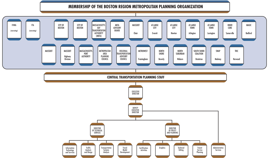
In addition, the Federal Highway Administration (FHWA) and the Federal Transit Administration (FTA) participate in the MPO as advisory (nonvoting) members. The chart on the following page also shows the MPO membership and the organization of the MPO’s staff, the Central Transportation Planning Staff.
Two members participate in the Boston Region MPO in an advisory (nonvoting) capacity, reviewing the Long-Range Regional Transportation Plan (LRTP), the Transportation Improvement Program (TIP), and the Unified Planning Work Program (UPWP) to ensure compliance with federal planning and programming requirements:
Two other entities assist MPO members in carrying out the responsibilities of the MPO’s 3C planning process through policy implementation, technical support, and public participation:
The following section is a brief description of each of the three documents the MPO produces as part of its federally required 3C process:
This legislation requires all MPOs to carry out the 3C process. Activities the MPOs must perform to meet this requirement are:
The MAP-21 legislation establishes national goals for federal highway programs. These goals include:
MAP-21 also establishes performance-based planning as an integral part of the metropolitan planning process. Under MAP-21, states will develop performance goals, guided by the national goals set out in MAP-21, and MPOs will work with state DOTs in developing MPO performance targets. The TIP will integrate the MPO’s performance measures and link transportation investment decisions to progress toward the achievement of performance goals.
The Boston Region Metropolitan Planning Organization (MPO) complies with Title VI of the Civil Rights Act of 1964, the Americans with Disabilities Act (ADA), and other federal and state nondiscrimination statutes and regulations in all programs and activities. The MPO does not discriminate on the basis of race, color, national origin, English proficiency, income, religious creed, ancestry, disability, age, gender, sexual orientation, gender identity or expression, or military service. The major federal requirements are discussed below.
This statute requires that no person be excluded from participation in, be denied the benefits of, or be subjected to discrimination on the basis of race, color, national origin, under any program or activity provided by an agency receiving federal financial assistance.
Executive Order 13166, dated August 11, 2000, extends Title VI protections to persons who, as a result of national origin, have limited English-language proficiency (LEP). Specifically, it calls for improved access to federally conducted and federally assisted programs and activities and requires MPOs to develop and implement a system by which LEP persons can meaningfully participate in the transportation-planning process.
Executive Order 12898, dated February 11, 1994, further expands upon Title VI, requiring each federal agency to achieve environmental justice by identifying and addressing any disproportionately high adverse human health or environmental effects, including interrelated social and economic effects, of its programs, policies, and activities on minority or low-income populations.
On April 15, 1997, the U.S. Department of Transportation issued its Final Order to Address Environmental Justice in Minority Populations and Low-Income Populations. Among other provisions, this order requires programming and planning activities to:
Title III of the Americans with Disabilities Act requires all transportation projects, plans, and programs to be accessible to people with disabilities. At the MPO level, this means that public meetings must be held in accessible buildings and MPO materials must be made available in accessible formats.
Air quality conformity determinations must be performed for capital improvement projects that receive federal funding and for those that are considered regionally significant, regardless of the funding source. These determinations must show that the MPO’s LRTP and TIP will not cause or contribute to any new air quality violations, will not increase the frequency or severity of any existing air quality violations in any area, and will not delay the timely attainment of the air quality standards in any area.
Transportation control measures (TCMs) identified in the State Implementation Plan (SIP) for the attainment of air quality standards are federally enforceable and must be given first priority when using federal funds. Such projects include parking freeze programs in Boston and Cambridge, statewide rideshare programs, rapid transit and commuter rail extension programs, park-and-ride facilities, residential parking sticker programs, and the operation of high-occupancy-vehicle lanes.
The Global Warming Solutions Act (GWSA), which Governor Deval Patrick signed into law in August 2008, makes Massachusetts a leader in setting aggressive and enforceable greenhouse gas (GHG) reduction targets and implementing policies and initiatives to achieve these targets. In keeping with this law, the Massachusetts Executive Office of Energy and Environmental Affairs (EOEEA), in consultation with other state agencies and the public, developed the Massachusetts Clean Energy and Climate Plan for 2020. This implementation plan, released on December 29, 2010, establishes the following targets for overall, statewide GHG emissions:
The transportation sector is the single largest contributor of greenhouse gases, accounting for over a third of GHG emissions, and is therefore a key focus of the Clean Energy and Climate Plan for 2020. MassDOT’s approach to supporting the implementation of the plan is set forth in its GreenDOT Policy Directive, a comprehensive sustainability initiative that sets three principal objectives:
The Commonwealth’s 13 MPOs are integrally involved in helping to achieve the GreenDOT objectives and supporting the GHG reductions mandated under the GWSA. The MPOs seek to achieve these objectives through the prioritization of projects in the LRTP and TIP. The Boston Region MPO’s TIP project evaluation criteria score projects based on greenhouse gas (GHG) emissions impacts, multimodal “complete streets” accommodations, and their ability to support smart-growth development. Tracking and evaluating GHG emissions by project will enable the MPOs to identify the anticipated GHG impacts of the planned and programmed projects and also to use GHG impacts as a criterion in prioritizing transportation investments.
The MPO considered the degree to which a proposed TIP project would advance the policies that guided the development of its LRTP. The MPO also reviewed TIP projects within the context of the recommended projects included in the LRTP.
The MPO aims to implement the recommendations of past studies and reports of the UPWP. This information was considered by the MPO in the development of the draft TIP.
The purpose of the CMP is to monitor transit, roadway, park-and-ride facilities, and bicycle and pedestrian facilities in the MPO region and identify “problem” locations. Projects that help address problems identified in the most recent CMP monitoring were considered for inclusion in this TIP.
In 2009, the MBTA adopted its current PMT, which is the MBTA’s long-range capital plan. The PMT was developed with extensive public involvement and was approved by the MBTA Advisory Board. The PMT includes projects that are currently under design for inclusion in the TIP.
youMove Massachusetts, a statewide initiative designed as a bottom-up approach to transportation planning, developed 10 core themes derived from a broad-based public participation process that articulated the expressed concerns, needs, and aspirations of Massachusetts residents related to their transportation network. These themes formed the basis for the You Move Massachusetts Interim Report (2009), and were considered in the development of this TIP.
weMove Massachusetts (WMM) is MassDOT’s statewide strategic multimodal plan. The initiative is a product of the transportation reform legislation of 2009 and the You Move Massachusetts civic engagement process. WMM will improve how MassDOT does business, responds to customers, and provides transportation services to the commonwealth. Using an analytical approach developed for the WMM process, MassDOT can now prioritize transportation investments for different planning scenarios based on national standards and available funds. The TIP builds on this data-based effort to prioritize transportation investments.
The Healthy Transportation Compact (HTC) is a key requirement of the Massachusetts landmark transportation reform legislation that took effect on November 1, 2009. It is an interagency initiative that will help ensure that the transportation decisions the Commonwealth makes balance the needs of all transportation users, expand mobility, improve public health, support a cleaner environment, and create stronger communities.
The agencies work together to achieve positive health outcomes through the coordination of land use, transportation, and public health policy. HTC membership is made up of the Secretary of Transportation or designee (co-chair), the Secretary of Health and Human Services or designee (co-chair), the Secretary of Energy and Environmental Affairs or designee, the Administrator of Transportation for Highways or designee, the Administrator of Transportation for Mass Transit or designee, and the Commissioner of Public Health or designee.
The HTC also promotes improved coordination among the public sector, private sector, and advocacy groups, as well as among transportation, land-use, and public health stakeholders. As part of the framework for the HTC, MassDOT established a Healthy Transportation Advisory Group comprising advocates and leaders in the fields of land-use, transportation, and public health policy.
The $3 billion Patrick-Murray Accelerated Bridge Program (ABP) represents a monumental investment in Massachusetts bridges. This program will greatly reduce the number of structurally deficient bridges in the state system, while creating thousands of construction jobs on bridge projects.
To complete this program, MassDOT and the Department of Conservation and Recreation (DCR) have relied on the use of innovative and accelerated project development and construction techniques. As a result, projects have been completed on time, on budget, and with minimum disruption to people and to commerce.
Since 2008, the number of former structurally deficient bridges has dropped, from 543 to 436, a decline of 19.7 percent. As of January 1, 2013, the ABP Program has completed 121 bridge projects, with another 48 bridge projects currently in construction and an additional 20 bridge projects scheduled to start construction within the next year. Over the course of the eight-year ABP program, it is expected that more than 200 bridges will be replaced or repaired.
In the fall of 2012, MassDOT announced a statewide mode shift goal of tripling the share of travel in Massachusetts that uses the modes of bicycling, transit, and walking. The mode shift goal aims to foster improved quality of life by improving our environment and preserving the capacity on our highway network. In addition, positive public health outcomes will be achieved by providing more healthy transportation options.
In choosing projects for inclusion in the TIP, the Boston Region MPO considers the degree to which a project forwards the following MPO policies, which were adopted in April 2010, and are the basis for the TIP evaluation process:
Maximizing efficiency, reliability, mobility, and accessibility with our existing infrastructure and within current and ongoing fiscal constraints will require following a program of strategic, needs-based investments. To accomplish this, the MPO will put a priority on programs, services, and projects that:
To make livability a hallmark of communities in the MPO region and to achieve mobility, foster sustainable communities, and expand economic opportunities and prosperity, the MPO will put a priority on programs, services, and projects that:
To improve mobility for people and freight, the MPO will put a priority on programs, services, and projects that:
To protect the environment and minimize the impacts from transportation systems, the MPO will put a priority on programs, services, and projects that:
To provide for the equitable sharing of the benefits and burdens of transportation investments among all residents of the region, the MPO will put a priority on programs, services, and projects that:
To meet the targets for reducing GHG emissions, the MPO will put a priority on programs, services, and projects that:
To provide for maximum transportation safety and to support security in the region, the MPO will put a priority on programs, services, and projects that:
Among the most important decisions faced in planning for the future are those involving how to spend scarce funds to achieve the best transportation value. Transportation is part of the solution to many critical regional, state, national, and even global problems, such as traffic congestion, air pollution, traffic fatalities and injuries, climate change, and environmental justice. With not nearly enough transportation funding available to build all of the needed and worthy projects to address these problems, investments should be guided by policies that help identify the strongest solutions. The TIP seeks to prioritize these transportation investments through its annual development process.
Each year, the MPO conducts a TIP development process to decide how to spend federal transportation funds for capital projects. The Central Transportation Planning Staff to the Boston Region MPO manages the annual development process for the TIP. The MPO staff coordinates the evaluation of project requests, propose programming of current and new projects based on anticipated funding levels, support the MPO in the development a draft document, and facilitate public review of the draft document before the final MPO endorsement.
The first step in the process of allocating federal transportation funds is for a multiyear transportation authorization act to establish a maximum level of federal transportation funding per federal fiscal year. The establishment of this level of funding is referred to as an authorization. The most recent authorization act is Moving Ahead for Progress in the 21st Century (MAP-21), signed into law on July 6, 2012.
Once the authorization level has been established, the United States Department of Transportation annually allocates funding among the states, based on various federal formulas. This allocation is referred to as an apportionment. The annual apportionment rarely represents the actual amount of federal funds that is committed to a state, due to federally imposed limitations on spending in a given fiscal year called obligation authority.
Obligation authority may be imposed in a multiyear authorization act, in the annual appropriations act, or in both. Obligation authority is typically less than a state’s apportionment. In Massachusetts, TIPs are developed based on the estimated obligation authority.
Two of the most important distinctions between apportionment and obligation authority are: (1) apportionment is allocated on a per-program basis, while obligation authority is generally allocated as a lump sum; and (2) unused apportionment carries forward into successive federal fiscal years (FFYs), but unused obligation authority does not. Unused apportionment that is carried forward is referred to as an unobligated balance. Although a state’s unobligated balance can be used to increase the federal aid programmed within a particular funding category in a given FFY, it cannot be used to increase the total amount of the state’s highway apportionment.
Federal regulations require states to “provide MPOs with estimates of Federal and State funds which the MPOs shall utilize in developing financial plans” for TIPs. 3 The FFYs 2014–17 TIP was developed under the assumption that the Statewide Federal Highway Program would be $600 million annually over the next four years. In Massachusetts, federal highway program funding is allocated to several major funding categories. First, MassDOT allocates federal funding to Grant Anticipation Notes (GANs) payments for the Central Artery/Tunnel project in FFY 2014 and the Accelerated Bridge Program in FFYs 2015–17. Over the four years of this TIP, approximately $122.8 million of the Highway Program is dedicated to GANs payments for the Central Artery/Tunnel project and $450 million in federal aid is dedicated to GANs payments for the Accelerated Bridge Program. MassDOT matches the remaining amount of federal funding at an 80 percent (federal) and 20 percent (state) split. Next, funding is allocated to the following funding categories prioritized by MassDOT:
After these needs are satisfied, the remaining federal funding is allocated to the state’s MPOs for programming. This discretionary funding for MPOs is suballocated by formula to determine “regional target” amounts. These targets are developed in consultation with the Massachusetts Association of Regional Planning Agencies. Each MPO can decide how the Regional Target funding is prioritized. Over the next four years, the Boston Region MPO’s total Regional Target Program is approximately $296.8 million, or on average $74.1 million annually. To decide how to spend its Regional Target, the Boston Region MPO engages its 101 cities and towns in an annual development process for this decision making.
The Federal Transit Program is allocated within the Boston Urbanized Area (UZA) by formula to the transit operators. The formula considers passenger-miles, population density, and other factors associated with each transit provider. There are three regional transit authorities (RTAs) in the Boston MPO region: the Massachusetts Bay Transportation Authority (MBTA), the MetroWest Regional Transit Authority (MWRTA), and the Cape Ann Transportation Authority (CATA). The MBTA, with its extensive transit program and infrastructure, is the recipient of the preponderance of federal transit funds in the region.
Many federal-aid transportation programs support transportation activities in metropolitan areas, each having different requirements and program characteristics. Non-federal aid (state funds) for the Statewide Infrastructure Items, Bridge Program, and Central Artery/Tunnel project, is derived from various sources, including the Commonwealth’s Transportation Bond Bill. Under MAP-21, federal programs that fund projects in the FFYs 2014–17 TIP are listed in the following two tables.
TABLE 2-1
Federal Transit Administration Programs
MAP-21 Program |
Eligible Uses |
Examples |
|---|---|---|
Urbanized Area Formula Grants (Section 5307) |
Transit capital and operating assistance in urbanized areas. Under MAP-21, job access and reverse-commute activities (formerly funded under Section 5316) are now eligible for funding under Section 5307. |
Red/Orange Lines – New Vehicle Procurement (MBTA Revenue Vehicles) – FFYs 2014–17 |
Fixed Guideway/Bus (Section 5337) [Replaces the Fixed Guideway Modernization Program (Section 5309)] |
Replacement, rehabilitation, and other state-of-good-repair capital projects. |
Red Line Floating Slab (MBTA Track/Right-of-Way Program) – FFY 2014 |
Bus and Bus Facilities (Section 5339) |
Capital projects to replace, rehabilitate, and purchase buses and related equipment, and to construct bus-related facilities. |
MBTA Systems Upgrades Program – FFYs 2014–17 |
Enhanced Mobility of Seniors and Individuals with Disabilities (Section 5310) |
Capital expenses that support transportation to meet the special needs of older adults and persons with disabilities. Under MAP-21, New Freedom program (Section 5317) activities are now eligible under Section 5310. |
Coordination of Non-Emergency Human Service Transportation (Mystic Valley Elder Services) – FFY 2014 |
TABLE 2-2
Federal Highway Administration Programs
MAP-21 Program |
Eligible Uses |
Examples |
|---|---|---|
Congestion Mitigation and Air Quality Improvement (CMAQ) |
A wide range of projects in air quality nonattainment and maintenance areas for ozone, carbon monoxide, and small particulate matter that reduce transportation-related emissions. |
Lebanon Street (Melrose) – FFY 2014 |
Highway Safety Improvement Program (HSIP) |
Implementation of infrastructure-related highway safety improvements |
Route 2/Crosby’s Corner (Concord & Lincoln) – FFY 2014 |
National Highway Performance Program (NHPP) [Replaces the National Highway System (NHS) and Interstate Maintenance (IM) Programs, and a portion of the Bridge Program] |
Improvements to interstate routes, major urban and rural arterials, connectors to major intermodal facilities, and the national defense network. Also includes replacement or rehabilitation of any public bridge, and resurfacing, restoring, and rehabilitating routes on the interstate highway system. |
Route 128 Improvement Program (Needham & Wellesley) – FFYs 2014–17 Washington Avenue Bridge Replacement (Chelsea) – FFY 2014 |
Surface Transportation Program (STP) [Replaces a portion of the Bridge Program] |
A broad range of surface transportation capital needs, including many roads; transit, sea, and airport access; and vanpool, bicycle, and pedestrian facilities. |
Rantoul Street/Route 1A (Beverly) – FFY 2014 |
Transportation Alternatives Program (TAP) [Replaces the Transportation Enhancements, Recreational Trails, and Safe Routes to School Programs] |
Construction of infrastructure-related projects (e.g., sidewalk, crossing, and on-road bicycle facility improvements). Under MAP-21, Safe Routes to School and Recreational Trails projects are now eligible under TAP. |
Downey Elementary School (Westwood) – FFY 2014 |
High-Priority Projects (HPP) [Carryover from SAFETEA-LU] |
Named projects for which funds are specifically identified from previous authorizations. |
Gainsborough & St. Botoloph Sts. (Boston) – FFY 2014 |
Discretionary Funding |
Specific projects in annual appropriations funded through grant programs such as Transportation, Community and System Preservation Program, Value Pricing Pilot Program, and Transportation Infrastructure Finance and Innovation Act Program. |
|
The MPO’s project selection process for its highway discretionary (“regional target”) funding uses evaluation criteria to help identify and prioritize projects that advance the MPO’s goals. The criteria are based on the MPO’s visions and policies that were adopted for its Long-Range Transportation Plan, Paths to a Sustainable Region.
All projects are required to show consistency with the Long-Range Transportation Plan and other statewide and regional plans (for example, the Program for Mass Transportation and the Massachusetts Statewide Bicycle Transportation Plan).
The MPO staff evaluates each project that is considered for inclusion in the TIP based on the specific criteria that have been developed by the MPO. Other inputs include project readiness and municipal support. Additional background information on the TIP project evaluation process is provided in Appendix B of this document and on the MPO’s website, http://bostonmpo.org/Drupal/tip. The MPO reviews the effectiveness of this evaluation method and makes alterations to the process as appropriate.
The outreach process begins early in the fiscal year, when the MPO staff begins to brief local officials and members of the public on the year’s development process. In December, the MPO staff solicits a listing of priority projects to be considered for federal funding from each of the 101 cities and towns in the region. The MPO also seeks the input from interested parties and members of the general public. The staff then compiles the project funding requests and relevant information into a Universe of Projects list for the MPO. The Universe of Projects list consists of all identified projects being advanced for possible funding and includes projects in varied stages of development, from being in the conceptual stage to being fully designed and ready to be advertised for construction.
New projects must be initiated through the MassDOT Highway Division before they can be considered for programming in the TIP. Details of the project initiation process and relevant documents can be found on the Project Review Committee webpage, http://www.mhd.state.ma.us/default.asp?pgid=content/projectReview&sid=about. Municipal TIP Contacts and the MPO staff coordinate to update each project´s Project Funding Application Form through the MPO´s Interactive TIP Database, http://www.bostonmpo.org/apps/tip9/tip_query.html. The form provides information on each project´s background, infrastructure condition and needs, development status, and ability to help the region attain the visions established by the MPO.
More information on the Project Funding Application Forms can be found in Appendix B of this document.
The MPO has begun to monitor the anticipated greenhouse gas (GHG) emission impacts of planned and programmed projects. This tracking will enable the MPO to consider the anticipated impacts when prioritizing transportation investments. More information on the GHG emission monitoring and evaluation can be found in Appendix C of this document.
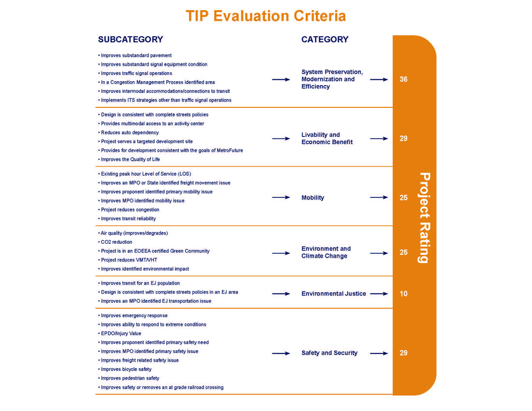
The MPO uses TIP project evaluation criteria to develop a numeric score that gives an indication of how well each project helps the region attain the visions established by the MPO. This score can then be used to guide the MPO in selecting the projects that will be most successful. The MPO’s visions include: to maintain a state of good repair, focus investments on existing activity centers, improve mobility for people and freight, reduce the level of greenhouse gas (GHG) emissions, minimize environmental burdens from transportation facilities on low-income and minority populations, and provide safe transportation for all modes. Projects with components and outcomes that help attain the goals of the MPO receive higher scores.
The project evaluation criteria consist of 35 questions across six policy categories. The TIP evaluation criteria graphic on page 2-7 provides an overview of the policy categories, their point values, and the criteria measures.
The MPO staff requires a Functional Design Report (FDR) to conduct a complete evaluation (see MassDOT’s Project Development and Design Guide for information about what is included in a Functional Design Report). If not enough information is available, a project cannot be fully evaluated across all categories.
The summary of evaluation results for projects being considered for the federal fiscal years (FFYs) 2014–17 TIP is available in table A-1 of Appendix A. The table contains the total project rating for each project. For more details on the evaluation criteria used to score projects, see Appendix B.
The MPO staff uses evaluations and project readiness information to prepare a First-Tier List of Projects. This is a list of the projects with the highest ratings that could be made ready for advertising within the TIP’s time horizon (the next four federal fiscal years). The staff relies on the MassDOT Highway Division to provide information about what year a project would be ready for advertising. In developing the staff recommendation for the draft TIP, the MPO staff strongly considers the First-Tier List of Projects. The MPO staff also factors in projects that are listed in the Long-Range Transportation Plan (LRTP) in order to implement the LRTP, considers geographic equity to help ensure that the list of projects addresses needs throughout the region, and accounts for cost to comply with fiscal constraint.
The project selection criteria for the Bridge Program are based on a continuous, ongoing prioritization process of MassDOT. The underlying basis for this prioritization is the condition of the bridges based largely on information gathered through the Bridge Inspection Management System.
The project selection process for the Statewide Infrastructure Items involves coordination between the MassDOT divisions to review and prioritize projects that advance important statewide policy goals for improving mobility, protecting the environment, promoting economic growth, and improving public health and quality of life. Other prioritization factors include project readiness and consistency with MassDOT’s GreenDOT sustainability policy, the Bay State Greenway Priority 100, and the Safe Routes to School Program.
The process of selecting transit projects for the TIP draws primarily from the Massachusetts Bay Transportation Authority (MBTA) Capital Investment Program (CIP). The CIP is a rolling five-year plan that outlines the transit system´s infrastructure needs and planned investments within that short-range time frame. The MBTA updates the CIP annually. Prioritization of projects for inclusion in the CIP is based on their impacts on the following, as defined in the MBTA’s enabling legislation: the effectiveness of the commonwealth’s transportation system; service quality; the environment, health, and safety; the state of good repair of MBTA infrastructure; and the MBTA’s operating costs and debt service.
Projects that receive the highest priority are those with the greatest benefit and the least cost, as prioritized by the following criteria:
The transit element of the TIP also includes the federal-aid programs of the other two transit authorities in the region, the Cape Ann Transportation Authority (CATA) and MetroWest Regional Transit Authority (MWRTA). CATA and MWRTA coordinate with the MassDOT Rail and Transit Division to develop their capital programs.
The MPO considers the evaluation results, First-Tier List of Projects, and staff recommendation in prioritizing projects for Regional Target funding. They also consider public input, regional importance, and other factors in the development of the draft TIP. In addition to prioritizing the Regional Target funding, the MPO also reviews the Statewide Infrastructure Items and Bridge Programs, and the capital programs for the MBTA, CATA, and MWRTA, before voting to release a draft TIP for public review.
This year, the MPO voted in early May to release the draft federal fiscal years (FFYs) 2014–17 TIP for a 30-day public review and comment period. The MPO invites members of the public, regional and local officials, and other stakeholders from the Boston region to review the proposed program. Several TIP outreach sessions are held during the public comment period to solicit comments on the draft TIP. Summaries of comments received on the draft TIP are provided in Appendix F.
After the comment period ends, the MPO reviews all comments and makes changes to the document as appropriate. This year the MPO is scheduled to take action on the draft FFYs 2014–2017 TIP on June 27, 2013. Once the TIP is endorsed by the MPO, it is incorporated into the State Transportation Improvement Program (STIP) and sent to the Federal Highway Administration and Federal Transit Administration to enable federal approval by September 30, the end of the federal fiscal year.
The TIP is a dynamic program that is amended and adjusted throughout the year. Administrative modifications and amendments often must be introduced due to changes in project status, project cost, or available revenues.
Consistent with federal guidelines, if a project is valued at $5 million or less, the threshold for defining an amendment is a change of $500,000 or more. The threshold for projects valued at greater than $5 million is 10 percent or more of the project value. Changes below these thresholds may be considered administrative modifications. The MPO acts on administrative modifications, and, although no public review period is required, one may be provided at the MPO’s discretion.
Affected municipalities and constituencies are notified of pending amendments. Legal notices of amendments are placed in the region’s major newspaper, in its most widely read minority newspaper and Spanish-language newspaper, and on the MPO’s website. In addition, a notice of a pending amendment is distributed to the MPO’s email listserv, MPOinfo, and, along with the actual amendment, is posted on its website. These notices include information on a 30-day public comment period that precedes MPO action on the amendment. The Regional Transportation Advisory Council is notified and briefed during this period and provides its comments. Municipal representatives and members of the public may also submit written or oral testimony at MPO meetings at which amendments are discussed.
Because the print version of the TIP is prepared prior to the start of each federal fiscal year, it may not reflect all of the changes to the program and projects that occur during the course of the year. The MPO’s website is the best place to find current information about the TIP.
All actions on the draft TIP and the approved actions on the endorsed TIP are available on the TIP webpage on the MPO’s website, http://ctps.org/Drupal/tip. Comments or questions on the draft materials may be submitted directly through the website.
This chapter begins with tables listing, by year, the projects and programs funded in FFYs 2014–17.
Following the tables, information on projects and programs funded in the Highway and Transit Programs is presented. Projects funded under the Highway Program are listed by municipality, while programs funded under the Transit Program are listed by transit agency.
ID Number: Projects in MassDOT’s project-tracking system are given a number; those projects not in the
Project-tracking system have no number. Transit projects are identified by regional transit agency.
Municipality(ies): The municipality (or municipalities) in which a project is located.
Project Name: The location or name of the project.
Project Type: The category of the project (e.g., Major Highway, Arterial and Intersection, or Bicycle and Pedestrian).
Air Quality Status: The air quality status of the project in the MPO’s regional travel demand model.
CO2 Impact: The quantified or assumed annual tons of carbon dioxide reduced by the project.
See Appendix C for more details on greenhouse gas (GHG) emission monitoring and evaluation.
Evaluation Rating: The number of points scored by the project based on the evaluation criteria, if it has been evaluated.
MPO/CTPS Study: Past UPWP-funded studies or reports conducted within the project area.
LRTP Status: The time band that the project is listed in the Long-Range Transportation Plan, if applicable.
Project Length: The length of the project in miles.
Project Description: The description of the project, if available.
Year: The programming year(s) of the project.
Funding Program: The funding program(s) of the project. See Chapter 2 for more details on funding programs.
Total Funding Programmed: The total funding programmed for the project based on the year of expenditure.
Information regarding TIP projects changes periodically. For more information on all projects please visit the Interactive TIP Database at www.ctps.org.
| Project Name | PROJIS | TIP Year | Primary Source | Total Funds | Federal Funds | Non-Federal Funds |
Additional Information | Analysis of GHG Impact | TIP Document |
|---|---|---|---|---|---|---|---|---|---|
| RANDOLPH- QUINCY- BRAINTREE - RESURFACING AND RELATED WORK ON I-93 | 607481 | 2017 | IM | $11,365,760 | $10,229,184 | $1,136,576 | N/A | No Co2 Impact | Draft FFYs 2014-17 |
| LYNNFIELD- PEABODY - RESURFACING AND RELATED WORK ON ROUTE 1 | 607477 | 2017 | NHSPP | $6,444,386 | $5,155,509 | $1,288,877 | N/A | No Co2 Impact | Draft FFYs 2014-17 |
| BURLINGTON- CHELMSFORD- VARIOUS LOCATION PAVEMENT PRESERVATION ON ROUTE 3 | 607472 | 2014 | NHSPP | $4,446,000 | $3,556,800 | $889,200 | N/A | No Co2 Impact | Draft FFYs 2014-17 |
| WESTWOOD- SAFE ROUTES TO SCHOOL (DOWNEY ELEMENTARY) | 607449 | 2014 | SRTS | $686,250 | $549,000 | $137,250 | N/A | Assumed Nominal Reduction in CO2 from Bicycle and Pedestrian Infrastructure | Draft FFYs 2014-17 |
| MALDEN- SAFE ROUTES TO SCHOOL (BEEBE SCHOOL) | 607447 | 2014 | SRTS | $577,500 | $462,000 | $115,500 | N/A | Assumed Nominal Reduction in CO2 from Bicycle and Pedestrian Infrastructure | Draft FFYs 2014-17 |
| MANCHESTER- SAFE ROUTES TO SCHOOL (MEMORIAL ELEMENTARY) | 607441 | 2014 | SRTS | $625,000 | $500,000 | $125,000 | N/A | Assumed Nominal Reduction in CO2 from Bicycle and Pedestrian Infrastructure | Draft FFYs 2014-17 |
| COHASSET- SUPERSTRUCTURE REPLACEMENT & SUBSTRUCTURE REHABILITATION, C-17-002, ATLANTIC AVENUE OVER LITTLE HARBOR INLET | 607345 | 2016 | Bridge | $5,044,568 | $4,035,654 | $1,008,914 | N/A | No Co2 Impact | Draft FFYs 2014-17 |
| GLOUCESTER- BRIDGE PRESERVATION, G-05-017, ROUTE 128 OVER ANNISQUAM RIVER (PHASE II) | 607338 | 2014 | Bridge | $8,450,000 | $6,760,000 | $1,690,000 | AC Yr 1 of 2; Total Cost = $17,250,000 | Assumed Nominal Reduction in CO2 from Bicycle Infrastructure | Draft FFYs 2014-17 |
| GLOUCESTER- BRIDGE PRESERVATION, G-05-017, ROUTE 128 OVER ANNISQUAM RIVER (PHASE II) | 607338 | 2015 | Bridge | $8,800,000 | $7,040,000 | $1,760,000 | AC Yr 2 of 2; Total Cost = $17,250,000 | Assumed Nominal Reduction in CO2 from Bicycle Infrastructure | Draft FFYs 2014-17 |
| FRANKLIN- BRIDGE DEMOLITION, F-08-005, OLD STATE ROUTE 140 OVER MBTA/CSX & NEW PEDESTRAIN BRIDGE CONSTRUCTION | 607273 | 2015 | Bridge | $1,780,272 | $1,424,218 | $356,054 | N/A | Assumed Nominal Reduction in CO2 from Bicycle Infrastructure | Draft FFYs 2014-17 |
| CHELSEA- REVERE- RESURFACING & RELATED WORK ON ROUTE 1 | 607174 | 2015 | NHSPP | $8,643,660 | $6,914,928 | $1,728,732 | N/A | No Co2 Impact | Draft FFYs 2014-17 |
| QUINCY- BRIDGE REPLACEMENT, ROBERTSON STREET OVER I-93/US 1/SR 3 | 607133 | 2016 | Bridge | $4,928,663 | $3,942,930 | $985,733 | N/A | No Co2 Impact | Draft FFYs 2014-17 |
| BOSTON- IMPROVEMENTS ALONG GAINSBOROUGH AND ST. BOTOLPH STREETS | 606889 | 2014 | Earmark | $1,012,389 | $809,911 | $202,478 | Construction; HPP 2012; SAFETEA-LU Earmark + HPP TI 180 Earmark Total Cost = $3,518,243 | Assumed Nominal Reduction in CO2 from Bicycle and Pedestrian Infrastructure | Draft FFYs 2014-17 |
| BOSTON- IMPROVEMENTS ALONG GAINSBOROUGH AND ST. BOTOLPH STREETS | 606889 | 2014 | Earmark | $2,505,854 | $2,004,683 | $501,171 | Construction; HPP 2012; SAFETEA-LU Earmark + HPP TI 180 Earmark Total Cost = $3,518,243 | Assumed Nominal Reduction in CO2 from Bicycle and Pedestrian Infrastructure | Draft FFYs 2014-17 |
| ARLINGTON- BIKEWAY CONNECTION AT INTERSECTION ROUTE 3 & ROUTE 60, MASSACHUSETTS AVENUE, PLEASANT STREET & MYSTIC STREET | 606885 | 2014 | CMAQ | $1,618,954 | $1,295,163 | $323,791 | N/A | 294 | Draft FFYs 2014-17 |
| WEYMOUTH- BRAINTREE- QUINCY - RESURFACING & RELATED WORK ON ROUTE 3 | 606639 | 2014 | NHSPP | $9,912,000 | $7,929,600 | $1,982,400 | N/A | No Co2 Impact | Draft FFYs 2014-17 |
| HOPKINTON- WESTBOROUGH- BRIDGE REPLACEMENT, H-23-006=W-24-016, FRUIT STREET OVER CSX & SUDBURY RIVER | 606632 | 2016 | Bridge | $9,396,713 | $7,517,370 | $1,879,343 | N/A | No Co2 Impact | Draft FFYs 2014-17 |
| FRANKLIN- INTERSTATE MAINTENANCE & RELATED WORK ON I-495 | 606546 | 2016 | IM | $5,505,408 | $4,954,867 | $550,541 | N/A | No Co2 Impact | Draft FFYs 2014-17 |
| BOSTON- IMPROVEMENTS AT AUDUBON CIRCLE | 606460 | 2017 | CMAQ | $5,539,955 | $4,431,964 | $1,107,991 | N/A | Model | Draft FFYs 2014-17 |
| BURLINGTON- WOBURN- READING- EXPANSION OF FIBER, CCTV, VMS & TRAFFIC SENSOR NETWORK ON I-95 | 606432 | 2014 | Statewide ITS | $5,000,000 | $4,000,000 | $1,000,000 | N/A | Assumed Nominal Reduction in CO2 from Bicycle and Pedestrian Infrastructure | Draft FFYs 2014-17 |
| BOSTON- IMPROVEMENTS TO COMMONWEALTH AVENUE, FROM AMORY STREET TO ALCORN STREET | 606284 | 2015 | STP | $7,446,852 | $5,957,482 | $1,489,370 | STP+CMAQ+Earmarks (SAFETEA-LU, Section 125 and 129, STPP, TCSP) Total Cost = $16,866,250 | 57 | Draft FFYs 2014-17 |
| BOSTON- IMPROVEMENTS TO COMMONWEALTH AVENUE, FROM AMORY STREET TO ALCORN STREET | 606284 | 2015 | CMAQ | $5,000,000 | $4,000,000 | $1,000,000 | STP+CMAQ+Earmarks (SAFETEA-LU, Section 125 and 129, STPP, TCSP) Total Cost = $16,866,250 | 57 | Draft FFYs 2014-17 |
| BOSTON- IMPROVEMENTS TO COMMONWEALTH AVENUE, FROM AMORY STREET TO ALCORN STREET | 606284 | 2015 | Earmark | $1,114,501 | $891,601 | $222,900 | Construction; HPP 682; STP+CMAQ+Earmarks (SAFETEA-LU, Section 125 and 129, STPP, TCSP) Total Cost = $16,866,250 | 57 | Draft FFYs 2014-17 |
| BOSTON- IMPROVEMENTS TO COMMONWEALTH AVENUE, FROM AMORY STREET TO ALCORN STREET | 606284 | 2015 | Earmark | $980,000 | $980,000 | $- | Construction; Section 129; STP+CMAQ+Earmarks (SAFETEA-LU, Section 125 and 129, STPP, TCSP) Total Cost = $16,866,250 | 57 | Draft FFYs 2014-17 |
| BOSTON- IMPROVEMENTS TO COMMONWEALTH AVENUE, FROM AMORY STREET TO ALCORN STREET | 606284 | 2015 | Earmark | $475,000 | $475,000 | $- | Construction; Section 125; STP+CMAQ+Earmarks (SAFETEA-LU, Section 125 and 129, STPP, TCSP) Total Cost = $16,866,250 | 57 | Draft FFYs 2014-17 |
| BOSTON- IMPROVEMENTS TO COMMONWEALTH AVENUE, FROM AMORY STREET TO ALCORN STREET | 606284 | 2015 | Discretionary | $599,897 | $599,897 | $- | Construction; STPP; STP+CMAQ+Earmarks (SAFETEA-LU, Section 125 and 129, STPP, TCSP) Total Cost = $16,866,250 | 57 | Draft FFYs 2014-17 |
| BOSTON- IMPROVEMENTS TO COMMONWEALTH AVENUE, FROM AMORY STREET TO ALCORN STREET | 606284 | 2015 | Discretionary | $1,250,000 | $1,000,000 | $250,000 | Construction; TCSP; STP+CMAQ+Earmarks (SAFETEA-LU, Section 125 and 129, STPP, TCSP) Total Cost = $16,866,250 | 57 | Draft FFYs 2014-17 |
| ACTON- CONCORD- BRUCE FREEMAN RAIL TRAIL CONSTRUCTION (PHASE II-B) | 606223 | 2017 | Statewide CMAQ | $6,681,600 | $5,345,280 | $1,336,320 | N/A | 152 | Draft FFYs 2014-17 |
| FOXBOROUGH- PLAINVILLE- WRENTHAM- INTERSTATE MAINTENANCE & RELATED WORK ON I-495 (NB & SB) | 606176 | 2016 | IM | $15,257,117 | $13,731,405 | $1,525,712 | N/A | No Co2 Impact | Draft FFYs 2014-17 |
| SHARON- WALPOLE - INTERSTATE MAINTENANCE & RELATED WORK ON I-95 | 606171 | 2014 | IM | $9,912,000 | $8,920,800 | $991,200 | N/A | No Co2 Impact | Draft FFYs 2014-17 |
| BOSTON- TRAFFIC SIGNAL IMPROVEMENTS ON BLUE HILL AVENUE AND WARREN STREET | 606134 | 2015 | Earmark | $2,377,900 | $1,902,320 | $475,580 | Construction; HPP 2129 |
To Be Determined | Draft FFYs 2014-17 |
| BELLINGHAM- BRIDGE DEMOLITION, B-06-011, ROUTE 126 OVER CSX RAILROAD (ABANDONED) & INSTALLATION OF BIKE PATH CULVERT | 605895 | 2014 | Bridge | $1,705,200 | $1,364,160 | $341,040 | N/A | Assumed Nominal Reduction in CO2 from Bicycle Infrastructure | Draft FFYs 2014-17 |
| DEDHAM- BRIDGE REPLACEMENT, D-05-003 (33K), NEEDHAM STREET OVER GREAT DITCH | 605883 | 2015 | Bridge | $3,029,032 | $2,423,226 | $605,806 | N/A | Assumed Nominal Reduction in CO2 from Bicycle Infrastructure | Draft FFYs 2014-17 |
| BOSTON- RECONSTRUCTION OF MELNEA CASS BOULEVARD (HPP 756 & 4284) | 605789 | 2015 | Earmark | $2,429,730 | $1,943,784 | $485,946 | Construction; HPP 756; SAFETEA-LU Earmark (HPP 756)+ SAFETEA-LU Earmark (HPP 4284) =Total Cost $7,437,105 | To Be Determined | Draft FFYs 2014-17 |
| BOSTON- RECONSTRUCTION OF MELNEA CASS BOULEVARD (HPP 756 & 4284) | 605789 | 2015 | Earmark | $5,007,375 | $4,005,900 | $1,001,475 | Construction; HPP 4284; SAFETEA-LU Earmark (HPP 756)+ SAFETEA-LU Earmark (HPP 4284) =Total Cost $7,437,105 | To Be Determined | Draft FFYs 2014-17 |
| QUINCY- INTERSECTION & SIGNAL IMPROVEMENTS AT HANCOCK STREET & EAST/WEST SQUANTUM STREETS | 605729 | 2014 | CMAQ | $3,575,278 | $2,860,222 | $715,056 | 6 | Draft FFYs 2014-17 | |
| MEDWAY- RECONSTRUCTION ON ROUTE 109, FROM HOLLISTON STREET TO 100 FT. WEST OF HIGHLAND STREET, INCLUDES REHAB OF M-13-012 | 605657 | 2016 | STP | $3,275,569 | $2,620,455 | $655,114 | STP+HSIP+CMAQ Total Cost = $11,275,569 | 352 | Draft FFYs 2014-17 |
| MEDWAY- RECONSTRUCTION ON ROUTE 109, FROM HOLLISTON STREET TO 100 FT. WEST OF HIGHLAND STREET, INCLUDES REHAB OF M-13-012 | 605657 | 2016 | HSIP | $3,000,000 | $2,400,000 | $600,000 | STP+HSIP+CMAQ Total Cost = $11,275,569; HSIP pending Road Safety Audit | 352 | Draft FFYs 2014-17 |
| MEDWAY- RECONSTRUCTION ON ROUTE 109, FROM HOLLISTON STREET TO 100 FT. WEST OF HIGHLAND STREET, INCLUDES REHAB OF M-13-012 | 605657 | 2016 | CMAQ | $5,000,000 | $4,000,000 | $1,000,000 | STP+HSIP+CMAQ Total Cost = $11,275,569 | 352 | Draft FFYs 2014-17 |
| CONCORD- BRUCE FREEMAN RAIL TRAIL CONSTRUCTION (PHASE II-C) | 605189 | 2016 | Statewide CMAQ | $6,196,494 | $4,957,195 | $1,239,299 | N/A | To Be Determined | Draft FFYs 2014-17 |
| SALEM- RECONSTRUCTION ON CANAL STREET, FROM WASHINGTON STREET & MILL STREET TO LORING AVENUE & JEFFERSON AVENUE | 605146 | 2014 | STP | $2,574,201 | $2,059,361 | $514,840 | STP+HSIP+CMAQ Total Cost = $6,574,201 | 8 | Draft FFYs 2014-17 |
| SALEM- RECONSTRUCTION ON CANAL STREET, FROM WASHINGTON STREET & MILL STREET TO LORING AVENUE & JEFFERSON AVENUE | 605146 | 2014 | HSIP | $2,000,000 | $1,600,000 | $400,000 | STP+HSIP+CMAQ Total Cost = $6,574,201; HSIP pending Road Safety Audit | 8 | Draft FFYs 2014-17 |
| SALEM- RECONSTRUCTION ON CANAL STREET, FROM WASHINGTON STREET & MILL STREET TO LORING AVENUE & JEFFERSON AVENUE | 605146 | 2014 | CMAQ | $2,000,000 | $1,600,000 | $400,000 | STP+HSIP+CMAQ Total Cost = $6,574,201 | 8 | Draft FFYs 2014-17 |
| BROOKLINE- INTERSECTION & SIGNAL IMPROVEMENTS @ ROUTE 9 & VILLAGE SQUARE (GATEWAY EAST) | 605110 | 2015 | CMAQ | $4,375,971 | $3,500,777 | $875,194 | CMAQ+ Private Sector Contribution ($1,000,000) Total Cost = $5,375,971 | 22 | Draft FFYs 2014-17 |
| SOUTHBOROUGH- RECONSTRUCTION OF MAIN STREET (RTE 30), FROM SEARS ROAD TO PARK STREET | 604989 | 2017 | STP | $5,025,260 | $4,020,208 | $1,005,052 | N/A | Model | Draft FFYs 2014-17 |
| LYNN- SAUGUS- BRIDGE REPLACEMENT, L-18-016=S-05-008, ROUTE 107 OVER THE SAUGUS RIVER (AKA - BELDEN G. BLY BRIDGE) | 604952 | 2017 | Bridge | $7,200,000 | $5,760,000 | $1,440,000 | AC Yr 1; Total Cost = $41,432,760 ($7,200,000 programmed within FFYs 2014-17 TIP) | No Co2 Impact | Draft FFYs 2014-17 |
| WOBURN- RECONSTRUCTION OF MONTVALE AVENUE, FROM I-93 INTERCHANGE TO CENTRAL STREET (APPROX. 1,850 FT) | 604935 | 2017 | HSIP | $4,752,838 | $3,802,270 | $950,568 | HSIP pending Road Safety Audit | Model | Draft FFYs 2014-17 |
| MARLBOROUGH- RECONSTRUCTION OF ROUTE 85 (MAPLE STREET) | 604810 | 2015 | HSIP | $3,190,122 | $2,552,098 | $638,024 | HSIP+CMAQ Total Cost = $5,190,122; HSIP pending Road Safety Audit | 325 | Draft FFYs 2014-17 |
| MARLBOROUGH- RECONSTRUCTION OF ROUTE 85 (MAPLE STREET) | 604810 | 2015 | CMAQ | $2,000,000 | $1,600,000 | $400,000 | HSIP+CMAQ Total Cost = $5,190,122 | 325 | Draft FFYs 2014-17 |
| DEDHAM- BRIDGE REPLACEMENT, D-05-033, PROVIDENCE HIGHWAY OVER MOTHER BROOK | 604796 | 2014 | Bridge | $5,859,000 | $4,687,200 | $1,171,800 | AC Yr 1 of 2; Total Cost = $10,868,550 | Assumed Nominal Reduction in CO2 from Bicycle Infrastructure | Draft FFYs 2014-17 |
| DEDHAM- BRIDGE REPLACEMENT, D-05-033, PROVIDENCE HIGHWAY OVER MOTHER BROOK | 604796 | 2015 | Bridge | $5,009,550 | $4,007,640 | $1,001,910 | AC Yr 2 of 2; Total Cost = $10,868,550 | Assumed Nominal Reduction in CO2 from Bicycle Infrastructure | Draft FFYs 2014-17 |
| BOSTON- MULTI-USE TRAIL CONSTRUCTION (SOUTH BAY HARBOR) FROM RUGGLES STATION TO FAN PIER | 604761 | 2014 | TAP | $2,548,719 | $2,038,975 | $509,744 | Construction; CMAQ+TAP Total Cost = $4,197,981; TAP pending application approval | 846 | Draft FFYs 2014-17 |
| BOSTON- MULTI-USE TRAIL CONSTRUCTION (SOUTH BAY HARBOR) FROM RUGGLES STATION TO FAN PIER | 604761 | 2014 | CMAQ | $1,649,262 | $1,319,410 | $329,852 | Construction; CMAQ+TAP Total Cost = $4,197,981 | 846 | Draft FFYs 2014-17 |
| MARSHFIELD- BRIDGE REPLACEMENT, M-07-007, BEACH STREET OVER THE CUT RIVER | 604655 | 2017 | Bridge | $3,616,659 | $2,893,327 | $723,332 | N/A | Assumed Nominal Reduction in CO2 from Pedestrian Infrastructure | Draft FFYs 2014-17 |
| STONEHAM- WINCHESTER- WOBURN- TRI-COMMUNITY BIKEWAY | 604652 | 2015 | TAP | $2,548,719 | $2,038,975 | $509,744 | Construction; CMAQ+TAP Total Cost = $5,429,710; TAP pending application approval | 435 | Draft FFYs 2014-17 |
| STONEHAM- WINCHESTER- WOBURN- TRI-COMMUNITY BIKEWAY | 604652 | 2015 | CMAQ | $2,880,391 | $2,304,313 | $576,078 | Construction; CMAQ+TAP Total Cost = $5,429,710 | 435 | Draft FFYs 2014-17 |
| ACTON- CARLISLE- WESTFORD- BRUCE FREEMAN RAIL TRAIL (PHASE II-A) | 604532 | 2014 | Statewide CMAQ | $2,300,000 | $1,840,000 | $460,000 | Statewide TE+Statewide CMAQ Total Cost = $11,088,000 | 108 | Draft FFYs 2014-17 |
| ACTON- CARLISLE- WESTFORD- BRUCE FREEMAN RAIL TRAIL (PHASE II-A) | 604532 | 2014 | Statewide TE | $8,788,000 | $7,030,400 | $1,757,600 | Statewide TE+Statewide CMAQ Total Cost = $11,088,000 | 108 | Draft FFYs 2014-17 |
| ACTON- MAYNARD- ASSABET RIVER RAIL TRAIL CONSTRUCTION, INCLUDES 4 BRIDGES | 604531 | 2014 | Earmark | $769,314 | $615,451 | $153,863 | Design; HPP 1761; Local Match | 183 | Draft FFYs 2014-17 |
| ACTON- MAYNARD- ASSABET RIVER RAIL TRAIL | 604531 | 2015 | Statewide CMAQ | $4,501,362 | $3,601,090 | $900,272 | N/A | 108 | Draft FFYs 2014-17 |
| CHELSEA- BRIDGE REPLACEMENT, C-09-001, WASHINGTON AVENUE OVER THE MBTA AND B&M RAILROAD | 604428 | 2014 | Bridge | $4,581,284 | $3,665,027 | $916,257 | N/A | No Co2 Impact | Draft FFYs 2014-17 |
| BOSTON- BRIDGE REHABILITATION, B-16-016, NORTH WASHINGTON STREET OVER THE CHARLES RIVER | 604173 | 2016 | Bridge | $5,001,881 | $4,001,505 | $1,000,376 | AC Yr 1; Total Cost = $69,501,881 ($21,001,881 programmed within FFYs 2014-17 TIP) | No Co2 Impact | Draft FFYs 2014-17 |
| BOSTON- BRIDGE REHABILITATION, B-16-016, NORTH WASHINGTON STREET OVER THE CHARLES RIVER | 604173 | 2017 | Bridge | $16,000,000 | $12,800,000 | $3,200,000 | AC Yr 2; Total Cost = $69,501,881 ($21,001,881 programmed within FFYs 2014-17 TIP) | No Co2 Impact | Draft FFYs 2014-17 |
| NEEDHAM- WELLESLEY- REHAB/REPLACEMENT OF 6 BRIDGES ON I-95/ROUTE 128: N-04-020, N-04-021, N-04-022, N-04-026, N-04-027 & W-13-023 (ADD-A-LANE - CONTRACT V) | 603711 | 2014 | NHS | $27,830,281 | 22,264,225 | 5,566,056 | AC Yr 2 of 5; NHS+BR+Statewide Infrastructure Total Cost = $151,333,710 ($121,166,652 programmed within FFYs 2014-17 TIP) | Model | Draft FFYs 2014-17 |
| NEEDHAM- WELLESLEY- REHAB/REPLACEMENT OF 6 BRIDGES ON I-95/ROUTE 128: N-04-020, N-04-021, N-04-022, N-04-026, N-04-027 & W-13-023 (ADD-A-LANE - CONTRACT V) | 603711 | 2014 | Bridge | $8,500,000 | $6,800,000 | $1,700,000 | AC Yr 2 of 5; NHS+BR+Statewide Infrastructure Total Cost = $151,333,710 ($121,166,652 programmed within FFYs 2014-17 TIP) | Model | Draft FFYs 2014-17 |
| NEEDHAM- WELLESLEY- REHAB/REPLACEMENT OF 6 BRIDGES ON I-95/ROUTE 128: N-04-020, N-04-021, N-04-022, N-04-026, N-04-027 & W-13-023 (ADD-A-LANE - CONTRACT V) | 603711 | 2014 | Statewide Infrastructure | $8,500,000 | $6,800,000 | $1,700,000 | AC Yr 2 of 5; NHS+BR+Statewide Infrastructure Total Cost = $151,333,710 ($121,166,652 programmed within FFYs 2014-17 TIP) | Model | Draft FFYs 2014-17 |
| NEEDHAM- WELLESLEY- REHAB/REPLACEMENT OF 6 BRIDGES ON I-95/ROUTE 128: N-04-020, N-04-021, N-04-022, N-04-026, N-04-027 & W-13-023 (ADD-A-LANE - CONTRACT V) | 603711 | 2015 | NHS | $30,000,000 | $24,000,000 | $6,000,000 | AC Yr 3 of 5; NHS+BR+Statewide Infrastructure Total Cost = $151,333,710 ($121,166,652 programmed within FFYs 2014-17 TIP) | Model | Draft FFYs 2014-17 |
| NEEDHAM- WELLESLEY- REHAB/REPLACEMENT OF 6 BRIDGES ON I-95/ROUTE 128: N-04-020, N-04-021, N-04-022, N-04-026, N-04-027 & W-13-023 (ADD-A-LANE - CONTRACT V) | 603711 | 2016 | NHS | $24,500,000 | 19,600,000 | 4,900,000 | AC Yr 4 of 5; NHS+BR+Statewide Infrastructure Total Cost = $151,333,710 ($121,166,652 programmed within FFYs 2014-17 TIP) | Model | Draft FFYs 2014-17 |
| NEEDHAM- WELLESLEY- REHAB/REPLACEMENT OF 6 BRIDGES ON I-95/ROUTE 128: N-04-020, N-04-021, N-04-022, N-04-026, N-04-027 & W-13-023 (ADD-A-LANE - CONTRACT V) | 603711 | 2017 | NHS | $21,836,371 | 17,469,097 | 4,367,274 | AC Yr 5 of 5; NHS+BR+Statewide Infrastructure Total Cost = $151,333,710 ($121,166,652 programmed within FFYs 2014-17 TIP) | Model | Draft FFYs 2014-17 |
| DUXBURY- INTERSECTION IMPROVEMENTS AT KINGSTOWN WAY (ROUTE 53) & WINTER STREET | 603462 | 2014 | Statewide CMAQ | $1,141,606 | $913,285 | $228,321 | N/A | 24 | Draft FFYs 2014-17 |
| WOBURN- BRIDGE REPLACEMENT, W-43-003, SALEM STREET OVER MBTA | 603008 | 2015 | Bridge | $5,018,477 | $4,014,782 | $1,003,695 | N/A | Assumed Nominal Reduction in CO2 from Bicycle Infrastructure | Draft FFYs 2014-17 |
| CONCORD- LINCOLN- LIMITED ACCESS HIGHWAY IMPROVEMENTS AT ROUTE 2 & 2A, BETWEEN CROSBY'S CORNER & BEDFORD ROAD, INCLUDES C-19-024 | 602984 | 2014 | HSIP | $5,399,747 | $4,859,772 | $539,975 | AC Yr 4 of 4; STP+HSIP+CMAQ Total Cost = $61,723,980 ($5,399,747 programmed within FFYs 2014-17 TIP | Model | Draft FFYs 2014-17 |
| HOLLISTON- MULTI-USE TRAIL CONSTRUCTION ON A SECTION OF THE UPPER CHARLES RAIL (2 MILES OF PROPOSED 27 MILES - PHASE I) | 602929 | 2017 | Statewide CMAQ | $2,515,298 | $2,012,238 | $503,060 | N/A | To Be Determined | Draft FFYs 2014-17 |
| HANOVER- RECONSTRUCTION OF WASHINGTON STREET (ROUTE 53) AND RELATED WORK FROM THE ROUTE 3 NORTHBOUND RAMP TO WEBSTER STREET (ROUTE 123) | 602602 | 2014 | STP | $1,170,881 | $936,705 | $234,176 | N/A | Model | Draft FFYs 2014-17 |
| HOLLISTON- SIGNAL INSTALLATION AT ROUTE 16/126 AND OAK STREET | 602462 | 2016 | Statewide CMAQ | $1,120,000 | $896,000 | $224,000 | N/A | To Be Determined | Draft FFYs 2014-17 |
| STONEHAM- SIGNAL & INTERSECTION IMPROVEMENTS AT ROUTE 28/NORTH STREET | 602165 | 2016 | Statewide CMAQ | $3,519,779 | $2,815,823 | $703,956 | N/A | 152 | Draft FFYs 2014-17 |
| RECONSTRUCTION OF WEST STREET, FROM WOBURN CITY LINE TO SUMMER AVE/WILLOW STREET | 601705 | 2014 | STP | $8,090,698 | $6,472,558 | $1,618,140 | N/A | 8 | Draft FFYs 2014-17 |
| WEYMOUTH- ABINGTON- RECONSTRUCTION & WIDENING ON ROUTE 18 (MAIN STREET) FROM HIGHLAND PLACE TO ROUTE 139 (4.0 MILES) INCLUDES REHAB OF W-32-013, ROUTE 18 OVER THE OLD COLONY RAILROAD (MBTA) | 601630 | 2015 | STP | $9,079,388 | $7,263,510 | $1,815,878 | AC Yr 1 of 3; STP+HSIP+TEA-21 Earmark Total Cost = $40,630,000 | Model | Draft FFYs 2014-17 |
| WEYMOUTH- ABINGTON- RECONSTRUCTION & WIDENING ON ROUTE 18 (MAIN STREET) FROM HIGHLAND PLACE TO ROUTE 139 (4.0 MILES) INCLUDES REHAB OF W-32-013, ROUTE 18 OVER THE OLD COLONY RAILROAD (MBTA) | 601630 | 2015 | HSIP | $1,000,000 | $800,000 | $200,000 | AC Yr 1 of 3; STP+HSIP+TEA-21 Earmark Total Cost = $40,630,000 | Model | Draft FFYs 2014-17 |
| WEYMOUTH- ABINGTON- RECONSTRUCTION & WIDENING ON ROUTE 18 (MAIN STREET) FROM HIGHLAND PLACE TO ROUTE 139 (4.0 MILES) INCLUDES REHAB OF W-32-013, ROUTE 18 OVER THE OLD COLONY RAILROAD (MBTA) | 601630 | 2015 | Earmark | $3,420,612 | $2,736,490 | $684,122 | Construction; HPP 1236; AC Yr 1 of 3; STP+TEA-21 Earmark Total Cost = $40,630,000 | Model | Draft FFYs 2014-17 |
| WEYMOUTH- ABINGTON- RECONSTRUCTION & WIDENING ON ROUTE 18 (MAIN STREET) FROM HIGHLAND PLACE TO ROUTE 139 (4.0 MILES) INCLUDES REHAB OF W-32-013, ROUTE 18 OVER THE OLD COLONY RAILROAD (MBTA) | 601630 | 2016 | STP | $7,883,133 | $6,306,506 | $1,576,627 | AC Yr 2 of 3; STP+HSIP+TEA-21 Earmark Total Cost = $40,630,000 | Model | Draft FFYs 2014-17 |
| WEYMOUTH- ABINGTON- RECONSTRUCTION & WIDENING ON ROUTE 18 (MAIN STREET) FROM HIGHLAND PLACE TO ROUTE 139 (4.0 MILES) INCLUDES REHAB OF W-32-013, ROUTE 18 OVER THE OLD COLONY RAILROAD (MBTA) | 601630 | 2016 | Earmark | $5,746,867 | $4,597,494 | $1,149,373 | Construction; HPP 1236; AC Yr 2 of 3; STP+HSIP+TEA-21 Earmark Total Cost = $40,630,000 | Model | Draft FFYs 2014-17 |
| WEYMOUTH- ABINGTON- RECONSTRUCTION & WIDENING ON ROUTE 18 (MAIN STREET) FROM HIGHLAND PLACE TO ROUTE 139 (4.0 MILES) INCLUDES REHAB OF W-32-013, ROUTE 18 OVER THE OLD COLONY RAILROAD (MBTA) | 601630 | 2017 | STP | $7,895,719 | $6,316,575 | $1,579,144 | AC Yr 3 of 3; STP+HSIP+TEA-21 Earmark Total Cost = $40,630,000 | Model | Draft FFYs 2014-17 |
| WEYMOUTH- ABINGTON- RECONSTRUCTION & WIDENING ON ROUTE 18 (MAIN STREET) FROM HIGHLAND PLACE TO ROUTE 139 (4.0 MILES) INCLUDES REHAB OF W-32-013, ROUTE 18 OVER THE OLD COLONY RAILROAD (MBTA) | 601630 | 2017 | Earmark | $5,604,281 | $4,483,425 | $1,120,856 | Construction; HPP 1236; AC Yr 3 of 3; STP+HSIP+TEA-21 Earmark Total Cost = $40,630,000 | Model | Draft FFYs 2014-17 |
| WAYLAND- SIGNAL & INTERSECTION IMPROVEMENTS AT ROUTE 27 (MAIN STREET) AND ROUTE 30 (COMMONWEALTH ROAD) | 601579 | 2016 | Statewide CMAQ | $2,053,972 | $1,643,178 | $410,794 | N/A | 115 | Draft FFYs 2014-17 |
| MELROSE- INTERSECTION & SIGNAL IMPROVEMENT TO LEBANON STREET, FROM LYNDE STREET TO MAIN STREET | 601553 | 2014 | CMAQ | $4,405,030 | $3,524,024 | $881,006 | CMAQ+SAFETEA-LU Earmark Total Cost = $5,034,960 | 206 | Draft FFYs 2014-17 |
| MELROSE- INTERSECTION & SIGNAL IMPROVEMENT TO LEBANON STREET, FROM LYNDE STREET TO MAIN STREET | 601553 | 2014 | Earmark | $629,930 | $503,944 | $125,986 | Construction; HPP 1604; CMAQ+SAFETEA-LU Earmark Total Cost = $5,034,960 | 206 | Draft FFYs 2014-17 |
| WINCHESTER- SIGNAL & INTERSECTION IMPROVEMENTS AT 4 LOCATIONS ON CHURCH STREET & ROUTE 3 (CAMBRIDGE ST) | 601019 | 2014 | Statewide CMAQ | $4,145,339 | $3,316,271 | $829,068 | N/A | 362 | Draft FFYs 2014-17 |
| BOSTON- BRIDGE REPLACEMENT, B-16-237, MASSACHUSETTS AVENUE (ROUTE 2A) OVER COMMONWEALTH AVENUE | 600867 | 2015 | Bridge | $2,916,000 | $2,332,800 | $583,200 | AC Yr 1 of 3; Total Cost = $18,016,000 | No Co2 Impact | Draft FFYs 2014-17 |
| BOSTON- BRIDGE REPLACEMENT, B-16-237, MASSACHUSETTS AVENUE (ROUTE 2A) OVER COMMONWEALTH AVENUE | 600867 | 2016 | Bridge | $9,100,000 | $7,280,000 | $1,820,000 | AC Yr 2 of 3; Total Cost = $18,016,000 | No Co2 Impact | Draft FFYs 2014-17 |
| BOSTON- BRIDGE REPLACEMENT, B-16-237, MASSACHUSETTS AVENUE (ROUTE 2A) OVER COMMONWEALTH AVENUE | 600867 | 2017 | Bridge | $6,000,000 | $4,800,000 | $1,200,000 | AC Yr 2 of 3; Total Cost = $18,016,000 | No Co2 Impact | Draft FFYs 2014-17 |
| LEXINGTON- BRIDGE REPLACEMENT, L-10-009, ROUTE 2 (EB & WB) OVER ROUTE I-95 (ROUTE 128) | 600703 | 2014 | Bridge | $15,000,000 | $12,000,000 | $3,000,000 | AC Yr 2 of 4; Total Cost = $35,108,000 | No Co2 Impact | Draft FFYs 2014-17 |
| LEXINGTON- BRIDGE REPLACEMENT, L-10-009, ROUTE 2 (EB & WB) OVER ROUTE I-95 (ROUTE 128) | 600703 | 2015 | Bridge | $13,200,000 | $10,560,000 | $2,640,000 | AC Yr 3 of 4; Total Cost = $35,108,000 | No Co2 Impact | Draft FFYs 2014-17 |
| LEXINGTON- BRIDGE REPLACEMENT, L-10-009, ROUTE 2 (EB & WB) OVER ROUTE I-95 (ROUTE 128) | 600703 | 2016 | Bridge | $5,108,000 | $4,086,400 | $1,021,600 | AC Yr 4 of 4; Total Cost = $35,108,000 | No Co2 Impact | Draft FFYs 2014-17 |
| BEVERLY- RECONSTRUCTION & SIGNAL IMPROVEMENTS ON RANTOUL STREET (ROUTE 1A) FROM CABOT STREET (SOUTH) TO CABOT STREET (NORTH) | 600220 | 2014 | STP | $3,748,818 | $2,999,054 | $749,764 | STP+CMAQ Total Cost = $15,748,818 | 294 | Draft FFYs 2014-17 |
| BEVERLY- RECONSTRUCTION & SIGNAL IMPROVEMENTS ON RANTOUL STREET (ROUTE 1A) FROM CABOT STREET (SOUTH) TO CABOT STREET (NORTH) | 600220 | 2014 | CMAQ | $12,000,000 | $9,600,000 | $2,400,000 | STP+CMAQ Total Cost = $15,748,818 | 294 | Draft FFYs 2014-17 |
| CLEAN AIR AND MOBILITY | 456661 | 2015 | CMAQ | $- | $- | $- | N/A | To Be Determined | Draft FFYs 2014-17 |
| CLEAN AIR AND MOBILITY | 456661 | 2016 | CMAQ | $1,500,000 | $1,200,000 | $300,000 | N/A | To Be Determined | Draft FFYs 2014-17 |
| CLEAN AIR AND MOBILITY | 456661 | 2017 | CMAQ | $- | $- | $- | N/A | To Be Determined | Draft FFYs 2014-17 |
| BEDFORD- BILLERICA- BURLINGTON- MIDDLESEX TURNPIKE IMPROVEMENTS, FROM CROSBY DRIVE NORTH TO MANNING ROAD, INCLUDES RECONSTRUCTION OF B-04-006 (PHASE III) | 29492 | 2016 | STP | $21,691,442 | $17,353,154 | $4,338,288 | STP+ Northern Middlesex Council of Governments contribution ($1,000,000) Total Cost = $22,691,442 | Model | Draft FFYs 2014-17 |
| REVERE- SAFE ROUTES TO SCHOOL (GARFIELD ELEMENTARY & MIDDLE SCHOOL) | 1596 | 2016 | SRTS | $650,000 | $520,000 | $130,000 | N/A | Assumed Nominal Reduction in CO2 from Bicycle and Pedestrian Infrastructure | Draft FFYs 2014-17 |
| EVERETT- SAFE ROUTES TO SCHOOL (MADELAINE ENGLISH) | 1595 | 2016 | SRTS | $650,000 | $520,000 | $130,000 | N/A | Assumed Nominal Reduction in CO2 from Bicycle and Pedestrian Infrastructure | Draft FFYs 2014-17 |
| WATERTOWN- SAFE ROUTES TO SCHOOL (HOSMER ELEMENTARY) | 1594 | 2016 | SRTS | $650,000 | $520,000 | $130,000 | N/A | Assumed Nominal Reduction in CO2 from Bicycle and Pedestrian Infrastructure | Draft FFYs 2014-17 |
| TOPSFIELD- ROWLEY BRIDGE ROAD OVER THE IPSWICH RIVER | 1593 | 2017 | Bridge | $3,921,568 | $3,137,254 | $784,314 | N/A | No Co2 Impact | Draft FFYs 2014-17 |
| WALTHAM- WOERD AVENUE OVER THE CHARLES RIVER | 1592 | 2017 | Bridge | $2,254,560 | $1,803,648 | $450,912 | N/A | No Co2 Impact | Draft FFYs 2014-17 |
| RED LINE-BLUE LINE CONNECTOR DESIGN | 1572 | 2014 | Other | $10,000,000 | $- | $10,000,000 | MassDOT made a formal request on Aug. 1, 2011, to remove this project from the State Implementation Plan regulation. The MPO is continuing to reference this project in the document until the process is complete. | No Co2 Impact | Draft FFYs 2014-17 |
| RED LINE-BLUE LINE CONNECTOR DESIGN | 1572 | 2015 | Other | $29,000,000 | $- | $29,000,000 | MassDOT made a formal request on Aug. 1, 2011, to remove this project from the State Implementation Plan regulation. The MPO is continuing to reference this project in the document until the process is complete. | No Co2 Impact | Draft FFYs 2014-17 |
| RED LINE-BLUE LINE CONNECTOR DESIGN | 1572 | 2016 | Other | $10,000,000 | $- | $10,000,000 | MassDOT made a formal request on Aug. 1, 2011, to remove this project from the State Implementation Plan regulation. The MPO is continuing to reference this project in the document until the process is complete. | No Co2 Impact | Draft FFYs 2014-17 |
| INTERSECTION IMPROVEMENT PROGRAM | 1571 | 2014 | CMAQ | $350,000 | $280,000 | $70,000 | N/A | To Be Determined | Draft FFYs 2014-17 |
| INTERSECTION IMPROVEMENT PROGRAM | 1571 | 2015 | CMAQ | $400,000 | $320,000 | $80,000 | N/A | To Be Determined | Draft FFYs 2014-17 |
| GREEN LINE EXTENSION PROJECT- EXTENSION TO COLLEGE AVENUE WITH THE UNION SQUARE SPUR | 1570 | 2014 | Other | $131,567,000 | $- | $131,567,000 | The Green Line Extension project is currently in the New Starts pipeline and the Commonwealth anticipates a decision in a Full Funding Grant Agreement in FFY 2015. The cash flows for the project, therefore, provide 100% bond funding for FFYs 2013-14 and begin programming New Starts funding in FFY 2015. The Commonwealth is committed to fully funding this project with bond funds if New Starts is not awarded. | Model | Draft FFYs 2014-17 |
| GREEN LINE EXTENSION PROJECT- EXTENSION TO COLLEGE AVENUE WITH THE UNION SQUARE SPUR | 1570 | 2015 | Other | $244,428,000 | $100,000,000 | $144,428,000 | The Green Line Extension project is currently in the New Starts pipeline and the Commonwealth anticipates a decision in a Full Funding Grant Agreement in FFY 2015. The cash flows for the project, therefore, provide 100% bond funding for FFYs 2013-14 and begin programming New Starts funding in FFY 2015. The Commonwealth is committed to fully funding this project with bond funds if New Starts is not awarded. | Model | Draft FFYs 2014-17 |
| GREEN LINE EXTENSION PROJECT- EXTENSION TO COLLEGE AVENUE WITH THE UNION SQUARE SPUR | 1570 | 2016 | Other | $429,584,000 | $100,000,000 | $329,584,000 | The Green Line Extension project is currently in the New Starts pipeline and the Commonwealth anticipates a decision in a Full Funding Grant Agreement in FFY 2015. The cash flows for the project, therefore, provide 100% bond funding for FFYs 2013-14 and begin programming New Starts funding in FFY 2015. The Commonwealth is committed to fully funding this project with bond funds if New Starts is not awarded. | Model | Draft FFYs 2014-17 |
| GREEN LINE EXTENSION PROJECT- EXTENSION TO COLLEGE AVENUE WITH THE UNION SQUARE SPUR | 1570 | 2017 | Other | $338,012,000 | $100,000,000 | $238,012,000 | The Green Line Extension project is currently in the New Starts pipeline and the Commonwealth anticipates a decision in a Full Funding Grant Agreement in FFY 2015. The cash flows for the project, therefore, provide 100% bond funding for FFYs 2013-14 and begin programming New Starts funding in FFY 2015. The Commonwealth is committed to fully funding this project with bond funds if New Starts is not awarded. | Model | Draft FFYs 2014-17 |
| GREEN LINE EXTENSION PROJECT (PHASE II), MEDFORD HILLSIDE (COLLEGE AVENUE) TO MYSTIC VALLEY PARKWAY/ROUTE 16 | 1569 | 2016 | CMAQ | $8,100,000 | $6,480,000 | $1,620,000 | Total Cost = $190,100,000 ($38,000,000 programmed with FFYs 2014-17 TIP) | Model | Draft FFYs 2014-17 |
| GREEN LINE EXTENSION PROJECT (PHASE II), MEDFORD HILLSIDE (COLLEGE AVENUE) TO MYSTIC VALLEY PARKWAY/ROUTE 16 | 1569 | 2017 | STP | $9,327,291 | $7,461,833 | $1,865,458 | Total Cost = $190,100,000 ($38,000,000 programmed with FFYs 2014-17 TIP) | Model | Draft FFYs 2014-17 |
| GREEN LINE EXTENSION PROJECT (PHASE II), MEDFORD HILLSIDE (COLLEGE AVENUE) TO MYSTIC VALLEY PARKWAY/ROUTE 16 | 1569 | 2017 | CMAQ | $20,572,709 | $16,458,167 | $4,114,542 | Total Cost = $190,100,000 ($38,000,000 programmed with FFYs 2014-17 TIP) | Model | Draft FFYs 2014-17 |
| FAIRMOUNT IMPROVEMENTS | 1568 | 2014 | Other | $11,155,536 | $- | $11,155,536 | Lists cash flows (based on state fiscal year) for Fairmount Improvements | Model | Draft FFYs 2014-17 |
| FAIRMOUNT IMPROVEMENTS | 1568 | 2015 | Other | $6,922,845 | $- | $6,922,845 | Lists cash flows (based on state fiscal year) for Fairmount Improvements | Model | Draft FFYs 2014-17 |
| ACCELERATED BRIDGE PROGRAM- BRIDGE | 1565 | 2015 | GANS | $150,000,000 | $150,000,000 | $- | Accelerated Bridge Program (ABP) GANs payments begin in FFY 2015 | No Co2 Impact | Draft FFYs 2014-17 |
| ACCELERATED BRIDGE PROGRAM- BRIDGE | 1565 | 2016 | GANS | $150,000,000 | $150,000,000 | $- | Year 2 of 8 of GANS payments for ABP | No Co2 Impact | Draft FFYs 2014-17 |
| ACCELERATED BRIDGE PROGRAM- BRIDGE | 1565 | 2017 | GANS | $150,000,000 | $150,000,000 | $- | Year 3 of 8 of GANS payments for ABP | No Co2 Impact | Draft FFYs 2014-17 |
| SAUGUS- SAFE ROUTES TO SCHOOL (VETERANS MEMORIAL) | 1529 | 2015 | SRTS | $432,000 | $345,600 | $86,400 | N/A | Assumed Nominal Reduction in CO2 from Bicycle and Pedestrian Infrastructure | Draft FFYs 2014-17 |
| SOMERVILLE- SAFE ROUTES TO SCHOOL (HEALEY SCHOOL) | 1528 | 2015 | SRTS | $768,960 | $615,168 | $153,792 | N/A | Assumed Nominal Reduction in CO2 from Bicycle and Pedestrian Infrastructure | Draft FFYs 2014-17 |
| MILTON- SAFE ROUTES TO SCHOOL (GLOVER ELEMENTARY SCHOOL) | 1525 | 2015 | SRTS | $624,520 | $499,616 | $124,904 | N/A | Assumed Nominal Reduction in CO2 from Bicycle and Pedestrian Infrastructure | Draft FFYs 2014-17 |
| CENTRAL ARTERY/TUNNEL PROJECT- NATIONAL HIGHWAY SYSTEM | 588 | 2014 | GANS | $44,450,000 | $44,450,000 | $- | Central Artery/Tunnel Project GANs payments end in FFY 2014 | No Co2 Impact | Draft FFYs 2014-17 |
| CENTRAL ARTERY/TUNNEL PROJECT- STATE TRANSPORTATION PROGRAM/FLEX | 588 | 2014 | GANS | $58,390,000 | $58,390,000 | $- | Central Artery/Tunnel Project GANs payments end in FFY 2014 | No Co2 Impact | Draft FFYs 2014-17 |
| CENTRAL ARTERY/TUNNEL PROJECT- STATE TRANSPORTATION PROGRAM | 588 | 2014 | GANS | $20,000,000 | $20,000,000 | $- | Central Artery/Tunnel Project GANs payments end in FFY 2014 | No Co2 Impact | Draft FFYs 2014-17 |
Transit Agency: Regional transit agency that is the proponent of the project.
Program/Project Name: The description of the program or project.
Air Quality Status: The air quality status of the project in the MPO’s regional travel demand model.
CO2 Impact: The quantified or assumed annual tons of carbon dioxide reduced by the project.
See Appendix C for more details on greenhouse gas (GHG) emission monitoring and evaluation.
Project Description: The description of the program or project, if available.
Year: The programming year(s) of the program or project.
Funding Program: The funding program(s) of the project. See Chapter 2 for more details on funding programs.
Total Funding Programmed: The total funding programmed for the program or project based on the year of expenditure.
Transit Agency: |
MBTA |
|---|---|
Program/Project Name: |
Stations |
Air Quality Status: |
Exempt |
CO2 Impact: |
Assumed Nominal Reduction |
Project Description: |
Funds accessibility improvements at all MBTA heavy rail, light rail, commuter rail, Silver Line, and bus stations. The program also includes major bus transfer stations, bus stops, and shelters. The majority of this program is devoted to renovation of subway stations and systemwide replacement of escalators and elevators. |
Year |
Funding Program |
Federal Funds |
Non-Federal Funds |
Total Funds |
|---|---|---|---|---|
2014 |
Section 5337 |
$40,000,000 |
$10,000,000 |
$50,000,000 |
2015 |
Section 5337 |
$40,000,000 |
$10,000,000 |
$50,000,000 |
2015 |
Section 5307 |
$32,761,068 |
$8,190,267 |
$40,951,335 |
2015 |
Section 5307 |
$25,924,448 |
$6,481,112 |
$32,405,560 |
2016 |
Section 5337 |
$16,000,000 |
$4,000,000 |
$20,000,000 |
|
Total Funding Programmed |
$154,685,516 |
$38,671,379 |
$193,356,895 |
Transit Agency: |
MBTA |
|---|---|
Program/Project Name: |
Revenue Vehicles |
Air Quality Status: |
Exempt |
CO2 Impact: |
To Be Determined |
Project Description: |
Composed primarily of reinvestment in subway, commuter rail and bus fleets. |
Year |
Funding Program |
Federal Funds |
Non-Federal Funds |
Total Funds |
|---|---|---|---|---|
2014 |
Section 5307 |
$52,647,920 |
$13,161,980 |
$65,809,900 |
2014 |
Section 5307 |
$24,000,000 |
$6,000,000 |
$30,000,000 |
2015 |
Section 5307 |
$64,000,000 |
$16,000,000 |
$80,000,000 |
2016 |
Section 5307 |
$64,000,000 |
$16,000,000 |
$80,000,000 |
2017 |
Section 5307 |
$96,000,000 |
$24,000,000 |
$120,000,000 |
|
Total Funding Programmed |
$300,647,920 |
$75,161,980 |
$375,809,900 |
Transit Agency: |
MBTA |
|---|---|
Program/Project Name: |
Bridge & Tunnel Program |
Air Quality Status: |
Exempt |
CO2 Impact: |
No CO2 Impact |
Project Description: |
Upgrades and maintains the 476 systemwide bridges owned by the MBTA. |
Year |
Funding Program |
Federal Funds |
Non-Federal Funds |
Total Funds |
|---|---|---|---|---|
2014 |
Section 5337 |
$60,000,000 |
$15,000,000 |
$75,000,000 |
2015 |
Section 5337 |
$60,000,000 |
$15,000,000 |
$75,000,000 |
2016 |
Section 5337 |
$85,000,000 |
$21,250,000 |
$106,250,000 |
2017 |
Section 5337 |
$100,000,000 |
$25,000,000 |
$125,000,000 |
|
Total Funding Programmed |
$305,000,000 |
$76,250,000 |
$381,250,000 |
Transit Agency: |
MBTA |
|---|---|
Program/Project Name: |
Track/Right-Of-Way |
Air Quality Status: |
Exempt |
CO2 Impact: |
No CO2 Impact |
Project Description: |
Funds maintenance and modernization of infrastructure within the right-of-way such as track, ties, and ballast. |
Year |
Funding Program |
Federal Funds |
Non-Federal Funds |
Total Funds |
|---|---|---|---|---|
2014 |
Section 5337 |
$19,600,557 |
$4,900,139 |
$24,500,696 |
|
Total Funding Programmed |
$19,600,557 |
$4,900,139 |
$24,500,696 |
Transit Agency: |
MBTA |
|---|---|
Program/Project Name: |
Signals |
Air Quality Status: |
Exempt |
CO2 Impact: |
No CO2 Impact |
Project Description: |
Funds ongoing maintenance of the MBTA’s signal system to ensure that proper train separation principles for route integrity, speed control and broken rail protection are employed in the design. |
Year |
Funding Program |
Federal Funds |
Non-Federal Funds |
Total Funds |
|---|---|---|---|---|
2014 |
Section 5307 |
$15,200,000 |
$3,800,000 |
$19,000,000 |
|
Total Funding Programmed |
$15,200,000 |
$3,800,000 |
$19,000,000 |
Transit Agency: |
MBTA |
|---|---|
Program/Project Name: |
Systems Upgrades |
Air Quality Status: |
Exempt |
CO2 Impact: |
To Be Determined |
Project Description: |
Funds upgrades on rapid transit and commuter rail systems. The program includes funding for the Light Rail Accessibility Program (LRAP) for the Green Line to modernize stations, install elevators, raise platforms, and construct new headhouses. |
Year |
Funding Program |
Federal Funds |
Non-Federal Funds |
Total Funds |
|---|---|---|---|---|
2014 |
Section 5307 |
$2,324,134 |
$581,034 |
$2,905,168 |
2014 |
Section 5337 |
$1,589,989 |
$397,497 |
$1,987,486 |
2014 |
Section 5339 |
$5,287,027 |
$1,321,757 |
$6,608,784 |
2015 |
Section 5337 |
$21,190,546 |
$5,297,637 |
$26,488,183 |
2015 |
Section 5339 |
$5,287,027 |
$1,321,757 |
$6,608,784 |
2016 |
Section 5307 |
$58,685,516 |
$14,671,379 |
$73,356,895 |
2016 |
Section 5337 |
$20,190,546 |
$5,047,637 |
$25,238,183 |
2016 |
Section 5339 |
$5,287,027 |
$1,321,757 |
$6,608,784 |
2017 |
Section 5307 |
$26,685,516 |
$6,671,379 |
$33,356,895 |
2017 |
Section 5337 |
$21,190,546 |
$5,297,637 |
$26,488,183 |
2017 |
Section 5339 |
$5,287,027 |
$1,321,757 |
$6,608,784 |
|
Total Funding Programmed |
$173,004,903 |
$43,251,226 |
$216,256,129 |
Transit Agency: |
MBTA |
|---|---|
Program/Project Name: |
Power Program |
Air Quality Status: |
Exempt |
CO2 Impact: |
To Be Determined |
Project Description: |
Responsible for powering the entire network of subway, trackless trolley, light rail lines, commuter rail system, and ferry facilities. |
Year |
Funding Program |
Federal Funds |
Non-Federal Funds |
Total Funds |
|---|---|---|---|---|
2014 |
Section 5307 |
$28,513,462 |
$7,128,366 |
$35,641,828 |
|
Total Funding Programmed |
$28,513,462 |
$7,128,366 |
$35,641,828 |
Transit Agency: |
MBTA |
|---|---|
Program/Project Name: |
Preventative Maintenance |
Air Quality Status: |
Exempt |
CO2 Impact: |
To Be Determined |
Project Description: |
Funds preventative maintenance on buses, vehicles, stations, and other MBTA facilities. |
Year |
Funding Program |
Federal Funds |
Non-Federal Funds |
Total Funds |
|---|---|---|---|---|
2014 |
Section 5307 |
$12,000,000 |
$3,000,000 |
$15,000,000 |
2015 |
Section 5307 |
$12,000,000 |
$3,000,000 |
$15,000,000 |
2016 |
Section 5307 |
$12,000,000 |
$3,000,000 |
$15,000,000 |
2017 |
Section 5307 |
$12,000,000 |
$3,000,000 |
$15,000,000 |
|
Total Funding Programmed |
$48,000,000 |
$12,000,000 |
$60,000,000 |
Transit Agency: |
CATA |
|---|---|
Program/Project Name: |
Preventative Maintenance |
Air Quality Status: |
Exempt |
CO2 Impact: |
To Be Determined |
Project Description: |
Funds preventative maintenance on buses, vehicles, stations, and other CATA facilities. |
Year |
Funding Program |
Federal Funds |
Non-Federal Funds |
Total Funds |
|---|---|---|---|---|
2014 |
Section 5307 |
$325,000 |
$81,250 |
$406,250 |
2015 |
Section 5307 |
$325,000 |
$81,250 |
$406,250 |
2016 |
Section 5307 |
$325,000 |
$81,250 |
$406,250 |
2017 |
Section 5307 |
$325,000 |
$81,250 |
$406,250 |
|
Total Funding Programmed |
$1,300,000 |
$12,000,000 |
$1,625,000 |
Transit Agency: |
MWRTA |
|---|---|
Program/Project Name: |
ADA Paratransit |
Air Quality Status: |
Exempt |
CO2 Impact: |
To Be Determined |
Project Description: |
Funds preventative maintenance on buses, vehicles, stations, and other MWRTA facilities. |
Year |
Funding Program |
Federal Funds |
Non-Federal Funds |
Total Funds |
|---|---|---|---|---|
2014 |
Section 5307 |
$1,000,000 |
$1,000,000 |
$2,000,000 |
2015 |
Section 5307 |
$900,000 |
$900,000 |
$1,800,000 |
2016 |
Section 5307 |
$800,000 |
$800,000 |
$1,600,000 |
2017 |
Section 5307 |
$700,000 |
$700,000 |
$1,400,000 |
|
Total Funding Programmed |
$3,400,000 |
$3,400,000 |
$6,800,000 |
The 1990 Clean Air Act Amendments (CAAA) require metropolitan planning organizations within nonattainment and maintenance areas to perform air quality conformity determinations prior to the approval of Long-Range Transportation Plans (LRTPs) and Transportation Improvement Programs (TIPs), and at such other times as required by regulation. A nonattainment area is one that the United States Environmental Protection Agency (EPA) has designated as not meeting certain air quality standards. A maintenance area is a nonattainment area that now meets the standards and has been redesignated as maintaining the standard. A conformity determination is a demonstration that a region’s plans, programs, and projects are consistent with the State Implementation Plan (SIP) for attaining the air quality standards. The CAAA requirement to perform a conformity determination ensures that federal approval and funding go to transportation activities that are consistent with air quality goals. This chapter presents information and analyses for the air quality conformity determination for the projects in the federal fiscal years (FFYs) 2014–17 TIP, as required by federal regulations (40 CFR Part 93) and the Massachusetts Conformity Regulations (310 CMR 60.03). It also includes the regulatory framework, conformity requirements, planning assumptions, mobile-source emission budgets, and conformity consultation procedures related to the determination.
The 1970 Clean Air Act defined a one-hour national ambient air quality standard (NAAQS) for ground-level ozone. The 1990 CAAA further classified degrees of nonattainment of the one-hour standard based on the severity of the monitored levels of the pollutant. The entire commonwealth of Massachusetts was classified as being in serious nonattainment for the one-hour ozone standard, with a required attainment date of 1999. The attainment date was later extended, first to 2003 and then to 2007.
In 1997, the EPA proposed a new, eight-hour ozone standard that replaced the one-hour standard; the new standards became effective June 15, 2005. Scientific research had shown that ozone could affect human health at lower levels than previously thought, and over longer exposure times than one hour. The new standard was challenged in court, and after a lengthy legal battle, the courts upheld it. It was finalized in June 2004. The eight-hour standard is 0.08 parts per million, averaged over eight hours and not to be exceeded more than once per year. Nonattainment areas were again further classified based on the severity of the eight-hour values. Massachusetts as a whole was classified as being in moderate nonattainment for the eight-hour standard, but it was separated into two nonattainment areas – Eastern Massachusetts and Western Massachusetts. The Eastern Massachusetts Ozone Nonattainment Area includes all of Barnstable, Bristol, Dukes, Essex, Middlesex, Nantucket, Norfolk, Suffolk, and Worcester counties. Because of this nonattainment classification, the CAAA required the Commonwealth to reduce its emissions of volatile organic compounds (VOCs) and nitrogen oxides (NOx), the two major precursors of ozone formation, to achieve attainment of the eight- hour ozone standard by 2009.
In addition, on April 1, 1996, the cities of Boston, Cambridge, Chelsea, Everett, Malden, Medford, Quincy, Revere, and Somerville were classified as being in attainment for carbon monoxide (CO) emissions. As part of the TIP, an air quality conformity analysis must still be completed for these communities, as they have a carbon monoxide maintenance plan approved as part of the SIP. The 2010 CO motor vehicle emission budget established for the Boston CO attainment area with a maintenance plan is 228.33 tons of CO per winter day.
As of April 22, 2002, the community of Waltham was redesignated as being in attainment for CO, with an EPA-approved limited-maintenance plan. In areas that have approved limited-maintenance plans, federal actions requiring conformity determinations under the transportation conformity rule are considered to satisfy the “budget test” (since budgets are not treated as being constraining in these areas for the length of the initial maintenance period). Any requirements for future “project-level” conformity determinations for projects located within this community will continue to use a “hot-spot” analysis to ensure that any new transportation projects in this CO attainment area do not cause or contribute to CO nonattainment.
In March 2008, EPA published revisions to the eight-hour ozone NAAQS that established a level of 0.075 ppm (March 27, 2008; 73 FR 16483). In 2009, the EPA announced it would reconsider this standard because it fell outside of the range recommended by the Clean Air Scientific Advisory Committee. However, the EPA never took final action on the reconsideration so the standard would remain at 0.075 ppm.
After reviewing data from Massachusetts monitoring stations, the EPA sent a letter on December 16, 2011, proposing that only Dukes County would be designated as being in nonattainment for the new, proposed 0.075 ozone standard. Massachusetts concurred with these findings.
On Monday, May 21, 2012, the final rule (77 FR 30088) was published in the Federal Register, defining the 2008 NAAQS at 0.075 ppm, the standard that was promulgated in March 2008. A second rule (77 FR 30160), published on May 21, 2012, revoked the 1997 ozone NAAQS, which was to become effective one year after the 2008 NAAQS became effective (July 20, 2012).
Also on Monday, May 21, 2012, the air quality designations areas for the 2008 NAAQS were published in the Federal Register. In this Federal Register, the only area in Massachusetts that was designated as being in nonattainment was Dukes County. All other counties were classified as unclassifiable/attainment.
Therefore, conformity for ozone in the Boston Region MPO area is required until July 20, 2013, for the 1997 ozone standard. Since this FFYs 2014–17 TIP will be reviewed and approved by the Federal Highway Administration (FHWA) after July 20, 2013, the Boston Region MPO does not have to perform a conformity determination for ozone for this program.
However, the Boston Region MPO is required to continue to perform conformity determinations for the Boston CO Maintenance Area until at least 2020 to comply with regulations requiring continued conformity for an additional 10 years after 2010. In addition, the MPO is required to implement the SIP’s Transportation Control Measures (for example, the Central Artery/Tunnel (CA/T) project mitigation commitments). The Boston Region MPO will also be required to continue to perform conformity determinations for the Waltham CO Limited-Maintenance Area.
Designated MPOs are required to perform conformity determinations by nonattainment or maintenance area for their LRTPs and TIPs. Section 176 of the CAAA defines conformity to a State Implementation Plan to mean conformity to the plan’s purpose of eliminating or reducing the severity and number of violations of the NAAQS and achieving expeditious attainment of the standards. The Boston Region MPO must certify with regard to the activities outlined in the LRTP and TIP that:
The EPA issued final conformity regulations in the November 24, 1993, Federal Register, and the Massachusetts Department of Environmental Protection (DEP) issued conformity regulations that became effective December 30, 1994. They set forth requirements for determining conformity of LRTPs, TIPs, and individual projects. The federal conformity regulations were amended several times through August 2010. The components of the required conformity analysis are listed below and are explained in detail subsequently.
The conformity test must be consistent with emission budgets set forth in the SIP. This conformity determination will show the consistency of the FFYs 2014–17 TIP with the CO emission budget for the Boston, Cambridge, Chelsea, Everett, Malden, Medford, Quincy, Revere, and Somerville maintenance area.
This conformity determination has been prepared in accordance with 40 CFR Part 93, Transportation Conformity Rule Amendments: Flexibility and Streamlining: Final Rule. It shows that the TIP has been prepared following all the guidelines and requirements of the Rule.
The horizon years for regional model analysis were established to comply with 40 CFR 93.106(a) of the Federal Conformity Regulations. The years for which emissions are calculated are shown below.
Section 93.110 of the Federal Conformity Regulations outlines the requirements for the most recent planning assumptions that must be in place at the time of the conformity determination. Assumptions must be derived from current estimates and future projections of population, household, employment, travel, and congestion data developed by the MPO staff. Analysis for the TIP is based on US census data and information obtained from the Metropolitan Area Planning Council (MAPC), the Massachusetts Department of Transportation (MassDOT), and other sources. The sources of data used for model calibration in this analysis are listed below:
The transit service assumptions used in ridership modeling for the TIP were based on MBTA service in the spring of 2009. The model calibration was performed using the following data:
For the FFYs 2014–17 TIP, conformity is determined in relation to the SIP mobile-source CO emission projections that have been set for the nine cities in the Boston area that are classified as being in attainment for CO. An emission attainment inventory for CO of 501.53 tons per winter day was established for all sources of CO emissions (mobile, industrial, and all other sources) for the redesignation year 1993. Of the 501.53 tons, 305.43 tons per winter day was allocated for mobile sources. In addition to the attainment year inventory, the EPA required that emission projections for every five years through 2010 be developed for all sources to ensure that the combination of all CO emissions would not exceed the 501.53 tons per winter day maximum allowance in the future. The mobile-source emission projection of 228.33 tons per winter day was set for 2010. Emissions from those nine towns in the Boston area may not exceed the amount in the last year of the maintenance plan (2010).
The Boston Region MPO estimated the results for the nine towns collectively using the Boston Region MPO’s regional travel demand model set, using the latest planning assumptions for the conformity analysis.
Emission factors used for calculating emission changes were determined using the EPA’s latest emissions model – Motor Vehicle Emissions Simulator (MOVES) 2010b. Emission factors for motor vehicles are specific to each model year, pollutant type, temperature, and travel speed. MOVES requires a wide range of input parameters, including inspection and maintenance program information and other data, such as fuel formulation and supply, speed distribution, vehicle fleet mix, and fleet age distribution.
The inputs used for the years 2016 through 2035 were received from the DEP, and include information on programs that were submitted to the EPA as the strategy for the Commonwealth to attain ambient air quality standards. EPA regulations require that emission factors using the MOVES model be used for all conformity determinations performed after March 2, 2013.
Transportation control measures (TCMs) were required in the SIP in revisions submitted to the EPA in 1979 and 1982 and in those submitted as part of the Central Artery/Tunnel (CA/T) project. The TCMs included in the 1979 and 1982 submissions were accomplished through construction or through implementation of ongoing programs. The only exceptions are the bus immersion-heater program, the Newton Rider bus service, the private bus insurance discount concept, and the pedestrian malls in Lynn, Cambridge, and Needham. Other services have been substituted for these TCMs. These projects were all included in past Boston Region MPO LRTPs and TIPs.
TCMs were also submitted as SIP commitments as part of the Central Artery/Tunnel project mitigation. The status of these projects has been updated using the Administrative Consent Order (ACO) signed by the Executive Office of Transportation and the Executive Office of Environmental Affairs (EOEA), in September 2000 and January 2005, and the SIP – Transit Commitments Status Report, which was submitted by MassDOT to DEP in May 2013. All of the projects are included in the conformity of the FFYs 2014–17 TIP as recommended or completed projects. They include:
MassDOT and DEP went through an extensive process of reevaluating TCMs that had been included in the original Central Artery SIP that had not been completed on schedule – the Green Line Arborway Restoration, the Red Line–Blue Line Connector, and the Green Line Extension to Ball Square/Tufts University. This process began in 2004 and was completed in 2008. The outcome included DEP’s agreeing to the following alternative commitments:
MassDOT announced through its State Implementation Plan – Transit Commitments 2011 Status Report, submitted to DEP on July 27, 2011, that they are proposing delays in or changes to these projects. In that submission, MassDOT included a Petition to Delay for the Fairmount Line Improvements project and the 1,000 New Parking Spaces. They also made a formal request to remove the Red Line–Blue Line project and informed DEP that the Green Line Extension to College Avenue would be delayed. MassDOT worked with the DEP to set up a process for addressing these changes and continues to keep the Boston Region MPO informed of this process through its monthly reports at the MPO’s regularly scheduled meetings. The Boston Region MPO will continue to include these projects in the LRTP and TIP until the process has been completed, assuming that any interim projects or programs will provide equal or better emissions benefits. When the process has been completed, the MPO will amend the LRTP and future TIPs and their conformity determinations to include any changes (including any interim projects or programs). The status of each of these projects, as reported in the status report, is provided below.
A more detailed description of the status of these projects can be found on MassDOT’s website at http://www.massdot.state.ma.us/planning/Main/PlanningProcess/StateImplementation Plan/SIPTransit CommitmentSubmissions.aspx.
MassDOT and the MBTA anticipate that the Four Corners and Newmarket stations and their attendant bridges and infrastructure will be incrementally completed in 2013. The Talbot Avenue Station opened in November 2012, with work around the station to be completed in June 2013. A station at Blue Hill Avenue, which had provoked controversy among abutters, is now moving forward, and design is 60 percent complete. Currently, an independent peer review of the location, design, and environmental impacts is being coordinated at the request of elected officials. Once the peer review is completed, the MBTA will develop a schedule for completion; however, given the unexpected delays it is unlikely to be completed before 2015.
MassDOT and the MBTA prepared a Petition to Delay and an Interim Emission Offset Plan to be implemented for the duration of the delay of the Fairmount Line Improvements project. The proposed measures were developed with the input and assistance of Fairmount Line stakeholders, and MassDOT believes that the potential offset measures meet the standard of being within the transit ridership area required in the SIP. The measures include shuttle bus service from Andrew Square to Boston Medical Center and increased bus service on bus Route 31, which serves Dorchester and Mattapan. These measures are currently in place.
Funding Source: the Commonwealth
MassDOT, along with the MBTA, identified a set of parking projects to fulfill the necessary SIP commitments and requirements. These projects include:
All of the projects slated to fulfill the SIP commitment were complete with the opening of Wonderland garage on June 30, 2012. In addition, MassDOT and the MBTA provided interim offset measures for the six-month delay in the fulfillment of the 1,000-parking-space commitment. The offset increased Saturday bus service on MBTA Route 111, the highest-ridership route serving the communities to the northeast of Boston.
Funding Source: the Commonwealth
MassDOT and the MBTA have proposed to nullify the commitment to perform final design of the Red Line–Blue Line Connector due to the unaffordability of the eventual construction of the project. MassDOT has initiated a process to amend the SIP to permanently and completely remove the obligation to perform final design of the Red Line–Blue Line Connector. To this end, MassDOT will work with DEP and with the general public on the amendment process. MassDOT is not proposing to substitute any new projects in place of the Red Line–Blue Line Connector commitment, given the absence of any air quality benefits associated with the current Red Line–Blue Line commitment (final design only). Correspondence from MassDOT to DEP formally initiating the amendment process was submitted on July 27, 2011, and is posted on the MassDOT website.
On September 13, 2012, DEP held two public hearings (at 1:00 PM and 5:00 PM) to take public comment on MassDOT’s proposed amendments to 310 CMR 7.36, Transit System Improvements, including the elimination of the requirement to complete final design of the Red Line/Blue Line Connector. Between the two hearings there were 16 attendees, 10 of whom gave oral testimony. All those who spoke at the hearings spoke in favor of DEP not removing the commitment. DEP accepted written testimony until September 24, 2012.
Funding Source: MassDOT is proposing to nullify this commitment
State-level environmental review (Massachusetts Environmental Policy Act, or MEPA) was completed in July 2010. Federal-level environmental review (National Environmental Policy Act, or NEPA) documents were submitted to the Federal Transit Administration in September 2011, and a public hearing was held on October 20, 2011. A Finding of No Significant Impact (FONSI) was issued by the Federal Transit Administration on July 9, 2012.
MassDOT and the MBTA continue to work with the Federal Transit Administration to seek funding for the Green Line Extension project under the FTA New Starts capital funding program. The Green Line Extension project was selected in June 2012 by the FTA for approval to move into Preliminary Engineering. On January 9, 2013, the FTA published a Federal Register final rule establishing a new regulatory framework for the FTA’s evaluation and rating of major transit capital investments seeking funding under the Moving Ahead for Progress in the 21st Century Act (MAP–21) program. Under the MAP-21 New Starts program rules, the Green Line Extension is considered by the FTA to have advanced into “Engineering.”
The MBTA and its Program Management/Construction Management (PM/CM) team completed Advanced Conceptual Engineering for the Green Line Extension project late in the summer of 2012. The team is advancing the project in accordance with a revised project delivery approach that will divide the project into multiple phases.
Phase 1 will rely on the traditional Design-Bid-Build approach to deliver the contract for the widening of the Harvard Street and Medford Street railroad bridges and the demolition of 21 Water Street. As noted above, the contract award occurred in December 2012 and the Notice to Proceed was issued on January 31, 2013.
Subsequent construction phases will use the Construction Manager/General Contractor (CM/GC) approach, a project delivery method incorporating an integrated team approach to design and construction. The use of CM/GC on the Project was approved as a pilot project by the legislature and signed into law by the Governor on June 19, 2012. The MBTA Board of Directors also approved this project delivery approach at its July 11, 2012 meeting. After a series of meetings was held in September and October, of 2012, the state Office of Inspector General approved MBTA’s plan to move forward with the CM/GC approach on November 29, 2012. After the MBTA had received this final approval, the MBTA issued a request for Letters of Interest on December 7, 2012, to firms for CM/GC services. Responses from interested firms were received on January 4, 2013, and CM/GC Qualification Statements were due in mid-February 2013.
Phase 2/2A will extend service from the (new) Lechmere Station to the Washington Street and Union Square stations, relocate the bus facility at Lechmere Station, and relocate the Green Line vehicle storage facility to another location. Completion dates for this phase are based on assumptions related to two key actions: (1) completion of a New Starts FFY 2015 update and application in September 2013, and (2) that the FTA agree to issue a “Letter of No Prejudice” (permitting certain Phase 2/2A activities to proceed into construction prior to the granting of a Full Funding Grant Agreement) for the project. With these assumptions, this phase is anticipated to have completed construction in late 2016, with testing and startup in early 2017.
Phase 3 will construct the vehicle maintenance facility and storage yard. As the full yard and maintenance facility are not needed to support the initial passenger service to Washington Street and Union Square, this phase has been scheduled to be completed some six months ahead of the date for revenue service to College Avenue.
Phase 4 will provide service from Washington Street Station (completed as part of Phase 2, above) to College Avenue Station by the end of July 2019. The risk evaluation process referred to below indicates that this phase, representing the completion of the Green Line Extension project, has a 50 percent probability of being completed on or before July 2019. These projected dates are also based on the assumption that the FTA approves the project to advance certain utility work at the bridges ahead of the full funding agreement, under pre-award authority, and that most of the construction starts in 2015 after receipt of the Full Funding Grant Agreement.
New Green Line Vehicles: The procurement of the 24 new Green Line vehicles that are needed to support the operation of the Green Line Extension is ongoing. The MBTA advertised for the new vehicles in January 2011 and held a pre-bid meeting for prospective bidders in February 2011. Proposals were submitted to the MBTA by two potential builders of the new Green Line vehicles on June 13, 2011, and are now under review by the MBTA Technical Selection Committee. Approval by the MassDOT board of directors has been postponed as the review continues. To date, pricing in the proposals has been extended month to month by both proposers.
In the 2011 SIP Status Report, MassDOT reported that the Green Line Extension project would not meet the legal deadline of December 31, 2014. At that time, MassDOT projected a time frame for the introduction of passenger service on the Green Line Extension. The points within the time frame are associated with different probabilities, as shown below:
However, the schedule for the overall project completion dates remains in effect.
MassDOT and the MBTA continue to seek measures to accelerate the project time line wherever possible. The phasing approach discussed above should provide for an accelerated delivery of some portions of the project. In addition, MassDOT and the MBTA have succeeded in receiving authorization from the state legislature, the state Office of the Inspector General, and MassDOT board of directors to use the CM/GC delivery method described above, which is expected to aid in completion of the project by the dates above and in overcoming some of the delays related to the FONSI and the approval to enter into preliminary engineering.
An additional major critical-path step is the completion of the next phases in the New Starts process, including being able to complete the design and the finance plan to the extent necessary for completion of the September 2013 New Starts update to the FTA and completion of the package for initiation of the negotiations for a full funding grant agreement by February 2014.
Finally, although the goal of the phased project delivery approach is to complete components in an incremental manner, the time line for the overall project completion listed above represents a substantial delay from the current SIP deadline of December 31, 2014, triggering the need to provide interim emission reduction offset projects and measures for the period of the delay (beginning January 1, 2015). Working with the Central Transportation Planning Staff, MassDOT and the MBTA are currently initiating the process of calculating the reductions of nonmethane hydrocarbons (NMHC), CO, and NOx – reductions equal to or greater than the reductions projected for the Green Line Extension itself, as specified in the SIP regulation – that will be required for the period of the delay. MassDOT and the MBTA have also worked with the public to develop a portfolio of interim projects and/or measures that may meet the requirements, and are currently seeking input from the public on the portfolio.
In June 2012, MassDOT released a list of potential mitigation ideas received from the public that could be used as offset measures. MassDOT received public comments on the potential measures and is now moving forward with further refining – based on technical analyses and on the public comments received – potential portfolios of measures to present to DEP and the public for implementation in 2015.
Funding Source: the Commonwealth
Construction of the Russia Wharf Ferry Terminal was the responsibility of the Central Artery/Tunnel (CA/T) project. Actual ferry service to the wharf is not included in the SIP requirement, and the CA/T project was not responsible for providing that service. In May 2006, the CA/T Project requested a deferral of the construction of the facility from Massachusetts DEP and the Boston Conservation Commission (BCC) pending the availability of ferry service, and resolution of the status of the Old Northern Avenue Bridge, which is inadequate for providing the necessary clearance to vessels of a size or configuration suited to regularly scheduled passenger service. The Massachusetts Turnpike Authority completed a marketing demand study in October 2009 to determine the potential demand for service in this area, the type of service that could be provided, and the inherent physical, operational, and financial constraints. In February 2010, this information was forwarded to MassDOT as part of the ongoing evaluation of this facility. This study was completed and sent to the DEP Waterways Program in February 2012.
MassDOT Secretary Richard Davey approved construction of the permitted ferry facility and a $460,000 ferry service startup subsidy in October 2012. The 2005 facility plans and specifications are being revised to meet the latest MassDOT Highway Division standards. The bid package is expected to be issued this summer (2013), with fabrication and installation to follow, in 2014. Currently, the only water transportation service available at this location is on-call water taxi. There is no regularly scheduled passenger water transportation service, and there are no plans or proposals to provide such a service. The City of Boston, however, is undertaking design and engineering work to address the Old Northern Avenue Bridge's vessel clearance issue, and is purchasing two ferry vessels for Inner Harbor use, which could include this ferry terminal as a destination.
Funding Source: the Commonwealth
The conformity regulations require the MPO to make a conformity determination according to consultation procedures set out in state and federal regulations and to follow public involvement procedures established by the MPO under federal metropolitan transportation-planning regulations.
Both state and federal regulations require that the Boston Region MPO, MassDOT, DEP, EPA, and the Federal Highway Administration (FHWA) consult on the following issues:
These issues have all been addressed through consultation among the agencies listed above.
Title 23 CFR Sections 450.324 and 40 CFR 90.105(e) require that the development of the LRTP, TIP, and related certification documents provide an adequate opportunity for public review and comment.
Section 450.316(b) establishes the outline for MPO public participation programs. The Boston Region MPO’s public participation program was adopted in June 2007, revised in April 2010, and updated in May 2012. The development and adoption of this program conform to these requirements. The program guarantees public access to the LRTP and TIP and all supporting documentation, provides for public notification of the availability of the LRTP and TIP and the public’s right to review the draft documents and comment on them, and provides a public review and comment period prior to the adoption of the LRTP and TIP and related certification documents by the MPO.
On May 19, 2013, a public notice was placed in the Boston Globe informing the public of its right to comment on this draft document. On _________, the Boston Region MPO voted to approve the FFYs 2014–17 TIP and its Air Quality Conformity Determination. This allowed ample opportunity for public comment and MPO review of the draft document. These procedures comply with the associated federal requirements.
Title 23 CFR Section 450.324 and 40 CFR 93.108 require the LRTP and TIP to “be financially constrained by year and include a financial plan that demonstrates which projects can be implemented using current revenue sources and which projects are to be implemented using proposed revenue sources.” This Boston Region MPO’s FFYs 2014–17 TIP is financially constrained to projections of federal and state resources that are reasonably expected to be available during the appropriate time frame. Projections of federal resources are based on the estimated apportionment of the federal authorizations contained in Moving Ahead for Progress in the 21st Century (MAP-21), the two-year transportation reauthorization bill, as allocated to the region by the state or as allocated among the various Massachusetts MPOs according to federal formulas or MPO agreement. Projections of state resources are based on the allocations contained in the current state Transportation Bond Bill and on historic trends. Therefore, this TIP complies with federal requirements relating to financial planning.
The federal conformity regulations set forth specific requirements for determining transportation emissions. The requirements and the procedures used for the TIP are summarized below.
Specific sources of population, household, employment, and traffic information used in the FFYs 2014–17 TIP are listed above in the Latest Planning Assumptions section. Table 4-1, below, outlines recommendations for specific projects for the time period ending in 2035 (as included in the FFYs 2014-17 TIP and the Boston Region MPO’s current LRTP, the amended Paths to a Sustainable Region: Long-Range Transportation Plan of the Boston Region Metropolitan Planning Organization).
Only regionally significant projects are required to be included in the travel-demand modeling efforts. The federal conformity regulations define regionally significant as follows:>
A transportation project (other than an exempt project) that is on a facility that serves regional transportation needs (such as access to and from the area outside of the MPO region; major activity centers in the region; major planned developments, such as new retail malls and sport complexes; and transportation terminals (as well as most terminals themselves) and would be included in the modeling of a metropolitan area’s transportation network, including at a minimum all principal arterial highways and all fixed-guideway transit facilities that offer an alternative to regional highway travel.
In addition, specific projects are exempt from regional modeling emissions analysis.
The categories of exempt projects include:
The Recommended Networks in this conformity determination are composed of projects proposed in the approved TIPs and LRTP, and projects in the MBTA capital budget. A list of the projects that meet these criteria and are included in the recommended transportation networks and this conformity determination is provided in Table 4-1(projects under construction or recently completed) and Table 4-2 (recommended LRTP and TIP projects). The list includes all regionally significant projects in the Boston Region MPO area.
Analysis Year |
Community |
Description of Projects |
|---|---|---|
2016 |
Bedford, Burlington |
Middlesex Turnpike Improvements, Phases 1 and 2 |
2016 |
Bellingham |
Pulaski Boulevard |
2016 |
Boston |
Fairmount Line Improvements |
2016 |
Boston |
East Boston Haul Road/Chelsea Truck Route (new grade-separated roadway) |
2016 |
Concord, Lincoln |
Route 2/Crosby’s Corner (Grade Separation) |
2016 |
Danvers |
Route 128/Route 35 and Route 62 |
2016 |
Hudson |
Route 85 Capacity Improvements from Marlborough Town Line to Route 62 |
2016 |
Marshfield |
Route 139 Widening (to 4 lanes between School Street and Furnace Street) |
2016 |
Quincy |
Quincy Center Concourse, Phase II (new roadway from Parking Way to Hancock Street) |
2016 |
Somerville |
Assembly Square Orange Line Station |
2016 |
Somerville |
Assembly Square Roadways (new and reconfigured) |
2016 |
Weymouth, Hingham, Rockland |
South Weymouth Naval Air Station Improvements |
2016 |
Regionwide |
1,000 New Parking Spaces |
2020 |
Randolph to Wellesley |
Route 128 Additional Lanes |
Analysis Year |
Community |
Description of Projects |
|---|---|---|
2016 |
Beverly |
Beverly Station Commuter Rail Parking Garage |
2016 |
Boston |
Conley Haul Road |
2016 |
Hanover |
Route 53, Final Phase (widening to 4 lanes between Route 3 and Route 123) |
2016 |
Salem |
Salem Station Commuter Rail Parking Garage Expansion |
2016 |
Somerville, Cambridge, Medford |
Green Line Extension to Medford Hillside (College Avenue)/Union Square |
2020 |
Bedford, Burlington, Billerica |
Middlesex Turnpike Improvements, Phase 3 – widening Plank Street to Manning Road |
2020 |
Boston |
Sullivan Square/Rutherford Avenue Improvements |
2020 |
Salem |
Bridge Street widening to 4 lanes between Flint Street and Washington Street |
2020 |
Somerville, Medford |
Green Line Extension from Medford Hillside (College Avenue) to Mystic Valley Parkway (Rte. 16) |
2020 |
Weymouth |
Route 18 Capacity Improvements |
2020 |
Woburn |
Montvale Avenue widening from Central Street to east of Washington Street |
2020 |
Woburn |
New Boston Street Bridge (reestablish connection over MBTA Lowell Line) |
2025 |
Canton |
I-95 (NB)/Dedham Street Ramp/Dedham Street Corridor (new ramp with widening on Dedham Street from I-95 to University Avenue) |
2025 |
Canton |
Interstate 95/Interstate 93 Interchange (new direct connect ramps) |
2025 |
Newton, Needham |
Needham Street/Highland Avenue (includes widening of the Charles River Bridge) |
2035 |
Braintree |
Braintree Split – I-93/Route 3 Interchange |
2035 |
Framingham |
Route 126/135 Grade Separation |
2035 |
Reading, Woburn, Stoneham |
I-93/I-95 Interchange (new direct connect ramps) |
2035 |
Revere, Malden. Saugus |
Route 1 (widening from 4 to 6 lanes between Copeland Circle and Route 99) |
2035 |
Wilmington |
Tri-Town Interchange (new “Lowell Junction” interchange on I-93 between Route 125 and Dascomb Road) |
The Commonwealth requires that any changes in the mix of projects, project design, and construction schedule from the previous conformity determination for the region be identified. The last conformity determination was performed for the Boston Region MPO’s current LRTP amendment in June 2012. The mix of projects included in the conformity determination for this TIP is the same as the mix for the conformity determination for the LRTP amendment. However, the construction schedule has changed for two projects:
In addition, the EPA developed a new emissions model to calculate emission factors. The new model is called MOVES (Motor Vehicle Emission Simulator). New conformity regulations require that MOVES emission factors be used in all conformity determinations after March 2, 2013. This conformity determination uses the MOVES emission factors that were developed in coordination with the Massachusetts DEP.
Finally, the MPO has a new air quality classification for ozone. As of May 2012, the MPO is classified as being in attainment for ozone standards. With the new classification, the requirement to do a conformity determination for ozone lapses after July 20, 2013. Since the endorsed TIP will be submitted to the Federal Highway Administration (FHWA) after that date, ozone no longer has to be included in the conformity determination.
This conformity determination shows that the FFYs 2014–17 TIP is in conformity with the carbon monoxide budget set for the maintenance area for Boston and eight surrounding municipalities. It also shows that the transportation control measures included in the Massachusetts State Implementation Plan are moving forward in a timely manner.
40 CFR Part 93.111 outlines the requirements pertaining to the network-based transportation demand models. These requirements include the modeling methods and functional relationships that are to be used in accordance with accepted professional practice and are to be reasonable for purposes of estimating emissions. The Boston Region MPO used the methods described in the conformity regulations for the analysis in this TIP.
As stated in EPA guidance, all areas of carbon monoxide nonattainment must use the FHWA’s Highway Performance Monitoring System (HPMS) to track daily vehicle-miles of travel (VMT) prior to attainment to ensure that the state is in line with commitments made in reaching attainment of the ambient air quality standards by the required attainment dates. MassDOT provided HPMS information to DEP. DEP used this information in setting the mobile-source budget for CO in all SIP revisions prior to 1997.
An HPMS adjustment factor was developed by comparing the 1990 CO emissions of the nine cities and towns (Boston and eight surrounding communities in the Boston maintenance area) resulting from the 1990 base-year model run to the 1990 HPMS-generated CO emissions data submitted as part of the SIP. The HPMS data were divided by the model data to determine the CO adjustment factor to be applied to all modeled CO emissions for future years. The CO HPMS adjustment factor is 0.71.
The Boston Region MPO conducted an air quality analysis for the Boston Region MPO’s FFYs 2014–17 TIP. The purpose of the analysis was to evaluate the air quality impacts on the SIP of the projects included in the TIP. The analysis evaluated the change in CO emissions due to implementation of the TIP. The modeling procedures and assumptions used in this air quality analysis follow the EPA’s conformity regulations. They are also consistent with the procedures used by the DEP to develop Massachusetts’s “1990 Base-Year Emission Inventory,” “1996 Reasonable Further Progress Plan,” “Post-1996 Reasonable Further Progress Plan,” and “1996 Rate of Progress Report.” All consultation procedures were followed to ensure that a complete analysis of the TIP was performed and was consistent with the SIP.
The primary test for showing conformity with the SIP is demonstrating that the air quality conformity of this TIP is consistent with the emission budget set forth in the SIP. The CO mobile-source attainment inventory for 1993 for the nine cities in the Boston area reclassified as being in attainment is 305.43 tons per winter day. The projection of mobile sources for the Boston maintenance area is 228.33 tons per winter day for 2010. Estimates of CO emissions for the nine cities in the Boston maintenance area for various years are shown in Table 4-3. The CO emissions are less than the CO emission budget.
Year |
Boston Region Action Emission |
Emission Budget |
Difference (Action Minus Budget) |
|---|---|---|---|
2016 |
82.30 |
228.33 |
-146.03 |
2025 |
76.09 |
228.33 |
-152.24 |
2035 |
77.30 |
228.33 |
-151.03 |
The Clean Air Act Amendments of 1990 established air quality conformity requirements for transportation plans, programs, and projects. The EPA published a final rule in the November 24, 1993, Federal Register, with several amendments through January 2008, providing procedures to be followed by the US Department of Transportation in determining conformity of transportation plans, programs, and projects with the SIP for meeting air quality standards. Boston, Cambridge, Chelsea, Everett, Malden, Medford, Quincy, Revere, and Somerville are designated a “maintenance area” for the CO standard. Federal conformity regulations require that the impact of transportation plans, programs, and projects on maintenance areas be evaluated.
The Boston Region MPO conducted an air quality analysis for projects in this TIP. The purpose of the analysis was to evaluate the air quality impacts of the TIP projects on the SIP. The analysis evaluates the change in CO emissions due to the implementation of the FFYs 2014–17 TIP. The modeling procedures and assumptions used in this air quality analysis follow the EPA’s and the Commonwealth’s guidelines and are consistent with all present and past procedures used by the Massachusetts DEP to develop and amend the SIP.
Boston Region MPO has found the emission levels from the Boston area CO Maintenance Area, including emissions resulting from implementation of the TIP, to be in conformance with the SIP according to state and federal conformity criteria. Specifically, the CO emissions for the build scenarios of the MPO’s regional travel demand model set are less than the projections for analysis years 2016 through 2035 for the nine cities in the Boston CO Maintenance area.
In accordance with Section 176(c)(4) of the Clean Air Act as Amended in 1990, the Boston Region MPO has completed this review and hereby certifies that the FFYs 2014–17 TIP, and its latest conformity determination, conditionally conforms with 40 CFR Part 93 and 310 CMR 60.03 and is consistent with the air quality goals in the MassachusettsState Implementation Plan.
The financial constraint of the TIP must satisfy two requirements:
As shown in the tables below, the federal fiscal years 2014–17 TIP complies with both of these requirements.
Transit Program |
FFY 2014 |
FFY 2015 |
FFY 2016 |
FFY 2017 |
FFYs 2014–17 |
|---|---|---|---|---|---|
Section 5307 Authorization |
$134,685,516 |
$134,685,516 |
$134,685,516 |
$134,685,516 |
$538,742,064 |
Section 5307 Program |
$134,685,516 |
$134,685,516 |
$134,685,516 |
$134,685,516 |
$538,742,064 |
Section 5337 Authorization |
$121,190,546 |
$121,190,546 |
$121,190,546 |
$121,190,546 |
$484,762,184 |
Section 5337 Program |
$121,190,546 |
$121,190,546 |
$121,190,546 |
$121,190,546 |
$484,762,184 |
Section 5339 Authorization |
$5,287,027 |
$5,287,027 |
$5,287,027 |
$5,287,027 |
$21,148,108 |
Section 5339 Program |
$5,287,027 |
$5,287,027 |
$5,287,027 |
$5,287,027 |
$21,148,108 |
Regional Target |
FFY 2014 |
FFY 2015 |
FFY 2016 |
FFY 2017 |
FFYs 2014–17 |
|---|---|---|---|---|---|
Regional Target Obligation Authority |
$78,961,899 |
$67,921,442 |
$74,950,144 |
$74,950,144 |
$296,783,629 |
Regional Target Program |
$78,961,899 |
$67,921,442 |
$74,950,144 |
$74,950,144 |
$296,783,629 |
STP |
$15,584,598 |
$16,526,240 |
$32,850,144 |
$22,248,270 |
$87,209,252 |
NHPP* |
$27,830,281 |
$30,000,000 |
$24,500,000 |
$21,836,372 |
$104,167,653 |
HSIP |
$7,399,747 |
$4,190,122 |
$3,000,000 |
$4,752,838 |
$19,342,707 |
CMAQ |
$25,598,554 |
$14,656,361 |
$14,600,000 |
$26,112,664 |
$80,967,579 |
TAP |
$2,548,719 |
$2,548,719 |
$0 |
$0 |
$5,097,438 |
* National Highway Performance Program (NHPP) funds are from Surface Transportation Program (STP) target amounts.
Bridge Program |
FFY 2014 |
FFY 2015 |
FFY 2016 |
FFY 2017 |
FFYs 2014–17 |
|---|---|---|---|---|---|
Federal-Aid Bridges* |
$44,095,484 |
$39,753,331 |
$38,579,825 |
$38,992,787 |
$161,421,427 |
Accelerated Bridge Program |
$0 |
$0 |
$0 |
$0 |
$0 |
* This amount includes Boston Region Accelerated Bridge Program projects that leverage federal aid.
Bridge Program |
FFY 2014 |
FFY 2015 |
FFY 2016 |
FFY 2017 |
FFYs 2014-17 |
|---|---|---|---|---|---|
Bridge Target |
N/A |
N/A |
N/A |
N/A |
N/A |
Bridge Program |
$0 |
$0 |
$0 |
$0 |
$0 |
Bridge Program |
FFY 2014 |
FFY 2015 |
FFY 2016 |
FFY 2017 |
FFYs 2014-17 |
|---|---|---|---|---|---|
Obligation Authority |
$600,000,000 |
$600,000,000 |
$600,000,000 |
$600,000,000 |
$2,400,000,000 |
Central Artery/ Tunnel Project Share |
$122,840,000 |
$0 |
$0 |
$0 |
$122,840,000 |
Accelerated Bridge Program |
$0 |
$150,000,000 |
$150,000,000 |
$150,000,000 |
$450,000,000 |
One requirement of Moving Ahead for Progress in the 21st Century (MAP-21) is the assessment of the operation and maintenance of the transportation system in the Boston region. State and regional agencies develop estimates of transit and highway operating and maintenance costs through their budgeting process. The information on projects and funding sources presented in Chapter 3 represents operations and maintenance estimates from the implementing agencies: the Cape Ann Transportation Authority (CATA), the MetroWest Regional Transit Authority (MWRTA), the Massachusetts Bay Transportation Authority (MBTA), and the MassDOT Highway Division. The tables on pages 6-2 and 6-3 present the operations and maintenance estimates for state fiscal years (SFYs) 2014 through 2017 for MassDOT projects. The tables on pages 6-4 through 6-6 present operations and maintenance estimates for SFYs 2013 through 2016 for the MBTA, CATA, and the MWRTA.
This appendix lists information about transportation projects that cities and towns in the region identified as their priority projects to be considered for funding through the Boston Region MPO’s Highway Discretionary (“Regional Target”) Program. It also contains the evaluation results of those projects scored by MPO staff based on the evaluation criteria.
Through an outreach process that seeks input from local officials and interested parties, the MPO staff compiles project requests and relevant information into a Universe of Projects list for the MPO. The Universe of Projects list includes projects in varied stages of development, from projects in the conceptual stage to those that are fully designed and ready to be advertised for construction. The MPO staff also collects data on each project in the universe to support the evaluation of projects.
The MPO’s project selection process uses evaluation criteria to make the process of selecting projects for programming in the TIP both more logical and more transparent. The criteria are based on the MPO’s visions and policies that were adopted for its Long-Range Transportation Plan (LRTP), Paths to a Sustainable Region.
The MPO staff uses the project information and evaluations to prepare a First-Tier List of Projects that have high ratings in the evaluation process and could be made ready for advertising in the time frame of the TIP. The MPO staff then prepares a staff recommendation for the TIP taking into consideration the First-Tier list and factors such as the construction readiness of the project, the estimated project cost, community priority, geographic equity (to ensure that needs are addressed throughout the region), and consistency with the MPO’s LRTP.
The MPO discusses the First-Tier List of Projects, the staff recommendation, and other information before voting on a draft TIP to release for a 30-day public review and comment period.
Table A-1 contains a summary of the evaluated projects in this year’s TIP development process. Projects that are programmed in the draft FFYs 2014-17 TIP are in bold type.
| TIP ID | Proponent(s) | Project Name | TIP/ LRTP Funding Status |
Total Rating (154 Points Possible): |
System Preservation, Modernization, and Efficiency Rating (36 Points Possible): |
Livability and Economic Benefit Rating (29 Points Possible): |
Mobility Rating (25 Points Possible): |
Environment and Climate Change Rating (25 Points Possible): |
Environmental Justice Rating (10 Points Possible): |
Safety and Security Rating (29 Points Possible): |
|---|---|---|---|---|---|---|---|---|---|---|
| 606635 | Newton & Needham | Reconstruction of Highland Avenue, Needham Street & Charles River Bridge, from Webster Street to Route 9 | LRTP 2021-25 |
104 | 30 | 17 | 13 | 18 | 6 | 20 |
| 600220 | Beverly | Reconstruction & Signal Improvements on Rantoul Street (Route 1A), from Cabot Street (South) to Cabot Street (North) | 2014 | 98 | 28 | 18 | 15 | 18 | 0 | 19 |
| 606284 | Boston | Improvements to Commonwealth Avenue, from Amory Street to Alcorn Street | 2015 | 96 | 28 | 16 | 15 | 9 | 8 | 20 |
| 606320 | Boston | Reconstruction of Causeway Street (Pedestrian & Bicycle Improvements) | 92 | 32 | 20 | 12 | 6 | 7 | 15 | |
| 605034 | Natick | Reconstruction of Route 27 (North Main Street), from North Avenue to the Wayland Town Line | 86 | 32 | 16 | 14 | 9 | 0 | 15 | |
| 605146 | Salem | Reconstruction on Canal Street, from Washington Street & Mill Street to Loring Avenue & Jefferson Avenue | 2014 | 85 | 22 | 16 | 12 | 10 | 6 | 19 |
| 605313 | Natick | Bridge Replacement, Route 27 (North Main St.) over Route 9 (Worcester St.) and Interchange Improvements | 84 | 34 | 12 | 15 | 8 | 0 | 15 | |
| 605110 | Brookline | Intersection & Signal Improvements at Route 9 & Village Square (Gateway East) | 2015 | 84 | 30 | 19 | 14 | 10 | 0 | 11 |
| 029492 | Bedford, Billerica, & Burlington | Middlesex Turnpike Improvements, from Crosby Drive North to Manning Road (Phase III) | 2016 | 83 | 28 | 9 | 18 | 13 | 3 | 12 |
| 604810 | Marlborough | Reconstruction of Route 85 (Maple Street) | 2015 | 82 | 16 | 14 | 10 | 18 | 6 | 18 |
| 605657 | Medway | Reconstruction on Route 109, from Holliston Street to 100 Feet West of Highland Street | 2016 | 82 | 28 | 13 | 10 | 16 | 0 | 15 |
| 606460 | Boston | Improvements at Audubon Circle | 2017 | 78 | 24 | 14 | 11 | 9 | 7 | 13 |
| 601553 | Melrose | Intersection & Signal Improvement to Lebanon Street, from Lynde Street to Main Street | 2014 | 77 | 26 | 12 | 13 | 11 | 0 | 15 |
| 602261 | Walpole (MassDOT) | Reconstruction on Route 1A (Main Street), from the Norwood Town Line to Route 27 | 76 | 28 | 14 | 10 | 6 | 6 | 12 | |
| 604532 | Acton, Carlisle, & Westford | Bruce Freeman Rail Trail, Phase 2A | 2014 | 75 | 24 | 14 | 8 | 14 | 2 | 13 |
| 604652 | Winchester, Stoneham, & Woburn | Tri-Community Bikeway | 2015 | 75 | 20 | 15 | 9 | 17 | 0 | 14 |
| 605729 | Quincy | Intersection & Signal Improvements at Hancock Street & East/West Squantum Streets | 2014 | 74 | 24 | 11 | 10 | 7 | 5 | 17 |
| 605189 | Concord | Bruce Freeman Rail Trail, Phase 2C | 2016 | 73 | 24 | 14 | 10 | 10 | 2 | 13 |
| 604935 | Woburn | Reconstruction of Montvale Avenue, from I-93 Interchange to Central Street | 2017 | 71 | 26 | 10 | 9 | 8 | 0 | 18 |
| 601704 | Newton | Reconstruction & Signal Improvements on Walnut Street, from Homer Street to Route 9 | 70 | 24 | 16 | 8 | 7 | 0 | 15 | |
| 601579 | Wayland | Signal & Intersection Improvements at Route 27 (Main Street) and Route 30 (Commonwealth Road) | 2016 | 70 | 24 | 10 | 10 | 12 | 0 | 14 |
| 601513 | Saugus (MassDOT) | Interchange Reconstruction at Walnut Street & Route 1 (Phase II) | 69 | 22 | 12 | 15 | 7 | 0 | 13 | |
| 606885 | Arlington | Bikeway Connection at Intersection Route 3 & Route 60, Massachusetts Avenue, Pleasant Street & Mystic Street | 2014 | 69 | 18 | 17 | 10 | 8 | 2 | 14 |
| 602077 | Lynn | Reconstruction on Route 129 (Lynnfield Street), from Great Woods Road to Wyoma Square | 69 | 20 | 8 | 11 | 9 | 5 | 16 | |
| 604989 | Southborough | Reconstruction of Main Street (Route 30), from Sears Road to Park Street | 2017 | 69 | 22 | 13 | 12 | 7 | 0 | 15 |
| 604531 | Acton & Maynard | Assabet River Rail Trail | 2015 | 68 | 16 | 14 | 10 | 13 | 2 | 13 |
| 602310 | Danvers | Reconstruction on Collins Street, from Sylvan Street to Centre & Holten Streets | 68 | 20 | 13 | 14 | 6 | 2 | 13 | |
| 604377 | Gloucester | Washington Street and Railroad Avenue | 65 | 12 | 15 | 9 | 8 | 4 | 17 | |
| 606117 | Boston | Traffic Signal Improvements at 9 Locations | 65 | 16 | 11 | 12 | 7 | 5 | 14 | |
| 604231 | Marlborough | Intersection & Signal Improvements on Route 20 (East Main Street/Boston Post Road) at Concord Road | 64 | 24 | 4 | 16 | 7 | 3 | 10 | |
| 607258 | Quincy | Intersection Improvements at Quincy Avenue & East Howard Street | 64 | 18 | 7 | 8 | 12 | 5 | 14 | |
| 601705 | Reading | Reconstruction of West Street, from Woburn City Line to Summer Ave/Willow Street | 2014 | 63 | 24 | 10 | 11 | 6 | 0 | 12 |
| 601019 | Winchester | Signal & Improvements at 4 Locations on Church Street & Route 3 (Cambridge Street) | 2014 | 62 | 18 | 9 | 11 | 17 | 0 | 7 |
| 604996 | Woburn | Bridge Replacement, New Boston Street over MBTA | LRTP 2016-20 |
62 | 12 | 19 | 11 | 13 | 0 | 7 |
| 605721 | Weymouth | Intersection Improvements at Middle Street, Libbey Industrial Parkway and Tara Drive | 60 | 20 | 9 | 16 | 4 | 0 | 11 | |
| 600518 | Hingham (MassDOT) | Intersection Improvements at Derby Street, Whiting Street (Route 53) and Gardner Street | 59 | 22 | 10 | 13 | 2 | 0 | 12 | |
| 602000 | Weston | Intersection & Signal Improvements at Route 30 (South Ave) & Wellesley Street | 58 | 18 | 5 | 12 | 12 | 0 | 11 | |
| 606002 | Duxbury | Signal Installation at Route 3 (NB & SB) Ramps & Route 3A (Tremont St) | 57 | 20 | 4 | 17 | 3 | 0 | 13 | |
| 604923 | Swampscott | Reconstruction of Humphrey Street and Salem Street | 57 | 6 | 17 | 9 | 10 | 0 | 15 | |
| 602602 | Hanover (MassDOT) | Reconstruction of Washington Street (Route 53) and Related Work From the Route 3 Northbound Ramp to Webster Street (Route 123) | 2014 | 56 | 20 | 9 | 11 | 7 | 0 | 9 |
| 603739 | Wrentham | Construction of I-495/Route 1A Ramps | 55 | 18 | 1 | 15 | 10 | 0 | 11 | |
| 604697 | Marlborough | Reconstruction of Farm Road, from Cook Lane to Route 20 (Boston Post Road) | 55 | 20 | 7 | 6 | 8 | 3 | 11 | |
| 605857 | Norwood | Intersection Improvements at Route 1 & University Avenue/Everett Street | 54 | 22 | 8 | 12 | 3 | 0 | 9 | |
| 606130 | Norwood | Intersection Improvements at Route 1A & Upland Road/Washington Street & Prospect Street/Fulton Street | 53 | 20 | 5 | 10 | 5 | 0 | 13 | |
| 606316 | Brookline | Pedestrian Bridge Rehabilitation over MBTA off Carlton Street | 53 | 10 | 7 | 8 | 11 | 5 | 12 | |
| 604638 | Danvers & Peabody (MassDOT) | Mainline Improvements on Route 128 (Phase II) | 47 | 12 | 1 | 18 | 3 | 0 | 13 | |
| 605743 | Ipswich | Resurfacing & Related Work on Central & South Main Streets | 47 | 6 | 13 | 8 | 6 | 0 | 14 | |
| 601359 | Franklin | Reconstruction of Pleasant Street, from Main Street to Chestnut Street | 45 | 12 | 11 | 6 | 4 | 0 | 12 | |
| 601607 | Hull | Reconstruction of Atlantic Avenue and Related Work, from Nantasket Avenue to Cohasset Town Line | 43 | 6 | 11 | 2 | 8 | 0 | 16 | |
| 604811 | Marlborough | Reconstruction of Route 20 (East Main Street), from Main Street Easterly to Lincoln Street | 42 | 6 | 4 | 11 | 7 | 3 | 11 | |
| 603462 | Duxbury (MassDOT) | Intersection Improvements at Kingstown Way (Route 53) & Winter Street | 2014 | 40 | 10 | 4 | 11 | 4 | 0 | 11 |
| 604745 | Wrentham | Reconstruction of Taunton Street (Route 152) | 36 | 6 | 10 | 2 | 4 | 0 | 14 |
A full list of the Universe of Projects (including those project that were evaluated and those projects that were not evaluated) is contained in Table A-2. Projects in bold type are programmed in the draft FFYs 2014–17 TIP.
1067| TIP ID | Project Name | TIP/ LRTP Funding Status |
|---|---|---|
| 604531 | Assabet River Rail Trail | 2015 |
| 604532 | Bruce Freeman Rail Trail, Phase 2A | 2014 |
| 606885 | Bikeway Connection at Intersection Route 3 & Route 60, Massachusetts Avenue, Pleasant Street & Mystic Street | 2014 |
| 604123 | Reconstruction on Route 126 (Pond Street), from the Framingham T.L. to the Holliston T.L. | |
| 029492 | Middlesex Turnpike Improvements, from Crosby Drive North to Manning Road (Phase III) | 2016 |
| 604369 | Reconstruction & Improvements on Route 128 (Interchange 19) at Brimbal Avenue, Sohier Road, Dunham Road, Otis Road | |
| 600220 | Reconstruction & Signal Improvements on Rantoul Street (Route 1A), from Cabot Street (South) to Cabot Street (North) | 2014 |
| 606460 | Improvements at Audubon Circle | 2017 |
| 606453 | Improvements on Boylston Street, from Intersection of Brookline Avenue & Park Drive to Ipswich Street | |
| 606284 | Improvements to Commonwealth Avenue, from Amory Street to Alcorn Street | 2015 |
| 604761 | Multi-Use Trail Construction (South Bay Harbor) From Ruggles Station to Fort Point Channel | 2014 |
| 053001 | Northern Avenue Connector Roads (Phase 1) | |
| 606320 | Reconstruction of Causeway Street (Pedestrian & Bicycle Improvements) | |
| 605789 | Reconstruction of Melnea Cass Boulevard | 2015 |
| 606226 | Reconstruction of Rutherford Avenue, from City Square to Sullivan Square | LRTP 2016-20 |
| 601274 | Reconstruction of Tremont Street, from Court Street to Boylston Street | |
| 606117 | Traffic Signal Improvements at 9 Locations | |
| 606134 | Traffic Signal Improvements on Blue Hill Avenue and Warren Street | 2015 |
| 605110 | Intersection & Signal Improvements at Route 9 & Village Square (Gateway East) | 2015 |
| 606316 | Pedestrian Bridge Rehabilitation over MBTA off Carlton Street | |
| 900 | East-West Connector, between Pleasant St. & Route 138 | |
| 603883 | Reconstruction on Route 138, from I-93 to Dan Road | |
| 87790 | Interchange Improvements at I-95/I-93 (University Avenue, Dedham Street) | LRTP 2021-25 |
| 606146 | Ramp Construction on I-95 (NB) & Improvements on Dedham Street | LRTP 2021-25 |
| 1063 | Beacham and Williams Street | |
| 1443 | Broadway Reconstruction | |
| 953 | Spruce Street | |
| 605189 | Bruce Freeman Rail Trail, Phase 2C | 2016 |
| 602091 | Improvements & Upgrades to Concord Rotary (Routes 2/2A/119) | |
| 1450 | Route 117 (Fitchburg Turnpike) | |
| 1441 | Route 62 (Main St) Phase 3 | |
| 602984 | Limited Access Highway Improvements at Route 2 & 2A, Between Crosby's Corner & Bedford Road | 2013-14 |
| 606223 | Bruce Freeman Rail Trail Construction, Phase II-B | 2017 |
| 602310 | Reconstruction on Collins Street, from Sylvan Street to Centre & Holten Streets | |
| 604638 | Mainline Improvements on Route 128 (Phase II) | |
| 942 | Intersection Improvements at Route 3A and Route 139 | |
| 600650 | Route 3A (Tremont Street) Bridge | |
| 606002 | Signal Installation at Route 3 (NB & SB) Ramps & Route 3A (Tremont St) | |
| 603462 | Intersection Improvements at Kingstown Way (Route 53) & Winter Street | 2014 |
| 1313 | Bike to the Sea/ Northern Strand Community Trail | |
| 649 | TeleCom Boulevard, Phase 2 | |
| 602038 | Edgell Road Corridor Project | |
| 606109 | Intersection Improvements at Route 126/135/MBTA & CSX Railroad | LRTP 2026-30 |
| 356 | Route 126 (Hollis Street) | |
| 955 | Route 126 (Route 9 to Lincoln Street) | |
| 601359 | Reconstruction of Pleasant Street, from Main Street to Chestnut Street | |
| 604377 | Washington Street and Railroad Avenue | |
| 602602 | Reconstruction of Washington Street (Route 53) and Related Work From the Route 3 Northbound Ramp to Webster Street (Route 123) | 2014 |
| 607309 | Reconstruction and related work on Derby Street from Pond Park Road to Cushing Street | |
| 600518 | Intersection Improvements at Derby Street, Whiting Street (Route 53) and Gardner Street | |
| 602260 | Abington Avenue-Plymouth Street | |
| 607255 | Intersection Improvements and Related Work at Weymouth Street/Pine Street/Sycamore Street | |
| 606501 | Reconstruction of Union Street (Route 139), from Linfield Street to Centre Street/Water Street | |
| 602929 | Multi-Use Trail Construction on a Section of the Upper Charles Trail (2 Miles of Proposed 27 Miles) | |
| 1006 | School Street/W. Main Street Intersections | |
| 606043 | Signal & Intersection Improvements on Route 135 | |
| 1488 | Lincoln St. at Cox St. and Packard St. | |
| 1047 | South Street | |
| 603345 | Reconstruction on Routes I-290 & 495 and Bridge Replacement | |
| 1139 | Assabet River Rail Trail (through Stow) | |
| 601906 | Bridge Replacement, Cox Street over the Assabet River | |
| 601607 | Reconstruction of Atlantic Avenue and Related Work, from Nantasket Avenue to Cohasset Town Line | |
| 605743 | Resurfacing & Related Work on Central & South Main Streets | |
| 1157 | East Mass Ave Intersections | |
| 604619 | Route 4/225 (Bedford Street) and Hartwell Avenue | |
| 1141 | West Lexington Greenway | |
| 1324 | Blue Line Extension (Wonderland Connection) | |
| 944 | Boston Street - Hamilton Street | |
| 943 | Broad Street/Lewis Street /Route 129 | |
| 374 | Lynn Garage | |
| 602077 | Reconstruction on Route 129 (Lynnfield Street), from Great Woods Road to Wyoma Square | |
| 1320 | Route 1 (Copeland Circle, Fox Hill Bridge) | |
| 1454 | Route 1 South (Jug handle lights at Goodwin Circle) | |
| 602093 | Route 107 (Western Avenue) | |
| 602081 | Route 107 (Western Avenue)/ Eastern Avenue | |
| 1319 | Route 129 (Boston St./Washington St.) | |
| 1323 | Route 1A Lynn (GE Bridge Nahant Rotary) | |
| 1321 | Route 1A Lynnway at Blossom Street | |
| 1322 | Route 1A Lynnway intersection at Market St. | |
| 601138 | Traffic Signals at 4 Locations (Contract E) | |
| 351 | Bike to the Sea, Phase 2 | |
| 1454 | Route 1 South (Jug handle lights at Goodwin Circle) | |
| 605012 | Reconstruction & Widening on Route 1, from Route 60 to Route 99 | LRTP 2031-35 |
| 604231 | Intersection & Signal Improvements on Route 20 (East Main Street/Boston Post Road) at Concord Road | |
| 604697 | Reconstruction of Farm Road, from Cook Lane to Route 20 (Boston Post Road) | |
| 604811 | Reconstruction of Route 20 (East Main Street), from Main Street Easterly to Lincoln Street | |
| 604810 | Reconstruction of Route 85 (Maple Street) | 2015 |
| 604655 | Bridge Replacement, Beach Street over the Cut River | 2017 |
| 605664 | Resurfacing & Related Work on Route 3A | |
| 1146 | Medford Square Parking | |
| 1455 | Medford Square Phase 2 Improvements | |
| 1457 | Medford Square Transit Center | |
| 1456 | Medford Square Water Taxi Landing and related Park Improvements | |
| 1458 | Mystic River Linear Park | |
| 605657 | Reconstruction on Route 109, from Holliston Street to 100 Feet West of Highland Street | 2016 |
| 602134 | Resurfacing & Related Work on a Section of Village Street | |
| 1167 | Route 109 (Milford Street) | |
| 601553 | Intersection & Signal Improvement to Lebanon Street, from Lynde Street to Main Street | 2014 |
| 601551 | Intersection & Signal Improvements at Main Street & Essex Street | |
| 967 | Veteran's Memorial Drive/Alternate Route | |
| 602364 | Reconstruction of Village Street, from Main Street (Route 109) to the Medway Town Line | |
| 605313 | Bridge Replacement, Route 27 (North Main St.) over Route 9 (Worcester St.) and Interchange Improvements | |
| 1066 | Cochituate Rail Trail, Phase Two | |
| 605034 | Reconstruction of Route 27 (North Main Street), from North Avenue to the Wayland Town Line | |
| 607312 | Superstructure Replacement, Marion Street over MBTA | |
| 603711 | Rehab/Replacement of 6 Bridges on I-95/Route 128 (Add-a-Lane Contract 5) | 2013-16 |
| 601704 | Reconstruction & Signal Improvements on Walnut Street, from Homer Street to Route 9 | |
| 600932 | Reconstruction on Route 30 (Commonwealth Avenue), from Weston Town Line to Auburn Street | |
| Washington St., Phase 2 | ||
| 606635 | Reconstruction of Highland Avenue, Needham Street & Charles River Bridge, from Webster Street to Route 9 | LRTP 2021-25 |
| 605857 | Intersection Improvements at Route 1 & University Avenue/Everett Street | |
| 606130 | Intersection Improvements at Route 1A & Upland Road/Washington Street & Prospect Street/Fulton Street | |
| 605729 | Intersection & Signal Improvements at Hancock Street & East/West Squantum Streets | 2014 |
| 607258 | Intersection Improvements at Quincy Avenue & East Howard Street | |
| 1451 | Quincy Center Multimodal MBTA Station | |
| 601705 | Reconstruction of West Street, from Woburn City Line to Summer Ave/Willow Street | 2014 |
| 600986 | Boston Street | |
| 1311 | Canal Street Bikeway | |
| 005399 | Reconstruction of Bridge Street, from Flint Street to Washington Street | LRTP 2016-20 |
| 605146 | Reconstruction on Canal Street, from Washington Street & Mill Street to Loring Avenue & Jefferson Avenue | 2014 |
| 601513 | Interchange Reconstruction at Walnut Street & Route 1 (Phase II) | |
| 1461 | Community Path (Phase 3) - Lowell to Lechmere | |
| N/A | Green Line Extension Project (Phase II), Medford Hillside (College Avenue) to Mystic Valley Parkway/Route 16 | 2016-17 |
| 600831 | I-93 Mystic Avenue Interchange (Design and Study) | |
| 1064 | Cordaville Road/Route 85 Rehabilitation | |
| 604989 | Reconstruction of Main Street (Route 30), from Sears Road to Park Street | 2017 |
| 1164 | Bruce Freeman Rail Trail, Phase 2D | |
| 1305 | Bruce Freeman Rail Trail, Phase 2E | |
| 971 | Old Sudbury Road (Route 27) | |
| 1037 | Route 20/Horsepond Road | |
| 607249 | Route 20/Landham Road Intersection | |
| 1069 | Route 20/Wayside Inn Road | |
| 604923 | Reconstruction of Humphrey Street and Salem Street | |
| 997 | Coney Street Interchange with Route 95 | |
| 1152 | Elm St Improvements | |
| 1151 | Walpole Central Business District | |
| 600671 | Reconstruction of Route 1A, from Common Street to the Norfolk Town Line | |
| 602261 | Reconstruction on Route 1A (Main Street), from the Norwood Town Line to Route 27 | |
| 601579 | Signal & Intersection Improvements at Route 27 (Main Street) and Route 30 (Commonwealth Road) | 2016 |
| 602000 | Intersection & Signal Improvements at Route 30 (South Ave) & Wellesley Street | |
| 605721 | Intersection Improvements at Middle Street, Libbey Industrial Parkway and Tara Drive | |
| 601630 | Reconstruction & Widening on Route 18 (Main Street), from Highland Place to Route 139 | 2015-17 |
| 601019 | Signal & Improvements at 4 Locations on Church Street & Route 3 (Cambridge Street) | 2014 |
| 604652 | Tri-Community Bikeway | 2015 |
| 604996 | Bridge Replacement, New Boston Street over MBTA | LRTP 2016-20 |
| 604935 | Reconstruction of Montvale Avenue, from I-93 Interchange to Central Street | 2017 |
| 1449 | Route 38 (Main St.) Traffic Lights | |
| 950 | South Bedford Street | |
| 1153 | Woburn Loop Bikeway Project | |
| 603739 | Construction of I-495/Route 1A Ramps | |
| 604745 | Reconstruction of Taunton Street (Route 152) |
This appendix provides an explanation of the project funding application form for roadway projects that is used to understand requests for funding and to evaluate projects for possible programming. MPO staff and project proponents update these project funding application forms when new information becomes available. The forms are used to evaluate projects using criteria that reflect MPO visions and policies. Some information is provided specifically by the project proponent and other information is provided by MPO staff or by various state agencies.
Project funding application forms are available on the MPO website, http://www.ctps.org/. Proponents enter the project information on-line. Other information is input by MPO staff or automatically updated through links to other databases.
The MassDOT Project Information System (PROJIS) number assigned to the project. If the project does not have a PROJIS number, an identification number will be assigned to the project by the MPO for internal tracking purposes.
The municipality (or munipalities) in which the project is located.
The name of the project. (Source: MassDOT)
(determined by MPO staff):
The MassDOT Highway District in which the project is located.
The MAPC subregion in which the project is located.
The MAPC community type in which the project is located as defined by land use and housing patterns, recent growth trends, and projected development patterns.
The estimated total cost of the project. (Source: MassDOT)
The estimated total available federally earmarked funds for the project.
A description of the project, including its primary purpose, major elements and geographic limits. (Source: MassDOT).
The number of points scored by the project, if it has been evaluated.
Total length of project in miles.
Total lane miles of project.
Total additional lane miles to be constructed by project.
The priority rank of the project as determined by the community. (Source: Proponent)
Indicates if the project has additional conditions or approvals (Source: MPO database):
“Readiness” is a determination of the appropriate year of programming for a project. In order to make this determination, the MPO tracks project development milestones and coordinates with the MassDOT Highway Division to estimate when a project will be ready for advertising.
All non-transit projects programmed in the first year of the Transportation Improvement Program (TIP) must be advertised before the end of the federal fiscal year (September 30). That funding authorization is not transferred to the next federal fiscal year, therefore any “leftover” funds are effectively “lost” to the region. If a project in the first year of the TIP is determined as “not ready to be advertised before September 30,” it will be removed from the TIP and replaced with another project by amendment.
For projects in the first year of the TIP, it is important to communicate any perceived problems to the Boston Region MPO as soon as possible.
Programmed, Pre-TIP, or Conceptual (Source: MPO database):
Completed (Year)
Current design status of the project in the MassDOT Highway Division Environmental, Design and Right-of-Way Process. Dates are provided where available. (Source: MassDOT Project Info)
(Source: MassDOT Project Info):
Required – ROW action is required for completion of the project
Not Required – No ROW action required for completion of the project
(Source: MassDOT Project Info):
MassDOT Responsibility – Providing the required right-of-way is the responsibility of MassDOT.
Municipal Responsibility – Providing the required right-of-way is the responsibility of the municipality.
Municipal Approval – Municipal approval has been given to the right-of-way plan (with date of approval):
(Source: MassDOT Project Info):
Expected – Expected date of ROW plan and order of taking
Recorded – Date the ROW plan and order of taking were recorded at the Registry of Deeds
Expires – Expiration date of the rights of entry, easements, or order of taking
Permits required by the Massachusetts Environmental Policy Act (MEPA). (Source: MassDOT Project Info.) Possible required permits include:
System Preservation, Modernization, and Efficiency of our roadway is important to the vitality of our region. The evaluation criteria below serve as a way to measure the MPO’s efforts to emphasize the preservation, modernization and efficiency of the existing transportation system. The MPO has expressed these measures in the following policies:
(Source: MassDOT Roadway Inventory File)
Pavement Roughness (IRI) – International Roughness Index (IRI) rating reflects the calibrated value in inches of roughness per mile. IRI ratings are classified as follows:
Existing signal equipment condition. (Source: CMP, Massachusetts permitted signal information, municipal signal information, referencing submitted design).
Identifies a project that is located within a Boston Region MPO Congestion Management Process (CMP) area.
Please include additional pavement information from municipal pavement management programs. In addition, qualitative descriptions of existing problems or anticipated needs can be provided. When applicable, this information should be consistent with project need information provided in the MassDOT Project Need Form. (Source: Proponent)
Please include detail regarding the pavement management system employed by the community or agency, and of how this system will maximize the useful life of any pavement repaired or replaced by the project. (Source: Proponent)
System Preservation, Modernization and Efficiency Evaluation Scoring (36 total points possible):
Improves substandard pavement (up to 6 points)
+6 IRI rating greater than 320: Poor and pavement improvements are included in the project
+4 IRI rating between 320 and 191: Fair and pavement improvements are included in the project
0 IRI rating less than 190: Good or better
Improves substandard signal equipment condition (up to 6 points)
+6 Poor condition and all equipment will be replaced
+4 Mediocre condition, replacement of majority of equipment will occur
+2 Fair condition, partial replacement will occur
0 All other values
Improves traffic signal operations (signal equipment upgrades, including for adaptive signal controls and coordination with adjacent signals (ITS) (up to 6 points)
+6 Meets or addresses criteria to a high degree
+4 Meets or addresses criteria to a medium degree
+2 Meets or address criteria to a low degree
0 Does not meet or address criteria
In a Congestion Management Process Identified Area (up to 6 points)
+6 CMP data indicates project area is in one of the most highly congested project areas monitored
+4 CMP data indicates project area is in one of the most congested project areas monitored
+2 CMP data indicates project area is in a congested project areas monitored
0 CMP data indicates project area is in the top 80 to 51 % of the most congested project areas monitored
Improves intermodal accommodations/connections to transit (up to 6 points)
+6 Meets or addresses criteria to a high degree
+4 Meets or addresses criteria to a medium degree
+2 Meets or address criteria to a low degree
0 Does not meet or address criteria
>Implements ITS strategies other than traffic signal operations (improve traffic flow as identified by an ITS strategy for the municipality or state (e.g. variable message signs) (up to 6 points)
+6 Meets or addresses criteria to a high degree
+4 Meets or addresses criteria to a medium degree
+2 Meets or address criteria to a low degree
0 Does not meet or address criteria
The livability and economic benefit of our roadway is important to the vitality of our region. The evaluation criteria below serve as a way to measure the MPO’s efforts to emphasize and implement their livability policies. The MPO has expressed these measures in the following policies:
Using the current available zoning coverage, the following calculations will be made by MAPC:
For all new development, a Transportation demand management (TDM) program is required that implements at least four of the following components:
In addition, this criteria can be met if the community is taking steps to significantly reduce single-occupant travel as part of the project or in the project area.
(Source: MassDOT Bicycle Facility Inventory and Roadway Inventory File and MPO bicycle GIS coverage)
The project is listed on MassDOT’s Bay State Greenway (BSG) Priority 100. The BSG Priority 100 lists the next 100 miles of shared use paths and rail trails to be funded across the state.
Existing Areas of concentrated development area defined based on the combined 2010 population and 2011 employment, per acre, measured at the scale of 250 meter grid cells. Proposed thresholds by community type:
For purposes of the criteria, we would define “mostly serves” as: >50% of ¼ mile project area is in grid cells that meet the criteria for the community type and the project improves access to or within those areas of concentrated development.
For purposes of the criteria, we would define “partly serves” as >10% of ¼ mile project area is in grid cells that meet the criteria for the community type and the project improves access to or within those areas of concentrated development.
A targeted development area is located within ½ mile of the project area. Eligible targeted development areas include 43D, 43E, and 40R sites, Regionally Significant Priority Development Areas, Growth District Initiatives, and MBTA transit station areas.
The proposed project will improve access to or within a commercial district served by a Main Street organization, local business association, Business Improvement District, or comparable, geographically targeted organization (i.e., not a city/town-wide chamber of commerce).
Describe what improvements are in the project for pedestrians, bicyclists, and public transportation, and what level of improvement will be achieved over existing conditions. (Source: Proponent)
Explain how this project will support existing or proposed local land use policies. (Source: Proponent)
Will the project have an impact on adjacent land uses? Please review the land use information if the project is expected to have an impact on land use. Is there a local project currently under development that would provide a better balance between housing and jobs in this corridor? If so, please provide details on the project status. (Source: Proponent)
Explain how this project will support economic development in the community or in the project area (Source: Proponent)
Livability and Economic Benefit Evaluation Scoring (29 total points possible):
Design is consistent with complete streets policies (up to 4 points)
+1 Project is a “complete street”
+1 Project provides for transit service
+1 Project provides for bicycle facilities
+1 Project provides for pedestrian facilities
0 Does not provide any complete streets components
Provides multimodal access to an activity center (up to 3 points)
+1 Project provides transit access (within a quarter mile) to an activity center
+1 Project provides bicycle access to an activity center
+1 Project provides pedestrian access to an activity center
0 Does not provide multimodal access
Reduces auto dependency (up to 8 points)
+3 Project provides for a new transit service
+1 Project is identified in MassDOT’s Bay State Greenway Priority 100
+1 Project completes a known gap in the bicycle or pedestrian network
+1 Project provides for a new bicycle facility
+1 Project provides for a new pedestrian facility
+1 Project implements a transportation demand management strategy
0 Does not provide for any of the above measures
Project serves a targeted development site (40R, 43D, 43E, Regionally Significant Priority Development Area, Growth District Initiative, or eligible MBTA transit station areas) (up to 6 points)
+2 Project provides new transit access to or within a site
+1 Project improves transit access to or within a site
+1 Project provides for bicycle access to or within a site
+1 Project provides for pedestrian access to or within a site
+1 Project provides for improved road access to or within a site
Provides for development consistent with the compact growth strategies of MetroFuture (up to 5 points)
+2 Project mostly serves an existing area of concentrated development+1 Project partly serves an existing area of concentrated development
+1 Project complements other local efforts to improve design and access
+2 Project complements other local financial or regulatory support to foster economic revitalization
0 Does not provide for any of the above measures
Project improves Quality of Life (up to 3 points)
+1 Reduces cut through within the project area
+1 Implements traffic calming measures
+1 Improves the character of the project area
Increased travel choices and improved access for and across all modes—pedestrian, bicycle, public transportation, and vehicular—is a key mobility issue. Mobility is not merely about moving motor vehicles more quickly through an intersection or along a roadway segment, but includes increasing access and promoting use of all modes. The evaluation criteria below serve as a way to measure the MPO’s efforts to emphasize and implement their mobility policies. The MPO has expressed these measures in the following policies:
Peak- hour level of service. (Source: Boston Region MPO’s Congestion Management Process (CMP) data, calculations from Functional Design Reports, Environmental Impact Reports, and/or staff field work)
Identifies the fixed route transit vehicles using the roadway
Number of trucks on the roadway per average weekday
The average peak period, through vehicle travel speed along a corridor, for both directions of travel.
The level of service (LOS) based on the average peak period, through vehicle travel speed index along a corridor, for both directions of travel. The speed index is the ratio of the average observed peak period travel speed to the posted speed limit. The LOS associated with the speed index is loosely based on the definition provided by the Highway Capacity Manual (HCM) 2000 for urban streets:
LOS A > 0.9
LOS B > 0.7
LOS C > 0.5
LOS D > 0.4
LOS E > 0.33
LOS F < 0.33
LOS A indicates traffic conditions at primarily free flow or speed limit values, and LOS F indicates the worst traffic conditions, characterized by extremely low speeds and likely congestion at critical signalized locations.
Describe the need for the project from a local and a regional perspective. What are the existing or anticipated mobility needs the project is designed to address? Please include information on how the project improves level of service and reduces congestion, provides multimodal elements (for example, access to transit stations or parking, access to bicycle or pedestrian connections), enhances freight mobility, and closes gaps in the existing transportation system. For roadway projects, it is MPO and MassDOT policy that auto congestion reductions not occur at the expense of pedestrians, bicyclists, or transit users. Please explain the mobility benefits of the project for all modes. When applicable, this information should be consistent with project need information provided in the MassDOT Project Need Form. (Source: Proponent)
Examples of ITS elements include new signal systems or emergency vehicle override applications. (Source: Proponent)
Mobility Evaluation Scoring (25 total points possible):
Existing peak hour level of service (LOS) (up to 3 points)
+3 Source data indicates project area has an LOS value of F at peak travel times
+2 Source data indicates project area has an LOS value of E at peak travel times
+1 Source data indicates project area has an LOS value of D at peak travel times
0 All other values
Improves or completes an MPO or State identified freight movement issue (Identified in MPO or State published freight plan) (up to 3 points)
+3 Project implements a solution to an MPO or State identified freight movement issue
+2 Project supports significant improvements or removes barriers to an existing MPO or State identified freight movement issue
+1 Project supports improvements to an existing MPO or State identified freight movement issue
0 All other results
Address proponent identified primary mobility need (Project design will address the primary mobility need identified by the proponent in the question P7 and evaluated by staff) (up to 3 points)
+3 Meets or addresses criteria to a high degree
+2 Meets or addresses criteria to a medium degree
+1 Meets or address criteria to a low degree
0 Does not meet or address criteria
Address MPO-identified primary mobility need (Project design will address the primary mobility need identified by MPO staff) (up to 3 points)
+3 Meets or addresses criteria to a high degree
+2 Meets or addresses criteria to a medium degree
+1 Meets or address criteria to a low degree
0 Does not meet or address criteria
Project reduces congestion (up to 6 points)
+6 Meets or addresses criteria to a high degree
+4 Meets or addresses criteria to a medium degree
+2 Meets or address criteria to a low degree
0 Does not meet or address criteria
Improves transit reliability (up to 7 points)
+2 Implements queue jumping ability for transit
+2 Project prioritizes signals for transit vehicles (ITS)
+2 Project provides for a dedicated busway
+1 Project provides for a bus bump out
The evaluation criteria below serve as a way to measure the MPO’s efforts to emphasize and implement their environmental policies. The MPO has expressed these measures in the following:
The quantified or assumed annual tons of carbon dioxide estimated to be reduced by the project. (Source: MPO Database)
The annual tons of carbon dioxide estimated to be reduced by the project divided by the estimated total federal participating cost of the project. (Source: MPO Database)
Project is in an Executive Office of Energy and Environmental Affairs (EOEEA) certified Green Community. (Source: EOEEA)
Areas designated as Areas of Critical Environmental Concern by the Massachusetts Secretary of Environmental Affairs. (Source: MassGIS)
Hydrographic (water related) features, including surface water (lakes, ponds, reservoirs), flats, rivers, streams, and others from MassGIS. Two hundred feet from the hydrographic feature is the distance protected by the Massachusetts Rivers Protection Act. (Source: MassGIS)
Is the project located in an existing community or neighborhood center or other pedestrian-oriented area? Explain the community context (cultural, historical, other) in which the project will occur and indicate the positive or negative effect this project will have on community character. (Source: Proponent)
How will this project improve air quality, improve water quality, or reduce noise levels in the project area and in the region? Air quality improvements can come from reductions in the number or length of vehicle trips or from reductions in vehicle cold starts. Water quality improvements can result from reductions in runoff from impervious surfaces, water supply protection, and habitat protection. Noise barriers can reduce noise impacts. (Source: Proponent)
Environment and Climate Change Evaluation Scoring (25 total points possible):
Air Quality (improves or degrades) (up to 5 points)
+5 Project significant improves air quality
+3 Project includes major elements improving air quality
+1 Project includes minor elements improving air quality
0 Project has no significant air quality impacts
CO2 reduction (up to 5 points)
+5 Project will provide for significant movement towards the goals of the
Global Warming Solutions act
+3 Project will provide for movement towards the goals of the Global
Warming Solutions Act
+1 Project will provide a minor air quality benefit
0 Project will no additional benefit to air quality
Project is in an Executive Office of Energy and Environmental Affairs (EOEEA) certified “Green Community” (up to 4 points)
+4 Project is in a “Green Community”
0 Project is not in a “Green Community”
Project reduces VMT/VHT (up to 7 points)
+3 Project provides for a new transit service
+1 Project provides for improved transit access
+1 Project provides for a new bicycle facility
+1 Project provides for a new pedestrian facility
+1 Project implements a transportation demand management strategy
0 Does not provide for any of the above measures
Addresses identified environmental impacts (Project design will address the environmental impacts identified by the proponent in the question P9 and/or identified by MPO staff) (up to 4 points)
+4 Meets or addresses criteria to a high degree
+2 Meets or addresses criteria to a medium degree
+1 Meets or address criteria to a low degree
0 Does not meet or address criteria
The MPO developed its Transportation Equity Program to provide a systematic method of considering environmental justice in all of its transportation planning work. There are twenty-eight environmental justice (EJ) areas identified by the MPO based on percentage of minority residents and percentages of households with low incomes.
The evaluation criteria below serve as a way to measure the MPO’s efforts to emphasize and implement their environmental justice policies. The MPO has expressed these measures in the following policies:
Twenty-eight areas were identified by the MPO based on percentage of minority residents and percentages of households with low incomes. The following thresholds were determined by the MPO for low-income and minority environmental justice areas (Source: 2010 U.S. Census):
The MPO’s thresholds for low-income and minority population zones are less restrictive, and therefore include many more TAZs:
Explain how this project would provide needed or additional access to a transit facility. (Source: Proponent)
Explain how this project would provide needed or additional safety improvements to the facility identified. (Source: Proponent)
Explain how this project would provide needed or additional air quality improvements to the area. (Source: Proponent)
The MPO conducts outreach to the EJ communities and compiles a list of identified needs. Is this project addressing one of these needs? (Source: Proponent)
This answer should only be addressed by those projects in an Environmental Justice area or population zone that address an environmental justice need. Please be specific. (Source: Proponent)
Environmental Justice Evaluation Scoring (10 total points possible):
Improves transit for an EJ population (up to 3 points)
+3 Project is located within half-mile buffer or affects an MPO environmental justice area or population zone and will provide new transit access
+1 Project is located within half-mile buffer or affects an MPO environmental justice area or population zone and will provide improved access
0 Project provides no improvement in transit access or is not in an MPO environmental justice area or population zone
Design is consistent with complete streets policies in an EJ area (up to 4 points)
+1 Project is located within half-mile buffer or affects an MPO environmental justice area or population zone and is a “complete street”
+1 Project is located within half-mile buffer or affects an MPO environmental justice area or population zone and provides for transit service
+1 Project is located within half-mile buffer or affects an MPO environmental justice area or population zone and provides for bicycle facilities
+1 Project is located within half-mile buffer or affects an MPO environmental justice area or population zone and provides for pedestrian facilities
0 Does not provide any complete streets components
Addresses an MPO-identified EJ transportation issue (up to 3 points)
+3 Project located within half-mile buffer or affects an MPO environmental justice area or population zone and the project will provide for substantial improvement to an MPO identified EJ transportation issue
+2 Project located within half-mile buffer or affects an MPO environmental justice area or population zone and the project will provide for improvement to an MPO-identified EJ transportation issue
Project provides no additional benefit and/or is not in an MPO environmental justice area or population zone
–10 Creates a burden in an EJ area
The evaluation criteria below serve as a way to measure the MPO’s efforts to emphasize and implement their safety and security policies. The MPO has expressed these measures in the following policies:
Ranks of highest crash intersection clusters in the project area listed within MassDOT’s top 200 high crash intersection locations. The crash rankings are weighted by crash severity as indicated by Equivalent Property Damage Only (EPDO) values. (Source: MassDOT Highway Division 2009 Top Crash Locations Report)
An estimated value of property damage. Fatal crashes are weighted by 10, injury crashes are weighted by 5 and property damage only or nonreported is weighted by 1. (Source: MassDOT Highway Division, 2008-2010)
Intersection projects list the crash rate as total crashes per million vehicle entering the intersection. Arterial projects list the crash rate as total crashes per mile. (Source: MassDOT Highway Division, 2008-2010)
Total bicycle involved crashes. (Source: MassDOT Highway Division, 2008-2010)
Total pedestrian involved crashes. (Source: MassDOT Highway Division, 2008-2010)
Total truck involved crashes. (Source: MassDOT Highway Division, 2008-2010)
Describe the need for the project from a local and a regional perspective. What are the existing safety needs/improvements the project is designed to address? How will this design accomplish those needed improvements? Please be as specific as possible. When applicable, this information should be consistent with project need information provided in the MassDOT Highway Division Project Need Form. (Source: Proponent)
Safety and Security Evaluation Scoring (29 total points possible):
Improves emergency response (up to 2 points)
+1 Project improves an evacuation route, diversion route, or alternate diversion route
+1 Project improves an access route to or in proximity to an emergency support location
Design affects ability to respond to extreme conditions (up to 6 points)
+2 Project addresses flooding problem and/or sea level rise and enables facility to function in such a condition
+1 Project addresses facility that serves as a route out of a hurricane zone
+1 Project brings facility up to current seismic design standards
+1 Project improves access to an emergency support location
+1 Project addresses critical transportation infrastructure
EPDO/Injury Value Using the Commonwealth’s listing for Estimated Property Damage Only (EPCO) or Injury Value information (up to 3 points)
+3 If the value is in the top 20% of most assessed value
+2 If the value is in the top 49 to 21% of most assessed value
+1 If the value is in the top 50 to 1% of the most assessed value
0 If there is no loss
Design addresses proponent identified primary safety need (Project design will address the primary safety need identified by the proponent in the question P4) (up to 3 points)
+3 Meets or addresses criteria to a high degree
+2 Meets or addresses criteria to a medium degree
+1 Meets or address criteria to a low degree
1 Does not meet or address criteria
Design addresses MPO-identified primary safety need (Project design will address the primary MPO-identified safety need) (up to 3 points)
+3 Meets or addresses criteria to a high degree
+2 Meets or addresses criteria to a medium degree
+1 Meets or address criteria to a low degree
0 Does not meet or address criteria
Improves freight related safety issue (Project design will be effective at improving freight related safety issues including truck crashes) (up to 3 points)
+3 Meets or addresses criteria to a high degree
+2 Meets or addresses criteria to a medium degree
+1 Meets or address criteria to a low degree
0 Does not meet or address criteria
Improves bicycle safety (Project design will be effective at improving bicycle related safety issues including crashes) (up to 3 points)
+3 Meets or addresses criteria to a high degree
+2 Meets or addresses criteria to a medium degree
+1 Meets or address criteria to a low degree
0 Does not meet or address criteria
Improves pedestrian safety (Project design will be effective at improving pedestrian related safety issues including crashes) (up to 3 points)
+3 Meets or addresses criteria to a high degree
+2 Meets or addresses criteria to a medium degree
+1 Meets or address criteria to a low degree
0 Does not meet or address criteria
Improves safety or removes an at grade railroad crossing (up to 3 points)
+3 Project removes an at grade railroad crossing
+2 Project significantly improves safety at an at grade railroad crossing
+1 Project improves safety at an at grade railroad crossing
0 Project does not include a railroad crossing
These two measures of cost per unit are derived by dividing project cost by quantified data in the MPO database. These measures can be used to compare similar types of projects.
Cost divided by ADT (ADT for roadway projects or other user estimate)
Cost divided by proposed total lane miles
MassDOT coordinated with MPOs and regional planning agencies (RPAs) on the implementation of greenhouse gas (GHG) tracking and evaluation in the development of the MPOs’ 2035 long-range transportation plans (LRTPs), which were adopted in September 2011. The list of GHGs is made up of multiple pollutants, including carbon dioxide (CO2), methane, nitrous oxide, and fluorinated gases. CO2 and methane are the most predominant GHGs. CO2 comprises approximately 84 percent of all GHG emissions and enters the atmosphere primarily through the burning of fossil fuels. Methane comprises approximately 10 percent of GHGs and is emitted during the production and transport of coal, natural gas, and oil. GHG emissions from the transportation sector are primarily through the burning of fossil fuels; therefore, reductions of GHG were measured by calculating reductions in emissions of CO2 associated with projects listed in the LRTP.
Working together, MassDOT and the MPOs have attained the following milestones:
In addition to monitoring the GHG impacts of capacity-adding projects in the LRTP, it is also important to monitor and evaluate the GHG impacts of all transportation projects that are programmed in the TIP. The TIP includes both the larger, capacity-adding projects from the LRTP and smaller projects, which are not included in the LRTP, that may have impacts on GHG emissions. The principal objective of this tracking is to enable the MPOs to evaluate the expected GHG impacts of different projects and to use this information as a criterion for prioritizing and programming projects in future TIPs.
In order to monitor and evaluate the GHG impacts of TIP projects, MassDOT and the MPOs have developed approaches for identifying the anticipated GHG emission impacts of different project types. All TIP projects have been sorted into two main categories for analysis: projects with quantified impacts and projects with assumed impacts. Projects with quantified impacts consist of capacity-adding projects from the LRTP and projects from the TIP that underwent a CMAQ spreadsheet analysis. Projects with assumed impacts include projects that would be expected to produce a minor decrease or increase in emissions and projects that would be assumed to have no CO2 impact.
| Regional Transit Authority | Project Description | Analysis of GHG Impact |
|---|---|---|
| MBTA | POWER PROGRAM | Assumed Nominal Reduction in CO2 from Transit Infrastructure |
| MBTA | STATIONS - GOVERNMENT CENTER | Assumed Nominal Reduction in CO2 from Transit Infrastructure |
| MBTA | STATIONS & FACILITIES | Assumed Nominal Reduction in CO2 from Transit Infrastructure |
| MBTA | ELEVATORS & ESCALATORS | Assumed Nominal Reduction in CO2 from Transit Infrastructure |
| MBTA | BRIDGES & TUNNELS | No CO2 Impact |
| MBTA | RED LINE LEAK REPAIRS | No CO2 Impact |
| MBTA | RED LINE FLOATING SLAB | No CO2 Impact |
| MBTA | RED LINE SIGNAL UPGRADES | No CO2 Impact |
| MBTA | PREVENTATIVE MAINTENANCE | No CO2 Impact |
| MBTA | SYSTEM UPGRADES | To Be Determined |
| MBTA | REVENUE VEHICLES (GREEN LINE #8 UPGRADES) | To Be Determined |
| MBTA | REVENUE VEHICLES (RED AND ORANGE LINE - NEW VEHICLE PROCUREMENT) | To Be Determined |
| CATA | PREVENTATIVE MAINTENANCE | To Be Determined |
| CATA | EQUIPMENT AND FACILITIES | |
| Bus Replacement | To Be Determined | |
| Van Replacement | To Be Determined | |
| Rehabilitation/Renovation of Maintenance Facility | No CO2 Impact | |
| Equipment | No CO2 Impact | |
| Acquire Support Vehicles | To Be Determined | |
| MWRTA | ADA PARATRANSIT | To Be Determined |
| MWRTA | EQUIPMENT AND FACILITIES | |
| Purchase Signage | No CO2 Impact | |
| Acquire - Mobile Surveillance/Security Equipment | No Co2 Impact | |
| Acquisition of Bus Support Equipment/Facilities | No Co2 Impact |
Capacity-adding projects included in the long-range transportation plan and analyzed using the travel demand model set. No independent TIP calculations were done for these projects.
The Office of Transportation Planning at MassDOT provided spreadsheets that are used for determining Congestion Management and Air Quality (CMAQ) Improvement Program eligibility. The data and analysis required by MPO staff to conduct these calculations is typically derived from functional design reports submitted for projects at the 25 percent design phase. Estimated projections of CO2 for each project in this category are shown in tables C-1 and C-2. A note of “To Be Determined” is shown for those projects for which a functional design report was not yet available. Analyses are done for the following types of projects:
An intersection reconstruction or signalization project that typically reduces delays and therefore idling.
A shared-use path that would enable increased walking and biking and reduce automobile trips.
Calculations can be performed on the following project types, however there are no projects of these types in the TIP.
A new bus or shuttle service that reduces automobile trips.
A facility that reduces automobile trips by encouraging HOV travel through carpooling or transit
A new bus that replaces an old bus with newer, cleaner technology.
Projects that would be expected to produce a minor decrease or increase in emissions that cannot be calculated with any precision. Examples of such projects include roadway repaving or reconstruction projects that add a new sidewalk or new bike lanes. Such a project would enable increased travel by walking or bicycling, but for which there may not be sufficient data or analysis to support any projections of GHG impacts. These projects are categorized as an assumed nominal increase or decrease from pedestrian and/or bicycle infrastructure, intelligent transportation systems (ITS) and/or traffic operational improvements, transit infrastructure, and freight infrastructure.
Projects that do not change the capacity or use of a facility (for example, a resurfacing project that restores a roadway to its previous condition, and a bridge rehabilitation/replacement that restores the bridge to its previous condition) would be assumed to have no CO2 impact.
More details on each project, including a description of each project’s anticipated CO2 impacts, are in Chapter 3. The following tables display the GHG impact analyses of projects funded in the Highway Program (Table C-1) and Transit Program (Table C-2).
This appendix lists information about the status of roadway projects in the federal fiscal year 2013 element of the FFYs 2013–16 TIP.
Project Number |
Project Description |
District |
Funding Source(s) |
|---|---|---|---|
602984 |
Concord- Lincoln- Limited Access Highway Improvements at Route 2 & 2A, between Crosby's Corner & Bedford Road, includes C-19-024 |
4 |
HSIP |
Project Number |
Project Description |
District |
Funding Source(s) |
|---|---|---|---|
606498 |
Braintree- Quincy- Milton- Boston- HOV Lane Barrier Transfer Vehicle (BTV) Operator Contract |
6 |
STP-Flex |
605596 |
Foxborough- Interstate Maintenance & Related Work On I-95 |
5 |
IM |
605774 |
Hopkinton- Bridge Betterment, H-23-012, I-90 Ramp Over I-495 |
3 |
BR-On |
605597 |
Lynnfield- Wakefield- Interstate Maintenance & Related Work On I-95 |
4 |
IM |
606126 |
Middleton- Resurfacing & Related Work On Route 114 |
4 |
NHS |
605602 |
Weymouth- Resurfacing & Related Work On Route 3 |
6 |
NHS |
Project Number |
Project Description |
District |
Funding Source(s) |
|---|---|---|---|
604687 |
Arlington- Reconstruction Of Massachusetts Avenue, From Pond Lane To The Cambridge C.L. |
4 |
STP-TE |
606448 |
Boston- Deck Patching & Superstructure Repairs On B-16-365 (Bowker Overpass) |
6 |
BR-On |
606521 |
Braintree- Safe Routes To School (Ross Elementary School) |
6 |
SRTS |
605188 |
Cambridge- Common Improvements At Waterhouse Street, Mass Ave & Garden Street |
6 |
STP-TE |
607111 |
Concord- Bridge Preservation, Old Stow Road Over MBTA & Bm Railroad |
4 |
BR-Off |
601825 |
Danvers- Reconstruction Of Liberty Street, From Route 128 To Water/High Street Intersection, Includes D-03-004 & D-03-014 |
4 |
STP-Flex |
604660 |
Everett- Medford- Bridge Replacements, Revere Beach Parkway (Route 16), E-12-004=M-12-018 Over The Malden River (Woods Memorial Bridge) & M-12-017 Over MBTA And Rivers Edge Drive |
4 |
ABP-GANS |
606137 |
Framingham- Bike Path Construction & Improvements On Cochituate Rail Trail, From School Street To Route 30 |
3 |
STP-TE |
606209 |
Framingham- Reconstruction Of Route 126 (Concord Street) |
3 |
HPP (1998) |
607179 |
Franklin- Interstate Maintenance & Related Work On I-495 |
3 |
IM |
604988 |
Franklin- Reconstruction Of Route 140, Main Street & Emmons Street (Downtown Enhancements) |
3 |
HPP (2005) |
606283 |
Hopkinton To Andover- Installation Of Cameras, Message Signs & Communication Infrastructure On I-495 (Design/Build ITS) |
3 & 4 |
CMAQ |
600703 |
Lexington- Bridge Replacement, L-10-009, Route 2 (Eb & Wb) Over Route I-95 (Route 128) |
4 |
BR-AC |
606170 |
Lexington- Burlington- Interstate Maintenance & Related Work On I-95 |
4 |
IM |
602094 |
Lynn- Reconstruction Of Route 129 (Broadway), From Wyoma Square To Boston Street |
4 |
CMAQ |
603711 |
Needham- Wellesley- Rehab/Replacement Of 6 Bridges On I-95/Route 128: N-04-020, N-04-021, N-04-022, N-04-026, N-04-027 & W-13-023 |
6 |
BR-AC |
606235 |
Quincy- Adams Green Transportation Improvements |
6 |
HPP (2005) |
607209 |
Somerville- Reconstruction Of Beacon Street, From Oxford Street To Cambridge C.L. |
4 |
STP-Flex |
606516 |
Wakefield- Safe Routes To Schools (Dolbeare School) |
4 |
SRTS |
604879 |
Wilmington- Woburn- Interstate Maintenance & Related Work On Route I-93 |
4 |
IM |
603654 |
Boston- Bridge Replacement, B-16-163, Morton Street over the MBTA & CSX Railroad |
6 |
ABP-GANS |
Project Number |
Project Description |
District |
Funding Source(s) |
|---|---|---|---|
606885 |
Arlington- Bikeway Connection At Intersection Route 3 And Route 60 |
4 |
CMAQ |
606432 |
Burlington- Woburn- Reading- Expansion Of Fiber, CCTV, VMS & Traffic Sensor Network On I-95 |
4 |
CMAQ |
601630 |
Weymouth- Abington- Reconstruction & Widening On Route 18 (Main Street) From Highland Place To Route 139 (4.0 Miles) Includes Rehab Of W-32-013, Route 18 Over The Old Colony Railroad (MBTA) |
6 |
STP-AC |
Project Number |
Project Description |
District |
Funding Source(s) |
|---|---|---|---|
607110 |
Bedford- Bridge Preservation, Sr 4 (Great Road) Over The Shawsheen River |
4 |
BR-Off |
1 Section 134 of the Federal-Aid Highway Act and Section 5303 of the Federal Transit Act, as amended.
2 MetroFuture is MAPC's 30-year plan for our region, and serves as a guide for work in all areas of the agency. The MetroFuture plan supports a vision of smart growth and regional collaboration through the promotion of efficient transportation systems, conservation of land and natural resources, improvement of the health and education of residents, and an increase in equitable economic development opportunities for prosperity.
3 From the 23 Code of Federal Regulations (CFR) 450.324(e).