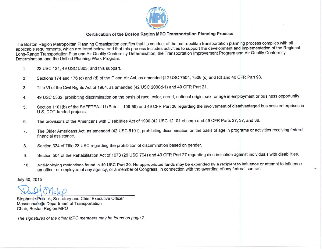
Endorsed by the Boston Region
Metropolitan Planning Organization
on July 30, 2015
Chapter Three – Project Information
Chapter Four – Tracking and Demonstrating Progress using Performance Measures
Chapter Five – Determination of Air Quality Conformity
Chapter Six – Financial Constraint
Chapter Seven – Operations and Maintenance
A Universe of Projects
B Project Information Forms and Evaluations
C Greenhouse Gas Monitoring and Evaluation
D FFY 2015 Highway Projects Status
E Transit Projects Status
F Public Comments on the Draft FFYs 2016 – 20 TIP
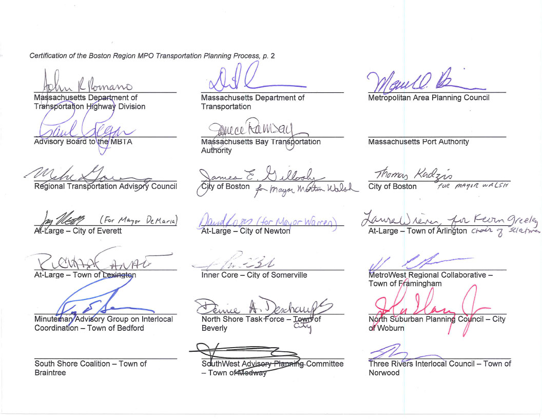
MassDOT Office of Planning and Programming
Massachusetts Bay Transportation Authority
Massachusetts Bay Transportation Authority Advisory Board
MassDOT Highway Department
Massachusetts Port Authority
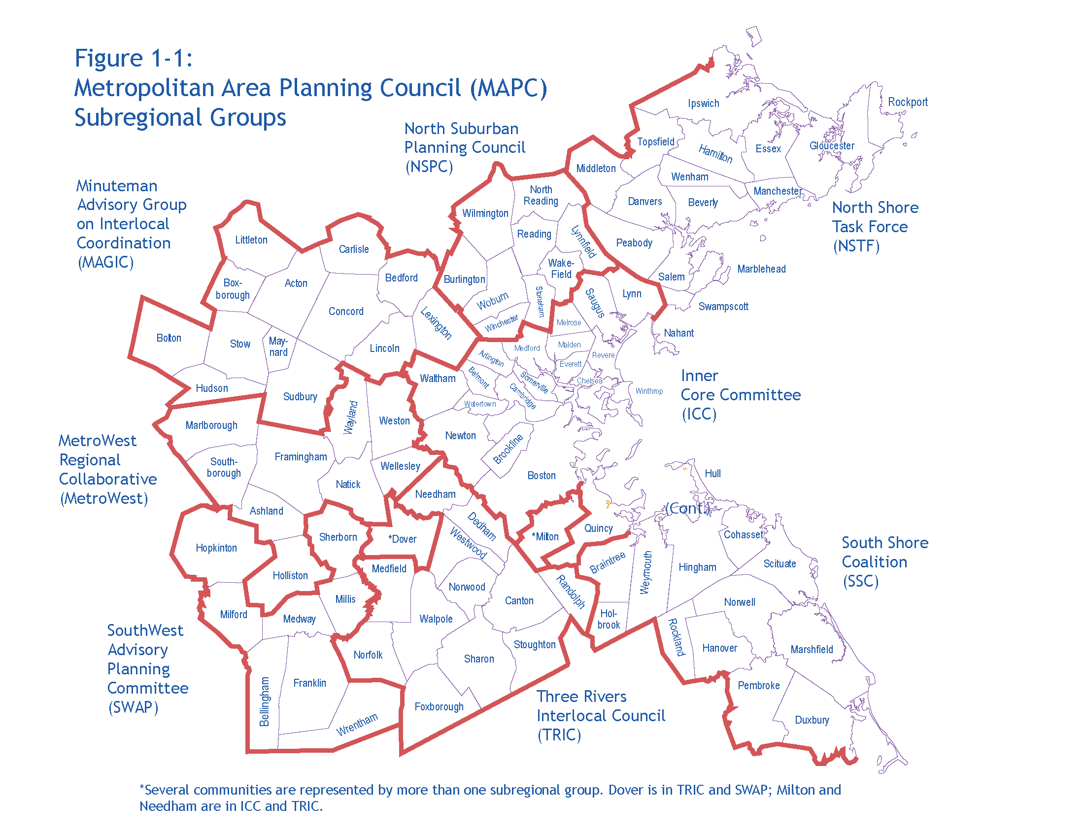
Metropolitan Area Planning Council
Regional Transportation Advisory Council
City of Boston
City of Beverly (North Shore Task Force)
City of Everett (At-Large City)
City of Newton (At-Large City)
City of Somerville (Inner Core Committee)
City of Woburn (North Suburban Planning Council)
Town of Arlington (At-Large Town)
Town of Bedford (Minuteman Advisory Group on Interlocal Coordination)
Town of Braintree (South Shore Coalition)
Town of Framingham (MetroWest Regional Collaborative)
Town of Lexington (At-Large Town)
Town of Medway (South West Advisory Planning Committee)
Town of Norwood (Three Rivers Interlocal Council)
Federal Highway Administration (nonvoting)
Federal Transit Administration (nonvoting)
The Boston Region Metropolitan Planning Organization (MPO) complies with Title VI of the Civil Rights Act of 1964, the Americans with Disabilities Act (ADA) and other federal and state nondiscrimination statutes and regulations in all programs and activities. The MPO does not discriminate on the basis of race, color, national origin, English proficiency, income, religious creed, ancestry, disability, age, gender, sexual orientation, gender identity or expression, or military service. Any person who believes herself/himself or any specific class of persons has been subjected to discrimination prohibited by Title VI, ADA, or other non-discrimination statute or regulation may, herself/himself or via a representative, file a written complaint with the MPO. A complaint must be filed no later than 180 calendar days after the date on which the person believes the discrimination occurred. A complaint form and additional information can be obtained by contacting the MPO (see below) or at www.bostonmpo.org.
Please visit www.ctps.org to view the full TIP. To request a copy of the TIP in CD or accessible formats, please contact us by any of the following means:
This document was funded in part through grants from the Federal Highway Administration and Federal Transit Administration of the U.S. Department of Transportation. Its contents do not necessarily reflect the official views or policy of the U.S. DOT.
Federal Fiscal Years 2016–20 Transportation Improvement Program
The Boston Region Metropolitan Planning Organization’s (MPO’s) five-year, nearly $2 billion transportation capital plan, the Transportation Improvement Program (TIP), is the near-term investment program for the region’s transportation system. Guided by the MPO’s visions and policies, the TIP prioritizes investments that preserve the current transportation system in a state of good repair, provide safe transportation for all modes, enhance livability, and improve mobility throughout the region. These investments fund major highway reconstruction, arterial and intersection improvements, maintenance and expansion of the public transit system, bicycle path construction, and improvements for pedestrians.
The Boston Region MPO is a 22-member board with representatives of state agencies, regional organizations, and municipalities; its jurisdiction extends from Boston north to Ipswich, south to Duxbury, and west to Interstate 495. Each year, the MPO conducts a process to decide how to spend federal transportation funds for capital projects. The Central Transportation Planning Staff (CTPS), which is the staff to the MPO, manages the TIP-development process.
MPO staff coordinate the evaluation of project requests, propose the programming of current and new projects based on anticipated funding levels, support the MPO in the development of a draft document, and facilitate a public review of the draft document before the MPO endorses the final document.
The federal fiscal years (FFYs) 2016–20 TIP consists of approximately $940 million worth of transportation investments in the Highway Program and more than $1 billion in the Transit Program. These investments reflect the MPO’s goal of targeting a majority of transportation resources to preserve and modernize the existing roadway and transit system and maintain it in a state of good repair.
This TIP devotes a more significant portion of funding for the targeted expansion of the rapid transit system and new shared-use paths than previous TIPs. In addition, a number of the infrastructure investments in this TIP address needs identified in the MPO’s Long-Range Transportation Plan (LRTP), Charting Progress to 2040, or implement recommendations from past studies and reports that were funded through the MPO’s Unified Planning Work Program.
The Transit Program of the TIP provides funding for projects and programs that address capital needs that have been given priority by the three transit agencies in the region: the Massachusetts Bay Transportation Authority (MBTA), the Cape Ann Transportation Authority (CATA), and the MetroWest Regional Transit Authority (MWRTA). The Transit Program is predominantly dedicated to achieving and maintaining a state of good repair for all assets throughout the transit system.
Over the next four fiscal years, the MBTA will invest heavily in its bus fleets.
The MBTA will also invest in the MBTA’s bridges and tunnels. Funds will also be dedicated to improving accessibility at MBTA subway stations and other light rail, commuter rail, and bus stations throughout the system, as well as the Silver Line. Transit expansion will be funded in the Highway Program as discussed below.
The Highway Program of the TIP funds priority transportation projects advanced by the Massachusetts Department of Transportation (MassDOT) and cities and towns within the 101-municipality MPO region. The program is primarily devoted to preserving and modernizing the existing roadway network through the resurfacing of highways, replacement of bridges, and reconstruction of arterial roadways.
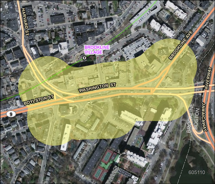
Over the next five years, more than $230 million (25 percent) of funds in the Highway Program will be used to resurface interstate and state routes, replace highway lighting and signage, and add travel lanes and shoulders to more than three miles of Route 128. Approximately $260 million (27 percent) will be spent to modernize roadways in order to balance the needs of all users—motorists, bicyclists, and pedestrians. Multimodal projects, such as the improvements to Route 9 in Brookline, will improve safety and enhance access for pedestrians, bicyclists, transit riders, and automobiles. In total, roadway modernization projects will improve nearly 50 lane miles of substandard pavement traveled by nearly 500,000 vehicles. These corridor investments will also add 24 miles of new on-road bicycle accommodations.
Nearly $260 million (27 percent) of the Highway Program will be used to address functionally obsolete and structurally deficient bridges. These improvements will benefit the more than 600,000 vehicles that cross these substandard bridges on a typical weekday.
The program also invests in the targeted expansion of transit service and bicycle and pedestrian facilities to grow the transit, bicycle, and pedestrian networks. In the draft TIP, $158 million (17 percent) of the Highway Program funds are allocated to transit to extend the Green Line beyond College Avenue to Route 16/Mystic Valley Parkway in Medford. Lastly, the MPO will invest nearly $35 million (4 percent) to extend rail trails, construct shared-use paths, and improve bicycle and pedestrian facilities around schools. A majority of these facilities will also provide direct access to MBTA stations: the Bruce Freeman Rail Trail will link to the West Concord Station, the Cochituate Rail Trail will connect to the Natick Station, and the New Fenway Multi-use Path will improve access to the Fenway Station and the Yawkey Station.
Funds programmed in the Transit Program of the TIP are allocated by the Federal Transit Administration by formula. The three regional transit authorities in the Boston Region MPO area that are recipients of these funds are the MBTA, CATA, and MWRTA. The MBTA, with its extensive transit program and infrastructure, is the recipient of the preponderance of federal transit funds in the region.
Under the federal transportation legislation, Moving Ahead for Progress in the 21st Century Act (MAP-21), funding is allocated by the following categories:
The Highway Program of the TIP was developed under the assumption that there would be $600 million of federal dollars available annually over the next five years for highway projects statewide. In Massachusetts, federal highway program funding is allocated to several main funding categories.
First, MassDOT allocates federal funding to Grant Anticipation Notes (GANs) payments. Over the four years of this TIP, approximately $245 million of the Highway Program is dedicated to GANs payments for the Accelerated Bridge Program. MassDOT matches the remaining amount of federal funding with an 80 percent (federal) and 20 percent (state) split.
Next, MassDOT allocates funding across the following funding categories:
After these needs have been satisfied, MassDOT allocates the remaining federal funding among the state’s MPOs for programming. This discretionary funding for MPOs is suballocated by formula to determine “Regional Target” amounts. MassDOT develops these targets in consultation with the Massachusetts Association of Regional Planning Agencies. Each MPO can decide how to prioritize their Regional Target funding.
In order to determine which projects to fund through the Regional Target funding process, MPO members collaborate with municipalities, state agencies, members of the public, advocacy groups, and other stakeholders. The MPO’s project selection process uses evaluation criteria to help identify and prioritize projects that advance the MPO’s goals. The criteria are based on the MPO’s visions and policies, which were adopted for its current LRTP, Paths to a Sustainable Region. These criteria closely align with the draft LRTP, Charting Progress to 2040, and MPO staff plan to update the evaluation criteria to guide future TIP investments after Charting Progress to 2040 is finalized.
The outreach process begins early in the fiscal year when MPO staff begin to brief local officials and members of the public on the upcoming year’s development process. Each November, MPO staff ask the staffs of cities and towns in the region to identify their priority projects for consideration for federal funding. MPO staff compile the project requests and relevant information into a Universe of Projects list for the MPO. The Universe of Projects list includes projects in varied stages of development, from projects in the conceptual stage to those that are fully designed and ready to be advertised for construction. MPO staff also collect data on each project in the universe so that the projects can be evaluated.
Once project updates are complete, the staff evaluates projects based on how well they address the MPO’s policies in the following categories:
This year, the staff completed evaluations for approximately 50 projects. A basic level of design is needed to provide enough information to fully evaluate a potential TIP project. In some cases, not enough information is available to fully evaluate a project across all six policy categories. The evaluation results are posted on the MPO’s website, allowing municipal officials and members of the public to view and provide feedback on the evaluation results.
MPO staff use the project information and evaluation results to prepare a First-Tier List of Projects—projects that have received high scores through the TIP evaluation process and could be made ready for advertisement within the time frame of the upcoming TIP. MPO staff then prepare a recommendation for the TIP considering the First-Tier list and other factors, such as the construction readiness of a project, the estimated project cost, community priority, geographic equity (to ensure that needs are addressed throughout the region), and consistency with the MPO’s LRTP. The staff recommendation proposes the projects to be funded with the MPO’s Regional Target funding over the next five years. This year, the MPO voted to add a fifth year to the TIP in order to align with the first time band of the LRTP.
The staff recommendation is always financially constrained. This year, there was approximately $440 million available for MPO Regional Target projects in FFYs 2016–20. In April 2015, the staff recommendation was submitted to the MPO and was discussed.
The MPO considers the evaluation results, First-Tier List of Projects, and staff recommendation when prioritizing which projects should receive Regional Target funding. In addition to prioritizing the Regional Target funding, the MPO also reviews the Statewide Infrastructure Items and Bridge Programs, as well as the capital programs for the MBTA, CATA, and MWRTA before voting to release a draft TIP for public review.
In mid-June of 2015, the MPO voted to release the draft FFYs 2016–20 TIP for a 30-day public comment period. The MPO invites members of the public, regional and local officials, and other stakeholders in the Boston region to review the proposed program during this period. In addition, several outreach sessions are held during the public comment period to solicit comments on the draft TIP.
After the comment period, the MPO reviewed all of the comments and endorsed the FFYs 2016–20 TIP on July 30, 2015. The MPO-endorsed TIP will be incorporated into the State Transportation Improvement Program (STIP), which is a compilation of TIPs from all of the MPOs in Massachusetts, and sent to the Federal Highway Administration and Federal Transit Administration to enable the document to be approved by the federal agencies by September 30, 2015 before the start of FFY 2016.
Even after the TIP has been finalized, administrative modifications and amendments often must be introduced because of changes in project status, project cost, or available revenues. This may necessitate reprogramming a project to a later funding year or programming additional funds for a project.
Notices of amendments and administrative modifications are posted on the MPO’s website. If an amendment is necessary, the Regional Transportation Advisory Council is informed, and the affected municipalities and other stakeholders are notified through the MPO’s email listserv, MPOinfo. The MPO holds a 30-day public comment period before taking action on an amendment. Administrative modifications are generally minor adjustments that usually do not warrant a public comment period.
Public input is an important aspect of the transportation-planning process. Please visitwww.bostonmpo.org for more information about the MPO, to view the full TIP, and to submit your comments. You may also want to sign up for our email news updates by contacting us at publicinformation@ctps.org.
To request a copy of the TIP in CD or accessible formats, please contact us by any of the following means:
Mail: Boston Region MPO
Certification Activities Group
10 Park Plaza, Suite 2150
Boston, MA 02116-3968
Telephone: 857.702.3700
TTY: 617.973.7089
Fax: 617.570.9192
Email: publicinformation@ctps.org
The 3C Process
Decisions about how to spend transportation funds in a metropolitan area are guided by information and ideas from a broad group of people, including elected officials, municipal planners and engineers, transportation advocates, other advocates, and other interested persons. Metropolitan planning organizations (MPOs) are the bodies responsible for providing a forum for this decision-making process. Each metropolitan area in the United States with a population of 50,000 or more has an MPO, which decides how to spend federal transportation funds for capital projects and planning studies.
In order to be eligible for federal funds, metropolitan areas are required to maintain a continuing, cooperative, and comprehensive (3C) transportation-planning process that results in plans and programs consistent with the planning objectives of the metropolitan area.1 The 3C transportation-planning process in the Boston region is the responsibility of the Boston Region MPO, which has established the following objectives for the process:
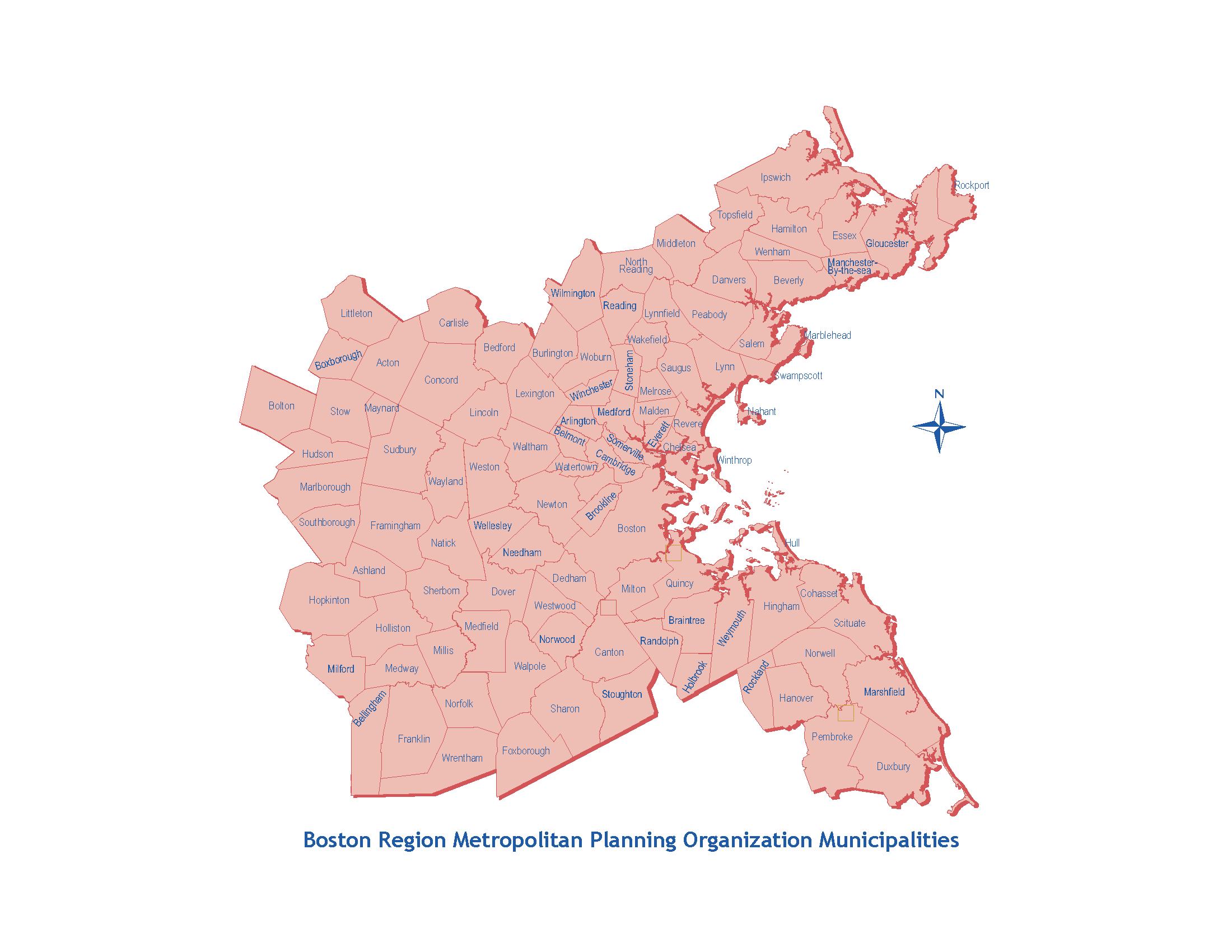
The Boston Region MPO is a 22-member board consisting of state agencies, regional organizations, and municipalities; its jurisdiction extends from Boston north to Ipswich, south to Duxbury, and west to Interstate 495. There are 101 cities and towns that make up this area (as shown in Figure 1-1).
As part of its 3C process, the Boston Region MPO annually produces the Transportation Improvement Program (TIP) and the Unified Planning Work Program (UPWP). These documents, along with the Long-Range Transportation Plan (LRTP), are required for the MPO’s process to be certified as meeting federal requirements; this certification is a prerequisite for receiving federal transportation funds.
This TIP was developed and approved by the MPO members listed below. The permanent MPO voting members are the Massachusetts Department of Transportation (MassDOT), Metropolitan Area Planning Council (MAPC), Massachusetts Bay Transportation Authority (MBTA), MBTA Advisory Board, Massachusetts Port Authority (Massport), City of Boston, and Regional Transportation Advisory Council. The elected MPO voting members and their respective seats are:
City of Beverly: North Shore Task Force
City of Everett: At-Large City
City of Newton: At-Large City
City of Somerville: Inner Core Committee
City of Woburn: North Suburban Planning Council
Town of Arlington: At-Large Town
Town of Bedford: Minuteman Advisory Group on Interlocal Coordination
Town of Braintree: South Shore Coalition
Town of Framingham: MetroWest Regional Collaborative
Town of Lexington: At-Large Town
Town of Medway: SouthWest Advisory Planning Committee
Town of Norwood: Three Rivers Interlocal Council
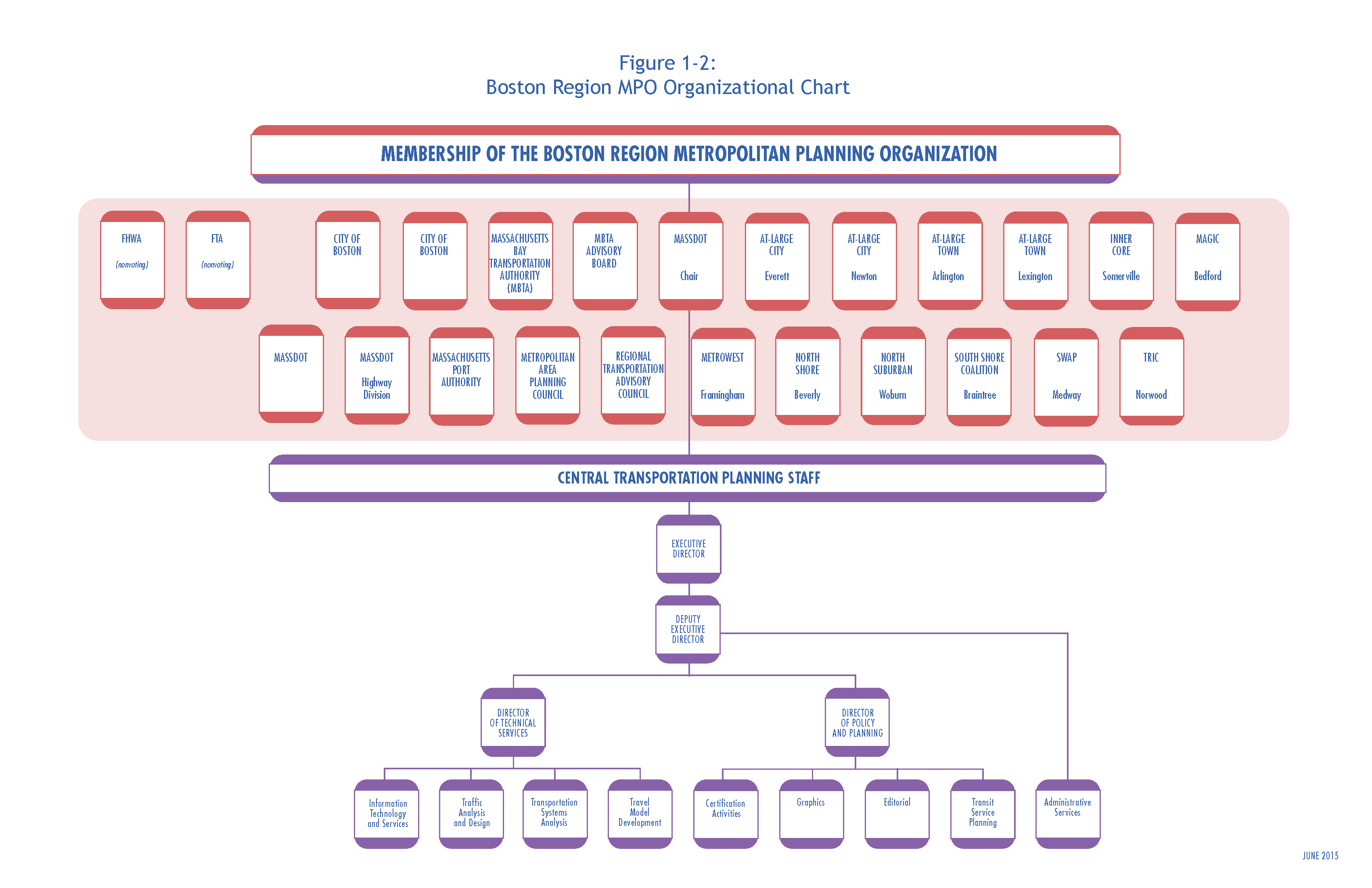
In addition, the Federal Highway Administration (FHWA) and the Federal Transit Administration (FTA) participate in the MPO as advisory (nonvoting) members. Figure 1-2 shows the organization chart of the MPO membership and the MPO’s staff, the Central Transportation Planning Staff (CTPS).
MassDOT has three seats on the MPO, including one for the Highway Division.
Two members participate in the Boston Region MPO in an advisory (nonvoting) capacity, reviewing the LRTP, the TIP, and the UPWP to ensure compliance with federal planning and programming requirements:
Two other entities assist MPO members in carrying out the responsibilities of the MPO’s 3C planning process through policy implementation, technical support, and public participation:
The following section briefly describes the three documents produced by the MPO as part of its federally required 3C process:
MAP-21 legislation requires all MPOs to carry out the 3C process. To meet this requirement, MPOs must perform the following activities:
MAP-21 legislation establishes national goals for federal highway programs, including:
MAP-21 also establishes performance-based planning as an integral part of the metropolitan planning process. Under MAP-21, states will develop performance goals, guided by the national goals cited in MAP-21, and MPOs will work with state departments of transportation (DOTs) to develop MPO performance targets. The TIP will integrate the MPO’s performance measures and link transportation-investment decisions to progress toward achieving performance goals.
Air-quality conformity determinations must be performed for capital improvement projects that receive federal funding and for those that are considered regionally significant, regardless of the funding source. These determinations must show that the MPO’s LRTP and TIP will not cause or contribute to any new air-quality violations, will not increase the frequency or severity of any existing air-quality violations in any area, and will not delay the timely attainment of the air-quality standards in any area.
Transportation control measures identified in the State Implementation Plan for the attainment of air-quality standards are federally enforceable and must be given first priority when using federal funds. Such projects include parking-freeze programs in Boston and Cambridge, statewide rideshare programs, rapid-transit and commuter-rail extension programs, park-and-ride facilities, residential parking-sticker programs, and the operation of high-occupancy-vehicle lanes.
The Boston Region MPO complies with Title VI of the Civil Rights Act of 1964, the ADA, and other federal and state nondiscrimination statutes and regulations in all of its programs and activities. The MPO does not discriminate on the basis of race, color, national origin, English proficiency, income, religious creed, ancestry, disability, age, gender, sexual orientation, gender identity or expression, or military service. The major federal requirements are discussed below.
This statute requires that no person be excluded from participation in, be denied the benefits of, or be subjected to discrimination on the basis of race, color, or national origin under any program or activity provided by an agency receiving federal financial assistance.
Executive Order 13166, dated August 11, 2000, extends Title VI protections to persons who, as a result of national origin, have limited English-language proficiency (LEP). Specifically, it calls for improved access to federally conducted and assisted programs and activities and requires MPOs to develop and implement a system by which LEP persons can meaningfully participate in the transportation-planning process.
Executive Order 12898, dated February 11, 1994, further expands upon Title VI, requiring each federal agency to achieve environmental justice by identifying and addressing any disproportionately high adverse human health or environmental effects, including interrelated social and economic effects, of its programs, policies, and activities on minority or low-income populations.
On April 15, 1997, the US Department of Transportation issued its Final Order to Address Environmental Justice in Minority Populations and Low-Income Populations. Among other provisions, this order requires programming and planning activities to:
Title III of the ADA requires all transportation projects, plans, and programs to be accessible to people with disabilities. At the MPO level, this means that public meetings must be held in accessible buildings and MPO materials must be made available in accessible formats.
This executive order, dated February 26, 2004, calls for the establishment of the Interagency Transportation Coordinating Council on Access and Mobility under the aegis of the Secretary of Transportation. This executive order reinforces both environmental justice and ADA requirements by charging the Council with developing policies and methods for improving access for people with disabilities, low-income persons, and older adults.
The Global Warming Solutions Act (GWSA) makes Massachusetts a leader in setting aggressive and enforceable greenhouse gas (GHG) reduction targets and implementing policies and initiatives to achieve these targets. In keeping with this law, the Massachusetts Executive Office of Energy and Environmental Affairs, in consultation with other state agencies and the public, developed the Massachusetts Clean Energy and Climate Plan for 2020. This implementation plan, released on December 29, 2010, establishes the following targets for overall statewide GHG emissions:
The transportation sector is the single largest contributor of GHGs, accounting for more than one-third of GHG emissions, and therefore is a major focus of the Clean Energy and Climate Plan for 2020. MassDOT’s approach to supporting implementation of the plan is presented in its GreenDOT Policy Directive, a comprehensive sustainability initiative that sets three principal objectives:
The Commonwealth’s 13 MPOs are integrally involved in helping to achieve the GreenDOT objectives and supporting the GHG reductions mandated under the GWSA. The MPOs seek to realize these objectives by prioritizing projects in the LRTP and TIP. The Boston Region MPO’s TIP project evaluation criteria are used to score projects based on GHG emissions impacts, multimodal Complete Streets accommodations, and their ability to support smart-growth development. Tracking and evaluating GHG emissions by project will enable the MPOs to identify anticipated GHG impacts of the planned and programmed projects and also to use GHG impacts as a criterion to prioritize transportation investments.
The MPO considered the degree to which a proposed TIP project would advance the goals and objectives that guided the development of its LRTP. The MPO also reviewed TIP projects within the context of the recommended projects included in the LRTP.
The MPO aims to implement the recommendations of past studies and reports of the UPWP. This information was considered by the MPO in the development of the draft TIP.
The purpose of the Congestion Management Process (CMP) is to 1) monitor and analyze the performance of facilities and services; 2) develop strategies for the management of congestion based on the results of monitoring; and 3) move these strategies into the implementation stage by providing decision makers in the region with information and recommendations for the improvement of transportation system performance. The CMP monitors roadways and park-and-ride facilities in the MPO region for safety, congestion, and mobility, and identifies “problem” locations. Projects that help address problems identified in the most recent CMP monitoring were considered for inclusion in this TIP.
In 2009, the MBTA adopted its current PMT, which is the MBTA’s long-range capital plan. The PMT was developed with extensive public involvement and was approved by the MBTA Advisory Board. The next PMT development process will begin in 2015 and identify a set of achievable investments that will help the MBTA and MassDOT advance towards a future transit system that meets our statewide mobility goals and objectives.
MetroFuture, which was developed by MAPC and adopted in 2008, is the long-range plan for land use, housing, economic development, and environmental preservation in the Boston region. It includes a vision for the region’s future and a set of strategies for achieving that future, and it was adopted as the future land-use scenario for the MPO’s LRTP, Paths to a Sustainable Region. MetroFuture’s goals, objectives, and strategies were considered in the development of this TIP.
A statewide initiative designed as a bottom-up approach to transportation planning, youMove Massachusetts (YMM) developed 10 core themes derived from a broad-based public participation process that articulated the expressed concerns, needs, and aspirations of Massachusetts residents related to their transportation network. These themes formed the basis for the YMM Interim Report (2009), and they were considered in the development of this TIP.
MassDOT’s statewide strategic multimodal plan, weMove Massachusetts (WMM) is a product of the transportation reform legislation of 2009 and the YMM civic engagement process. In May 2014, MassDOT released WMM: Planning for Performance, the Commonwealth of Massachusetts’ 2040 LRTP. WMM identifies high-level policy priorities that were considered in the development of this TIP. WMM also incorporates performance management into investment decision-making to calculate the differences in performance outcomes resulting from different funding levels available to MassDOT. In the future, MassDOT will use this scenario tool to update and refine investment priorities. The TIP builds on this data-driven method to prioritize transportation investments.
The Healthy Transportation Compact (HTC) is a major requirement of the Massachusetts landmark transportation reform legislation that took effect on November 1, 2009. It is an interagency initiative that will help ensure that the transportation decisions made by the Commonwealth balance the needs of all transportation users, expand mobility, improve public health, support a cleaner environment, and create stronger communities.
The agencies work together to achieve positive health outcomes by coordinating land use, transportation, and public health policy. HTC membership is made up of the Secretary of Transportation or designee (co-chair), the Secretary of Health and Human Services or designee (co-chair), the Secretary of Energy and Environmental Affairs or designee, the Administrator of Transportation for Highways or designee, the Administrator of Transportation for Mass Transit or designee, and the Commissioner of Public Health or designee.
The HTC also promotes improved coordination among the public and private sectors and advocacy groups, as well as transportation, land-use, and public health stakeholders. As part of the framework for the HTC, MassDOT established a Healthy Transportation Advisory Group comprised of advocates and leaders in the fields of land-use, transportation, and public health policy.
The $3 billion Patrick-Murray Accelerated Bridge Program (ABP) represents a monumental investment in Massachusetts’ bridges. This program will greatly reduce the number of structurally deficient bridges in the state system while creating thousands of construction jobs.
To complete this program, MassDOT and the DCR have relied on innovative and accelerated project development and construction techniques. As a result, projects have been completed on time, on budget, and with minimal disruption to people and commerce.
Since 2008, the number of former structurally deficient bridges has dropped from 543 to 416, a decline of more than 23 percent. As of May 1, 2015, the ABP has completed 167 bridge projects, with another 26 bridge projects in construction and an additional 6 bridge projects scheduled to start construction within the next calendar year. Over the course of the eight-year ABP program, more than 250 bridges will be replaced or repaired.
In the fall of 2012, MassDOT announced a statewide mode shift goal: to triple the share of travel in Massachusetts that uses bicycling, transit, and walking. The mode shift goal aims to foster improved quality of life by enhancing our environment and preserving the capacity of our highway network. In addition, positive public health outcomes will be achieved by providing more healthy transportation options. On September 9, 2013, MassDOT passed the Healthy Transportation Policy Directive to formalize its commitment to implementing and maintaining transportation networks that serve all mode choices. This directive will ensure that all MassDOT projects are designed and implemented in ways that would provide all customers with access to safe and comfortable walking, bicycling, and transit options.
In choosing projects to include in the TIP, the Boston Region MPO considers the degree to which a project promotes the following MPO policies that were adopted in April 2010 and are the basis for the TIP evaluation process:
Maximizing efficiency, reliability, mobility, and accessibility within our existing infrastructure while taking into account current and ongoing fiscal constraints will require following a program of strategic needs-based investments. To accomplish this, the MPO will put a priority on programs, services, and projects that will:
To make livability a hallmark of communities in the MPO region and to achieve mobility, foster sustainable communities, and expand economic opportunities and prosperity, the MPO will put a priority on programs, services, and projects that:
To improve mobility for people and freight, the MPO will put a priority on programs, services, and projects that:
To protect the environment and minimize the impacts from transportation systems, the MPO will put a priority on programs, services, and projects that:
To provide for the equitable sharing of the benefits and burdens of transportation investments among all residents of the region, the MPO will put a priority on programs, services, and projects that:
To meet targets for reducing GHG emissions, the MPO will put a priority on programs, services, and projects that:
To provide for maximum transportation safety and to support security in the region, the MPO will put a priority on programs, services, and projects that:
In the development of the LRTP, Charting Progress to 2040 (scheduled to be endorsed in July 2015), the Boston Region MPO updated its vision, goals, and objectives. These updated goals and objectives, listed on the following pages, will guide future investment decisions through the LRTP, TIP, and UPWP. Following the MPO’s endorsement of Charting Progress to 2040, MPO staff will update the TIP evaluation criteria to align future investment decisions with the new goals and objectives.
The Boston Region Metropolitan Planning Organization envisions a modern transportation system that is safe, uses new technologies, provides equitable access, excellent mobility, and varied transportation options—in support of a sustainable, healthy, livable, and economically vibrant region.
Transportation by all modes will be safe
Maintain the transportation system
Use existing facility capacity more efficiently and increase healthy transportation capacity
Create an environmentally friendly transportation system
Provide comparable transportation access and service quality among communities, regardless of income level or minority population
Ensure our transportation network provides a strong foundation for economic vitality
The TIP Process
How to allocate scarce funds while realizing the best possible transportation system is one of the most important decisions an MPO faces in planning for its region’s future. Transportation improvements form part of the solution to many critical regional, state, national, and even global problems, such as traffic congestion, air pollution, traffic fatalities and injuries, climate change, and environmental justice. Because there is not nearly enough funding available to build all of the necessary and worthy projects that would address these problems, MPOs’ investments choices must be guided by policies that help identify the most viable solutions.
Thus, each year, the Boston Region MPO conducts a TIP development process that prioritizes transportation investments and helps the MPO decide how to spend federal transportation funds for capital projects. The Central Transportation Planning Staff to the Boston Region MPO manages the annual development process for the TIP. MPO staff help evaluate project requests, propose programming of new and current projects based on anticipated funding levels, support the MPO by creating a draft TIP document, and facilitate a public review of the draft before the MPO endorses the final document.
The first step in allocating federal transportation funds is a multiyear authorization act that establishes a maximum level of federal transportation funding per federal fiscal year. Establishing this level of funding is referred to as an authorization. The most recent authorization act is Moving Ahead for Progress in the 21st Century (MAP-21), which was signed into law on July 6, 2012.
Once the authorization level has been established, the United States Department of Transportation annually allocates funding among the states, based on various federal formulas. This allocation is referred to as an apportionment. The annual apportionment rarely represents the actual amount of federal funds that are committed to a state because of federally imposed funding limitations on spending in a given fiscal year, referred to as the obligation authority.
Obligation authority may be imposed in a multiyear authorization act, in the annual appropriations act, or in both. Obligation authority is typically less than a state’s apportionment. In Massachusetts, TIPs are developed based on the estimated obligation authority.
Two of the most important distinctions between apportionment and obligation authority are: 1) apportionment is allocated on a per-program basis, while obligation authority is generally allocated as a lump sum; and 2) unused apportionment carries forward into successive federal fiscal years (FFYs), but unused obligation authority does not. Unused apportionment that is carried forward is referred to as an unobligated balance. Although a state’s unobligated balance can be used to increase the amount of federal aid programmed within a particular funding category in a given FFY, it cannot be used to increase the total amount of the state’s highway apportionment.
Federal regulations require states to “provide MPOs with estimates of Federal and State funds which the MPOs shall utilize in developing financial plans” for TIPs.3 The FFYs 2016–20 TIP was developed with the assumption that the Statewide Federal Highway Program funding would be $600 million annually for the next four years. In Massachusetts, federal highway program funding is allocated to several major funding categories. First, MassDOT allocates federal funding to repay Grant Anticipation Notes (GANs) used to fund the Accelerated Bridge Program. During the four years of this TIP, approximately $245 million of the Highway Program is dedicated to GANs payments for the Accelerated Bridge Program. MassDOT matches the remaining amount of federal funding with an 80 percent (federal) and 20 percent (state) split. Next, MassDOT allocates funding based on the following categories:
In FFY 2017, MassDOT will end funding for the Regional Major Infrastructure Program after reconstruction of the I-91 Viaduct in Springfield has been completed. These funds will be reallocated to the Regional Target program for prioritization by MPOs across the state.
After these needs have been satisfied, the remaining federal funding is allocated to the state’s MPOs for programming. This discretionary funding for MPOs is suballocated by formula to determine “regional target” amounts, which are developed in consultation with the Massachusetts Association of Regional Planning Agencies. Each MPO decides how its Regional Target funding is prioritized. During the next five years, the Boston Region MPO’s total Regional Target Program funding is approximately $440 million, an average of $88 million annually. To decide how to spend its Regional Target funding, the Boston Region MPO engages its 101 cities and towns in an annual development process.
The Federal Transit Program is allocated within the Boston Urbanized Area (UZA) by formula to the transit service operators. The formula considers passenger-miles, population density, and other factors associated with each transit provider. The three regional transit authorities (RTAs) in the Boston Region MPO area are the MBTA, MWRTA, and CATA. The MBTA, with its extensive transit program and infrastructure, is the recipient of the preponderance of federal transit funds in the region.
Many federal-aid transportation programs support transportation activities in metropolitan areas, each area having different requirements and program characteristics. Non-federal aid (state funds) for the statewide infrastructure items, the bridge program, and the regional targets is derived from various sources, including the Commonwealth’s Transportation Bond Bill. Under MAP-21, federal programs that fund projects in the FFYs 2016–20 TIP are listed in the following two tables.
TABLE 2-1
Federal Transit Administration Programs
MAP-21 Program |
Eligible Uses |
Examples |
|---|---|---|
Urbanized Area Formula Grants (Section 5307) |
Transit capital and operating assistance in urbanized areas. Under MAP-21, job access and reverse-commute activities (formerly funded under Section 5316) are now eligible for funding under Section 5307. |
Preventive Maintenance – FFYs 2016–19 |
Fixed Guideway/Bus (Section 5337)
|
Replacement, rehabilitation, and other state-of-good-repair capital projects. |
MBTA Bridge and Tunnel Program – FFYs 2016–19 |
Bus and Bus Facilities (Section 5339) |
Capital projects to replace, rehabilitate, and purchase buses and related equipment, and to construct bus-related facilities. |
MBTA Systems Upgrades Program – FFYs 2016–19 |
Enhanced Mobility of Seniors and Individuals with Disabilities (Section 5310) |
Capital expenses that support transportation to meet the special needs of older adults and persons with disabilities. Under MAP-21, New Freedom program (Section 5317) activities are now eligible under Section 5310. |
|
TABLE 2-2
Federal Highway Administration Programs
MAP-21 Program |
Eligible Uses |
Examples |
|---|---|---|
Congestion Mitigation and Air Quality Improvement (CMAQ) |
A wide range of projects in air quality nonattainment and maintenance areas for ozone, carbon monoxide, and small particulate matter, which reduce transportation-related emissions. |
Green Line Extension Project (Phase 2), College Avenue to Mystic Valley Parkway/Route 16– FFYs 2016–20 |
Highway Safety Improvement Program (HSIP) |
Implementation of infrastructure-related highway safety improvements |
Reconstruction of Route 85/ Maple Street (Marlborough) – FFY 2017 |
National Highway Performance Program (NHPP)
|
Improvements to interstate routes, major urban and rural arterials, connectors to major intermodal facilities, and the national defense network. Also includes replacing or rehabilitating any public bridge, and resurfacing, restoring, and rehabilitating routes on the Interstate Highway System. |
Route 128 Improvement Program (Needham and Wellesley) – FFYs 2016–18
|
Surface Transportation Program (STP)
|
A broad range of surface transportation capital needs, including roads; transit, sea, and airport access; and vanpool, bicycle, and pedestrian facilities. |
Reconstruction and Widening on Route 18 (Weymouth and Abington) – FFYs 2016–19 |
Transportation Alternatives Program (TAP)
|
Construction of infrastructure-related projects (for example, sidewalk, crossing, and on-road bicycle facility improvements). Under MAP-21, Safe Routes to School Program and Recreational Trails Program are now eligible under TAP. |
Veterans Memorial School (Saugus) – FFY 2016 |
High-Priority Projects (HPP) [Carried over from SAFETEA-LU] |
Specific, named projects for which funds are carried over from previous authorizations. |
Traffic Signal Improvements on Blue Hill Avenue and Warren Street (Boston) – FFY 2018 |
Discretionary Funding |
Specific projects included annual appropriations that are funded through grant programs such as the Transportation, Community, and System Preservation Program; Value Pricing Pilot Program; and Transportation Infrastructure Finance and Innovation Act Program. |
|
The MPO’s project selection process for highway discretionary (“regional target”) funding uses evaluation criteria to help identify and prioritize projects that advance the MPO’s goals. The criteria are based on the MPO’s visions and policies, which were adopted for its current Long-Range Transportation Plan, Paths to a Sustainable Region. These criteria closely align with the draft LRTP, Charting Progress to 2040, and MPO staff plan to update the evaluation criteria to guide future TIP investments after Charting Progress to 2040 is finalized.
All projects are required to show consistency with the Long-Range Transportation Plan and other statewide and regional plans.
The MPO staff evaluates each project that is considered for inclusion in the TIP based on the specific criteria that were developed by the MPO. Other criteria include project readiness and municipal support. Background information about the TIP project evaluation process is presented in Appendix B and on the MPO’s website, www.bostonmpo.org. The MPO reviews the effectiveness of this evaluation method and alters the process as appropriate.
The outreach process begins early in the federal fiscal year, when MPO staff begin to brief local officials and members of the public on the year’s development process. Each November, MPO staff asks the staffs of cities and towns in the region to identify their priority projects for consideration for federal funding. The MPO also solicits input from interested parties and members of the general public. The staff then compiles the project funding requests and relevant information into a Universe of Projects list for the MPO. The Universe of Projects list consists of all of the identified projects being advanced for possible funding; including projects in various stages of development, from the conceptual stage to the stage when a project is fully designed and ready to be advertised for construction.
New projects must be initiated by the MassDOT Highway Division before they can be considered for programming in the TIP. Details of the project initiation process and relevant documents can be found on MassDOT’s Project Review Committee’s webpage, www.mhd.state.ma.us. Municipal TIP Contacts and the MPO staff coordinate with each other to update each project´s Project Funding Application Form through the MPO´s Interactive TIP Database, www.bostonmpo.org. The form provides information on a project´s background, conditions and needs of the existing infrastructure, development status, and a project’s potential to help the region attain the MPO’s visions. More information on the Project Funding Application Forms is presented in Appendix B.
The MPO has begun to monitor the anticipated greenhouse gas (GHG) emission impacts of planned and programmed projects, in order to consider these impacts when prioritizing transportation investments. For more information on the GHG emission monitoring and evaluation, see Appendix C.
The MPO uses TIP project-evaluation criteria to develop a numeric score that indicates how well a project would help the region attain the MPO’s visions. This score can be used to guide the MPO in selecting the projects that would be most successful in this regard. The MPO’s visions include: maintain a state of good repair, focus investments on existing activity centers, improve mobility for people and freight, reduce the level GHG emissions, minimize environmental burdens from transportation facilities on low-income and minority populations, and provide safe transportation for all modes. Projects with components and outcomes that help attain the MPO’s goals receive higher scores.
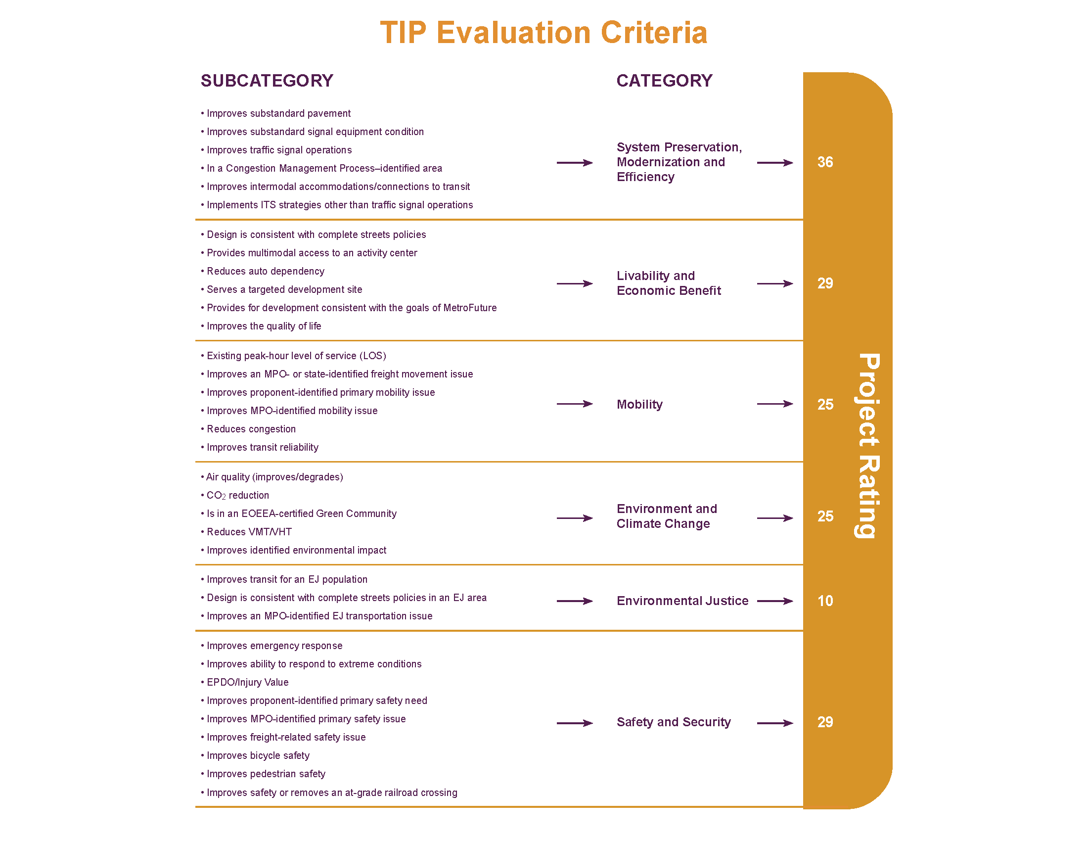
The project evaluation criteria consist of 35 questions across six policy categories. A figure that illustrates the TIP evaluation criteria (on the following page) provides an overview of the policy categories, their point values, and the criteria measures.
The MPO staff requires a functional design report (FDR) to conduct a complete evaluation (see MassDOT’s Project Development and Design Guide for information about what is included in an FDR). If not enough information is available, a project cannot be fully evaluated across all categories.
The summary of evaluation results for projects being considered for the federal fiscal years (FFYs) 2016–20 TIP is available in Table A-1, Appendix A. The table contains the total project rating for each project. For more details about the evaluation criteria used to score projects, see Appendix B.
The MPO staff used evaluations and project readiness information to prepare a first-tier list of projects. This is a list of the projects with the highest ratings that could be made ready for advertising within the TIP’s time horizon (the next four federal fiscal years). The staff relies on the MassDOT Highway Division to provide information about what year a project would be ready for advertising. In developing its recommendations for the draft TIP, MPO staff strongly considered the first-tier list of projects. The MPO staff also factored in projects that are listed in the LRTP, considered geographic equity to help ensure that the list of projects addresses needs throughout the region, and accounted for costs to comply with the fiscal constraint requirement.
The project selection criteria for the bridge program are based on MassDOT’s continuous, ongoing prioritization process. The underlying basis of this prioritization is the condition of the bridges, based largely on information gathered through the Bridge Inspection Management System.
The project selection process for the statewide infrastructure items involves coordination between the MassDOT divisions to review and prioritize projects that advance important statewide policy goals for improving mobility, protecting the environment, promoting economic growth, and improving public health and quality of life. Other prioritization factors include project readiness and consistency with MassDOT’s GreenDOT sustainability policy, the Bay State Greenway Priority 100, and the Safe Routes to School Program.
The process of selecting transit projects for the TIP draws primarily from the MBTA Capital Investment Program (CIP). The CIP is a rolling five-year plan that outlines the transit system´s infrastructure needs and planned investments within that short-range time frame. The MBTA updates the CIP annually. Prioritization of projects for inclusion in the CIP is based on their impacts on the following, as defined in the MBTA’s enabling legislation: effectiveness of the commonwealth’s transportation system; service quality; the environment, health, and safety; the state of good repair of MBTA infrastructure; and the MBTA’s operating costs and debt service.
Projects that receive the highest priority are those with the greatest benefit and the least cost, as prioritized by the following criteria:
The transit element of the TIP also includes the federal-aid programs of the other two transit authorities in the region, the Cape Ann Transportation Authority (CATA) and MetroWest Regional Transit Authority (MWRTA). CATA and MWRTA coordinate with the MassDOT Rail and Transit Division to develop their capital programs.
The MPO considers the evaluation results, first-tier list of projects, and staff recommendation in prioritizing projects for regional target funding. They also consider public input, regional importance, and other factors in developing the draft TIP. In addition to prioritizing the regional target funding, the MPO reviews statewide infrastructure items, the bridge program, and the capital programs for the MBTA, CATA, and MWRTA, before voting to release a draft TIP for public review.
In early-June 2015, the MPO voted to release the draft FFYs 2016–20 TIP for a 30-day public review and comment period. The MPO invites members of the public, regional and local officials, and other stakeholders in the Boston region to review the proposed program. Several TIP outreach sessions are held during the public comment period to solicit comments on the draft TIP; summaries of these are listed in Appendix F.
After the comment period, the MPO reviewed all of the comments it received and endorsed the FFYs 2016–20 TIP on July 30, 2015. The MPO-endorsed TIP will be incorporated into the State Transportation Improvement Program (STIP) and sent to the Federal Highway Administration and Federal Transit Administration so that the document may be approved by the federal agencies by September 30, 2015 before the start of FFY 2016.
The TIP is a dynamic program that is amended and adjusted throughout the year. Administrative modifications and amendments often must be introduced because of changes in project status, project cost, or available revenues.
Consistent with federal guidelines, if a project is valued at $5 million or less, the threshold for defining an amendment is a change of $500,000 or more. The threshold for projects valued at greater than $5 million is 10 percent or more of the project value. Changes that are less than these thresholds may be considered administrative modifications. The MPO acts on administrative modifications, and, although a public review period is not required, one may be provided at the MPO’s discretion.
Affected municipalities and constituencies are notified of pending amendments. Legal notices of amendments are placed in the region’s major newspaper, in its most widely read minority newspaper and Spanish-language newspaper, and on the MPO’s website, www.bostonmpo.org. In addition, a notice of a pending amendment is distributed to the MPO’s email contact list, MPOinfo, and, along with the actual amendment, is posted on the MPO’s website. These notices include information on the 30-day public comment period that precedes MPO action on an amendment. The Regional Transportation Advisory Council is notified and briefed during this period and provides comments to the MPO. Municipal representatives and members of the public may also submit written or oral testimony at the MPO meetings at which amendments are discussed.
Because the print version of the TIP is prepared prior to the start of each federal fiscal year, it may not reflect all of the changes to the program and projects that occur during the course of the year. The MPO’s website is the best place to find current information about the TIP.
All changes to the draft TIP that have been approved by the MPO, and changes to the endorsed TIP, such as amendments and modifications, that have been approved by the MPO, are available on the TIP webpage on the MPO’s website, www.bostonmpo.org. Comments or questions about the draft materials may be submitted directly through the website, voiced at MPO meetings, or via US mail.
Project Information
This chapter begins with tables listing, by year, the projects and programs funded in FFYs 2016–20.
Following the tables, information on projects and programs funded in the Highway and Transit Programs is presented. Projects funded under the Highway Program are listed by municipality, while programs funded under the Transit Program are listed by transit agency.
Project-tracking system have no number. Transit projects are identified by regional transit agency.
Municipality(ies): The municipality (or municipalities) in which a project is located.
Project Name: The location or name of the project.
Project Type: The category of the project (e.g., Major Highway, Arterial and Intersection, or Bicycle and Pedestrian).
Air Quality Status: The air quality status of the project in the MPO’s regional travel demand model.
CO2 Impact: The quantified or assumed annual tons of carbon dioxide reduced by the project.
See Appendix C for more details on greenhouse gas (GHG) emission monitoring and evaluation.
Evaluation Rating: The number of points scored by the project based on the evaluation criteria, if it has been evaluated.
MPO/CTPS Study: Past UPWP-funded studies or reports conducted within the project area.
LRTP Status: The time band that the project is listed in the Long-Range Transportation Plan, if applicable.
Project Length: The length of the project in miles.
Project Description: The description of the project, if available.
Year: The programming year(s) of the project.
Funding Program: The funding program(s) of the project. See Chapter 2 for more details on funding programs.
Total Funding Programmed: The total funding programmed for the project based on the year of expenditure.
Information regarding TIP projects changes periodically. For more information on all projects please visit the Interactive TIP Database at www.bostonmpo.org.
Transit Agency: Regional transit agency that is the proponent of the project.
Program/Project Name: The description of the program or project.
Air Quality Status: The air quality status of the project in the MPO’s regional travel demand model.
CO2 Impact: The quantified or assumed annual tons of carbon dioxide reduced by the project.
See Appendix C for more details on greenhouse gas (GHG) emission monitoring and evaluation.
Project Description: The description of the program or project, if available.
Year: The programming year(s) of the program or project.
Funding Program: The funding program(s) of the project. See Chapter 2 for more details on funding programs.
Total Funding Programmed: The total funding programmed for the program or project based on the year of expenditure.
TABLE 3-1
Highway Funding
| MassDOT Project Description▼ | MassDOT Project ID ▼ | Year | Funding Source ▼ | Total Programmed Funds ▼ | Federal Funds ▼ | Non-Federal Funds ▼ | Additional Information ▼ | TIP Document |
| ARLINGTON- BELMONT- HIGHWAY LIGHTING REPAIR & MAINTENANCE ON ROUTE 2 | 606381 | 2018 | STP | $5,750,000 | $4,600,000 | $1,150,000 | AC Year 1 of 2; Total Cost = $9,450,000 | FFYS 2016-20 |
| ARLINGTON- BELMONT- HIGHWAY LIGHTING REPAIR & MAINTENANCE ON ROUTE 2 | 606381 | 2019 | STP | $3,700,000 | $2,960,000 | $740,000 | AC Year 2 of 2; Total Cost = $9,450,000 | FFYS 2016-20 |
| DISTRICT 6- HIGHWAY LIGHTING SYSTEM REPLACEMENT ON I-93, FROM SOUTHAMPTON STREET TO NEPONSET AVENUE IN BOSTON | 605733 | 2016 | STP | $2,500,000 | $2,000,000 | $500,000 | AC Year 1 of 3; Total Cost = $8,250,000 | FFYS 2016-20 |
| DISTRICT 6- HIGHWAY LIGHTING SYSTEM REPLACEMENT ON I-93, FROM SOUTHAMPTON STREET TO NEPONSET AVENUE IN BOSTON | 605733 | 2017 | STP | $4,500,000 | $3,600,000 | $900,000 | AC Year 2 of 3; Total Cost = $8,250,000 | FFYS 2016-20 |
| DISTRICT 6- HIGHWAY LIGHTING SYSTEM REPLACEMENT ON I-93, FROM SOUTHAMPTON STREET TO NEPONSET AVENUE IN BOSTON | 605733 | 2018 | STP | $1,250,000 | $1,000,000 | $250,000 | AC Year 3 of 3; Total Cost = $8,250,000 | FFYS 2016-20 |
| MARLBORO RESURFACING AND RELATED WORK ON ROUTE 20 | 608221 | 2019 | NHPP | $6,126,938 | $4,901,550 | $1,225,388 | FFYS 2016-20 | |
| MEDFORD- STONEHAM- WOBURN- READING- HIGHWAY LIGHTING REHABILITATION ON I-93 (PHASE II) | 603917 | 2016 | STP | $15,000,000 | $12,000,000 | $3,000,000 | AC Year 1 of 2; Total Cost = $17,500,000 | FFYS 2016-20 |
| MEDFORD- STONEHAM- WOBURN- READING- HIGHWAY LIGHTING REHABILITATION ON I-93 (PHASE II) | 603917 | 2017 | STP | $2,500,000 | $2,000,000 | $500,000 | AC Year 2 of 2; Total Cost = $17,500,000 | FFYS 2016-20 |
| ACTON- CONCORD- BRUCE FREEMAN RAIL TRAIL CONSTRUCTION (PHASE II-B) | 606223 | 2018 | CMAQ | $6,230,016 | $4,984,013 | $1,246,003 | FFYS 2016-20 | |
| ACTON- INTERSECTION & SIGNAL IMPROVEMENTS ON SR 2 & SR 111 (MASSACHUSETTS AVENUE) AT PIPER ROAD & TAYLOR ROAD | 607748 | 2018 | HSIP | $1,500,000 | $1,350,000 | $150,000 | FFYS 2016-20 | |
| ASHLAND- RECONSTRUCTION ON ROUTE 126 (POND STREET), FROM THE FRAMINGHAM T.L. TO THE HOLLISTON T.L. | 604123 | 2020 | STP | $10,983,686 | $8,786,949 | $2,196,737 | STP+CMAQ+TAP Total Cost = $15,532,405 | FFYS 2016-20 |
| ASHLAND- RECONSTRUCTION ON ROUTE 126 (POND STREET), FROM THE FRAMINGHAM T.L. TO THE HOLLISTON T.L. | 604123 | 2020 | CMAQ | $2,000,000 | $1,600,000 | $400,000 | STP+CMAQ+TAP Total Cost = $15,532,405 | FFYS 2016-20 |
| ASHLAND- RECONSTRUCTION ON ROUTE 126 (POND STREET), FROM THE FRAMINGHAM T.L. TO THE HOLLISTON T.L. | 604123 | 2020 | TAP | $2,548,719 | $2,038,975 | $509,744 | STP+CMAQ+TAP Total Cost = $15,532,405 | FFYS 2016-20 |
| BEDFORD - SAFE ROUTES TO SCHOOL (JOHN GLENN MIDDLE) | 608000 | 2016 | TAP | $780,000 | $624,000 | $156,000 | FFYS 2016-20 | |
| BEDFORD- BILLERICA- BURLINGTON- MIDDLESEX TURNPIKE IMPROVEMENTS, FROM CROSBY DRIVE NORTH TO MANNING ROAD, INCLUDES RECONSTRUCTION OF B-04-006 (PHASE III) | 29492 | 2017 | STP | $6,604,906 | $5,283,925 | $1,320,981 | AC Yr 2 of 2; STP+Northern Middlesex Council of Governments contribution ($1,000,000) Total Cost = $29,296,348 | FFYS 2016-20 |
| BEDFORD- BILLERICA- BURLINGTON- MIDDLESEX TURNPIKE IMPROVEMENTS, FROM CROSBY DRIVE NORTH TO MANNING ROAD, INCLUDES RECONSTRUCTION OF B-04-006 (PHASE III) | 29492 | 2016 | STP | $21,691,442 | $17,353,154 | $4,338,288 | AC Yr 1 of 2; STP+Northern Middlesex Council of Governments contribution ($1,000,000) Total Cost = $29,296,348 | FFYS 2016-20 |
| BEDFORD- BILLERICA- BURLINGTON- MIDDLESEX TURNPIKE IMPROVEMENTS, FROM CROSBY DRIVE NORTH TO MANNING ROAD, INCLUDES RECONSTRUCTION OF B-04-006 (PHASE III) | 29492 | 2016 | OTHER | $1,000,000 | $800,000 | $200,000 | AC Yr 2 of 2; STP+Northern Middlesex Council of Governments contribution ($1,000,000) Total Cost = $29,296,348 | FFYS 2016-20 |
| BOSTON - TRAFFIC SIGNAL IMPROVEMENTS AT 10 LOCATIONS | 606117 | 2016 | CMAQ | $1,000,000 | $800,000 | $200,000 | CMAQ+STP Total Cost = $4,654,920 | FFYS 2016-20 |
| BOSTON - TRAFFIC SIGNAL IMPROVEMENTS AT 10 LOCATIONS | 606117 | 2016 | STP | $3,654,920 | $2,923,936 | $730,984 | CMAQ+STP Total Cost = $4,654,920 | FFYS 2016-20 |
| BOSTON- BRIDGE REHABILITATION, B-16-016, NORTH WASHINGTON STREET OVER THE CHARLES RIVER | 604173 | 2017 | NHPP |
$12,984,000 | $10,387,200 | $2,596,800 | AC Yr 1 of 4; Total Cost = $117,208,000 | FFYS 2016-20 |
| BOSTON- BRIDGE REHABILITATION, B-16-016, NORTH WASHINGTON STREET OVER THE CHARLES RIVER | 604173 | 2018 | NHPP |
$36,000,000 | $28,800,000 | $7,200,000 | AC Yr 2 of 4; Total Cost = $112,700,000 | FFYS 2016-20 |
| BOSTON- BRIDGE REHABILITATION, B-16-016, NORTH WASHINGTON STREET OVER THE CHARLES RIVER | 604173 | 2019 | NHPP |
$34,504,000 | $27,603,200 | $6,900,800 | AC Yr 3 of 4; Total Cost = $112,700,000 | FFYS 2016-20 |
| BOSTON- BRIDGE REHABILITATION, B-16-237, MASSACHUSETTS AVENUE (ROUTE 2A) OVER COMMONWEALTH AVENUE | 600867 | 2016 | NHPP |
$9,074,000 | $7,259,200 | $1,814,800 | AC Yr 1 of 2; Total Cost = $16,183,795 | FFYS 2016-20 |
| BOSTON- BRIDGE REPLACEMENT, B-16-237, MASSACHUSETTS AVENUE (ROUTE 2A) OVER COMMONWEALTH AVENUE | 600867 | 2017 | NHPP |
$7,109,795 | $5,687,836 | $1,421,959 | AC Yr 2 of 2; Total Cost = $16,183,795 | FFYS 2016-20 |
| BOSTON- BROOKLINE- MULTI-USE PATH CONSTRUCTION ON NEW FENWAY | 607888 | 2019 | CMAQ | $1,915,213 | $1,532,170 | $383,043 | FFYS 2016-20 | |
| BOSTON- IMPROVEMENTS ON BOYLSTON STREET, FROM INTERSECTION OF BROOKLINE AVENUE & PARK DRIVE TO IPSWICH STREET | 606453 | 2019 | STP | $3,000,000 | $2,400,000 | $600,000 | STP+CMAQ+TAP Total Cost = $7,373,484 | FFYS 2016-20 |
| BOSTON- IMPROVEMENTS ON BOYLSTON STREET, FROM INTERSECTION OF BROOKLINE AVENUE & PARK DRIVE TO IPSWICH STREET | 606453 | 2019 | CMAQ | $1,824,765 | $1,459,812 | $364,953 | STP+CMAQ+TAP Total Cost = $7,373,484 | FFYS 2016-20 |
| BOSTON- IMPROVEMENTS ON BOYLSTON STREET, FROM INTERSECTION OF BROOKLINE AVENUE & PARK DRIVE TO IPSWICH STREET | 606453 | 2019 | TAP | $2,548,719 | $2,038,975 | $509,744 | STP+CMAQ+TAP Total Cost = $7,373,484 | FFYS 2016-20 |
| BOSTON- INTERSECTION & SIGNAL IMPROVEMENTS AT THE VFW PARKWAY & SPRING STREET | 607759 | 2019 | HSIP | $550,000 | $495,000 | $55,000 | FFYS 2016-20 | |
| BOSTON- RECONSTRUCTION OF MELNEA CASS BOULEVARD | 605789 | 2018 | HPP (2005) | $2,429,730 | $1,943,784 | $485,946 | Construction; HPP 756 (MA126); SAFETEA-LU Earmark (HPP 756)+ SAFETEA-LU Earmark (HPP 4284) =Total Cost $7,437,105 | FFYS 2016-20 |
| BOSTON- RECONSTRUCTION OF MELNEA CASS BOULEVARD | 605789 | 2018 | HPP (2005) | $5,007,375 | $4,005,900 | $1,001,475 | Construction; HPP 4284 (MA203); SAFETEA-LU Earmark (HPP 756)+ SAFETEA-LU Earmark (HPP 4284) =Total Cost $7,437,105 | FFYS 2016-20 |
| BOSTON- RECONSTRUCTION OF RUTHERFORD AVENUE, FROM CITY SQUARE TO SULLIVAN SQUARE | 606226 | 2020 | STP | $7,000,000 | $5,600,000 | $1,400,000 | FFYS 2016-20 | |
| BOSTON- TRAFFIC SIGNAL IMPROVEMENTS ON BLUE HILL AVENUE AND WARREN STREET | 606134 | 2018 | HPP (2005) | $2,377,900 | $1,902,320 | $475,580 | Construction; HPP 2129 (MA155) | FFYS 2016-20 |
| BRAINTREE- BRIDGE REHABILITATION, B-21-060 AND B-21-061, ST 3 (SB) AND ST 3 (nb) OVER RAMP C (QUINCY ADAMS) | 607685 | 2016 | NHPP |
$11,908,000 | $9,526,400 | $2,381,600 | FFYS 2016-20 | |
| BROOKLINE- INTERSECTION & SIGNAL IMPROVEMENTS @ ROUTE 9 & VILLAGE SQUARE (GATEWAY EAST) | 605110 | 2017 | CMAQ | $471,811 | $377,449 | $94,362 | STP+TAP+CMAQ+Private Sector Contribution ($1,000,000) Total Cost = $5,818,649 | FFYS 2016-20 |
| BROOKLINE- INTERSECTION & SIGNAL IMPROVEMENTS @ ROUTE 9 & VILLAGE SQUARE (GATEWAY EAST) | 605110 | 2017 | TAP | $2,346,838 | $1,877,470 | $469,368 | STP+TAP+CMAQ+Private Sector Contribution ($1,000,000) Total Cost = $5,818,649 | FFYS 2016-20 |
| BROOKLINE- INTERSECTION & SIGNAL IMPROVEMENTS @ ROUTE 9 & VILLAGE SQUARE (GATEWAY EAST) | 605110 | 2017 | STP | $2,000,000 | $1,600,000 | $400,000 | STP+TAP+CMAQ+Private Sector Contribution ($1,000,000) Total Cost = $5,818,649 | FFYS 2016-20 |
| BROOKLINE- PEDESTRIAN BRIDGE REHABILITATION, B-27-016, OVER MBTA OFF CARLTON STREET | 606316 | 2016 | CMAQ | $2,846,700 | $2,277,360 | $569,340 | FFYS 2016-20 | |
| CHELSEA TO DANVERS - GUIDE AND TRAFFIC SIGN REPLACEMENT ON A SECTION OF US ROUTE 1 | 608206 | 2019 | HSIP | $5,900,000 | $5,310,000 | $590,000 | FFYS 2016-20 | |
| COHASSET- SUPERSTRUCTURE REPLACEMENT & SUBSTRUCTURE REHABILITATION, C-17-002, ATLANTIC AVENUE OVER LITTLE HARBOR INLET | 607345 | 2016 | STP-BR-OFF | $4,336,600 | $3,469,280 | $867,320 | FFYS 2016-20 | |
| CONCORD - RESURFACING AND RELATED WORK ON ROUTE 2 | 608220 | 2018 | NHPP | $1,784,160 | $1,427,328 | $356,832 | FFYS 2016-20 | |
| CONCORD- BRUCE FREEMAN RAIL TRAIL CONSTRUCTION, FROM COMMONWEALTH AVENUE TO POWDER MILL ROAD, INCLUDES 2 RAILROAD BRIDGES & 1 CULVERT (PHASE II-C) | 605189 | 2016 | CMAQ | $5,532,584 | $4,426,067 | $1,106,517 | FFYS 2016-20 | |
| DANVERS - BRIDGE REPLACEMENT, D-03-018, ROUTE 128 OVER WATERS RIVER | 607954 | 2017 | NHPP |
$10,513,973 | $8,411,178 | $2,102,795 | FFYS 2016-20 | |
| DEDHAM - RESURFACING AND RELATED WORK ON ROUTE 109 | 605608 | 2018 | NHPP | $2,523,312 | $2,018,650 | $504,662 | NHSPP+Stormwater Total Cost = $2,739,312 | FFYS 2016-20 |
| DEDHAM - RESURFACING AND RELATED WORK ON ROUTE 109 | 605608 | 2018 | STP-TE | $216,000 | $172,800 | $43,200 | NHSPP+Stormwater Total Cost = $2,739,312 | FFYS 2016-20 |
| EVERETT - SAFE ROUTES TO SCHOOL (MADELAINE ENGLISH) | 607998 | 2016 | TAP | $602,608 | $482,086 | $120,522 | FFYS 2016-20 | |
| EVERETT- RECONSTRUCTION OF FERRY STREET, SOUTH FERRY STREET AND A PORTION OF ELM STREET | 607652 | 2019 | STP | $5,244,124 | $4,195,299 | $1,048,825 | STP+HSIP Total Cost = $7,244,124 | FFYS 2016-20 |
| EVERETT- RECONSTRUCTION OF FERRY STREET, SOUTH FERRY STREET AND A PORTION OF ELM STREET | 607652 | 2019 | HSIP | $2,000,000 | $1,600,000 | $400,000 | STP+HSIP Total Cost = $7,244,124 | FFYS 2016-20 |
| FAIRMOUNT IMPROVEMENTS | 1568 | 2016 | NFA | $447,000 | $- | $447,000 | FFYS 2016-20 | |
| FAIRMOUNT IMPROVEMENTS | 1568 | 2017 | NFA | $11,574,800 | $- | $11,574,800 | FFYS 2016-20 | |
| FOXBOROUGH-PLAINVILLE-WRENTHAM-FRANKLIN- INTERSTAE MAINTENANCE AND RELATED WORK ON I-495 | 608210 | 2019 | NHPP | $29,392,384 | $26,453,146 | $2,939,238 | FFYS 2016-20 | |
| FOXBOROUGH-PLAINVILLE-WRENTHAM-INTERSTATE MAINTENANCE AND RELATED WORK ON I-495 | 606176 | 2016 | NHPP | $1,604,800 | $1,444,320 | $160,480 | IM+Stormwater Total Cost = $3,344,800 | FFYS 2016-20 |
| FOXBOROUGH-PLAINVILLE-WRENTHAM-INTERSTATE MAINTENANCE AND RELATED WORK ON I-495 | 606176 | 2016 | STP-TE | $1,740,000 | $1,392,000 | $348,000 | IM+Stormwater Total Cost = $3,344,800 | FFYS 2016-20 |
| FRAMINGHAM- NATICK- COCHITUATE RAIL TRAIL CONSTRUCTION INCLUDING PEDESTRIAN BRIDGE, N-03-014, OVER ROUTE 9 & BRIDGE OVER ROUTE 30 | 607732 | 2018 | CMAQ | $5,859,926 | $4,687,941 | $1,171,985 | FFYS 2016-20 | |
| GREEN LINE EXTENSION PROJECT (PHASE 2), COLLEGE AVENUE TO MYSTIC VALLEY PARKWAY/ROUTE 16 | 1569 | 2016 | CMAQ | $8,100,000 | $6,480,000 | $1,620,000 | Yr 1 of 6; CMAQ+STP Total Cost = $190,100,000 ($158,000,000 programmed within FFYs 2016-20 TIP) | FFYS 2016-20 |
| GREEN LINE EXTENSION PROJECT (PHASE 2), COLLEGE AVENUE TO MYSTIC VALLEY PARKWAY/ROUTE 16 | 1569 | 2017 | CMAQ | $13,427,220 | $10,741,776 | $2,685,444 | Yr 2 of 6; CMAQ+STP Total Cost = $190,100,000 ($158,000,000 programmed within FFYs 2016-20 TIP) | FFYS 2016-20 |
| GREEN LINE EXTENSION PROJECT (PHASE 2), COLLEGE AVENUE TO MYSTIC VALLEY PARKWAY/ROUTE 16 | 1569 | 2017 | STP | $16,472,780 | $13,178,224 | $3,294,556 | Yr 2 of 6; CMAQ+STP Total Cost = $190,100,000 ($158,000,000 programmed within FFYs 2016-20 TIP) | FFYS 2016-20 |
| GREEN LINE EXTENSION PROJECT (PHASE 2), COLLEGE AVENUE TO MYSTIC VALLEY PARKWAY/ROUTE 16 | 1569 | 2018 | CMAQ | $13,427,220 | $10,741,776 | $2,685,444 | Yr 3 of 6; CMAQ+STP Total Cost = $190,100,000 ($158,000,000 programmed within FFYs 2016-20 TIP) | FFYS 2016-20 |
| GREEN LINE EXTENSION PROJECT (PHASE 2), COLLEGE AVENUE TO MYSTIC VALLEY PARKWAY/ROUTE 16 | 1569 | 2018 | STP | $26,572,780 | $21,258,224 | $5,314,556 | Yr 3 of 6; CMAQ+STP Total Cost = $190,100,000 ($158,000,000 programmed within FFYs 2016-20 TIP) | FFYS 2016-20 |
| GREEN LINE EXTENSION PROJECT (PHASE 2), COLLEGE AVENUE TO MYSTIC VALLEY PARKWAY/ROUTE 16 | 1569 | 2019 | CMAQ | $13,427,220 | $10,741,776 | $2,685,444 | Yr 4 of 6; CMAQ+STP Total Cost = $190,100,000 ($158,000,000 programmed within FFYs 2016-20 TIP) | FFYS 2016-20 |
| GREEN LINE EXTENSION PROJECT (PHASE 2), COLLEGE AVENUE TO MYSTIC VALLEY PARKWAY/ROUTE 16 | 1569 | 2019 | STP | $26,572,780 | $21,258,224 | $5,314,556 | Yr 4 of 6; CMAQ+STP Total Cost = $190,100,000 ($158,000,000 programmed within FFYs 2016-20 TIP) | FFYS 2016-20 |
| GREEN LINE EXTENSION PROJECT (PHASE 2), COLLEGE AVENUE TO MYSTIC VALLEY PARKWAY/ROUTE 16 | 1569 | 2020 | CMAQ | $13,427,220 | $10,741,776 | $2,685,444 | Yr 5 of 6; CMAQ+STP Total Cost = $190,100,000 ($158,000,000 programmed within FFYs 2016-20 TIP) | FFYS 2016-20 |
| GREEN LINE EXTENSION PROJECT (PHASE 2), COLLEGE AVENUE TO MYSTIC VALLEY PARKWAY/ROUTE 16 | 1569 | 2020 | STP | $26,572,780 | $21,258,224 | $5,314,556 | Yr 5 of 6; CMAQ+STP Total Cost = $190,100,000 ($158,000,000 programmed within FFYs 2016-20 TIP) | FFYS 2016-20 |
| GREEN LINE EXTENSION PROJECT- EXTENSION TO COLLEGE AVENUE WITH THE UNION SQUARE SPUR | 1570 | 2016 | NFA | $367,838,000 | $150,000,000 | $217,838,000 | FFYS 2016-20 | |
| GREEN LINE EXTENSION PROJECT- EXTENSION TO COLLEGE AVENUE WITH THE UNION SQUARE SPUR | 1570 | 2017 | NFA | $380,670,000 | $150,000,000 | $230,670,000 | FFYS 2016-20 | |
| GREEN LINE EXTENSION PROJECT- EXTENSION TO COLLEGE AVENUE WITH THE UNION SQUARE SPUR | 1570 | 2018 | NFA | $345,558,000 | $150,000,000 | $195,558,000 | FFYS 2016-20 | |
| GREEN LINE EXTENSION PROJECT- EXTENSION TO COLLEGE AVENUE WITH THE UNION SQUARE SPUR | 1570 | 2019 | NFA | $176,196,000 | $150,000,000 | $26,196,000 | FFYS 2016-20 | |
| HANOVER- NORWELL- SUPERSTRUCTURE REPLACEMENT, H-06-010, ST 3 OVER ST 123 (WEBSTER STREET) & N-24-003, ST 3 OVER ST 123 (HIGH STREET) | 606553 | 2016 | NHPP |
$29,000,000 | $23,200,000 | $5,800,000 | AC Yr 1 of 2: Total Cost =$41,955,600 | FFYS 2016-20 |
| HANOVER- NORWELL- SUPERSTRUCTURE REPLACEMENT, H-06-010, ST 3 OVER ST 123 (WEBSTER STREET) & N-24-003, ST 3 OVER ST 123 (HIGH STREET) | 606553 | 2017 | NHPP |
$12,955,600 | $10,364,480 | $2,591,120 | AC Yr 2 of 2; Total Cost = $41,955,600 | FFYS 2016-20 |
| HINGHAM - BROCKTON - STORMWATER IMPROVEMENTS ALONG ROUTE 3A/ROUTE 28 | 608134 | 2016 | STP-TE | $479,100 | $383,280 | $95,820 | FFYS 2016-20 | |
| HINGHAM- INTERSECTION IMPROVEMENTS AT DERBY STREET, WHITING STREET (ROUTE 53) AND GARDNER STREET | 600518 | 2018 | HSIP | $611,547 | $550,392 | $61,155 | STP+HSIP Total Cost = $3,057,735 | FFYS 2016-20 |
| HINGHAM- INTERSECTION IMPROVEMENTS AT DERBY STREET, WHITING STREET (ROUTE 53) AND GARDNER STREET | 600518 | 2018 | STP | $2,446,188 | $1,956,950 | $489,238 | STP+HSIP Total Cost = $3,057,735 | FFYS 2016-20 |
| HINGHAM- RECONSTRUCTION & RELATED WORK ON DERBY STREET, FROM POND PARK ROAD TO CUSHING STREET | 607309 | 2017 | CMAQ | $3,195,430 | $2,556,344 | $639,086 | HSIP+CMAQ Total Cost = $3,994,287 | FFYS 2016-20 |
| HINGHAM- RECONSTRUCTION & RELATED WORK ON DERBY STREET, FROM POND PARK ROAD TO CUSHING STREET | 607309 | 2017 | HSIP | $798,857 | $718,972 | $79,886 | HSIP+CMAQ Total Cost = $3,994,287 | FFYS 2016-20 |
| HOPEDALE- MILFORD- RESURFACING & INTERSECTION IMPROVEMENTS ON ROUTE 16 (MAIN STREET), FROM WATER STREET WEST TO APPROXIMATELY 120 FEET WEST OF THE MILFORD/HOPEDALE T.L AND THE INTERSECTION OF ROUTE 140 | 607428 | 2019 | CMAQ | $787,405 | $629,924 | $157,481 | CMAQ+HSIP Total Cost = $3,149,619 | FFYS 2016-20 |
| HOPEDALE- MILFORD- RESURFACING & INTERSECTION IMPROVEMENTS ON ROUTE 16 (MAIN STREET), FROM WATER STREET WEST TO APPROXIMATELY 120 FEET WEST OF THE MILFORD/HOPEDALE T.L AND THE INTERSECTION OF ROUTE 140 | 607428 | 2019 | HSIP | $2,362,214 | $2,125,993 | $236,221 | CMAQ+HSIP Total Cost = $3,149,619 | FFYS 2016-20 |
| HOPKINTON- SIGNAL & INTERSECTION IMPROVEMENTS ON ROUTE 135 | 606043 | 2019 | CMAQ | $1,000,000 | $800,000 | $200,000 | CMAQ+HSIP+STP Total Cost = $8,138,816 | FFYS 2016-20 |
| HOPKINTON- SIGNAL & INTERSECTION IMPROVEMENTS ON ROUTE 135 | 606043 | 2019 | STP | $5,917,993 | $4,734,395 | $1,183,599 | CMAQ+HSIP+STP Total Cost = $8,138,816 | FFYS 2016-20 |
| HOPKINTON- SIGNAL & INTERSECTION IMPROVEMENTS ON ROUTE 135 | 606043 | 2019 | HSIP | $1,220,822 | $1,098,740 | $122,082 | CMAQ+HSIP+STP Total Cost = $8,138,816 | FFYS 2016-20 |
| HOPKINTON- WESTBOROUGH- BRIDGE REPLACEMENT, H-23-006=W-24-016, FRUIT STREET OVER CSX & SUDBURY RIVER | 606632 | 2018 | STP-BR-OFF | $11,727,339 | $9,381,871 | $2,345,468 | FFYS 2016-20 | |
| LEXINGTON- BRIDGE REPLACEMENT, L-10-009, ROUTE 2 (EB & WB) OVER ROUTE I-95 (ROUTE 128) | 600703 | 2016 | NHPP |
$5,108,000 | $4,086,400 | $1,021,600 | AC Yr 4 of 4; Total Cost = $36,794.555 | FFYS 2016-20 |
| LEXINGTON- RECONSTRUCTION ON MASSACHUSETTS AVENUE, FROM MARRETT ROAD TO PLEASANT STREET | 607409 | 2016 | TAP | $2,600,000 | $2,080,000 | $520,000 | TAP+HSIP Total Cost = $5,200,000 | FFYS 2016-20 |
| LEXINGTON- RECONSTRUCTION ON MASSACHUSETTS AVENUE, FROM MARRETT ROAD TO PLEASANT STREET | 607409 | 2016 | HSIP | $2,600,000 | $2,340,000 | $260,000 | TAP+HSIP Total Cost = $5,200,000 | FFYS 2016-20 |
| LYNN- RECONSTRUCTION ON ROUTE 129 (LYNNFIELD STREET), FROM GREAT WOODS ROAD TO WYOMA SQUARE | 602077 | 2019 | STP | $3,889,305 | $3,111,444 | $777,861 | FFYS 2016-20 | |
| LYNN- SAUGUS- BRIDGE REPLACEMENT, L-18-016=S-05-008, ROUTE 107 OVER THE SAUGUS RIVER (AKA - BELDEN G. BLY BRIDGE) | 604952 | 2017 | NHPP |
$6,800,000 | $5,440,000 | $1,360,000 | AC Yr 1 of 4; Total Cost = $45,000,000 | FFYS 2016-20 |
| LYNN- SAUGUS- BRIDGE REPLACEMENT, L-18-016=S-05-008, ROUTE 107 OVER THE SAUGUS RIVER (AKA - BELDEN G. BLY BRIDGE) | 604952 | 2018 | NHPP |
$18,800,000 | $15,040,000 | $3,760,000 | AC Yr 2 of 4; Total Cost = $45,000,000 | FFYS 2016-20 |
| LYNN- SAUGUS- BRIDGE REPLACEMENT, L-18-016=S-05-008, ROUTE 107 OVER THE SAUGUS RIVER (AKA - BELDEN G. BLY BRIDGE) | 604952 | 2019 | NHPP |
$12,800,000 | $10,240,000 | $2,560,000 | AC Yr 3 of 4; Total Cost = $45,000,000 | FFYS 2016-20 |
| LYNNFIELD- PEABODY- RESURFACING & RELATED WORK ON ROUTE 1 | 607477 | 2017 | NHPP | $7,721,542 | $6,177,234 | $1,544,308 | FFYS 2016-20 | |
| MARLBOROUGH- RECONSTRUCTION OF ROUTE 85 (MAPLE STREET) | 604810 | 2017 | CMAQ | $2,000,000 | $1,600,000 | $400,000 | HSIP+CMAQ+STP Total Cost = $5,613,636 | FFYS 2016-20 |
| MARLBOROUGH- RECONSTRUCTION OF ROUTE 85 (MAPLE STREET) | 604810 | 2017 | HSIP | $3,397,727 | $3,057,954 | $339,773 | HSIP+CMAQ+STP Total Cost = $5,613,636 | FFYS 2016-20 |
| MARLBOROUGH- RECONSTRUCTION OF ROUTE 85 (MAPLE STREET) | 604810 | 2017 | STP | $215,909 | $172,727 | $43,182 | HSIP+CMAQ+STP Total Cost = $5,613,636 | FFYS 2016-20 |
| MARSHFIELD- BRIDGE REPLACEMENT, M-07-007, BEACH STREET OVER THE CUT RIVER | 604655 | 2018 | STP-BR-OFF | $4,822,854 | $3,858,283 | $964,571 | FFYS 2016-20 | |
| MARSHFIELD PEMBROKE NORWELL HANOVER ROCKLAND HINGHAM RESURFACING ON RT 3 | 608069 | 2018 | NHPP | $17,586,720 | $14,069,376 | $3,517,344 | FFYS 2016-20 | |
| MILTON - STORMWATER IMPROVEMENTS ALONG I-93 | 608213 | 2019 | STP-TE | $560,000 | $448,000 | $112,000 | FFYS 2016-20 | |
| MILTON- INTERSECTION & SIGNAL IMPROVEMENTS AT 2 LOCATIONS: SR 138 (BLUE HILL AVENUE) AT ATHERTON STREET & BRADLEE ROAD AND SR 138 (BLUE HILL AVENUE) AT MILTON STREET & DOLLAR LANE | 607763 | 2019 | HSIP | $1,100,000 | $990,000 | $110,000 | FFYS 2016-20 | |
| MILTON- INTERSECTION & SIGNAL IMPROVEMENTS AT GRANITE AVENUE & SQUANTUM STREET | 607754 | 2017 | HSIP | $350,000 | $315,000 | $35,000 | FFYS 2016-20 | |
| NATICK- RECONSTRUCTION OF ROUTE 27 (NORTH MAIN STREET), FROM NORTH AVENUE TO THE WAYLAND T.L. | 605034 | 2019 | CMAQ | $1,000,000 | $800,000 | $200,000 | CMAQ+STP Total Cost = $14,725,286 | FFYS 2016-20 |
| NATICK- RECONSTRUCTION OF ROUTE 27 (NORTH MAIN STREET), FROM NORTH AVENUE TO THE WAYLAND T.L. | 605034 | 2019 | STP | $13,725,286 | $10,980,229 | $2,745,057 | CMAQ+STP Total Cost = $14,725,286 | FFYS 2016-20 |
| NEEDHAM- NEWTON- RECONSTRUCTION OF HIGHLAND AVENUE, NEEDHAM STREET & CHARLES RIVER BRIDGE, N-04-002, FROM WEBSTER STREET (NEEDHAM) TO ROUTE 9 (NEWTON) | 606635 | 2018 | CMAQ | $3,687,911 | $2,950,329 | $737,582 | CMAQ+HSIP+TAP+STP Total Cost = 15,464,292 | FFYS 2016-20 |
| NEEDHAM- NEWTON- RECONSTRUCTION OF HIGHLAND AVENUE, NEEDHAM STREET & CHARLES RIVER BRIDGE, N-04-002, FROM WEBSTER STREET (NEEDHAM) TO ROUTE 9 (NEWTON) | 606635 | 2018 | STP | $6,144,648 | $4,915,718 | $1,228,930 | CMAQ+HSIP+TAP+STP Total Cost = 15,464,292 | FFYS 2016-20 |
| NEEDHAM- NEWTON- RECONSTRUCTION OF HIGHLAND AVENUE, NEEDHAM STREET & CHARLES RIVER BRIDGE, N-04-002, FROM WEBSTER STREET (NEEDHAM) TO ROUTE 9 (NEWTON) | 606635 | 2018 | HSIP | $2,319,644 | $2,087,679 | $231,964 | CMAQ+HSIP+TAP+STP Total Cost = 15,464,292 | FFYS 2016-20 |
| NEEDHAM- NEWTON- RECONSTRUCTION OF HIGHLAND AVENUE, NEEDHAM STREET & CHARLES RIVER BRIDGE, N-04-002, FROM WEBSTER STREET (NEEDHAM) TO ROUTE 9 (NEWTON) | 606635 | 2018 | TAP | $3,312,089 | $2,649,671 | $662,418 | CMAQ+HSIP+TAP+STP Total Cost = 15,464,292 | FFYS 2016-20 |
| NEEDHAM- WELLESLEY- REHAB/REPLACEMENT OF 6 BRIDGES ON I-95/ROUTE 128: N-04-020, N-04-021, N-04-022, N-04-026, N-04-027, N-04-037 & W-13-023 (ADD-A-LANE - CONTRACT V) | 603711 | 2017 | NHPP | $13,360,000 | $10,688,000 | $2,672,000 | AC Yr 4 of 5; NHPP+BR+Statewide Infrastructure Total Cost = $164,919,140 ($56,154,316 programmed within FFYs 2016-20 TIP) | FFYS 2016-20 |
| NEEDHAM- WELLESLEY- REHAB/REPLACEMENT OF 6 BRIDGES ON I-95/ROUTE 128: N-04-020, N-04-021, N-04-022, N-04-026, N-04-027, N-04-037 & W-13-023 (ADD-A-LANE - CONTRACT V) | 603711 | 2018 | NHPP | $13,168,183 | $10,534,546 | $2,633,637 | AC Yr 5 of 5; NHPP+BR+Statewide Infrastructure Total Cost = $164,919,140 ($56,154,316 programmed within FFYs 2016-20 TIP) | FFYS 2016-20 |
| NEEDHAM- WELLESLEY- REHAB/REPLACEMENT OF 6 BRIDGES ON I-95/ROUTE 128: N-04-020, N-04-021, N-04-022, N-04-026, N-04-027, N-04-037 & W-13-023 (ADD-A-LANE - CONTRACT V) | 603711 | 2016 | NHPP | $29,626,133 | $23,700,906 | $5,925,227 | AC Yr 3 of 5; NHPP+BR+Statewide Infrastructure Total Cost = $164,919,140 ($56,154,316 programmed within FFYs 2016-20 TIP) | FFYS 2016-20 |
| NEWTON- WELLESLEY- WESTON- BRIDGE MAINTENANCE OF N-12-063, N-12-054, N-12-055 & N-12-056 ON I-95/ROUTE 128 | 607915 | 2018 | NHPP | $1,724,400 | $1,379,520 | $344,880 | FFYS 2016-20 | |
| NORWOOD- INTERSECTION & SIGNAL IMPROVEMENTS AT US 1 (PROVIDENCE HIGHWAY) & MORSE STREET | 608052 | 2019 | HSIP | $550,000 | $495,000 | $55,000 | FFYS 2016-20 | |
| QUINCY - MILTON - BOSTON - INTERSTATE MAINTENANCE AND RELATED WORK ON I-93 | 608208 | 2019 | NHPP | $22,287,462 | $20,058,716 | $2,228,746 | FFYS 2016-20 | |
| QUINCY- BRIDGE REPLACEMENT, ROBERTSON STREET OVER I-93/US 1/SR 3 | 607133 | 2018 | STP-BR-OFF | $6,435,763 | $5,148,610 | $1,287,153 | FFYS 2016-20 | |
| RANDOLPH- QUINCY- BRAINTREE- RESURFACING & RELATED WORK ON I-93 | 607481 | 2017 | NHPP | $12,137,008 | $10,923,307 | $1,213,701 | FFYS 2016-20 | |
| READING TO LYNNFIELD - GUIDE AND TRAFFIC SIGN REPLACEMENT ON A SECTION OF INTERSTATE 95 (STATE ROUTE 128) | 608205 | 2019 | HSIP | $3,500,000 | $3,150,000 | $350,000 | FFYS 2016-20 | |
| READING-WAKEFIELD- INTERSTATE MAINTENANCE RESURFACING AND RELATED WORK ON I-95 | 608219 | 2018 | NHPP | $4,638,816 | $4,174,934 | $463,882 | FFYS 2016-20 | |
| RED LINE-BLUE LINE CONNECTOR DESIGN | 1572 | 2016 | NFA | $29,000,000 | $- | $29,000,000 | FFYS 2016-20 | |
| RED LINE-BLUE LINE CONNECTOR DESIGN | 1572 | 2017 | NFA | $10,000,000 | $- | $10,000,000 | FFYS 2016-20 | |
| REVERE - SAFE ROUTES TO SCHOOL (GARFIELD ELEMENTARY & MIDDLE SCHOOL) | 607999 | 2016 | TAP | $874,113 | $699,290 | $174,823 | FFYS 2016-20 | |
| SALEM - STORMWATER IMPROVEMENTS ALONG ROUTE 107 (SALEM BYPASS ROAD) | 608059 | 2016 | STP-TE | $125,000 | $100,000 | $25,000 | FFYS 2016-20 | |
| SAUGUS - SAFE ROUTES TO SCHOOL (VETERANS MEMORIAL) | 607997 | 2016 | TAP | $662,612 | $530,090 | $132,522 | FFYS 2016-20 | |
| SAUGUS-RESURFACING AND RELATED WORK ON ROUTE 1 | 608008 | 2018 | NHPP | $10,597,910 | $8,478,328 | $2,119,582 | FFYS 2016-20 | |
| SHARON- BRIDGE REPLACEMENT, S-09-003 (40N), MASKWONICUT STREET OVER AMTRAK/MBTA | 608079 | 2019 | STP-BR-OFF | $4,755,240 | $3,804,192 | $951,048 | FFYS 2016-20 | |
| SOUTHBOROUGH- RECONSTRUCTION OF MAIN STREET (ROUTE 30), FROM SEARS ROAD TO PARK STREET | 604989 | 2017 | STP | $3,000,000 | $2,400,000 | $600,000 | STP+CMAQ+TAP Total Cost = $6,862,752 | FFYS 2016-20 |
| SOUTHBOROUGH- RECONSTRUCTION OF MAIN STREET (ROUTE 30), FROM SEARS ROAD TO PARK STREET | 604989 | 2017 | CMAQ | $1,038,370 | $830,696 | $207,674 | STP+CMAQ+TAP Total Cost = $6,862,752 | FFYS 2016-20 |
| SOUTHBOROUGH- RECONSTRUCTION OF MAIN STREET (ROUTE 30), FROM SEARS ROAD TO PARK STREET | 604989 | 2017 | TAP | $2,824,382 | $2,259,506 | $564,876 | STP+CMAQ+TAP Total Cost = $6,862,752 | FFYS 2016-20 |
| SOUTHBOROUGH- RESURFACING & RELATED WORK ON ROUTE 9, FROM THE FRAMINGHAM T.L TO WHITE BAGLEY ROAD | 607488 | 2016 | NHPP | $3,791,340 | $3,033,072 | $758,268 | FFYS 2016-20 | |
| STONEHAM- SIGNAL & INTERSECTION IMPROVEMENTS AT ROUTE 28/NORTH STREET | 602165 | 2017 | CMAQ | $1,532,550 | $1,226,040 | $306,510 | FFYS 2016-20 | |
| STOW, BRIDGE REPLACEMENT, S-29-11, BOX MILL ROAD OVER ELIZABETH BROOK | BR1901 | 2019 | STP-BR-OFF | $3,612,224 | $2,889,779 | $722,445 | FFYS 2016-20 | |
| SWAMPSCOTT- INTERSECTION & SIGNAL IMPROVEMENTS AT SR 1A (PARADISE ROAD) AT SWAMPSCOTT MALL | 607761 | 2018 | HSIP | $550,000 | $495,000 | $55,000 | FFYS 2016-20 | |
| WAKEFIELD - BRIDGE DECK REPLACEMENT BRIDGE NO. W-01-021 (2MF), HOPKINS STREET OVER I-95 / ST 128 | 607507 | 2017 | NHPP | $2,469,936 | $1,975,949 | $493,987 | FFYS 2016-20 | |
| WAKEFIELD- LYNNFIELD- RAIL TRAIL EXTENSION, FROM THE GALVIN MIDDLE SCHOOL TO LYNNFIELD/PEABODY T.L. | 607329 | 2018 | CMAQ | $7,662,854 | $6,130,283 | $1,532,571 | Wakefield-Lynnfield is not on the BSG but offers connectivity to the Peabody shared use path which is already constructed, (thence the N Shore corridor). | FFYS 2016-20 |
| WALPOLE- RECONSTRUCTION ON ROUTE 1A (MAIN STREET) FROM THE NORWOOD T.L. TO ROUTE 27, INCLUDES W-03-024 OVER THE NEPONSET RIVER | 602261 | 2020 | STP | $16,584,373 | $13,267,498 | $3,316,875 | STP+CMAQ Total Cost = $18,584,373 | FFYS 2016-20 |
| WALPOLE- RECONSTRUCTION ON ROUTE 1A (MAIN STREET) FROM THE NORWOOD T.L. TO ROUTE 27, INCLUDES W-03-024 OVER THE NEPONSET RIVER | 602261 | 2020 | CMAQ | $2,000,000 | $1,600,000 | $400,000 | STP+CMAQ Total Cost = $18,584,373 | FFYS 2016-20 |
| WALTHAM- WOERD AVENUE OVER THE CHARLES RIVER | 607533 | 2018 | STP-BR-OFF | $3,873,360 | $3,098,688 | $774,672 | FFYS 2016-20 | |
| WATERTOWN - SAFE ROUTES TO SCHOOL (HOSMER ELEMENTARY) | 608004 | 2017 | TAP | $903,500 | $722,800 | $180,700 | FFYS 2016-20 | |
| WAYLAND- SIGNAL & INTERSECTION IMPROVEMENTS AT ROUTE 27 (MAIN STREET) AND ROUTE 30 (COMMONWEALTH ROAD) | 601579 | 2016 | CMAQ | $2,425,710 | $1,940,568 | $485,142 | FFYS 2016-20 | |
| WELLESLEY- RESURFACING AND RELATED WORK ON ROUTE 9 | 607340 | 2016 | NHPP | $7,327,800 | $5,862,240 | $1,465,560 | FFYS 2016-20 | |
| WEYMOUTH - SAFE ROUTES TO SCHOOL (PINGREE ELEMENTARY) | 608003 | 2017 | TAP | $754,000 | $603,200 | $150,800 | FFYS 2016-20 | |
| WEYMOUTH- ABINGTON- RECONSTRUCTION & WIDENING ON ROUTE 18 (MAIN STREET) FROM HIGHLAND PLACE TO ROUTE 139 (4.0 MILES) INCLUDES REPLACING W-32-013, ROUTE 18 OVER THE OLD COLONY RAILROAD (MBTA) | 601630 | 2016 | HPP (1998) | $8,600,000 | $6,880,000 | $1,720,000 | AC Yr 1 of 4; STP+HSIP+TEA-21 Earmark Total Cost = $60,053,518 | FFYS 2016-20 |
| WEYMOUTH- ABINGTON- RECONSTRUCTION & WIDENING ON ROUTE 18 (MAIN STREET) FROM HIGHLAND PLACE TO ROUTE 139 (4.0 MILES) INCLUDES REPLACING W-32-013, ROUTE 18 OVER THE OLD COLONY RAILROAD (MBTA) | 601630 | 2017 | STP | $12,850,000 | $10,280,000 | $2,570,000 | AC Yr 2 of 4; STP+HSIP+TEA-21 Earmark Total Cost = $60,053,518 | FFYS 2016-20 |
| WEYMOUTH- ABINGTON- RECONSTRUCTION & WIDENING ON ROUTE 18 (MAIN STREET) FROM HIGHLAND PLACE TO ROUTE 139 (4.0 MILES) INCLUDES REPLACING W-32-013, ROUTE 18 OVER THE OLD COLONY RAILROAD (MBTA) | 601630 | 2018 | STP | $21,031,758 | $16,825,406 | $4,206,352 | AC Yr 3 of 4; STP+HSIP+TEA-21 Earmark Total Cost = $60,053,518 | FFYS 2016-20 |
| WEYMOUTH- ABINGTON- RECONSTRUCTION & WIDENING ON ROUTE 18 (MAIN STREET) FROM HIGHLAND PLACE TO ROUTE 139 (4.0 MILES) INCLUDES REPLACING W-32-013, ROUTE 18 OVER THE OLD COLONY RAILROAD (MBTA) | 601630 | 2019 | STP | $6,600,000 | $5,280,000 | $1,320,000 | AC Yr 4 of 4; STP+HSIP+TEA-21 Earmark Total Cost = $60,053,518 | FFYS 2016-20 |
| WEYMOUTH- ABINGTON- RECONSTRUCTION & WIDENING ON ROUTE 18 (MAIN STREET) FROM HIGHLAND PLACE TO ROUTE 139 (4.0 MILES) INCLUDES REPLACING W-32-013, ROUTE 18 OVER THE OLD COLONY RAILROAD (MBTA) | 601630 | 2016 | HSIP | $1,000,000 | $900,000 | $100,000 | AC Yr 1 of 4; STP+HSIP+TEA-21 Earmark Total Cost = $60,053,518 | FFYS 2016-20 |
| WEYMOUTH- ABINGTON- RECONSTRUCTION & WIDENING ON ROUTE 18 (MAIN STREET) FROM HIGHLAND PLACE TO ROUTE 139 (4.0 MILES) INCLUDES REPLACING W-32-013, ROUTE 18 OVER THE OLD COLONY RAILROAD (MBTA) | 601630 | 2017 | HPP (1998) | $6,171,760 | $4,937,408 | $1,234,352 | AC Yr 2 of 4; STP+HSIP+TEA-21 Earmark Total Cost = $60,053,518 | FFYS 2016-20 |
| WEYMOUTH- ABINGTON- RECONSTRUCTION & WIDENING ON ROUTE 18 (MAIN STREET) FROM HIGHLAND PLACE TO ROUTE 139 (4.0 MILES) INCLUDES REPLACING W-32-013, ROUTE 18 OVER THE OLD COLONY RAILROAD (MBTA) | 601630 | 2016 | STP | $3,800,000 | $3,040,000 | $760,000 | AC Yr 1 of 4; STP+HSIP+TEA-21 Earmark Total Cost = $60,053,518 | FFYS 2016-20 |
| WEYMOUTH- INTERSECTION & SIGNAL IMPROVEMENTS AT 2 LOCATIONS: SR 53 (WASHINGTON STREET) AT MUTTON LANE & PLEASANT STREET | 607755 | 2016 | HSIP | $550,000 | $495,000 | $55,000 | FFYS 2016-20 | |
| WEYMOUTH- INTERSECTION IMPROVEMENTS @ MIDDLE STREET, LIBBEY INDUSTRIAL PARKWAY AND TARA DRIVE | 605721 | 2016 | CMAQ | $937,326 | $749,861 | $187,465 | FFYS 2016-20 | |
| WINCHESTER - UPPER MYSTIC RIVER ROUTE 3 | 608214 | 2019 | STP-TE | $224,000 | $179,200 | $44,800 | FFYS 2016-20 | |
| WOBURN- BRIDGE REPLACEMENT, W-43-003, SALEM STREET OVER MBTA | 603008 | 2016 | NHPP |
$7,089,200 | $5,671,360 | $1,417,840 | FFYS 2016-20 | |
| WOBURN- BRIDGE REPLACEMENT, W-43-017, NEW BOSTON STREET OVER MBTA | 604996 | 2020 | STP | $11,355,289 | $9,084,231 | $2,271,058 | FFYS 2016-20 | |
| WOBURN- RECONSTRUCTION OF MONTVALE AVENUE, FROM I-93 INTERCHANGE TO CENTRAL STREET (APPROX. 1,850 FT) | 604935 | 2017 | HSIP | $3,564,629 | $3,208,166 | $356,463 | STP+HSIP Total Cost = $4,752,838 | FFYS 2016-20 |
| WOBURN- RECONSTRUCTION OF MONTVALE AVENUE, FROM I-93 INTERCHANGE TO CENTRAL STREET (APPROX. 1,850 FT) | 604935 | 2017 | STP | $1,188,210 | $950,568 | $237,642 | STP+HSIP Total Cost = $4,752,838 | FFYS 2016-20 |
| Transit Agency: | MBTA |
|---|---|
Program/Project Name: |
Stations |
Air Quality Status: |
Exempt |
CO2 Impact: |
Assumed Nominal Reduction |
Project Description: |
Funds accessibility improvements at all MBTA heavy rail, light rail, commuter rail, Silver Line, and bus stations. The program also includes major bus transfer stations, bus stops, and shelters. The majority of this program is devoted to renovation of subway stations and systemwide replacement of escalators and elevators. |
Year |
Funding Program |
Federal Funds |
Non-Federal Funds |
Total Funds |
|---|---|---|---|---|
2016 |
Section 5337 |
$16,000,000 |
$4,000,000 |
$20,000,000 |
|
Total Funding Programmed |
$16,000,000 |
$4,000,000 |
$20,000,000 |
| Transit Agency: | MBTA |
|---|---|
Program/Project Name: |
Bridge & Tunnel Program |
Air Quality Status: |
Exempt |
CO2 Impact: |
No CO2 Impact |
Project Description: |
Upgrades and maintains the 476 systemwide bridges owned by the MBTA. |
Year |
Funding Program |
Federal Funds |
Non-Federal Funds |
Total Funds |
|---|---|---|---|---|
2016 |
Section 5337 |
$85,000,000 |
$21,250,000 |
$106,250,000 |
2017 |
Section 5337 |
$100,000,000 |
$25,000,000 |
$125,000,000 |
2018 |
Section 5337 |
$60,000,000 |
$15,000,000 |
$75,000,000 |
2019 |
Section 5337 |
$60,000,000 |
$15,000,000 |
$75,000,000 |
|
Total Funding Programmed |
$305,000,000 |
$76,250,000 |
$381,250,000 |
| Transit Agency: | MBTA |
|---|---|
Program/Project Name: |
Systems Upgrades |
Air Quality Status: |
Exempt |
CO2 Impact: |
To Be Determined |
Project Description: |
Funds upgrades on rapid transit and commuter rail systems. The program includes funding for the Light Rail Accessibility Program (LRAP) for the Green Line to modernize stations, install elevators, raise platforms, and construct new headhouses. |
Year |
Funding Program |
Federal Funds |
Non-Federal Funds |
Total Funds |
|---|---|---|---|---|
2016 |
Section 5307 |
$58,685,516 |
$14,671,379 |
$73,356,895 |
2016 |
Section 5337 |
$20,190,546 |
$5,047,637 |
$25,238,183 |
2016 |
Section 5339 |
$5,287,027 |
$1,321,757 |
$6,608,784 |
2017 |
Section 5307 |
$58,685,516 |
$14,671,379 |
$73,356,895 |
2017 |
Section 5337 |
$21,190,546 |
$5,297,637 |
$26,488,183 |
2017 |
Section 5339 |
$5,287,027 |
$1,321,757 |
$6,608,784 |
2018 |
Section 5307 |
$58,685,516 |
$14,671,379 |
$73,356,895 |
2018 |
Section 5337 |
$61,190,546 |
$15,297,637 |
$76,488,183 |
2018 |
Section 5339 |
$5,287,027 |
$1,321,757 |
$6,608,784 |
2019 |
Section 5307 |
$58,685,516 |
$14,671,379 |
$73,356,895 |
2019 |
Section 5337 |
$61,190,546 |
$15,297,637 |
$76,488,183 |
2019 |
Section 5339 |
$5,287,027 |
$1,321,757 |
$6,608,784 |
|
Total Funding Programmed |
$419,652,356 |
$104,913,092 |
$524,565,448 |
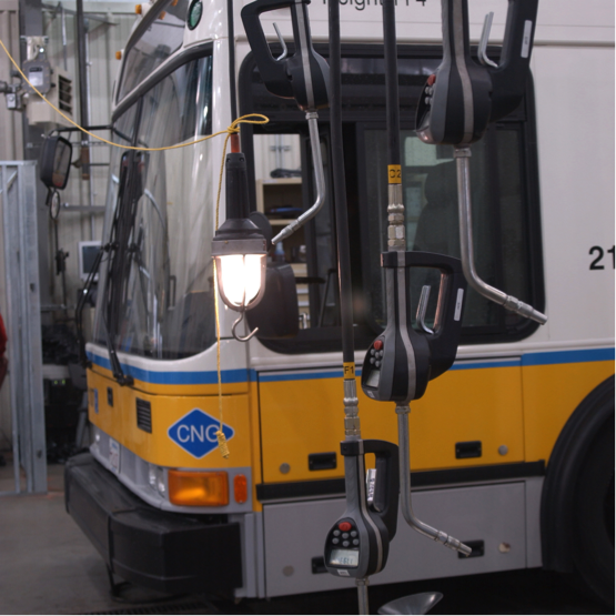
| Transit Agency: | MBTA |
|---|---|
Program/Project Name: |
Preventative Maintenance |
Air Quality Status: |
Exempt |
CO2 Impact: |
To Be Determined |
Project Description: |
Funds preventative maintenance on buses, vehicles, stations, and other MBTA facilities |
Year |
Funding Program |
Federal Funds |
Non-Federal Funds |
Total Funds |
|---|---|---|---|---|
2016 |
Section 5307 |
$12,000,000 |
$3,000,000 |
$15,000,000 |
2017 |
Section 5307 |
$12,000,000 |
$3,000,000 |
$15,000,000 |
2018 |
Section 5307 |
$12,000,000 |
$3,000,000 |
$15,000,000 |
2019 |
Section 5307 |
$12,000,000 |
$3,000,000 |
$15,000,000 |
|
Total Funding Programmed |
$48,000,000 |
$12,000,000 |
$60,000,000 |
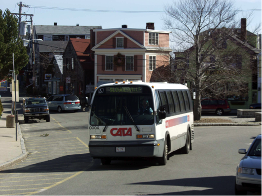
| Transit Agency: | CATA |
|---|---|
Program/Project Name: |
Preventative Maintenance |
Air Quality Status: |
Exempt |
CO2 Impact: |
To Be Determined |
Project Description: |
Funds preventative maintenance on buses, vehicles, and other CATA facilities. |
Year |
Funding Program |
Federal Funds |
Non-Federal Funds |
Total Funds |
|---|---|---|---|---|
2017 |
Section 5307 |
$400,000 |
$100,000 |
$500,000 |
2018 |
Section 5307 |
$400,000 |
$100,000 |
$500,000 |
2019 |
Section 5307 |
$400,000 |
$100,000 |
$500,000 |
|
Total Funding Programmed |
$1,200,000 |
$300,000 |
$1,500,000 |
| Transit Agency: | CATA |
|---|---|
Program/Project Name: |
Equipment and Facilities |
Air Quality Status: |
Exempt |
CO2 Impact: |
To Be Determined |
Project Description: |
Funds bus replacement and acquisition of support equipment. |
Year |
Funding Program |
Federal Funds |
Non-Federal Funds |
Total Funds |
|---|---|---|---|---|
2016 |
Section 5307 |
$0 |
$29,776 |
$29,776 |
2017 |
Section 5307 |
$135,390 |
$33,848 |
$169,238 |
2018 |
Section 5307 |
$140,744 |
$35,186 |
$175,930 |
2019 |
Section 5307 |
$146,152 |
$36,538 |
$182,690 |
|
Total Funding Programmed |
$422,286 |
$135,348 |
$557,634 |
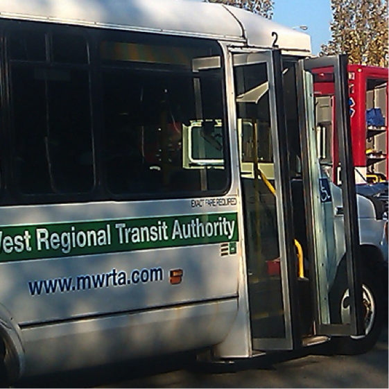
| Transit Agency: | MWRTA |
|---|---|
Program/Project Name: |
ADA Paratransit |
Air Quality Status: |
Exempt |
CO2 Impact: |
To Be Determined |
Project Description: |
Funds the operation of MWRTA’s non-fixed route ADA paratransit service. |
Year |
Funding Program |
Federal Funds |
Non-Federal Funds |
Total Funds |
|---|---|---|---|---|
2016 |
Section 5307 |
$1,300,000 |
$325,000 |
$1,625,000 |
2017 |
Section 5307 |
$1,300,000 |
$325,000 |
$1,625,000 |
2018 |
Section 5307 |
$1,300,000 |
$325,000 |
$1,625,000 |
2019 |
Section 5307 |
$130,000 |
$325,000 |
$455,000 |
|
Total Funding Programmed |
$4,030,000 |
$1,300,000 |
$5,330,000 |
| Transit Agency: | MWRTA |
|---|---|
Program/Project Name: |
Equipment and Facilities |
Air Quality Status: |
Exempt |
CO2 Impact: |
To Be Determined |
Project Description: |
Funds intermodal transit terminal improvements, signage, support vehicles, security equipment, and bus support equipiment. |
Year |
Funding Program |
Federal Funds |
Non-Federal Funds |
Total Funds |
|---|---|---|---|---|
2016 |
Section 5307 |
$458,056 |
$114,515 |
$572,571 |
2017 |
Section 5307 |
$423,415 |
$105,854 |
$529,269 |
2018 |
Section 5307 |
$423,415 |
$105,854 |
$529,269 |
2019 |
Section 5307 |
$423,415 |
$105,854 |
$529,269 |
|
Total Funding Programmed |
$1,728,301 |
$432,077 |
$2,160,378 |
Tracking and Demonstrating Progress Using Performance Measures
Increasingly, over the past two decades, transportation agencies have been applying “performance management”—a strategic approach that uses performance data to support decisions that would help achieve desired outcomes. Performance management is credited with improving project and program delivery, informing investment decision making, focusing staff on leadership priorities, and providing greater transparency and accountability to the public.
Performance-based planning and programming (PBPP) refers to transportation agencies’ application of performance management in their planning and programming processes to achieve desired performance outcomes for the multimodal transportation system. For MPOs, this includes a range of activities and products undertaken by a transportation agency together with other agencies, stakeholders, and the public as part of the 3C Metropolitan Transportation Planning Process. This includes developing:
The goal of PBPP is to ensure that transportation investment decisions—both long-term planning and short-term programming—are based on their ability to meet established goals.
The cornerstone of Moving Ahead for Progress in the 21st Century’s (MAP-21) highway program transformation is this movement to performance- and outcome-based results. States will invest resources in projects to achieve individual state targets that collectively will make progress toward national goals.
MAP-21 establishes national performance goals for federal highway programs:
The US Secretary of Transportation, in consultation with states, MPOs, and other stakeholders, have established performance measures for fatalities and serious injuries to fulfill the Highway Safety Improvement Program; proposed performance measures for pavement conditions for the Interstate and National Highway System (NHS), bridge conditions, and general performance of the Interstate and NHS; and drafted performance measures to assess traffic congestion and on-road mobile source emissions. States and MPOs will set performance targets to support these measures; and state and metropolitan plans will describe how program and project selection would help to achieve the targets.
The Boston Region MPO’s transition to performance-based planning is underway in anticipation of MAP-21 performance-measure requirements. The MPO has:
TABLE 4-1 National and MPO Performance Goals
National Goal |
Proposed MPO Goal |
|---|---|
Safety |
Safety |
Infrastructure Condition, System Reliability |
System Preservation |
Congestion Reduction |
Capacity Management/Mobility |
Environmental Sustainability |
Clean Air/Clean Communities |
Freight Movement/ Economic Vitality |
Economic Vitality |
The following sections of this chapter track performance measures and demonstrate how transportation investments for the next five years would advance the MPO’s goals and objectives.
Safety for all transportation modes continues to be a top priority for the MPO. The MPO goals commit to investing in projects and programs that reduce the severity of crashes and improve safety for all modes.
The MPO tracks traffic fatalities and serious injuries in the Boston region to examine past trends, identify regional safety issues, and set future targets for preferred performance. Tracking these measures help gauge the effectiveness of MPO transportation investments on reducing fatalities and serious injuries.
Overall, safety is improving in the region. Between 2006 and 2012, traffic fatalities (based on a rolling five-year average) decreased from 145 fatalities in 2006 to 129 in 2012. Figure 4-1 shows the change in traffic fatalities by mode during this time period and indicates that the 11 percent decline in fatalities included fewer automobile, truck, pedestrian, and bicycle fatalities. Similarly, total traffic crashes and injuries declined by 21 percent and 27 percent, respectively between 2006 and 2012.
FIGURE 4-1
Traffic Fatalities in the Boston Region by Mode, 2006–12
Sources: MassDOT, National Highway Traffic Safety Administration Fatality Reporting System, and the MassDOT Crash Data System.
Despite these overall gains, crashes and injuries for pedestrians and bicyclists rose during this same period, as shown in Figure 4-2. Between 2006 and 2012, roughly two-thirds of pedestrian and bicycle crashes resulted in an injury. For pedestrians, the number of crashes increased by 18 percent and injuries grew by 31 percent. For bicycles, the number of crashes increased by 36 percent and injuries jumped by 46 percent. In addition, there are still a number of high-crash locations throughout the Boston MPO region, including nearly 80 of the Top-200 Crash Locations statewide.
FIGURE 4-2
Traffic Injuries in the Boston Region by Mode, 2006–12
Sources: MassDOT, National Highway Traffic Safety Administration Fatality Reporting System, and the MassDOT Crash Data System.
In prioritizing its capital investments, the MPO uses TIP project-evaluation criteria to support the goal of improving safety for all modes. These criteria identify projects with great safety needs and assess whether proposed improvements address those needs. Projects with higher scores in the safety-evaluation criteria tend to address high-crash locations and be most effective at providing safety for all modes.
The projects programmed in the draft FFYs 2016-20 TIP Target Program propose safety improvements at 35 high-crash locations, and multiple truck, bicycle, and pedestrian high-crash locations to reduce fatalities and serious injuries in the region.
The FFYs 2016-20 TIP Target Program proposes three projects at 12 intersection locations. These intersection investments will provide safety improvements for automobiles, trucks, bicyclists, and pedestrians by implementing safety countermeasures at two high crash locations: Derby Street, Whiting Street (Route 53) and Gardner Street in Hingham and Middle Street, Libbey Industrial Parkway and Tara Drive in Weymouth.
The TIP Target Program proposes eight major infrastructure projects that would implement safety improvements at 19 high-crash locations, including seven truck high-crash locations.
The Route 128 Add-a-Lane project will widen 3.25 miles of I-95 in Needham and Wellesley to install an additional 12-foot travel lane and 10-foot shoulder in each direction will address serious safety issues. The addition of a fourth full-time travel lane will eliminate the usage of the breakdown lane during the peak periods and adding collector roads between Highland Avenue and Kendrick Streets will provide safer weaving movements between the interchanges.
The FFYs 2016-20 TIP Target Program proposes nine Complete Streets projects along corridors across the region. These corridor investments will provide safety improvements for automobiles, trucks, bicyclists, and pedestrians. Nine of the 13 Complete Streets projects would improve safety at one or more high-crash locations. In addition, improvements at these 13 corridors would provide safe and continuous accommodations for non-motorized users by adding 24 miles of new bicycle facilities and more than six miles of new sidewalk. For example, reconstructing Massachusetts Avenue in Lexington will add new bicycle lanes throughout this 0.7-mile section of the corridor, enhancing safe access to the Minuteman Commuter Bikeway. The Gateway East project along Route 9 in Brookline will provide added safety for bicyclists by implementing cycle tracks that physically separate the bicycle lane from the travel lane to reduce conflicts between motorists and bicyclists.
System preservation is a priority for the MPO because the transportation infrastructure in the region is aging. The demands placed on highway and transit facilities have been taxing to the point that routine maintenance is insufficient to keep up with the need. As a result, there is a significant backlog of maintenance and state-of-good repair work to be done on the highway and transit system, including bridges, roadway pavement, transit rolling stock, and traffic and transit control equipment.
MassDOT’s program monitors approximately 4,150 lane miles of interstate, arterial, and access-controlled arterial roadways in the Boston Region MPO area. It has been the policy of the MPO not to fund resurfacing-only projects in the TIP. However, the MPO does make funding decisions for roadway reconstruction projects that include resurfacing, usually deep reconstruction, in addition to other design elements.
An analysis of the pavement on MassDOT-maintained roadways in the Boston Region MPO area indicates that pavement condition has remained fairly constant between 2009 and 2013. Figure 4-3 displays the number of lane miles in good or better condition in the Boston Region MPO by roadway classification between 2009 and 2013. Figure 4-3 indicates that the lane miles of interstates, access-controlled arterials, and arterials in good or better condition has remained constant since 2009.
FIGURE 4-3
Lane Miles of Pavement in Good or Better Condition in the Boston Region MPO by Roadway Classification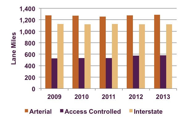
Source: MassDOT Pavement Management Program.
Approximately 70 percent of roadway lane miles are in good condition, 25 percent in fair condition, and five percent in poor condition—, which meets MassDOT’s performance, measure of at least 65 percent of the pavement in good condition. However, MassDOT-maintained arterial roadways continue to account for a disproportionate share of substandard roadway lane miles. Arterials accounted for 62 percent of the monitored roadways, but nearly 90 percent of the roadways that are in substandard condition (see Figure 4-4).
FIGURE 4-4
Pavement Condition in the Boston Region MPO by Roadway Classification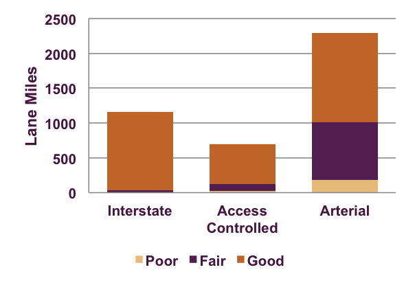
Source: MassDOT Pavement Management Program.
MassDOT also monitors the condition of its bridges across the state. There are 2,877 bridges located within the Boston Region MPO area. Of those bridges, some are in substandard condition because they have been deemed by MassDOT bridge inspectors as structurally deficient, functionally obsolete, or posted.
Figure 4-5 displays the number of substandard bridges in the Boston Region MPO by condition between 2007 and 2014. Figure 4-5 indicates that between 2007 and 2014, the percentage of structurally deficient bridges decreased slightly from six to five percent, functionally obsolete bridges remained constant at 19 percent, and posted bridges declined from seven to four percent.
FIGURE 4-5
Number of Substandard Bridges in the Boston Region MPO by Condition
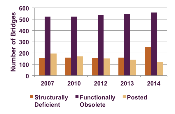
Source: MassDOT Bridge Inventory.
In prioritizing its capital investments, the MPO uses TIP project-evaluation criteria to assess how well each project improves pavement and signal condition to advance the MPO’s goal of maintaining a state of good repair.
Virtually all TIP Target Program investments advance the MPO’s system preservation goal to maintain the transportation system by improving pavement condition, or sidewalk infrastructure, or by prioritizing projects that improve emergency response or ability to respond to extreme conditions. In addition, the Target Program investments contribute modestly to bridge preservation by addressing 11 substandard bridges. Yet, the MassDOT Bridge Program remains the primary funding source for replacement or rehabilitation of substandard bridges,
The FFYs 2016-20 TIP Target Program investments propose to improve 67 miles of substandard pavement, 43 miles of sidewalk infrastructure, and 11 substandard bridges (10 functionally obsolete and one structurally deficient). In addition, there are 14 projects that will improve emergency response or ability to respond to extreme conditions, thus aiming to make significant progress toward maintaining the region’s transportation system.
The FFYs 2016-20 TIP Target Program proposes to improve substandard pavement at multiple intersections and modernizes signal equipment at 12 intersections. These investments will also improve emergency response by updating intersections along an evacuation route and in close proximity to emergency support locations.
The FFYs 2016-20 TIP Target Program proposes to resurface or reconstruct more than 30 miles of substandard pavement, more than 20 miles of sidewalk infrastructure, and one substandard bridge on arterial roadways. In addition, there are eight projects that will improve emergency response or ability to respond to extreme conditions, thus aiming to make significant progress toward maintaining the region’s transportation system.
The reconstruction of Ferry Street in Everett will resurface more than three miles of substandard pavement while bringing traffic signals, street lighting, signs and pavement markings into a state of good repair.
The FFYs 2016-20 TIP Target Program proposes to resurface or reconstruct 30 miles of substandard pavement, more than 20 miles of sidewalk infrastructure, and 10 substandard bridges. In addition, there are four projects that will improve emergency response or ability to respond to extreme conditions, thus aiming to make significant progress toward maintaining the region’s transportation system.
In addition, the reconstruction of Highland Avenue and Needham Street in Newton and Needham will resurface nine miles of substandard pavement, six miles of sidewalk infrastructure, and one substandard bridge, while bringing traffic signals, street lighting, signs, and pavement markings into a state of good repair.
The Route 128 Add-a-Lane project will replace one structurally deficient and three functionally obsolete bridges as part of the widening of I-95 in Needham and Wellesley.
Through its capacity management and mobility goal and objectives, the MPO seeks to maximize the region’s existing transportation system so that both people and goods can move reliably and connect to key destinations. The Boston region is mature, which creates challenges to making major infrastructure changes to its transportation system.
In order to determine how well the region’s roadways are performing, the MPO applies performance measures that gauge the duration, extent, intensity, and reliability of congestion. MPO staff analyzed congestion in the region using the CMP Express Highway and Arterial Performance Dashboards to establish a baseline for future comparison. Figure 4-6 displays the percentage of lane miles of congestion as measured by travel time index on the CMP expressway network. In the Boston Region MPO area, 22 percent of all expressway lane miles in the AM peak period and 20 percent of all expressway lane miles in PM peak period experience moderate-to-severe congestion.
The measure of lane miles of congestion was significantly less for the arterial network. Figure 4-7 displays the percentage of lane miles of congestion as measured by travel time index on the CMP arterial network. For the arterial network, only seven percent of arterials in the AM peak period and four percent of arterials in the PM peak period experience moderate to severe congestion.
FIGURE 4-6
Lane Miles of Congestion in the Boston Region MPO:
CMP Monitored Expressways
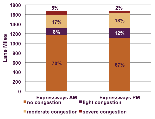
Source: Boston Region MPO Congestion Management Process.
Moving forward, the MPO will continue to monitor congestion data of the roadway network to track performance of the system. This annual analysis will depend on routinely updated data sources, which may require the purchase of INRIX data or other comparable data.
In prioritizing its capital investments, the MPO uses TIP project-evaluation criteria to assess how well each project expands transportation options to advance the MPO’s goal of managing capacity and improving mobility.
FIGURE 4-7
Lane Miles of Congestion in the Boston Region MPO:
CMP Monitored Arterials
Source: Boston Region MPO Congestion Management Process.
The MPO seeks to manage capacity on the transportation and improve mobility for its users by extending transit service to support non-SOV travel options, adding roadway capacity at select MPO-identified bottleneck locations, and implementing traffic and operational improvements along congested corridors.
The FFYs 2016-20 TIP Target Program proposes to add 24 miles of bicycle lanes (including almost a mile of cycle tracks), more than six miles of new sidewalk infrastructure, and improve access to transit along 10 corridors. These investments also would improve corridors that serve 18 bus routes, operating nearly 1,000 bus trips on a typical weekday. For example, the reconstruction of Route 126 (Pond Street) in Ashland will transform the corridor by adding sidewalks and bicycle lanes where no facilities currently exist. These improvements for bicyclists and pedestrians will provide the necessary facilities to support existing MWRTA bus services in the corridor.
The FFYs 2016-20 TIP Target Program proposes to add 24 miles of bicycle lanes, more than three miles of sidewalk infrastructure, and improve access to transit along five corridors. These investments also would improve corridors that serve multiple bus routes, operating more than 300 bus trips on a typical weekday.
Middlesex Turnpike Improvements (Phase III) in Bedford, Billerica, and Burlington will continue improvements to the corridor by adding three miles of sidewalks and bicycle lanes where no facilities currently exist. These improvements will support new LRTA bus service along the Middlesex Turnpike.
Reconstruction of Route 18 (Main Street) in Weymouth will improve one moderate MPO-identified arterial bottleneck location by widening a four-mile section of the corridor from two to four lanes. In addition, the project will expand transportation options by adding eight miles of bicycle lanes.
The Route 128 Add-a-Lane project will improve one severe MPO-identified express highway bottleneck location by widening 3.25 miles of I-95 in Needham and Wellesley.
Through its economic vitality goal, the MPO seeks to ensure that the transportation network provides a strong foundation for an economically vibrant region.
One of MetroFuture’s implementation strategies is to focus on economic growth, and coordinate transportation investments to guide economic growth in the region. MAPC worked with EOHED and the EOEEA to develop a process to identify local, regional, and state-level priority development and preservation areas in municipalities within the MPO area. MAPC staff worked with municipalities and state partners to identify locations throughout the region that are principal supporters of additional housing, employment growth, creation and preservation of open space, and the infrastructure improvements required to support these outcomes for each location.
This process identified locations that are best suited to support the type of continued economic vitality and future growth that the market demands, and which communities desire. Identifying these key growth and preservation locations also helps MAPC, the Boston Region MPO, and state agencies to understand both the infrastructure and technical assistance needs better, in order to help them prioritize the limited regional and state funding.
The MPO has not yet established performance measures to track the coordination of land-use development and transportation investments; however, the MPO uses TIP project-evaluation criteria to assess how well each project advances MetroFuture land-use planning. This means supporting investments in already-developed locations of residential or commercial/industrial activity, locations with adequate sewer and water infrastructure, areas identified for economic development by state, regional, and local planning, and areas with a relatively high density of development.
The MPO’s transportation investments advance economic vitality by prioritizing projects that support access to targeted development areas for multiple modes.
The FFYs 2016–20 TIP Target Program proposes nine projects that provide multimodal access to targeted development areas that are well suited to support continued economic vitality and future growth. For example, reconstruction of Route 85 (Maple Street) will provide access to a 43D site located at the former Lucent site in Marlborough and reconstruction of Route 27 (North Main Street) will provide access to a 40R site located at the former Paperboard site at 182 North Main Street in Natick.
The FFYs 2016-20 TIP Target Program proposes five projects that provide multimodal access to a targeted development areas well suited to support continued economic vitality and future growth.
The reconstruction of Rutherford Avenue in Boston, Route 18 (Main Street) in Weymouth, and Highland Avenue and Needham Street in Newton and Needham will expand transportation options and enhance access to transit to support future growth and facilitate new development.
Performance-based planning is an ongoing process and will continue to evolve as the MPO monitors and evaluates its progress using performance measures. The MPO will advance performance-based planning through its core planning documents by:
In FFY 2016, the MPO will continue to monitor system-level trends and propose performance targets to guide investment decisions. If, in its annual monitoring, the MPO sees it is not making progress toward its targets, then the organization would need to consider modifying investment or policy priorities, and weigh the tradeoffs involved. For example, allocating a greater share of funding to intersection improvements at high-crash locations may make significant progress toward reducing traffic fatalities and serious injuries; however, it also may impact the MPO’s ability to meet system-preservation targets for pavement or bridge conditions. By continuously monitoring and evaluating its progress, the MPO will be able to make these difficult decisions across competing goals and objectives in a more informed manner, resulting in greater outcomes for all concerned.
Determination of Air Quality Conformity
The Commonwealth of Massachusetts is classified as unclassifiable/attainment for the ozone standard with the exception of Dukes County. Therefore, the Boston Region MPO does not have to perform a conformity determination for ozone for its Long-Range Transportation Plan or Transportation Improvement Program.
The Boston area carbon monoxide (CO) maintenance area4, however, must maintain reduced emission levels of CO. With this maintenance classification, the 1990 Clean Air Act Amendments (CAAA) require the Boston Region MPO to conduct an air quality conformity analysis for the nine communities, as they have a carbon monoxide maintenance plan approved and included in the State Implementation Plan (SIP).
In April 2002, Waltham was redesignated as in attainment for carbon monoxide with a United States Environmental Protection Agency (EPA)-approved limited maintenance plan (see the Boston Region MPO’s Charting Progress to 2040 LRTP for more details).
The Boston Region MPO certifies that no activity outlined in its LRTP and TIP will:
Key elements of this FFYs 2016–2020 TIP related to air quality conformity are as follows:
Transportation control measures (TCMs) were required in the SIP in revisions submitted to the EPA in 1979 and 1982 and in those submitted as part of the Central Artery/Tunnel (CA/T) project. The TCMs included in the 1979 and 1982 submissions were accomplished through construction or implementation of ongoing programs.
The TCMs submitted as part of the CA/T project mitigation have been included in the conformity of the LRTP as recommended or completed projects with the exception of the following three projects:
MassDOT worked with the Massachusetts Department of Environmental Protection (DEP) to address these projects and continues to keep the Boston Region MPO informed of their status through monthly reports at the MPO’s regularly scheduled meetings. The Boston Region MPO will continue to include these projects in the LRTP and TIP until the process has been completed, assuming that any interim projects or programs will provide equal or better emissions benefits. When the process has been completed, the MPO will amend the LRTP and future TIPs and their conformity determinations to include any changes (including any interim projects or programs).
The status of these projects has been updated using the SIP Transit Commitments Status Report, which was submitted by MassDOT to DEP in May 2015. Highlights of the report are presented below. For a detailed description of the status of these projects, please visit MassDOT’s website at the following link:
Project Status
MassDOT initiated a process to amend the SIP to permanently and completely remove the obligation to perform final design of the Red Line-Blue Line Connector. To that end, MassDOT officially sought approval from DEP to support a SIP amendment process. MassDOT is not proposing to substitute any new projects in place of the Red Line-Blue Line Connector commitment, given the absence of any air-quality benefits associated with the current Red Line-Blue Line commitment (final design only). Correspondence from MassDOT to the DEP formally initiating the amendment process was submitted on July 27, 2011, and is posted on the MassDOT website.
On September 13, 2012, the DEP held two hearings (at 1:00 PM and 5:00 PM) to take public comment on MassDOT’s proposed amendments to 310 CMR 7.36, Transit System Improvements, including eliminating the requirement to complete final design of the Red Line-Blue Line Connector. Between the two hearings, there were 16 attendees, 10 of whom gave oral testimony. All those who spoke at the hearings were in favor of the DEP not removing the commitment. The DEP accepted written testimony until September 24, 2012.
On August 23, 2013, the EPA sent a letter to FHWA providing an update on Massachusetts Air Quality Conformity. In that letter, the EPA noted that the Red Line-Blue Line Connector Design project had not met the completion date on December 2011, but that MassDOT was not obligated to implement interim emission-reduction projects because no emission reductions are associated with the design project.
On October 8, 2013, the DEP approved a request made by MassDOT in July 2011 to revise 310 CMR 7.36 to remove the requirement for MassDOT to complete the design of the Red Line-Blue Line Connector. This revision to the State Implementation Plan must now also be approved by EPA. The text of the revision is available on the MassDOT website at: http://www.massdot.state.ma.us/Portals/17/docs/sip/October13UpdatedSIPReg.pdf.
On December 1, 2014, the EPA published a proposed rule to approve a SIP revision submitted by the Commonwealth of Massachusetts in the Federal Register on November 6, 2013. This proposal, if finalized, would remove the design of the Red Line- Blue Line Connector as a requirement in the SIP.
Funding Source
MassDOT is proposing to nullify this commitment
Project Status
The Four Corners and NewMarket Stations opened for service on July 1, 2013. One remaining claim must be processed for the Four Corners station and then the contract will be closed out. Final closeout is expected in July 2015. The Talbot Avenue Station opened in November 2012.
A station at Blue Hill Avenue has been the subject of significant community controversy during the past-five years. The redesign of the station is now moving forward, and is 60 percent complete. The 90 percent design plans are expected in July 2015 and 100 percent plans in September 2015. Construction is scheduled to begin in spring 2016, and the station to open in summer 2018.
MassDOT and the MBTA prepared a Petition to Delay and an Interim Emission Offset Plan to be implemented for the duration of the delay of the Fairmount Line Improvements project. MassDOT estimated the reduced emissions that are expected to be generated by implementing the new Fairmount Line station and, with input from Fairmount Line stakeholders, proposed offset measures. MassDOT estimated that the potential offset measures would meet emissions-reduction targets. The measures include shuttle bus service from Andrew Square to Boston Medical Center and increased service on bus Route 31, which serves Dorchester and Mattapan. These measures were implemented on January 2, 2012, and currently are in place.
Funding Source
The Commonwealth
Project Status
State-level environmental review (Massachusetts Environmental Policy Act (MEPA)) was completed in July 2010. Federal-level environmental review (National Environmental Policy Act (NEPA) documents were submitted to the Federal Transit Administration in September 2011, and a public hearing was held on October 20, 2011. A Finding of No Significant Impact (FONSI) was issued by the Federal Transit Administration (FTA) on July 9, 2012.
On January 5, 2015, the US Secretary of Transportation and the MBTA signed the Full Funding Grant Agreement (FFGA) for the Green Line Extension project, approving $996,121,000 of FTA New Starts funding to support design and construction of the project. The execution of the FFGA was the result of many years of planning, design and pre-construction efforts by MassDOT and the MBTA, in collaboration with the FTA and its Project Management Oversight Consultant. The federal funding is scheduled to be paid between FFY 2015 and FFY 2022. As noted in the current MassDOT Capital Investment Plan (released January 2014), MassDOT and the MBTA will use Commonwealth funds in addition to federal funding to support the design and construction activities.
To tailor the project-delivery method to best mitigate the larger project risks, MassDOT and MBTA are implementing a four-phased project-delivery plan:
Phase 1 is using the traditional design-bid-build approach to deliver the contract for widening the Harvard Street and Medford Street railroad bridges and demolishing the 21 Water Street building. The contract award occurred in December 2012, and the Notice to Proceed was issued on January 31, 2013.
The MBTA has also added some retaining wall construction to the Phase 1 contract that had previously been programmed for Phase 4 in that area. By constructing this work under the Phase 1 contract, this retaining/noise wall should be completed in time to better support and facilitate track relocation as part of the construction of Phase 4. The addition of this work has extended the end date of the Phase 1 contract by six months to October 2015, and as of this writing, the contractor is on track to complete it by then.
In Medford at Harvard Street, the new T2 track installation is almost complete and the track throw to the new T2 bridge alignment was competed on May 10, 2015. Road closure and demolition of the old T2 bridge structure was scheduled for the weekend of May 16 and 17. Once this demolition is complete, abutment modifications will commence for installation of the new Green Line outbound and inbound bridges. Noise barrier column and panel installation above the new cast-in-place retaining wall south of Winchester Court is also anticipated to begin in summer 2015.
Phase 2/2A will extend service from the (new) Lechmere Station to the Washington Street and Union Square Stations and relocate the bus facility and vehicle storage at Lechmere Station. The projected completion date for Phase 2/2A initial Green Line service is likely mid-2018.
Phase 3 will construct the vehicle-maintenance facility and storage facility. As the full yard and maintenance facility are not needed to support the initial passenger service to Washington Street and Union Square, this phase has been scheduled for completion approximately six months ahead of the date for revenue service to College Avenue.
Phase 4 will provide service from Washington Street Station (completed as part of Phase 2, above) to College Avenue Station, which was targeted to be completed in June 2020, roughly a year ahead of the FFGA completion date. Although enabling construction is already underway in this segment, the design of this package is being revised to incorporate value engineering scope changes. This reworking will extend the period to complete the 100% final design for pricing and may extend the bidding and award into early 2016, as opposed to the planned November 2015 Notice to Proceed (NTP) date.
New Green Line Vehicles: The MBTA Vehicle Procurement contract to purchase 24 Type 9 Vehicles was awarded to CAF USA Inc. in the amount not to exceed $118,159,822 at the MassDOT Board Meeting held on May 14, 2014. The NTP for this contract was issued on September 4, 2014.
CAF is in the process of developing drawing packages for the Preliminary Design, and the MBTA Project Team and the Contractor CAF continue to hold technical working sessions and project meetings. In addition, weekly project management meetings are held between MBTA and CAF to discuss project status, short-term schedules and priorities as well as monthly project status meetings where all project issues, schedules, deliverables and milestones are reviewed and discussed.
The first vehicle is to be delivered no later than 36 months from NTP. The pilot car delivery is scheduled for September 2017. The pilot car will receive comprehensive testing for six months followed by delivery of the remaining 22 vehicles, with the last car to be delivered by July 2018. All vehicles are expected to be in service in early 2019.
Somerville Community Path: Originally the Green Line Extension project included just the design of the extension of the Somerville Community Path from south of Lowell Street to the Inner Belt area of Somerville. In May 2014, MassDOT and the City of Somerville announced an agreement to add construction of the Community Path, including a connection to the Cambridge/Northpoint area, to the scope of the program. The Path Extension is not part of the SIP commitment.
Potential Challenges
MassDOT has met the first four interim milestones associated with the Green Line Extension project: 1) filing an Expanded Environmental Notification Form, 2) procuring multiple design consultants, 3) publishing Draft Environmental Impact Report, and 4) publishing Final Environmental Impact Report. The project has transitioned from planning and environmental review phases to design, engineering, and construction.
In the 2011 SIP Status Report, MassDOT reported that the Green Line Extension project would not meet the legal deadline of December 31, 2014. At that time, MassDOT projected a period for introducing passenger service on the Green Line Extension. The points within the period are associated with different probabilities, as shown below:
FTA’s projected completion date is June 2021, which includes one year of schedule contingency beyond the MBTA’s target date. Presently, the Green Line Extension team anticipates that the completion date of Phase 4 will be extended from June 2020 to late summer/early fall 2020.
MassDOT and the MBTA continue to seek measures to accelerate the project timeline wherever possible. The receipt of the FFGA was a key milestone, as it allowed completion of the bidding process and the start of construction for the bulk of the Phase 2/2A and Phase 4 work.
Although the goal of the phased project delivery approach is to complete components in an incremental way, the timeline for overall project completion listed above represents a substantial delay beyond the current SIP deadline of December 31, 2014. Consequently, this schedule triggers the need to provide interim emission reduction offset projects and measures for the period of the delay (beginning January 1, 2015). Working with the Central Transportation Planning Staff, MassDOT and the MBTA calculated the reductions of volatile organic compounds, CO, and nitrogen oxides—reductions equal to or greater than the reductions projected for the Green Line Extension itself, as specified in the SIP regulation—that will be required for the period of the delay.
In June 2012, MassDOT released a list of potential mitigation ideas received from the public that could be used as offset measures. In summer and fall of 2012, MassDOT solicited public comments on these potential measures. The MBTA created an internal working group to determine a final portfolio of interim mitigation measures to implement by December 31, 2014, the legal deadline for the implementation of the Green Line Extension.
This work resulted in a recommendation to implement the following three interim mitigation measures, which collectively would meet the emissions reduction target for the project:
The Petition to Delay, submitted to DEP on July 22, 2014, which expands further on the analysis and determination of the interim offset measures, is available on MassDOT’s website. These measures went into effect in the beginning of 2015.
Funding Source
The Commonwealth
Project Status
Former MassDOT Secretary of Transportation, Richard Davey, approved construction of the permitted ferry facility and a $460,000 ferry-service startup subsidy in October 2012. The 2005 facility plans and specifications were revised to meet the latest MassDOT Highway Division standards. The bid package was issued in fall 2013. A contractor was selected and the Notice to Proceed was issued in April 2014. Pre-construction activities progressed, but contractual issues have led MassDOT to decide to rebid the contract and complete the facility in 2015. There is no regularly scheduled passenger water transportation service in this area, nor are there any plans to provide such a service. The City of Boston, however, is undertaking design and engineering work to address the Old Northern Avenue Bridge's vessel-clearance constraint, and is purchasing two ferry vessels for Inner Harbor use, which could include this ferry terminal as a destination.
Funding Source
The Commonwealth
The primary conformity test is to show consistency with emissions budgets set forth in the SIP. Specific information regarding analysis methods, latest planning assumptions, and consultation procedures are detailed in the LRTP, Charting Progress to 2040.
A list of all of the regionally significant projects from the Boston Region MPO included in the air quality conformity determination for this TIP is shown in Tables 5-1 and 5-2.
Table 5-1
Regionally Significant Projects Included in the Regional Transportation Models for the Boston Region MPO
Projects under Construction
Analysis Year |
Community |
Project Descriptions |
|
|---|---|---|---|
2020 |
Needham and Wellesley |
Route 128 Additional Lanes |
|
Table 5-2
Regionally Significant Projects Included in the Regional Transportation Models for the Boston Region MPO
Recommended LRTP and TIP Projects
Analysis Year |
Community |
Project Descriptions |
|---|---|---|
2020 |
Bedford and Billerica |
Middlesex Turnpike Improvements, Phase 3 – from Crosby Drive north to Manning Road |
2020 |
Newton and Needham |
Reconstruction of Highland Avenue, Needham Street and Charles River Bridge, from Webster Street to Route 9 |
2020 |
Somerville and Medford |
Green Line Extension Project (Phase 2) from College Avenue to Mystic Valley Parkway/Route 16 |
2020 |
Weymouth and Abington |
Reconstruction and Widening of Route 18 (Main Street) From Highland Place to Route 139 |
2020 |
Woburn |
Reconstruction of Montvale Avenue from I-93 to Central Street |
2020 |
Woburn |
Bridge Replacement, New Boston Street Bridge over MBTA Tracks |
2020 |
Boston |
Reconstruction of Rutherford Avenue, from City Square to Sullivan Square |
2030 |
Framingham |
Intersection Improvements at Route 126 and Route 135/MBTA and CSX Railroad |
2030 |
Lexington |
Route 4/225 (Bedford Street) and Hartwell Avenue |
2030 |
Natick |
Bridge Replacement, Route 27 (North Main Street) over Route 9 (Worcester Street) and Interchange Improvements |
2030 |
Somerville |
McGrath Boulevard Project |
The primary test for showing conformity with the SIP is to demonstrate that the air-quality conformity of this TIP is consistent with the emission budget set forth in the SIP. The CO mobile-source attainment inventory for 1993, for the nine cities in the Boston maintenance area, reclassified being in attainment as 305.43 tons per winter day. The projection of mobile sources for the Boston maintenance area is 228.33 tons per winter day for 2010. Estimates of CO emissions for the Boston maintenance area for various years are shown in Table 5-3. The CO emissions are less than the CO emission budget.
Table 5-3
Winter CO Emissions Estimates for the CO Maintenance Area for the Nine Cities in the Boston Area (all emissions are in tons per winter day)
Year |
Boston Region Action Emission |
Emission Budget |
Difference (Action Minus Budget) |
|---|---|---|---|
2020 |
34.56 |
228.33 |
-193.77 |
2030 |
23.32 |
228.33 |
-205.01 |
2040 |
18.90 |
228.33 |
-209.43 |
In summary, this TIP is derived from a conforming LRTP, and the conformity determination has been prepared in accordance with EPA’s final conformity regulations. The Boston Region MPO has found that the emission levels from this FFYs 2016–20 TIP demonstrate conformity with the SIP. Therefore, the implementation of the FFYs 2016–20 TIP is consistent with the air quality goals in the Massachusetts SIP.
Financial Constraint
For financial constraint of the TIP, the transit and highway programs must be financially constrained to projections of available federal aid.
As shown in the tables below, the federal fiscal years 2016–20 TIP complies with financial constraint.
TABLE 6-1
The Federal-Aid Transit Program
Transit Program |
FFY 2016 |
FFY 2017 |
FFY 2018 |
FFY 2019 |
FFYs 2016–19 |
|---|---|---|---|---|---|
MBTA Section 5307 Authorization |
$142,258,223 |
$144,392,097 |
$146,557,978 |
$148,756,348 |
$581,964,646 |
MBTA Section 5307 Program |
$70,685,516 |
$70,685,516 |
$70,685,516 |
$70,685,516 |
$282,742,064 |
CATA Section 5307 Authorization |
$538,041 |
$546,111 |
$554,303 |
$562,618 |
$2,201,073 |
CATA Section 5307 Program |
$0 |
$535,390 |
$540,744 |
$546,152 |
$1,622,286 |
MWRTA Section 5307 Authorization |
$1,766,759 |
$1,793,260 |
$1,820,159 |
$1,847,462 |
$7,227,640 |
MWRTA Section 5307 Program |
$1,758,056 |
$1,723,415 |
$1,723,415 |
$1,723,415 |
$5,758,301 |
MBTA Section 5337 Authorization |
$122,065,594 |
$123,896,578 |
$125,755,026 |
$127,641,352 |
$499,358,550 |
MBTA Section 5337 Program |
$121,190,546 |
$121,190,546 |
$121,190,546 |
$121,190,546 |
$484,762,184 |
MBTA Section 5339 Authorization |
$5,818,872 |
$5,906,155 |
$5,994,748 |
$6,084,669 |
$23,804,444 |
MBTA Section 5339 Program |
$5,287,027 |
$5,287,027 |
$5,287,027 |
$5,287,027 |
$21,148,108 |
TABLE 6-2
The Federal-Aid Highway Regional Target Program
(Including state matching funds, but excluding earmarked funds)
Regional Target |
FFY 2016 |
FFY 2017 |
FFY 2018 |
FFY 2019 |
FFYs 2016–19 |
Regional Target Obligation Authority |
$75,009,821 |
$88,759,294 |
$92,626,333 |
$92,626,333 |
$349,021,781 |
Regional Target Programmed |
$75,009,821 |
$88,757,069 |
$92,721,968 |
$91,120,634 |
$347,609,492 |
STP Target |
$52,188,452 |
$67,723,275 |
$71,590,315 |
$72,353,684 |
$263,855,726 |
STP Programmed |
$29,146,362 |
$45,527,235 |
$56,195,374 |
$64,949,489 |
$195,818,460 |
NHPP Target |
N/A |
N/A |
N/A |
N/A |
N/A |
NHPP Programmed* |
$ 29,626,133 |
$13,360,000 |
$13,168,183 |
$0 |
$56,154,316 |
HSIP Target |
$4,296,710 |
$4,296,710 |
$4,296,710 |
$4,296,710 |
$17,186,840 |
HSIP Programmed |
$3,600,000 |
$7,761,213 |
$2,931,191 |
$5,583,037 |
$19,875,440 |
CMAQ Target |
$13,427,220 |
$13,427,220 |
$13,427,220 |
$13,427,220 |
$53,708,880 |
CMAQ Programmed |
$10,037,326 |
$16,937,401 |
$17,115,131 |
$18,039,390 |
$62,129,248 |
TAP Target |
$5,097,438 |
$3,312,089 |
$3,312,089 |
$2,548,719 |
$14,270,335 |
TAP Programmed |
$2,600,000 |
$5,171,220 |
$3,312,089 |
$2,548,719 |
$15,632,028 |
* National Highway Performance Program (NHPP) funds are from Surface Transportation Program (STP) target amounts.
TABLE 6-3
The Federal-Aid Bridge Program
Bridge Program |
FFY 2016 |
FFY 2017 |
FFY 2018 |
FFY 2019 |
FFYs 2016–19 |
|---|---|---|---|---|---|
Federal-Aid Bridges* |
$66,515,800 |
$52,833,304 |
$83,383,716 |
$55,383,716 |
$258,404,284 |
Operation and Maintenance
One requirement of Moving Ahead for Progress in the 21st Century (MAP-21) is the assessment of the operation and maintenance of the transportation system in the Boston region. State and regional agencies develop estimates of transit and highway operating and maintenance costs through their budgeting process. The information on projects and funding sources presented in Chapter 3 represents operations and maintenance estimates from the implementing agencies: the Cape Ann Transportation Authority (CATA), the MetroWest Regional Transit Authority (MWRTA), the Massachusetts Bay Transportation Authority (MBTA), and the MassDOT Highway Division. The tables on pages 7-2 and 7 -3 present the operations and maintenance expenditures for state fiscal years (SFYs) 2013 through 2015 for MassDOT projects. The tables on pages 7-4 through 7-6 present operations and maintenance expenditures for SFYs 2014 through 2017 for the MBTA, CATA, and the MWRTA.
1 Section 134 of the Federal-Aid Highway Act and Section 5303 of the Federal Transit Act, as amended.
2 MetroFuture is MAPC's 30-year plan for our region, which serves as a guide for work in all areas of the agency. The MetroFuture plan supports a vision of smart growth and regional collaboration through the promotion of efficient transportation systems, conservation of land and natural resources, improvement of residents’ health and education, and an increase in equitable economic-development opportunities for prosperity.
3 From the 23 Code of Federal Regulations (CFR) 450.324(e).
4 The Boston area carbon monoxide maintenance area includes Boston, Cambridge, Chelsea, Everett, Malden, Medford, Quincy, Revere, and Somerville.
Appendix A
Universe of Projects for Highway Discretionary (“Regional Target”) Funding & Evaluation Results
This appendix lists information about transportation projects that cities and towns in the region identified as their priority projects to be considered for funding through the Boston Region MPO’s Highway Discretionary (“Regional Target”) Program. It also contains the evaluation results of those projects scored by MPO staff based on the evaluation criteria.
Through an outreach process that seeks input from local officials and interested parties, the MPO staff compiles project requests and relevant information into a Universe of Projects list for the MPO. The Universe of Projects list includes projects in varied stages of development, from projects in the conceptual stage to those that are fully designed and ready to be advertised for construction. The MPO staff also collects data on each project in the universe to support the evaluation of projects.
The MPO’s project selection process uses evaluation criteria to make the process of selecting projects for programming in the TIP both more logical and more transparent. The criteria are based on the MPO’s visions and policies that were adopted for its Long-Range Transportation Plan (LRTP), Paths to a Sustainable Region.
The MPO staff uses the project information and evaluations to prepare a First-Tier List of Projects that have high ratings in the evaluation process and could be made ready for advertising in the time frame of the TIP. The MPO staff then prepares a staff recommendation for the TIP taking into consideration the First-Tier list and factors such as the construction readiness of the project, the estimated project cost, community priority, geographic equity (to ensure that needs are addressed throughout the region), and consistency with the MPO’s LRTP.
The MPO discusses the First-Tier List of Projects, the staff recommendation, and other information before voting on a draft TIP to release for a 30-day public review and comment period.
Table A-1 contains a summary of the evaluated projects in this year’s TIP development process. Projects that are programmed in the FFYs 2016-20 TIP are in bold type.
A full list of the Universe of Projects (including those project that were evaluated and those projects that were not evaluated) is contained in Table A-2. Projects in bold type are programmed in the FFYs 2016–20 TIP.
TABLE A-1: FFYs 2016-20 TIP - Summary of Evaluated Highway Projects
| TIP ID | Proponent(s) | Project Name | TIP/ LRTP Status |
Total Rating (154 Points Possible): |
System Preservation, Modernization, and Efficiency Rating (36 Points Possible): |
Livability and Economic Benefit Rating (29 Points Possible): |
Mobility Rating (25 Points Possible): |
Environment and Climate Change Rating (25 Points Possible): |
Environmental Justice Rating (10 Points Possible): |
Safety and Security Rating (29 Points Possible): |
| 606635 | Newton and Needham (MassDOT) | Reconstruction of Highland Avenue, Needham Street & Charles River Bridge, from Webster Street to Route 9 | 2018 | 104 | 30 | 17 | 13 | 18 | 6 | 20 |
| 606284 | Boston | Improvements to Commonwealth Avenue, from Amory Street to Alcorn Street | 2015 | 96 | 28 | 16 | 15 | 9 | 8 | 20 |
| 607981 | Somerville (MassDOT) | McGrath Boulevard Project | LRTP 2026-30 |
96 | 30 | 18 | 13 | 12 | 9 | 14 |
| 607652 | Everett | Reconstruction of Ferry Street | 2019 | 90 | 30 | 12 | 14 | 11 | 5 | 18 |
| 605034 | Natick | Reconstruction of Route 27 (North Main Street), from North Avenue to the Wayland town line | 2019 | 88 | 32 | 16 | 14 | 9 | 0 | 17 |
| 607409 | Lexington | Reconstruction on Massachusetts Avenue, from Marrett Road to Pleasant Street | 2016 | 87 | 30 | 10 | 15 | 8 | 6 | 18 |
| 29492 | Bedford, Billerica, and Burlington | Middlesex Turnpike Improvements, from Crosby Drive North to Manning Road (Phase III) | 2016-17 | 86 | 28 | 11 | 18 | 13 | 3 | 13 |
| 605146 | Salem | Reconstruction on Canal Street, from Washington Street and Mill Street to Loring Avenue and Jefferson Avenue | 2015 | 85 | 22 | 16 | 12 | 10 | 6 | 19 |
| 605110 | Brookline | Intersection and signal improvements at Route 9 and Village Square (Gateway East) | 2017 | 85 | 30 | 19 | 14 | 10 | 0 | 12 |
| 606043 | Hopkinton | Signal and intersection improvements on Route 135 | 2019 | 85 | 24 | 14 | 14 | 16 | 0 | 17 |
| 604810 | Marlborough | Reconstruction of Route 85 (Maple Street) | 2017 | 84 | 16 | 15 | 10 | 18 | 6 | 19 |
| 605313 | Natick (MassDOT) | Bridge replacement, Route 27 (North Main St.) over Route 9 (Worcester St.) and interchange improvements | LRTP 2021-25 |
84 | 34 | 12 | 15 | 8 | 0 | 15 |
| 606453 | Boston | Improvements on Boylston Street, from intersection of Brookline Avenue and Park Drive to Ipswich Street | 2019 | 83 | 16 | 18 | 14 | 16 | 5 | 14 |
| 605657 | Medway | Reconstruction on Route 109, from Holliston Street to 100 feet west of Highland Street | 2015 | 82 | 28 | 13 | 10 | 16 | 0 | 15 |
| 604123 | Ashland | Reconstruction on Route 126 (Pond Street), from the Framingham town line to the Holliston town line | 2020 | 77 | 20 | 16 | 9 | 11 | 6 | 15 |
| 602261 | Walpole (MassDOT) | Reconstruction on Route 1A (Main Street), from the Norwood town line to Route 27 | 2020 | 76 | 28 | 14 | 10 | 6 | 6 | 12 |
| 604652 | Winchester, Stoneham, and Woburn | Tri-Community Bikeway | 2015 | 75 | 20 | 15 | 9 | 17 | 0 | 14 |
| 604935 | Woburn | Reconstruction of Montvale Avenue, from I-93 Interchange to Central Street | 2017 | 75 | 30 | 10 | 9 | 8 | 0 | 18 |
| 605189 | Concord | Bruce Freeman Rail Trail, Phase 2C | 2016 | 73 | 24 | 14 | 10 | 10 | 2 | 13 |
| 604989 | Southborough | Reconstruction of Main Street (Route 30), from Sears Road to Park Street | 2017 | 73 | 22 | 13 | 12 | 11 | 0 | 15 |
| 602077 | Lynn | Reconstruction on Route 129 (Lynnfield Street), from Great Woods Road to Wyoma Square | 2019 | 73 | 20 | 8 | 14 | 9 | 5 | 17 |
| 607428 | Milford | Resurfacing and intersection improvements on Route 16 (Main Street), from Water Street to the Hopedale town line | 2019 | 73 | 22 | 12 | 13 | 4 | 6 | 16 |
| 607309 | Hingham | Reconstruction and related work on Derby Street from Pond Park Road to Cushing Street | 2017 | 71 | 22 | 9 | 15 | 8 | 0 | 17 |
| 606117 | Boston | Traffic signal improvements at 11 locations | 2016 | 71 | 20 | 13 | 12 | 7 | 5 | 14 |
| 601579 | Wayland | Signal and intersection improvements at Route 27 (Main Street) and Route 30 (Commonwealth Road) | 2016 | 70 | 24 | 10 | 10 | 12 | 0 | 14 |
| 601704 | Newton | Reconstruction and signal improvements on Walnut Street, from Homer Street to Route 9 | N/A | 70 | 24 | 16 | 8 | 7 | 0 | 15 |
| 601513 | Saugus (MassDOT) | Interchange reconstruction at Walnut Street and Route 1 (Phase II) | N/A | 69 | 22 | 12 | 15 | 7 | 0 | 13 |
| 1671 | Everett | Rehabilitation of Beacham Street | N/A | 69 | 20 | 10 | 8 | 9 | 4 | 18 |
| 604531 | Acton and Maynard | Assabet River Rail Trail | 2015 | 68 | 16 | 14 | 10 | 13 | 2 | 13 |
| 602310 | Danvers | Reconstruction on Collins Street, from Sylvan Street to Centre and Holten Streets | N/A | 68 | 20 | 13 | 14 | 6 | 2 | 13 |
| 605721 | Weymouth | Intersection improvements at Middle Street, Libbey Industrial Parkway and Tara Drive | 2016 | 68 | 20 | 12 | 16 | 5 | 0 | 15 |
| 604231 | Marlborough | Intersection and signal improvements on Route 20 (East Main Street/Boston Post Road) at Concord Road | N/A | 67 | 24 | 7 | 16 | 7 | 3 | 10 |
| 607255 | Holbrook | Intersection improvements and related work at Weymouth Street/Pine Street/Sycamore Street | N/A | 66 | 24 | 6 | 13 | 7 | 0 | 16 |
| 604377 | Gloucester | Washington Street and Railroad Avenue | N/A | 65 | 12 | 15 | 9 | 8 | 4 | 17 |
| 607888 | Boston | Multi-use path construction on New Fenway | 2019 | 65 | 6 | 17 | 11 | 13 | 5 | 13 |
| 604996 | Woburn | Bridge replacement, New Boston Street over MBTA | 2020 | 62 | 12 | 19 | 11 | 13 | 0 | 7 |
| 606002 | Duxbury | Signal installation at Route 3 (NB and SB) ramps and Route 3A (Tremont Street) | N/A | 61 | 24 | 4 | 17 | 3 | 0 | 13 |
| 607732 | Natick | Cochituate Rail Trail, Phase Two | 2018 | 60 | 6 | 14 | 10 | 12 | 3 | 15 |
| 600518 | Hingham (MassDOT) | Intersection improvements at Derby Street, Whiting Street (Route 53) and Gardner Street | 2018 | 59 | 22 | 10 | 13 | 2 | 0 | 12 |
| 606316 | Brookline | Pedestrian bridge rehabilitation over MBTA off Carlton Street | 2016 | 59 | 10 | 13 | 8 | 11 | 5 | 12 |
| 605857 | Norwood | Intersection improvements at Route 1 and University Avenue/Everett Street | N/A | 58 | 24 | 8 | 14 | 3 | 0 | 9 |
| 603739 | Wrentham | Construction of I-495/Route 1A ramps | N/A | 55 | 18 | 1 | 15 | 10 | 0 | 11 |
| 606130 | Norwood | Intersection improvements at Route 1A and Upland Road/Washington Street and Prospect Street/Fulton Street | N/A | 55 | 20 | 7 | 10 | 5 | 0 | 13 |
| 605743 | Ipswich | Resurfacing and related work on Central and South Main Streets | N/A | 51 | 10 | 13 | 8 | 6 | 0 | 14 |
| 604811 | Marlborough | Reconstruction of Route 20 (East Main Street), from Main Street easterly to Lincoln Street | N/A | 51 | 10 | 9 | 11 | 7 | 3 | 11 |
| 604638 | Danvers and Peabody (MassDOT) | Mainline improvements on Route 128 (Phase II) | N/A | 49 | 12 | 3 | 18 | 3 | 0 | 13 |
| 606501 | Holbrook | Reconstruction of Union Street (Route 139), from Linfield Street to Centre Street/Water Street | N/A | 48 | 10 | 13 | 7 | 5 | 0 | 13 |
| 601359 | Franklin | Reconstruction of Pleasant Street, from Main Street to Chestnut Street | N/A | 45 | 12 | 11 | 6 | 4 | 0 | 12 |
| 601607 | Hull | Reconstruction of Atlantic Avenue and related work, from Nantasket Avenue to Cohasset town line | N/A | 43 | 6 | 11 | 2 | 8 | 0 | 16 |
| 604745 | Wrentham | Reconstruction of Taunton Street (Route 152) | N/A | 36 | 6 | 10 | 2 | 4 | 0 | 14 |
TABLE A-2: FFYs 2016-20 TIP - Universe of Projects
| Proponent(s) | TIP ID | Project Name | TIP/LRTP Funding Status |
| Acton | 604531 | Assabet River Rail Trail | 2015 |
| Acton | 1656 | Intersection Improvements at Massachusetts Avenue (Route 111) and Main Street (Route 27) (Kelly's Corner) | |
| Ashland | 604123 | Reconstruction on Route 126 (Pond Street), from the Framingham T.L. to the Holliston T.L. | 2020 |
| Bedford | 607738 | Minuteman Bikeway Extension, from Loomis Street to the Concord T.L. | |
| Bedford, Billerica, and Burlington | 029492 | Middlesex Turnpike Improvements, from Crosby Drive North to Manning Road (Phase III) | 2016-17 |
| Beverly | 604369 | Reconstruction & Improvements on Route 128 (Interchange 19) at Brimbal Avenue, Sohier Road, Dunham Road, Otis Road | |
| Beverly | 607727 | Interchange Reconstruction at Route 128/Exit 19 at Brimbal Avenue (Phase II) | |
| Boston | 606284 | Improvements to Commonwealth Avenue, from Amory Street to Alcorn Street | 2015 |
| Boston | 604761 | Multi-Use Trail Construction (South Bay Harbor) From Ruggles Station to Fort Point Channel | |
| Boston | 606117 | Traffic Signal Improvements at 11 Locations | 2016 |
| Boston | 606226 | Reconstruction of Rutherford Avenue, from City Square to Sullivan Square | 2020 |
| Boston | 606453 | Improvements on Boylston Street, from Intersection of Brookline Avenue & Park Drive to Ipswich Street | 2019 |
| Boston | 607888 | Multi-use Path Construction on New Fenway | 2019 |
| Boston | 606134 | Traffic Signal Improvements on Blue Hill Avenue and Warren Street | 2018 |
| Boston | 605789 | Reconstruction of Melnea Cass Boulevard | 2018 |
| Boston | 601274 | Reconstruction of Tremont Street, from Court Street to Boylston Street | |
| Brookline | 605110 | Intersection & Signal Improvements at Route 9 & Village Square (Gateway East) | 2017 |
| Brookline | 606316 | Pedestrian Bridge Rehabilitation over MBTA off Carlton Street | 2016 |
| Brookline | 1659 | Emerald Necklace Bicycle and Pedestrian Crossings | |
| Burlington | 949 | Route 62 (Wilmington Road) | |
| Burlington | 950 | South Bedford Street | |
| Cambridge | 604993 | Innovation Boulevard Streetscape & Pedestrian Improvements, Between Main Street & Binney Street (Phase I) | |
| Canton | 900 | East-West Connector, between Pleasant St. & Route 138 | |
| Canton | 603883 | Reconstruction on Route 138, from I-93 to Dan Road | |
| Canton, Dedham, and Norwood (MassDOT) | 087790 | Interchange Improvements at I-95/I-93/University Avenue/I-95 Widening | |
| Canton, Dedham, and Westwood (MassDOT) | 606146 | Ramp Construction on I-95 (NB) & Improvements on Dedham Street, Includes Replacement of 4 Signalized Intersections | |
| Chelsea | 1443 | Reconstruction of Broadway, from City Hall Ave to the Revere City Line | |
| Chelsea | 1063 | Reconstruction of Beacham and Williams Streets, from Spruce Street to Everett City Line | |
| Chelsea | 953 | Reconstruction and Widening of Spruce Street, between Everett Avenue and Sixth Street | |
| Chelsea | 1615 | Spruce Street/Second Street/Carter Street Improvements | |
| Cohasset | 608007 | Corridor Improvements and Related Work on Justice Cushing Highway (Route 3A), from Beechwood Street to the Scituate Town Line | |
| Cohasset, Marshfield, and Scituate (MassDOT) | 605664 | Resurfacing & Related Work on Route 3A | |
| Concord | 605189 | Bruce Freeman Rail Trail, Phase 2C | 2016 |
| Concord and Acton | 606223 | Bruce Freeman Rail Trail Construction (Phase II-B) | 2018 |
| Concord | 1441 | Route 62 (Main St) Phase 3 | |
| Concord | 1450 | Route 117 (Fitchburg Turnpike) | |
| Concord | 602091 | Improvements & Upgrades to Concord Rotary (Routes 2/2A/119) | |
| Danvers | 602310 | Reconstruction on Collins Street, from Sylvan Street to Centre & Holten Streets | |
| Dedham | 607899 | Pedestrian Improvements along Bussey Street | |
| Dedham | 607901 | Pedestrian Improvements along Elm Street & Rustcraft Road Corridors | |
| Duxbury | 942 | Intersection Improvements at Route 3A & Route 139 | |
| Duxbury | 600650 | Route 3A (Tremont Street) Bridge | |
| Duxbury | 606002 | Signal Installation at Route 3 (NB & SB) Ramps & Route 3A (Tremont St) | |
| Everett | 607652 | Reconstruction of Ferry Street, South Ferry Street and a Portion of Elm Street | 2019 |
| Everett | 1671 | Rehabilitation of Beacham Street, from Route 99 to the Chelsea City Line | |
| Everett and Malden | 649 | TeleCom Boulevard, Phase 2 | |
| Framingham | 356 | Reconstruct Route 126 (Hollis Street), from Irving Street to the Ashland town line | |
| Framingham | 955 | Reconstruction of Route 126, from Route 9 to Lincoln Street | |
| Framingham | 602038 | Edgell Road Corridor Project | |
| Framingham | 606109 | Intersection Improvements at Route 126/135/MBTA & CSX Railroad | LRTP 2026-30 |
| Framingham | 608006 | Pedestrian Hybrid Beacon Installation at Route 9 and Maynard Road | |
| Franklin | 601359 | Reconstruction of Pleasant Street, from Main Street to Chestnut Street | |
| Franklin | 607774 | Resurfacing & Intersection Improvements on Route 140, from Beaver Street to I-495 Ramps | |
| Gloucester | 604377 | Washington Street And Railroad Avenue | |
| Hingham | 607309 | Reconstruction and Related Work on Derby Street from Pond Park Road to Cushing Street | 2017 |
| Hingham (MassDOT) | 600518 | Intersection Improvements at Derby Street, Whiting Street (Route 53) and Gardner Street | 2018 |
| Holbrook | 606501 | Reconstruction of Union Street (Route 139), from Linfield Street to Centre Street/Water Street | |
| Holbrook | 607255 | Intersection Improvements and Related Work at Weymouth Street/Pine Street/Sycamore Street | |
| Holbrook | 602260 | Intersection Improvements at Abington Avenue and Plymouth Street | |
| Holliston | 602462 | Signal Installation at Route 16/126 and Oak Street | |
| Hopkinton | 606043 | Signal & Intersection Improvements on Route 135 | 2019 |
| Hudson | 1047 | South Street | |
| Hudson | 1488 | Lincoln St. at Cox St. and Packard St. | |
| Hudson | 1617 | Route 85/ Route 62 Rotary Improvements | |
| Hudson (MassDOT) | 601906 | Bridge Replacement, Cox Street over the Assabet River | |
| Hudson and Marlborough (MassDOT) | 603345 | Reconstruction on Routes I-290 & 495 and Bridge Replacement | |
| Hull | 601607 | Reconstruction of Atlantic Avenue and Related Work, from Nantasket Avenue to Cohasset Town Line | |
| Ipswich | 605743 | Resurfacing & Related Work on Central & South Main Streets | |
| Lexington | 607409 | Reconstruction on Massachusetts Avenue, from Marrett Road to Pleasant Street | 2016 |
| Lexington | 604619 | Route 4/225 (Bedford Street) and Hartwell Avenue | LRTP 2021-25 |
| Lexington | 1141 | West Lexington Greenway | |
| Littleton | 1460 | Harvard Street | |
| Lynn | 602077 | Reconstruction on Route 129 (Lynnfield Street), from Great Woods Road to Wyoma Square | 2019 |
| Lynn | 601138 | Traffic Signals at 4 Locations (Contract E) | |
| Lynn | 943 | Broad Street/Lewis Street /Route 129 | |
| Lynn | 944 | Boston Street -Hamilton Street | |
| Lynn | 1319 | Route 129 (Boston St./Washington St.) | |
| Lynn | 1320 | Route 1 (Copeland Circle, Fox Hill Bridge) | |
| Lynn | 1321 | Route 1A Lynnway at Blossom Street | |
| Lynn | 1322 | Route 1A Lynnway intersection at Market St. | |
| Lynn | 1323 | Route 1A Lynn (GE Bridge Nahant Rotary) | |
| Lynn | 1324 | Blue Line Extension (Wonderland connection) | |
| Lynn | 1454 | Route 1 South (Jug handle lights at Goodwin Circle) | |
| Lynn | 602081 | Route 107 (Western Avenue)/Eastern Avenue | |
| Lynn | 602093 | Route 107 (Western Avenue) | |
| Lynn | 1672 | Blossom Street Ferry Terminal | |
| Lynn (MBTA) | 374 | Lynn Garage | |
| Lynn, Malden, Revere, and Saugus | 351 | Bike to the Sea, Phase 2 | |
| Lynnfield and Wakefield | 607329 | Rail Trail Extension, from the Galvin Middle School to Lynnfield/Peabody Town Line | 2018 |
| Malden, Revere, and Saugus (MassDOT) | 605012 | Reconstruction & Widening on Route 1, from Route 60 to Route 99 | |
| Marblehead | 1657 | Intersection Improvements to Pleasant Street at Village/Vine/Cross Streets | |
| Marlborough | 604810 | Reconstruction of Route 85 (Maple Street) | 2017 |
| Marlborough | 604811 | Reconstruction of Route 20 (East Main Street), from Main Street Easterly to Lincoln Street | |
| Marlborough | 604231 | Intersection & Signal Improvements on Route 20 (East Main Street/Boston Post Road) at Concord Road | |
| Marshfield (MassDOT) | 604655 | Bridge Replacement, Beach Street over the Cut River | 2018 |
| Medford | 1146 | Medford Square Parking | |
| Medford | 1455 | Medford Square Phase 2 Improvements | |
| Medford | 1456 | Medford Square Water Taxi Landing and Related Park Improvements | |
| Medford | 1457 | Medford Square Transit Center | |
| Medford | 1458 | Mystic River Linear Park | |
| Medway | 605657 | Reconstruction on Route 109, from Holliston Street to 100 Feet West of Highland Street | 2015 |
| Medway | 1167 | Route 109 (Milford Street) | |
| Medway | 602134 | Resurfacing & Related Work on a Section of Village Street | |
| Melrose | 601551 | Intersection & Signal Improvements at Main Street & Essex Street | |
| Milford | 607428 | Resurfacing & Intersection Improvements on Route 16 (Main Street), from Water Street to the Hopedale T.L. | 2019 |
| Milford | 967 | Veteran's Memorial Drive/Alternate Route | |
| Milford | 608045 | Rehabilitation on Route 16, from Route 109 to Beaver Street | |
| Millis | 602364 | Reconstruction of Village Street, from Main Street (Route 109) to the Medway Town Line | |
| Natick | 605034 | Reconstruction of Route 27 (North Main Street), from North Avenue to the Wayland Town Line | 2019 |
| Natick | 607732 | Cochituate Rail Trail, Phase Two | 2018 |
| Natick | 605313 | Bridge Replacement, Route 27 (North Main Street) over Route 9 (Worcester Street) and Interchange Improvements | LRTP 2021-25 |
| Needham and Wellesley (MassDOT) | 603711 | Rehab/Replacement of 6 Bridges on I-95/Route 128 (Add-a-Lane Contract 5) | 2015-18 |
| Newton and Needham | 606635 | Reconstruction of Highland Avenue, Needham Street & Charles River Bridge, from Webster Street to Route 9 | 2018 |
| Newton | 601704 | Reconstruction & Signal Improvements on Walnut Street, from Homer Street to Route 9 | |
| Newton | 1067 | Washington Street, Phase 2 | |
| Newton | 600932 | Reconstruction on Route 30 (Commonwealth Avenue), from Weston Town Line to Auburn Street | |
| North Reading | 1673 | Reconstruction of Route 28 (Main Street), from Larch Road to Route 62 (Lowell Road) | |
| North Reading | 1674 | Reconstruction of Route 62, from Route 28 (Main Street) to I-93 | |
| Norwood | 605857 | Intersection Improvements at Route 1 & University Avenue/Everett Street | |
| Norwood | 606130 | Intersection Improvements at Route 1A & Upland Road/Washington Street & Prospect Street/Fulton Street | |
| Norwood | 608052 | Intersection and Traffic Signal Improvements at Providence Highway (Route 1) and Morse Street | 2019 |
| Peabody (MassDOT) | 604638 | Mainline Improvements on Route 128 (Phase II) | |
| Peabody and Salem | 1655 | Riverwalk/Greenway from Peabody Square to Salem Train Depot | |
| Quincy | 1451 | Quincy Center Multimodal MBTA Station | |
| Salem | 605146 | Reconstruction on Canal Street, from Washington Street & Mill Street to Loring Avenue & Jefferson Avenue | 2015 |
| Salem | 1311 | Canal Street Bikeway | |
| Salem | 005399 | Reconstruction of Bridge Street, from Flint Street to Washington Street | |
| Salem | 600986 | Boston Street | |
| Saugus | 601513 | Interchange Reconstruction at Walnut Street & Route 1 (Phase II) | |
| Somerville (MassDOT) | 607981 | McCarthy Boulevard Construction | LRTP 2026-30 |
| Somerville (MassDOT) | 600831 | I-93 Mystic Avenue Interchange (Design and Study) | |
| Somerville and Medford (MBTA) | 1569 | Green Line Extension Project (Phase II), College Avenue to Mystic Valley Parkway/Route 16 | 2016-20 |
| Southborough | 604989 | Reconstruction of Main Street (Route 30), from Sears Road to Park Street | 2017 |
| Southborough | 1064 | Cordaville Road/Route 85 Rehabilitation | |
| Southborough and Westborough (MassDOT) | 607701 | Improvements at I-495 & Route 9 | |
| Stow and Hudson | 1139 | Assabet River Rail Trail | |
| Sudbury (MassDOT) | 607249 | Intersection Improvements at Route 20 & Landham Road | |
| Sudbury | 1037 | Route 20/Horsepond Road | |
| Sudbury | 1069 | Route 20/Wayside Inn Road | |
| Sudbury | 1164 | Bruce Freeman Rail Trail, Phase 2D | |
| Sudbury | 1305 | Bruce Freeman Rail Trail, Phase 2E | |
| Walpole | 602261 | Reconstruction on Route 1A (Main Street), from the Norwood Town Line to Route 27 | 2020 |
| Walpole | 600671 | Reconstruction of Route 1A, from Common Street to the Norfolk Town Line | |
| Walpole | 1151 | Walpole Central Business District | |
| Walpole | 1152 | Elm St Improvements | |
| Walpole (MassDOT) | 997 | Coney Street Interchange with Route 95 | |
| Watertown | 607777 | Rehabilitation of Mount Auburn Street (Route 16) | |
| Wayland | 601579 | Signal & Intersection Improvements at Route 27 (Main Street) and Route 30 (Commonwealth Road) | 2016 |
| Weymouth | 601630 | Reconstruction & Widening on Route 18 (Main Street), from Highland Place to Route 139 | 2016-19 |
| Weymouth | 605721 | Intersection Improvements at Middle Street, Libbey Industrial Parkway and Tara Drive | 2016 |
| Weymouth | 607755 | Intersection & Signal Improvements at 2 Locations: SR 53 (Washington Street) at Mutton Lane & Pleasant Street | 2016 |
| Wilmington | 608051 | Reconstruction on Route 38 (Main Street), from Route 62 to the Woburn C.L. | |
| Winchester, Stoneham, and Woburn | 604652 | Tri-Community Bikeway | 2015 |
| Winthrop | 607244 | Reconstruction & Related Work along Winthrop Street & Revere Street Corridor | |
| Woburn | 604935 | Reconstruction of Montvale Avenue, from I-93 Interchange to Central Street | 2017 |
| Woburn | 604996 | Bridge Replacement, New Boston Street over MBTA | 2020 |
| Woburn | 1153 | Woburn Loop Bikeway Project | |
| Woburn | 1449 | Route 38 (Main St.) Traffic Lights | |
| Woburn | 608067 | Intersection Reconstruction at Route 3 (Cambridge Road) & Bedford Road and South Bedford Street | |
| Woburn | 608097 | Bridge Replacement & Related Work, W-43-028, Washington Street over I-95 | |
| Woburn (MassDOT) | 605605 | Interchange Improvements to I-93/I-95 | |
| Wrentham (MassDOT) | 603739 | Construction of I-495/Route 1A Ramps | |
| Wrentham | 604745 | Reconstruction of Taunton Street (Route 152) |
Appendix B
Roadway Project Funding Application Forms & Evaluations
This appendix provides an explanation of the project funding application form for roadway projects that is used to understand requests for funding and to evaluate projects for possible programming. MPO staff and project proponents update these project funding application forms when new information becomes available. The forms are used to evaluate projects using criteria that reflect MPO visions and policies. Some information is provided specifically by the project proponent and other information is provided by MPO staff or by various state agencies.
Project funding application forms are available on the MPO website, http://www.ctps.org/. Proponents enter the project information on-line. Other information is input by MPO staff or automatically updated through links to other databases.
The MassDOT Project Information System (PROJIS) number assigned to the project. If the project does not have a PROJIS number, an identification number will be assigned to the project by the MPO for internal tracking purposes.
The municipality (or munipalities) in which the project is located.
The name of the project. (Source: MassDOT)
(determined by MPO staff):
The MassDOT Highway District in which the project is located.
The MAPC subregion in which the project is located.
The MAPC community type in which the project is located as defined by land use and housing patterns, recent growth trends, and projected development patterns.
The estimated total cost of the project. (Source: MassDOT)
The number of points scored by the project, if it has been evaluated.
A description of the project, including its primary purpose, major elements and geographic limits. (Source: MassDOT).
Total length of project in miles.
Total lane miles of project.
The priority rank of the project as determined by the community. (Source: Proponent)
Past UPWP-funded studies or reports conducted within the project area.
The air quality status of the project in the MPO’s travel demand model. Projects with “exempt” status do not add capacity to the transportation system. Projects with “model” status add capacity to the transportation system and are included in the travel demand model.
“Readiness” is a determination of the appropriate year of programming for a project. In order to make this determination, the MPO tracks project development milestones and coordinates with the MassDOT Highway Division to estimate when a project will be ready for advertising.
All non-transit projects programmed in the first year of the Transportation Improvement Program (TIP) must be advertised before the end of the federal fiscal year (September 30). That funding authorization is not transferred to the next federal fiscal year, therefore any “leftover” funds are effectively “lost” to the region. If a project in the first year of the TIP is determined as “not ready to be advertised before September 30,” it will be removed from the TIP and replaced with another project by amendment.
For projects in the first year of the TIP, it is important to communicate any perceived problems to the Boston Region MPO as soon as possible.
Advertised, Programmed, Pre-TIP, or Conceptual (Source: MPO database):
The year that a functional design report was completed, if one has been conducted for the project.
Current design status of the project in the MassDOT Highway Division Design Process. Dates are provided where available. (Source: MassDOT Project Info)
(Source: MassDOT Project Info):
Required – ROW action is required for completion of the project
Not Required – No ROW action required for completion of the project
(Source: MassDOT Project Info):
MassDOT Responsibility – Providing the required right-of-way is the responsibility of MassDOT.
Municipal Responsibility – Providing the required right-of-way is the responsibility of the municipality.
Municipal Approval – Municipal approval has been given to the right-of-way plan (with date of approval):
(Source: MassDOT Project Info):
Expected – Expected date of ROW plan and order of taking
Recorded – Date the ROW plan and order of taking were recorded at the Registry of Deeds
Expires – Expiration date of the rights of entry, easements, or order of taking
Permits required by the Massachusetts Environmental Policy Act (MEPA). (Source: MassDOT Project Info.) Possible required permits include:
System Preservation, Modernization, and Efficiency of our roadway is important to the vitality of our region. The evaluation criteria below serve as a way to measure the MPO’s efforts to emphasize the preservation, modernization and efficiency of the existing transportation system. The MPO has expressed these measures in the following policies:
(Source: MassDOT Roadway Inventory File)
Pavement Roughness (IRI) – International Roughness Index (IRI) rating reflects the calibrated value in inches of roughness per mile. IRI ratings are classified as follows:
Existing signal equipment condition. (Source: CMP, Massachusetts permitted signal information, municipal signal information, submitted design).
Identifies a project that is located within a Boston Region MPO Congestion Management Process (CMP) area.
Please include additional pavement information from municipal pavement management programs. In addition, qualitative descriptions of existing problems or anticipated needs can be provided. When applicable, this information should be consistent with project need information provided in the MassDOT Project Need Form. (Source: Proponent)
Please include detail regarding the pavement management system employed by the community or agency, and of how this system will maximize the useful life of any pavement repaired or replaced by the project. (Source: Proponent)
System Preservation, Modernization and Efficiency Evaluation Scoring (36 total points possible):
Improves substandard pavement (up to 6 points)
+6 IRI rating greater than 320: Poor and pavement improvements are included in the project
+4 IRI rating between 320 and 191: Fair and pavement improvements are included in the project
0 IRI rating less than 190: Good or better
Improves substandard signal equipment condition (up to 6 points)
+6 Poor condition and all equipment will be replaced
+4 Mediocre condition, replacement of majority of equipment will occur
+2 Fair condition, partial replacement will occur
0 All other values
Improves traffic signal operations (signal equipment upgrades, including for adaptive signal controls and coordination with adjacent signals (ITS) (up to 6 points)
+6 Meets or addresses criteria to a high degree
+4 Meets or addresses criteria to a medium degree
+2 Meets or address criteria to a low degree
0 Does not meet or address criteria
In a Congestion Management Process Identified Area (up to 6 points)
+6 CMP data indicates project area is in one of the most highly congested project areas monitored
+4 CMP data indicates project area is in one of the most congested project areas monitored
+2 CMP data indicates project area is in a congested project areas monitored
0 CMP data indicates project area is in the top 80 to 51 % of the most congested project areas monitored
Improves intermodal accommodations/connections to transit (up to 6 points)
+6 Meets or addresses criteria to a high degree
+4 Meets or addresses criteria to a medium degree
+2 Meets or address criteria to a low degree
0 Does not meet or address criteria
Implements ITS strategies other than traffic signal operations (improve traffic flow as identified by an ITS strategy for the municipality or state (e.g. variable message signs) (up to 6 points)
+6 Meets or addresses criteria to a high degree
+4 Meets or addresses criteria to a medium degree
+2 Meets or address criteria to a low degree
0 Does not meet or address criteria
The livability and economic benefit of our roadway is important to the vitality of our region. The evaluation criteria below serve as a way to measure the MPO’s efforts to emphasize and implement their livability policies. The MPO has expressed these measures in the following policies:
Using the current available zoning coverage, the following calculations will be made by MAPC:
(Source: MassDOT Bicycle Facility Inventory and Roadway Inventory File and MPO bicycle GIS coverage)
Pedestrian Facilities:
For all new development, a Transportation demand management (TDM) program is required that implements at least four of the following components:
In addition, this criteria can be met if the community is taking steps to significantly reduce single-occupant travel as part of the project or in the project area.
A targeted development area is located within ½ mile of the project area. Eligible targeted development areas include 43D, 43E, and 40R sites, Regionally Significant Priority Development Areas, Growth District Initiatives, and MBTA transit station areas.
The proposed project will improve access to or within a commercial district served by a Main Street organization, local business association, Business Improvement District, or comparable, geographically targeted organization (i.e., not a city/town-wide chamber of commerce).
Describe what improvements are in the project for pedestrians, bicyclists, and public transportation, and what level of improvement will be achieved over existing conditions. (Source: Proponent)
Explain how this project will support existing or proposed local land use policies. (Source: Proponent)
Will the project have an impact on adjacent land uses? Please review the land use information if the project is expected to have an impact on land use. Is there a local project currently under development that would provide a better balance between housing and jobs in this corridor? If so, please provide details on the project status. (Source: Proponent)
Explain how this project will support economic development in the community or in the project area (Source: Proponent)
Livability and Economic Benefit Evaluation Scoring (29 total points possible):
Design is consistent with complete streets policies (up to 4 points)
+1 Project is a “complete street”
+1 Project provides for transit service
+1 Project provides for bicycle facilities
+1 Project provides for pedestrian facilities
0 Does not provide any complete streets components
Provides multimodal access to an activity center (up to 3 points)
+1 Project provides transit access (within a quarter mile) to an activity center
+1 Project provides bicycle access to an activity center
+1 Project provides pedestrian access to an activity center
0 Does not provide multimodal access
Reduces auto dependency (up to 8 points)
+3 Project provides for a new transit service
+1 Project is identified in MassDOT’s Bay State Greenway Priority 100
+1 Project completes a known gap in the bicycle or pedestrian network
+1 Project provides for a new bicycle facility
+1 Project provides for a new pedestrian facility
+1 Project implements a transportation demand management strategy
0 Does not provide for any of the above measures
Project serves a targeted development site (40R, 43D, 43E, Regionally Significant Priority Development Area, Growth District Initiative, or eligible MBTA transit station areas) (up to 6 points)
+2 Project provides new transit access to or within a site
+1 Project improves transit access to or within a site
+1 Project provides for bicycle access to or within a site
+1 Project provides for pedestrian access to or within a site
+1 Project provides for improved road access to or within a site
Provides for development consistent with the compact growth strategies of MetroFuture (up to 5 points)
+2 Project mostly serves an existing area of concentrated development+1 Project partly serves an existing area of concentrated development
+1 Project complements other local efforts to improve design and access
+2 Project complements other local financial or regulatory support to foster economic revitalization
0 Does not provide for any of the above measures
Project improves Quality of Life (up to 3 points)
+1 Reduces cut through within the project area
+1 Implements traffic calming measures
+1 Improves the character of the project area
Increased travel choices and improved access for and across all modes—pedestrian, bicycle, public transportation, and vehicular—is a key mobility issue. Mobility is not merely about moving motor vehicles more quickly through an intersection or along a roadway segment, but includes increasing access and promoting use of all modes. The evaluation criteria below serve as a way to measure the MPO’s efforts to emphasize and implement their mobility policies. The MPO has expressed these measures in the following policies:
Identifies the fixed route transit vehicles using the roadway
Travel Time Index directly compares peak-period travel time conditions with free-flow travel time conditions. Travel time Index indicates how much contingency time should be considered to ensure an on-time arrival during the peak period versus optimum travel times.
Travel time index = average peak-period travel time / free-flow travel time
Information provided is determined by the Boston Region MPO’s CMP Arterial Performance Dashboard. If a Project Funding Application Form does not have any CMP data listed, this does not necessarily mean that the roadway or intersection does not experience congestion problems; this simply means that data from the CMP are not available.
Speed index is equal to the average speed divided by the posted speed limit of a Traffic Message Channel (TMC). Speed index indicates congestion more accurately than travel speeds alone because low travel speeds may be a result of low speed limits on certain facilities.
Speed Index = average speed / posted speed limit
Information provided is determined by the Boston Region MPO’s CMP Arterial Performance Dashboard. If a Project Funding Application Form does not have any CMP data listed, this does not necessarily mean that the roadway or intersection does not experience congestion problems; this simply means that data from the CMP are not available.
**Please refer to the CMP Arterial Performance Dashboard (hyperlink to http://www.ctps.org/map/www/apps/arterialHighwayPerformanceDashboard/index.html) for data on roadway congestion in the MPO region.
Describe the need for the project from a local and a regional perspective. What are the existing or anticipated mobility needs the project is designed to address? Please include information on how the project improves level of service and reduces congestion, provides multimodal elements (for example, access to transit stations or parking, access to bicycle or pedestrian connections), enhances freight mobility, and closes gaps in the existing transportation system. For roadway projects, it is MPO and MassDOT policy that auto congestion reductions not occur at the expense of pedestrians, bicyclists, or transit users. Please explain the mobility benefits of the project for all modes. When applicable, this information should be consistent with project need information provided in the MassDOT Project Need Form. (Source: Proponent)
Examples of ITS elements include new signal systems or emergency vehicle override applications. (Source: Proponent)
Mobility Evaluation Scoring (25 total points possible):
Existing peak hour level of service (LOS) (up to 3 points)
+3 Source data indicates project area has an LOS value of F at peak travel times
+2 Source data indicates project area has an LOS value of E at peak travel times
+1 Source data indicates project area has an LOS value of D at peak travel times
0 All other values
Improves or completes an MPO or State identified freight movement issue (Identified in MPO or State published freight plan) (up to 3 points)
+3 Project implements a solution to an MPO or State identified freight movement issue
+2 Project supports significant improvements or removes barriers to an existing MPO or State identified freight movement issue
+1 Project supports improvements to an existing MPO or State identified freight movement issue
0 All other results
Address proponent identified primary mobility need (Project design will address the primary mobility need identified by the proponent in the question P7 and evaluated by staff) (up to 3 points)
+3 Meets or addresses criteria to a high degree
+2 Meets or addresses criteria to a medium degree
+1 Meets or address criteria to a low degree
0 Does not meet or address criteria
Address MPO-identified primary mobility need (Project design will address the primary mobility need identified by MPO staff) (up to 3 points)
+3 Meets or addresses criteria to a high degree
+2 Meets or addresses criteria to a medium degree
+1 Meets or address criteria to a low degree
0 Does not meet or address criteria
Project reduces congestion (up to 6 points)
+6 Meets or addresses criteria to a high degree
+4 Meets or addresses criteria to a medium degree
+2 Meets or address criteria to a low degree
0 Does not meet or address criteria
Improves transit reliability (up to 7 points)
+2 Implements queue jumping ability for transit
+2 Project prioritizes signals for transit vehicles (ITS)
+2 Project provides for a dedicated busway
+1 Project provides for a bus bump out
The evaluation criteria below serve as a way to measure the MPO’s efforts to emphasize and implement their environmental policies. The MPO has expressed these measures in the following:
The quantified or assumed annual tons of carbon dioxide estimated to be reduced by the project. (Source: MPO Database)
Project is in an Executive Office of Energy and Environmental Affairs (EOEEA) certified Green Community. (Source: EOEEA)
Areas designated as Areas of Critical Environmental Concern by the Massachusetts Secretary of Environmental Affairs. (Source: MassGIS)
Hydrographic (water related) features, including surface water (lakes, ponds, reservoirs), flats, rivers, streams, and others from MassGIS. Two hundred feet from the hydrographic feature is the distance protected by the Massachusetts Rivers Protection Act. (Source: MassGIS)
Is the project located in an existing community or neighborhood center or other pedestrian-oriented area? Explain the community context (cultural, historical, other) in which the project will occur and indicate the positive or negative effect this project will have on community character. (Source: Proponent)
How will this project improve air quality, improve water quality, or reduce noise levels in the project area and in the region? Air quality improvements can come from reductions in the number or length of vehicle trips or from reductions in vehicle cold starts. Water quality improvements can result from reductions in runoff from impervious surfaces, water supply protection, and habitat protection. Noise barriers can reduce noise impacts. (Source: Proponent)
Environment and Climate Change Evaluation Scoring (25 total points possible):
Air Quality (improves or degrades) (up to 5 points)
+5 Project significant improves air quality
+3 Project includes major elements improving air quality
+1 Project includes minor elements improving air quality
0 Project has no significant air quality impacts
CO2 reduction (up to 5 points)
+5 Project will provide for significant movement towards the goals of the
Global Warming Solutions act
+3 Project will provide for movement towards the goals of the Global
Warming Solutions Act
+1 Project will provide a minor air quality benefit
0 Project will no additional benefit to air quality
Project is in an Executive Office of Energy and Environmental Affairs (EOEEA) certified “Green Community” (up to 4 points)
+4 Project is in a “Green Community”
0 Project is not in a “Green Community”
Project reduces VMT/VHT (up to 7 points)
+3 Project provides for a new transit service
+1 Project provides for improved transit access
+1 Project provides for a new bicycle facility
+1 Project provides for a new pedestrian facility
+1 Project implements a transportation demand management strategy
0 Does not provide for any of the above measures
Addresses identified environmental impacts (Project design will address the environmental impacts identified by the proponent in the question P9 and/or identified by MPO staff) (up to 4 points)
+4 Meets or addresses criteria to a high degree
+2 Meets or addresses criteria to a medium degree
+1 Meets or address criteria to a low degree
0 Does not meet or address criteria
The MPO developed its Transportation Equity Program to provide a systematic method of considering environmental justice in all of its transportation planning work. There are twenty-eight environmental justice (EJ) areas identified by the MPO based on percentage of minority residents and percentages of households with low incomes.
The evaluation criteria below serve as a way to measure the MPO’s efforts to emphasize and implement their environmental justice policies. The MPO has expressed these measures in the following policies:
Twenty-eight areas were identified by the MPO based on percentage of minority residents and percentages of households with low incomes. The following thresholds were determined by the MPO for low-income and minority environmental justice areas (Source: 2010 U.S. Census):
The MPO’s thresholds for low-income and minority population zones are less restrictive, and therefore include many more TAZs:
Explain how this project would provide needed or additional access to a transit facility. (Source: Proponent)
Explain how this project would provide needed or additional safety improvements to the facility identified. (Source: Proponent)
Explain how this project would provide needed or additional air quality improvements to the area. (Source: Proponent)
The MPO conducts outreach to the EJ communities and compiles a list of identified needs. Is this project addressing one of these needs? (Source: Proponent)
***Please refer to a map of the Environmental Justice (E J) population zones (hyperlink to http://www.ctps.org/Drupal/data/pdf/programs/equity/EJ_Figure_1_Low_Income_Minority.pdf) in the
Boston Region M P O for more information on E J population zones.
This answer should only be addressed by those projects in an Environmental Justice area or population zone that address an environmental justice need. Please be specific. (Source: Proponent)
Environmental Justice Evaluation Scoring (10 total points possible):
Improves transit for an EJ population (up to 3 points)
+3 Project is located within half-mile buffer or affects an MPO environmental justice area or population zone and will provide new transit access
+1 Project is located within half-mile buffer or affects an MPO environmental justice area or population zone and will provide improved access
0 Project provides no improvement in transit access or is not in an MPO environmental justice area or population zone
Design is consistent with complete streets policies in an EJ area (up to 4 points)
+1 Project is located within half-mile buffer or affects an MPO environmental justice area or population zone and is a “complete street”
+1 Project is located within half-mile buffer or affects an MPO environmental justice area or population zone and provides for transit service
+1 Project is located within half-mile buffer or affects an MPO environmental justice area or population zone and provides for bicycle facilities
+1 Project is located within half-mile buffer or affects an MPO environmental justice area or population zone and provides for pedestrian facilities
0 Does not provide any complete streets components
Addresses an MPO-identified EJ transportation issue (up to 3 points)
+3 Project located within half-mile buffer or affects an MPO environmental justice area or population zone and the project will provide for substantial improvement to an MPO identified EJ transportation issue
+2 Project located within half-mile buffer or affects an MPO environmental justice area or population zone and the project will provide for improvement to an MPO-identified EJ transportation issue
Project provides no additional benefit and/or is not in an MPO environmental justice area or population zone
–10 Creates a burden in an EJ area
The evaluation criteria below serve as a way to measure the MPO’s efforts to emphasize and implement their safety and security policies. The MPO has expressed these measures in the following policies:
Ranks of highest crash intersection clusters in the project area listed within MassDOT’s top 200 high crash intersection locations. The crash rankings are weighted by crash severity as indicated by Equivalent Property Damage Only (EPDO) values. (Source: MassDOT Highway Division 2010-2012 Top Crash Locations Report)
An estimated value of property damage. Fatal crashes are weighted by 10, injury crashes are weighted by 5 and property damage only or nonreported is weighted by 1. (Source: MassDOT Highway Division, 2010-2012)
Intersection projects list the crash rate as total crashes per million vehicle entering the intersection. Arterial projects list the crash rate as total crashes per mile. (Source: MassDOT Highway Division, 2010-2012)
Total EPDO value of bicycle-involved crashes in the project area. (Source: MassDOT Highway Division, 2010-2012)
Total EPDO value of pedestrian-involved crashes in the project area. (Source: MassDOT Highway Division, 2010-2012)
Total EPDO value of truck-involved crashes in the project area. (Source: MassDOT Highway Division, 2010-2012)
****Please refer to the All-hazards Planning Application (hyperlink to http://www.ctps.org/map/www/apps/eehmApp/pub_eehm_index.html) for more information on natural hazard zones.
Describe the need for the project from a local and a regional perspective. What are the existing safety needs/improvements the project is designed to address? How will this design accomplish those needed improvements? Please be as specific as possible. When applicable, this information should be consistent with project need information provided in the MassDOT Highway Division Project Need Form. (Source: Proponent)
Describe the need for the project from a local and a regional perspective. What are the existing security needs/improvements the project is designed to address? How will this design accomplish those needed improvements? Please be as specific as possible. When applicable, this information should be consistent with project need information provided in the MassDOT Highway Division Project Need Form. (Source: Proponent)
Safety and Security Evaluation Scoring (29 total points possible):
Improves emergency response (up to 2 points)
+1 Project improves an evacuation route, diversion route, or alternate diversion route
+1 Project improves an access route to or in proximity to an emergency support location
Design affects ability to respond to extreme conditions (up to 6 points)
+2 Project addresses flooding problem and/or sea level rise and enables facility to function in such a condition
+1 Project addresses facility that serves as a route out of a hurricane zone
+1 Project brings facility up to current seismic design standards
+1 Project improves access to an emergency support location
+1 Project addresses critical transportation infrastructure
EPDO/Injury Value Using the Commonwealth’s listing for Estimated Property Damage Only (EPCO) or Injury Value information (up to 3 points)
+3 If the value is in the top 20% of most assessed value
+2 If the value is in the top 49 to 21% of most assessed value
+1 If the value is in the top 50 to 1% of the most assessed value
0 If there is no loss
Design addresses proponent identified primary safety need (Project design will address the primary safety need identified by the proponent in the question P4) (up to 3 points)
+3 Meets or addresses criteria to a high degree
+2 Meets or addresses criteria to a medium degree
+1 Meets or address criteria to a low degree
1 Does not meet or address criteria
Design addresses MPO-identified primary safety need (Project design will address the primary MPO-identified safety need) (up to 3 points)
+3 Meets or addresses criteria to a high degree
+2 Meets or addresses criteria to a medium degree
+1 Meets or address criteria to a low degree
0 Does not meet or address criteria
Improves freight related safety issue (Project design will be effective at improving freight related safety issues including truck crashes) (up to 3 points)
+3 Meets or addresses criteria to a high degree
+2 Meets or addresses criteria to a medium degree
+1 Meets or address criteria to a low degree
0 Does not meet or address criteria
Improves bicycle safety (Project design will be effective at improving bicycle related safety issues including crashes) (up to 3 points)
+3 Meets or addresses criteria to a high degree
+2 Meets or addresses criteria to a medium degree
+1 Meets or address criteria to a low degree
0 Does not meet or address criteria
Improves pedestrian safety (Project design will be effective at improving pedestrian related safety issues including crashes) (up to 3 points)
+3 Meets or addresses criteria to a high degree
+2 Meets or addresses criteria to a medium degree
+1 Meets or address criteria to a low degree
0 Does not meet or address criteria
Improves safety or removes an at grade railroad crossing (up to 3 points)
+3 Project removes an at grade railroad crossing
+2 Project significantly improves safety at an at grade railroad crossing
+1 Project improves safety at an at grade railroad crossing
0 Project does not include a railroad crossing
These two measures of cost per unit are derived by dividing project cost by quantified data in the MPO database. These measures can be used to compare similar types of projects.
Cost divided by ADT (ADT for roadway projects or other user estimate)
Cost divided by proposed total lane miles
Appendix C
Greenhouse Gas Monitoring & Evaluation
MassDOT coordinated with MPOs and regional planning agencies (RPAs) on the implementation of greenhouse gas (GHG) tracking and evaluation in the development of the MPOs’ 2035 long-range transportation plans (LRTPs), which were adopted in September 2011. The list of GHGs is made up of multiple pollutants, including carbon dioxide (CO2), methane, nitrous oxide, and fluorinated gases. CO2 and methane are the most predominant GHGs. CO2 comprises approximately 84 percent of all GHG emissions and enters the atmosphere primarily through the burning of fossil fuels. Methane comprises approximately 10 percent of GHGs and is emitted during the production and transport of coal, natural gas, and oil. GHG emissions from the transportation sector are primarily through the burning of fossil fuels; therefore, reductions of GHG were measured by calculating reductions in emissions of CO2 associated with projects listed in the LRTP.
Working together, MassDOT and the MPOs have attained the following milestones:
In addition to monitoring the GHG impacts of capacity-adding projects in the LRTP, it is also important to monitor and evaluate the GHG impacts of all transportation projects that are programmed in the TIP. The TIP includes both the larger, capacity-adding projects from the LRTP and smaller projects, which are not included in the LRTP, that may have impacts on GHG emissions. The principal objective of this tracking is to enable the MPOs to evaluate the expected GHG impacts of different projects and to use this information as a criterion for prioritizing and programming projects in future TIPs.
In order to monitor and evaluate the GHG impacts of TIP projects, MassDOT and the MPOs have developed approaches for identifying the anticipated GHG emission impacts of different project types. All TIP projects have been sorted into two main categories for analysis: projects with quantified impacts and projects with assumed impacts. Projects with quantified impacts consist of capacity-adding projects from the LRTP and projects from the TIP that underwent a CMAQ spreadsheet analysis. Projects with assumed impacts include projects that would be expected to produce a minor decrease or increase in emissions and projects that would be assumed to have no CO2 impact.
Capacity-adding projects included in the long-range transportation plan and analyzed using the travel demand model set. No independent TIP calculations were done for these projects.
The Office of Transportation Planning at MassDOT provided spreadsheets that are used for determining Congestion Management and Air Quality (CMAQ) Improvement Program eligibility. The data and analysis required by MPO staff to conduct these calculations is typically derived from functional design reports submitted for projects at the 25 percent design phase. Estimated projections of CO2 for each project in this category are shown in tables C-1 and C-2. A note of “To be determined” is shown for those projects for which a functional design report was not yet available. Analyses are done for the following types of projects:
An intersection reconstruction or signalization project that typically reduces delays and therefore idling.
A shared-use path that would enable increased walking and biking and reduce automobile trips.
Calculations can be performed on the following project types, however there are no projects of these types in the TIP.
A new bus or shuttle service that reduces automobile trips.
A facility that reduces automobile trips by encouraging HOV travel through carpooling or transit
A new bus that replaces an old bus with newer, cleaner technology.
Projects that would be expected to produce a minor decrease or increase in emissions that cannot be calculated with any precision. Examples of such projects include roadway repaving or reconstruction projects that add a new sidewalk or new bike lanes. Such a project would enable increased travel by walking or bicycling, but for which there may not be sufficient data or analysis to support any projections of GHG impacts. These projects are categorized as an assumed nominal increase or decrease from pedestrian and/or bicycle infrastructure, intelligent transportation systems (ITS) and/or traffic operational improvements, transit infrastructure, and freight infrastructure.
Projects that do not change the capacity or use of a facility (for example, a resurfacing project that restores a roadway to its previous condition, and a bridge rehabilitation/replacement that restores the bridge to its previous condition) would be assumed to have no CO2 impact.
More details on each project, including a description of each project’s anticipated CO2 impacts, are in Chapter 3. The following tables display the GHG impact analyses of projects funded in the Highway Program (Table C-1) and Transit Program (Table C-2).
| MassDOT Project ID | Municipality(ies) | MassDOT Project Description | Analysis of GHG Impact |
|---|---|---|---|
| 607748 | Acton | Intersection & Signal Improvements on SR 2 & SR 111 (Massachusetts Avenue) at Piper Road & Taylor Road | To be determined |
| 604123 | Ashland | Reconstruction on Route 126 (Pond Street), from the Framingham T.L. to the Holliston T.L. | 61 tons of CO2 reduced |
| 29492 | Bedford, Billerica, and Burlington | Middlesex Turnpike Improvements, from Crosby Drive North to Manning Road (Phase III) | Model |
| 606117 | Boston | Traffic Signal Improvements at 10 Locations | 13 tons of CO2 reduced |
| 606453 | Boston | Improvements on Boylston Street, from Intersection of Brookline Avenue & Park Drive to Ipswich Street | 806 tons of CO2 reduced |
| 605789 | Boston | Reconstruction of Melnea Cass Boulevard | To be determined |
| 606226 | Boston | Reconstruction of Rutherford Avenue, from City Square to Sullivan Square | Model |
| 606134 | Boston | Traffic Signal Improvements on Blue Hill Avenue and Warren Street | To be determined |
| 605110 | Brookline | Intersection & Signal Improvements at Route 9 & Village Square (Gateway East) | 22 tons of CO2 reduced |
| 607652 | Everett | Reconstruction of Ferry Street, South Ferry Street and a Portion of Elm Street | 159 tons of CO2 reduced |
| 607309 | Hingham | Reconstruction and Related Work on Derby Street from Pond Park Road to Cushing Street | 166 tons of CO2 reduced |
| 606043 | Hopkinton | Signal & Intersection Improvements on Route 135 | 566 tons of CO2 reduced |
| 607409 | Lexington | Reconstruction on Massachusetts Avenue, from Marrett Road to Pleasant Street | 80 tons of CO2 reduced |
| 602077 | Lynn | Reconstruction on Route 129 (Lynnfield Street), from Great Woods Road to Wyoma Square | To be determined |
| 604810 | Marlborough | Reconstruction of Route 85 (Maple Street) | 325 tons of CO2 reduced |
| 605608 | Dedham | Resurfacing & Related Work on Route 109 | No CO2 impact |
| 600518 | Hingham | Intersection Improvements at Derby Street, Whiting Street (Route 53) and Gardner Street | 325 tons of CO2 reduced |
| 607488 | Southborough | Resurfacing & Related Work on Route 9, from the Framingham Townline to White Bagley Road | No CO2 impact |
| 607340 | Wellesley | Resurfacing on Route 9, from (approx.) Dearborn Street to the Natick T.L. | No CO2 impact |
| 608059 | Salem | Stormwater Improvements along Route 107 (Salem Bypass Road) | No CO2 impact |
| 608134 | Hingham | Stormwater Improvements along Route 3A/Route 28 | No CO2 impact |
| 608221 | Marlborough | Resurfacing and Related Work on Route 20 | No CO2 impact |
| 607759 | Boston | Intersection and Signal Improvements at the VFW Parkway and Spring Street | To be determined |
| 608214 | Winchester | Stormwater Improvements along Route 3 | No CO2 impact |
| 607428 | Milford | Resurfacing & Intersection Improvements on Route 16 (Main Street), from Water Street to the Hopedale T.L. | 84 tons of CO2 reduced |
| 607754 | Milton | Intersection & Signal Improvements at Granite Avenue & Squantum Street | To be determined |
| 607763 | Milton | Intersection & Signal Improvements at 2 Locations: SR 138 (Blue Hill Avenue) at Atherton Street & Bradlee Road and SR 138 (Blue Hill Avenue) at Milton Street & Dollar Lane | To be determined |
| 605034 | Natick | Reconstruction of Route 27 (North Main Street), from North Avenue to the Wayland Town Line | 74 tons of CO2 reduced |
| 606635 | Newton & Needham | Reconstruction of Highland Avenue, Needham Street & Charles River Bridge, from Webster Street to Route 9 | 312 tons of CO2 reduced |
| 608052 | Norwood | Intersection and Traffic Signal Improvements at Providence Highway (Route 1) and Morse Street | To be determined |
| 604989 | Southborough | Reconstruction of Main Street (Route 30), from Sears Road to Park Street | 101 tons of CO2 reduced |
| 602165 | Stoneham | Signal & Intersection Improvements at Route 28/North Street | 154 tons of CO2 reduced |
| 607761 | Swampscott | Intersection & Signal Improvements at SR 1A (Paradise Road) at Swampscott Mall | To be determined |
| 602261 | Walpole | Reconstruction on Route 1A (Main Street), from the Norwood Town Line to Route 27 | 94 tons of CO2 reduced |
| 601579 | Wayland | Signal & Intersection Improvements at Route 27 (Main Street) and Route 30 (Commonwealth Road) | 115 tons of CO2 reduced |
| 605721 | Weymouth | Intersection Improvements at Middle Street, Libbey Industrial Parkway and Tara Drive | 6 tons of CO2 reduced |
| 601630 | Weymouth | Reconstruction & Widening on Route 18 (Main Street), from Highland Place to Route 139 | Model |
| 607755 | Weymouth | Intersection & Signal Improvements at 2 Locations: SR 53 (Washington Street) at Mutton Lane & Pleasant Street | To be determined |
| 604935 | Woburn | Reconstruction of Montvale Avenue, from I-93 Interchange to Central Street | 46 tons of CO2 reduced |
| 608000 | Bedford | Safe Routes to School (John Glenn Middle) | Assumed nominal reduction from pedestrian infrastructure |
| 607888 | Boston | Multi-use Path Construction on New Fenway | 106 tons of CO2 reduced |
| 606316 | Brookline | Pedestrian Bridge Rehabilitation over MBTA off Carlton Street | Assumed nominal reduction from pedestrian infrastructure |
| 605189 | Concord | Bruce Freeman Rail Trail, Phase 2C | 79 tons of CO2 reduced |
| 606223 | Concord, Acton | Bruce Freeman Rail Trail Construction (Phase II-B) | To be determined |
| 607998 | Everett | Safe Routes to School (Madelaine English) | Assumed nominal reduction from pedestrian infrastructure |
| 607329 | Lynnfield, Wakefield | Rail Trail Extension, from the Galvin Middle School to Lynnfield/Peabody Town Line | To be determined |
| 607732 | Natick | Cochituate Rail Trail, Phase Two | 126 tons of CO2 reduced |
| 607999 | Revere | Safe Routes to School (Garfield Elementary & Middle School) | Assumed nominal reduction from pedestrian infrastructure |
| 607997 | Saugus | Safe Routes to School (Veterans Memorial) | Assumed nominal reduction from pedestrian infrastructure |
| 608004 | Watertown | Safe Routes to School (Hosmer Elementary) | Assumed nominal reduction from pedestrian infrastructure |
| 608003 | Weymouth | Safe Routes to School (Pingree Elementary) | Assumed nominal reduction from pedestrian infrastructure |
| 600867 | Boston | Bridge Replacement, Massachusetts Avenue (Route 2A) over Commonwealth Avenue | No CO2 impact |
| 604173 | Boston | Bridge Rehabilitation, North Washington Street over the Charles River | Assumed nominal reduction from bicycle infrastructure |
| 607685 | Braintree | Bridge Rehabilitation, B-21-060 and B-21-061, St 3 (SB) And St 3 (NB) over Ramp C (Quincy Adams) | No CO2 impact |
| 607345 | Cohasset | Superstructure Replacement & Substructure Rehabilitation, Atlantic Avenue over Little Harbor Inlet | Assumed nominal reduction from pedestrian infrastructure |
| 607954 | Danvers | Bridge Replacement, D-03-018, Route 128 over Waters River | No CO2 impact |
| 606553 | Hanover and Norwell | Superstructure Replacement, H-06-010, St 3 Over St 123 (Webster Street) & N-24-003, St 3 Over St 123 (High Street) | Assumed nominal reduction from pedestrian infrastructure |
| 606632 | Hopkinton | Bridge Replacement, Fruit Street Over CSX & Sudbury River | No CO2 impact |
| 600703 | Lexington | Bridge Replacement, Route 2 (EB & WB) over Route I-95 (Route 128) | No CO2 impact |
| 604952 | Lynn and Saugus | Bridge Replacement, Route 107 over the Saugus River (AKA Belden G. Bly Bridge) | Assumed nominal reduction from pedestrian infrastructure |
| 604655 | Marshfield | Bridge Replacement, Beach Street over the Cut River | Assumed nominal reduction from pedestrian infrastructure |
| 607915 | Newton, Wellesley, and Weston | Bridge Maintenance of N-12-063, N-12-054, N-12-055 & N-12-056 on I-95/Route 128 | No CO2 impact |
| 607133 | Quincy | Bridge Replacement, Robertson Street over I-93/US 1/SR 3 | No CO2 impact |
| 608079 | Sharon | Bridge Replacement, Maskwonicut Street over Amtrak/MBTA | Assumed nominal reduction from pedestrian infrastructure |
| BR1901 | Stow | Bridge Replacement, S-29-11, Box Mill Road over Elizabeth Brook | No CO2 impact |
| 607507 | Wakefield | Bridge Deck Replacement, W-01-021 (2MF) Hopkins Street over I-95 / ST 128 | Assumed nominal reduction from pedestrian infrastructure |
| 607533 | Waltham | Woerd Avenue over the Charles River | No CO2 impact |
| 603008 | Woburn | Bridge Replacement, Salem Street over MBTA | No CO2 impact |
| 604996 | Woburn | Bridge Replacement, New Boston Street over MBTA | Model (1501 tons of CO2 reduced) |
| 606381 | Arlington and Belmont | Highway Lighting Repair & Maintenance on Route 2 | No CO2 impact |
| 605733 | Boston | Highway Lighting System Replacement on I-93, from Southhampton Street to Neponset Avenue | No CO2 impact |
| 608206 | Chelsea to Danvers | Guide and Traffic Sign Replacement on a Section of Route 1 | No CO2 impact |
| 608220 | Concord | Resurfacing and Related Work on Route 2 | No CO2 impact |
| 606176 | Foxborough to Wrentham | Interstate Maintenance & Related Work on I-495 (NB & SB) | No CO2 impact |
| 608210 | Foxborough to Wrentham | Interstate Maintenance Resurfacing and Related Work on I-495 | No CO2 impact |
| 607477 | Lynnfield and Peabody | Resurfacing and Related Work on Route 1 | No CO2 impact |
| 608069 | Marshfield to Hingham | Resurfacing and Related Work on Route 3 | No CO2 impact |
| 603917 | Medford to Reading | Highway Lighting Rehabilitation on I-93 (Phase II) | No CO2 impact |
| 608213 | Milton | Stormwater Improvements along I-93 | No CO2 impact |
| 603711 | Needham and Wellesley | Rehab/Replacement of 6 Bridges on I-95/Route 128 (Add-a-Lane Contract 5) | Model |
| 608208 | Quincy, Milton, and Boston | Interstate Maintenance Resurfacing and Related Work on I-93 | No CO2 Impact |
| 607481 | Randolph, Quincy, and Braintree | Resurfacing and Related Work on I-93 | No CO2 impact |
| 608219 | Reading and Wakefield | Interstate Maintenance Resurfacing and Related Work on I-95 | No CO2 Impact |
| 608205 | Reading to Lynnfield | Guide and Traffic Sign Replacement on a Section of Interstate 95 | No CO2 impact |
| 608008 | Saugus | Resurfacing & Related Work on Route 1 | No CO2 Impact |
| 1572 | MBTA | Red Line-Blue Line Connector Design | No CO2 impact |
| 1570 | Somerville and Cambridge | Green Line Extension Project - Extension to College Avenue with the Union Square Spur | Model |
| 1569 | Somerville and Medford | Green Line Extension Project (Phase II), College Avenue to Mystic Valley Parkway/Route 16 | Model |
| Regional Transit Authority | Project Description | Analysis of GHG Impact |
|---|---|---|
| MBTA | STATIONS & FACILITIES | Assumed nominal reduction in CO2 from transit infrastructure |
| MBTA | BRIDGES & TUNNELS | No CO2 impact |
| MBTA | PREVENTATIVE MAINTENANCE | No CO2 impact |
| MBTA | SYSTEM UPGRADES | To be determined |
| CATA | PREVENTATIVE MAINTENANCE | To be determined |
| CATA | EQUIPMENT AND FACILITIES | No CO2 impact |
| MWRTA | ADA PARATRANSIT | To be determined |
| MWRTA | EQUIPMENT AND FACILITIES | No CO2 impact |
Appendix D
FFY 2015 Highway Projects Status
This appendix lists information about the status of roadway projects in the federal fiscal year 2015 element of the FFYs 2015–18 TIP.
TABLE D-1
Advanced Construction Projects
Project Number |
Project Description |
District |
Funding Source(s) |
607338 |
Gloucester- Bridge Preservation, G-05-017, Route 128 over Annisquam River (Phase II) |
4 |
BR-AC |
600703 |
Lexington- Bridge Replacement, L-10-009, Route 2 (EB & WB) over Route I-95 (Route 128) |
4 |
BR-AC |
603711 |
Needham- Wellesley- Rehab/Replacement of 6 Bridges on I-95/Route 128: N-04-020, N-04-021, N-04-022, N-04-026, N-04-027 & W-13-023 (Add-A-Lane - Contract V) |
6 |
BR-AC |
TABLE D-2
Projects Advertised in FFY 2015
Project Description |
District |
Funding Source(s) |
|
607174 |
Chelsea- Revere – Resurfacing &Related Work on Route 1 |
6 |
NHPP |
607700 |
Lexington- Woburn – District 4 Highway Lighting Branch Circuit Re-Cabling from Six Lighting Load Centers Along Route I-95 (128) |
4 |
STP |
607891 |
Beverly – Resurfacing & Related Work on Route 128 |
4 |
NHPP |
TABLE D-2 (CONTINUED)
Projects Advertised in FFY 2015
Project Number |
Project Description |
District |
Funding Source(s) |
605883 |
Dedham – Bridge Replacement, D-05-003 (33K), Needham Street over Great Ditch |
6 |
NHPP |
604796 |
Dedham – Bridge Replacement, D-05-033, Providence Highway over Mother Brook |
6 |
NHPP |
606997 |
Braintree-Mansfield-Milton-Weymouth- Stormwater Retrofits on I-93, I-495, I-195, Route 3/18 |
6 |
STP-TE |
607839 |
Medford- Medford Clippership Drive Park Construction |
4 |
Sec 125 |
606889 |
Boston- Improvements Along Gainsborough and St. Botolph Streets |
6 |
TI |
TABLE D-3
Projects Expected to be Advertised in FFY 2015
Project Description |
District |
Funding Source(s) |
|
608019 |
Boston- Advanced Utility Relocations for Bridge B-16-237, Massachusetts Avenue (Route 2A) over Commonwealth Avenue |
6 |
NHPP |
604531 |
Acton & Maynard- Assabet River Rail Trail |
3 |
CMAQ, TAP |
605657 |
Medway- Reconstruction on Route 109, from Holliston Street to 100 Feet West of Highland Street |
3 |
CMAQ, HSIP, TAP |
607273 |
Franklin- Bridge Demolition, F-08-005, Old State Route 140 over MBTA/CSX & New Pedestrian Bridge Construction |
3 |
NHPP |
604652 |
Winchester, Stoneham- Tri-Community Bikeway |
4 |
CMAQ, TAP |
TABLE D-3 (CONTINUED)
Projects Expected to be Advertised in FFY 2015
Project Number |
Project Description |
District |
Funding Source(s) |
605146 |
Salem- Reconstruction on Canal Street, from Washington Street & Mill Street to Loring Avenue & Jefferson Avenue |
4 |
CMAQ, HSIP |
606284 |
Boston- Improvements to Commonwealth Avenue, from Amory Street to Alcorn Street |
6 |
CMAQ, TAP |
607920 |
Milton- Safe Routes to School (Grover Elementary School) |
6 |
TAP |
607892 |
Somerville- Safe Routes to School (Healey School) |
4 |
TAP |
606146 |
Canton- Norwood- Westwood- Ramp Construction On I-95 (NB) & Improvements on Canton Street/Dedham Street, includes Replacement of C-02-034, Rehab of C-02-024, C-02-002=N-25-016=W-31-002 & 5 Signalized Intersections |
5 |
NFA |
607209 |
Somerville- Reconstruction of Beacon Street, from Oxford Street to Cambridge C.L. |
4 |
HPP |
600867 |
Boston- Bridge Replacement, B-16-237, Massachusetts Avenue (Route 2A) over Commonwealth Avenue |
6 |
NHPP |
TABLE D-4
Projects That Will Be Advertised in a Future TIP Element
Project Description |
District |
Funding Source(s) |
|
603008 |
Woburn- Bridge Replacement, W-43-003, Salem Street over MBTA |
4 |
NHPP |
606134 |
Boston- Traffic Signal Improvements on Blue Hill Avenue and Warren Street |
6 |
HPP |
TABLE D-5
Projects That Were Removed From the TIP
Project Number |
Project Description |
District |
Funding Source(s) |
604428 |
Chelsea- Bridge Replacement, C-09-001, Washington Avenue over the MBTA and B&M Railroad |
6 |
BR |
Appendix E
Transit Projects Status
This appendix lists information about the status of transit projects programmed on previous elements of the TIP.
Funds Programmed: Total funds programmed in the TIP
Pending: Application being prepared to be submitted to FTA
Completed: Application submitted to FTA
Approved: Funds executed
TABLE E-1
FFY 2014 Transit Projects – Section 5307
Mode |
Type |
Detail |
Funds Programmed |
Pending |
Completed |
Approved |
Green Line |
Green Line Signal Upgrades |
Upgrade signals on Green Line |
$24,000,000 |
N/A |
$24,000,000N/A |
N/A |
Commuter Rail |
Revenue Vehicles |
Procurement of Option Locomotives |
$39,838,048 |
N/A |
N/A |
$39,838,048 |
Red Line |
Red Line Signal Upgrade |
Upgrade signals on Red Line |
$15,200,000 |
N/A |
$15,200,000N/A |
N/A |
Systemwide |
Power Program |
Improvements to power infrastructure |
$28,513,462 |
N/A |
$28,513,462N/A |
N/A |
Bus |
Systems Upgrades |
Bus Procurement Program |
$19,216,693 |
/A |
N/A |
N/A |
Systemwide |
Preventive Maintenance |
Preventive Maintenance |
$12,000,000 |
N/A |
$12,000,000N/A |
|
N/A |
Section 5307 MBTA Total |
N/A |
$138,768,203 |
$0 |
$67,713,462 |
$51,838,048 |
TABLE E-2
FFY 2014 Transit Projects – Section 5337
Mode |
Type |
Detail |
Funds Programmed |
Pending |
Completed |
Approved |
Red Line |
Red Line Floating Slab |
Improvements to slab between Harvard - Alewife |
$17,439,172 |
$17,439,172 |
N/A |
N/A |
Systemwide |
Stations & Facilities |
Improvements to multiple station and facilities |
$40,000,000 |
$40,000,000 |
N/A |
N/A |
Systemwide |
Bridge Program |
Improvements to bridge infrastructure |
$60,000,000 |
$60,000,000 |
N/A |
N/A |
Systemwide |
Systems Upgrades |
TBD |
$1,589,989 |
N/A |
N/A |
|
N/A |
Section 5337 MBTA Total |
N/A |
$119,029,161 |
$117,439,172 |
$0 |
$0 |
TABLE E-3
FFY 2014 Transit Projects – Section 5339
Mode |
Type |
Detail |
Funds Programmed |
Pending |
Completed |
Approved |
Bus |
Systems Upgrades |
Bus Procurement Program |
$5,776,637 |
N/A |
N/A |
|
N/A |
Section 5339 MBTA Total |
N/A |
$5,776,637 |
$0 |
$0 |
$0 |
TABLE E-4
FFY 2015 Transit Projects – Section 5307
Mode |
Type |
Detail |
Funds Programmed |
Pending |
Completed |
Approved |
Bus |
Revenue Vehicles |
Bus Procurement |
$64,000,000 |
$64,000,000 |
N/A |
A |
Systemwide |
Stations & Facilities |
Improvements to elevators and escalators |
$25,924,448 |
$25,924,448 |
/A |
N/A |
Blue Line |
Stations & Facilities |
Government Center (Blue Line Modernization) |
$32,761,068 |
/A |
$32,761,068N/A |
N/A |
Systemwide |
Preventive Maintenance |
Preventive Maintenance |
$12,000,000 |
$12,000,000 N/A |
N/A |
|
N/A |
Section 5307 MBTA Total |
N/A |
$134,685,516 |
$101,924,448 |
$32,761,068 |
$0 |
TABLE E-5
FFY 2015 Transit Projects – Section 5337
Mode |
Type |
Detail |
Funds Programmed |
Pending |
Completed |
Approved |
Systemwide |
Stations & Facilities |
Improvements to multiple station and facilities |
$40,000,000 |
$40,000,000 |
N/A |
N/A |
Systemwide |
Bridge Program |
Improvements to bridge infrastructure |
$60,000,000 |
$60,000,000 |
N/A |
N/A |
Systemwide |
Systems Upgrades |
Columbia Junction |
$21,190,546 |
$21,190,546N/A |
N/A |
N/A |
N/A |
Section 5337 MBTA Total |
N/A |
$121,190,546 |
$121,190,546 |
$0 |
$0 |
TABLE E-6
FFY 2015 Transit Projects – Section 5339
Mode |
Type |
Detail |
Funds Programmed |
Pending |
Completed |
Approved |
Systemwide |
Systems Upgrades |
Bus Procurement |
$5,287,027 |
$5,287,027 |
N/A |
N/A |
N/A |
Section 5339 MBTA Total |
N/A |
$5,287,027 |
$5,287,027 |
$0 |
$0 |
Appendix F
Public Comments on the Draft FFYs 2016 – 20 TIP
This appendix contains a table of summarized public comments on the draft FFYs 2016-20 TIP received during the public comment period.
| PROJECT(S) / ISSUE(S) | REQUEST/ SUPPORT/ OPPOSE | COMMENTERS | COMMENT |
| Bike Racks on MBTA Buses | Request | Somerville resident: Joel N. Weber, II | Requests funding and installation of bike racks on MBTA buses in the near future. |
| Bruce Freeman Rail Trail | Oppose | Sudbury resident: Daniel A. DePompei | Opposes inclusion of funding for the Bruce Freeman Rail Trail in the federal fiscal years (FFYs) 2016-20 Transportation Improvement Program (TIP). Expresses concern that the project does not comply with local environmental bylaws and storm water regulations. Raises questions whether the project triggers Massachusetts Environmental Policy Act (MEPA) thresholds and whether MassDOT design requirements supersede local environmental bylaws and storm water regulations. Notes that the project right-of-way is located in a wetland, and proposes that MassDOT consider alternative alignments or alternate design standards for the trail. |
| Bruce Freeman Rail Trail, Phase 2B (Acton and Concord) | Support | Municipal: Acton Board of Selectmen, Concord Board of Selectmen Organizations: Friends of the Bruce Freeman Rail Trail, CrossTown Connect Transportation Management Association (TMA) Acton resident: Robert Sekuler Concord resident: Robert Armstrong Medford resident: Ken Krause Framingham residents: William Hanson, Michaela Hardimon Westford resident: Katie Sawrey Others: Nathaniel Bates, Louis Hills, David Hutcheson, Nancy Savage, Anne Anderson, Kevin Neijstrom, Barbara Pike, Joe Robb, Peggy Wagelin, Brad Wargelin, Alan Whitney |
Support inclusion of the Bruce Freeman Rail Trail, Phase 2B in the FFYs 2016-20 TIP. State that Phase 2B is a critical link in connecting Acton and Concord, providing safe crossing over Route 2 for pedestrians and cyclists. |
| Bruce Freeman Rail Trail, Phase 2B (Acton and Concord) | Request | Municipal: Acton Board of Selectmen, Concord Board of Selectmen Organization: Friends of the Bruce Freeman Rail Trail Acton resident: Robert Sekuler Concord resident: Robert Armstrong Framingham resident: Michaela Hardimon Others: Louis Hill, Anne Anderson, Kevin Neijstrom, Barbara Pike, Joe Robb, Peggy Wagelin, Brad Wargelin, Alan Whitney |
Request that the MPO move Phase 2B from FFY 2018 back to FFY 2017. Issues raised include prior delays, readiness of the design, and the importance of connecting commuters to the West Concord MBTA station. |
| Bruce Freeman Rail Trail, Phase 2C (Concord) | Support | Organization: Friends of the Bruce Freeman Rail Trail, CrossTown Connect TMA Acton resident: Robert Sekuler Concord resident: Robert Armstrong Medford resident: Ken Krause Framingham residents: William Hanson, Michaela Hardimon Westford resident: Katie Sawrey Others: Nathaniel Bates, Louis Hills, David Hutcheson, Nancy Savage, Anne Anderson, Kevin Neijstrom, Barbara Pike, Joe Robb, Peggy Wagelin, Brad Wargelin, Alan Whitney |
Support inclusion of the Bruce Freeman Rail Trail, Phase 2C in the FFYs 2016-20 TIP. |
| Bruce Freeman Rail Trail, Phase 2D (Sudbury) | Support | Leonard Simon, Sudbury Board of Selectmen member | Support inclusion of the Bruce Freeman Rail Trail, Phase 2D in the FFYs 2016-20 TIP. State that the Sudbury Town Meeting, Board of Selectmen, Community Preservation Committee, and the Capital Improvement Advisory Committee have voted in support of the BFRT. Note that the 25% design study began in November 2014, and should be completed by February 2016. |
| Cochituate Rail Trail (Framingham and Natick) | Support | Framingham resident: William Hanson Town of Natick: Board of Selectmen |
Support inclusion of the Cochituate Rail Trail in Framingham and Natick in the FFYs 2016-20 TIP. Benefits addressed include the support of economic development and quality of life initiatives. |
| Community Path Extension | Support | Organizations: Friends of the Community Path, GLX Design Working and Construction Group, Somerville Transportation Equity Partnership, Mystic Valley Task Force Medford residents: Diane Andronica, Patrick Bibbins Somerville residents: Chris Gunadi, Karen Molloy, Julia Petipas, Alan Moore, Patrick Smith Belmont resident: William Messenger Cambridge resident: John MacDougall Others: Kevin Donovan, Linda Lintz, Michelle Moon, Ellin Reisner, Matthew Danish |
Support inclusion of the Community Path Extension in the FFYs 2016-20 TIP. |
| Environmental Impacts | Request | Organizations: Somerville Transportation Equity Partnership (STEP) and Mystic Valley Task Force (MVTF) | Express hope that the MPO will soon be able to more fully recognize the serious health impacts of transportation air pollution and noise on nearby residents, workers and students. Suggest including black carbon from diesel in climate pollutant inventories, as California already does, and in transportation conformity analyses. |
| Gateway East (Brookline) | Support | Framingham resident: William Hanson Other: Matthew Danish |
Support inclusion of the Gateway East project in Brookline in the FFYs 2016-20 TIP. |
| Green Line Extension (Phase I & II) |
Support | Legislative: State Senator Patricia D. Jehlen; State Representatives Christine P. Barber, Sean Garballey, Denise Provost, and Timothy J. Toomey. Jr. Municipal: Michael McGlynn, Mayor of Medford Organization: Conservation Law Foundation Medford resident and Mayoral Candidate: Stephanie Muccini Burke |
Support inclusion of the Green Line Extension, Phases I & II, in the FFYs 2016-20 TIP. Benefits raised by commenters include fostering mixed-use development, reducing VMT and GHG emissions, contributing to economic development, and reaching populations underserved by public transit. |
| Green Line Extension (Phase I) |
Support | Organizations: Sierra Club, Somerville Transportation Equity Partnership, Mystic Valley Task Force, Tufts University, GLX Design Working and Construction Group, Friends of the Community Path Somerville residents: Andrew Wiley, Julia Petipas, Alan Moore, Greg Brodsky, Karen Molloy, Chris Gunadi, Patrick Smith Boston resident: David Van Stone Medford residents: Elisabeth Bayle, Kevin Cuddeback, Ken Krause, Debra Agliano, Lisa Hodsdon, Peter Micheli, Dina Jacobs, Patrick Bibbins, John Roland Elliott, Diane Andronica Belmont resident: William Messenger Newton resident: Jeremy Freudberg Cambridge residents: John MacDougall, Mark Jaquith Arlington resident: Lenny Goldstein Flagstaff, AZ resident: Joanne Auskern West Hartford, CT resident: Fran Altvater Others: Kevin Donovan, Linda Lintz, Michelle Moon, Jonah Petri, Ellin Reisner, Matthew Danish, Richard A. Andre, M.A. Jensen, Maura McEnaney |
Support inclusion of the Green Line Extension, Phase I, in the FFYs 2016-20 TIP. State that the project will provide thousands of residents with better access to work, education, and health care, and social activities, in addition to improving air quality. |
| Green Line Extension (Phase II) |
Support | Cambridge residents: Rob Chapman, Joshua Goldman, Reetika Joshi, Tami Kaplan, Kevin Buckley, Daniel Cooney, Tony Yang, John MacDougall, Mark Jaquith Arlington residents: Lisa McCarty, Hank VanZile, Jessica Rosehill, Pete Gast, Amy Swift, Rachel Hamilton, Lenny Goldstein Brookline residents: Jose Roman, Adam Shipley Woburn resident: Heidi Carrell Newton residents: Anne Michelle Lowe, Jeremy Freudberg Quincy residents: Deborah M. Cooper, Chadderton Odwazny Boston residents: Andrew MacKay, Adam Nichols, Chris Schwartz, Rachel Bennett, David Van Stone Revere resident: August P. Blake Chelsea resident: Socheath Toda Stoneham resident: Brian S. Arsenault Malden resident: Sean Conrad Everett resident: Miles Blackwood Robinson Lynn resident: Donald Jaynes Belmont resident: William Messenger |
Support inclusion of the Green Line Extension, Phase II, in the FFYs 2016-20 TIP. State that the Route 16 station will provide thousands of residents with better access to work, education, and health care, and social activities, in addition to improving air quality. |
| Green Line Extension (Phase II) |
Support | Medford residents: Michael Bernstein, Roberta Cameron, Doug Carr, Joanna Chipman, Erin Dalbec, Marietta DeFini, James DeFini, Anna Ferrentino, Douglas Grey, Elliot Jokelson, Merri Jones, Theresa Kelliher, Mike Korcynski, Bruce Kulik, Sara Landry, Elizabeth Langosy, Miriam Leigh, Matthew Mahowald, Hank Peirce, Katrin Peterson, Elijah Plymesser, Stephanie Rossi, Laurel Siegel, Michael Silvia, Amy Haas, Karl Haas, Ashlee Haslett, Gracelaw Simmons, Gauri Bhide, Jason Cluggish, Patricia Michelle Holcomb, Laurel Ruma, Elizabeth Bolton, Ikuko Otsuka, Noah Williams, Matthew Alford, Kristopher Hahn, Ben Refah, Jeff Kaufman, Thomas W. Lincoln, William Cunningham, Maria Daniels, Galya Traub, Robert Breznak, Bruce Pennypacker, Amy Castonguay, Evan Sullivan, Lijian Zhou, Jinesh Bhed, Elisabeth Bayle, Kevin Cuddeback, Ken Krause, Debra Agliano, Lisa Hodsdon, Peter Micheli, Dina Jacobs, Patrick Bibbins, John Roland Elliott, Neil Silverman, Diane Andronica | Support inclusion of the Green Line Extension, Phase II, in the FFYs 2016-20 TIP. State that the Route 16 station will provide thousands of residents with better access to work, education, and health care, and social activities, in addition to improving air quality. |
| Green Line Extension (Phase II) |
Support | Somerville residents: Kaitlynn Anderson, Elliot Borenstein, Leah Bloom, Kassidy Helfant, Colin Roald, Ry Strohm-Herman, John Teixeira, John Kraemer, David Churella, Antoine Vo, Chris McCarthy, John Wiesemann, Andrew Kiritsy, Tori Cook, Jared Razzano, Brandon Hanks, Benjamin Tucker, Andrew Wiley, Julia Petipas, Pratham Joshi, Alan Moore, Greg Brodsky, Karen Molloy, Chris Gunadi |
Support inclusion of the Green Line Extension, Phase II, in the FFYs 2016-20 TIP. State that the Route 16 station will provide thousands of residents with better access to work, education, and health care, and social activities, in addition to improving air quality. |
| Green Line Extension (Phase II) |
Support | Flagstaff, AZ resident: Joanne Auskern West Hartford, CT resident: Fran Alvater Swarthmore, PA resident: Jim Moskowitz Others: James Scheffler, Alexander Cox, Patrick Knight, Edward Pyne, John Pellegrino, Sean Kerins, Alex Measures, Andrew Hannon, Kevin Donovan, Linda Lintz, Michelle Moon, Jonah Petri, Ellin Reisner, Matthew Danish, Richard A. Andre, M.A. Jensen, Maura McEnaney |
Support inclusion of the Green Line Extension, Phase II, in the FFYs 2016-20 TIP. State that the Route 16 station will provide thousands of residents with better access to work, education, and health care, and social activities, in addition to improving air quality. |
| Green Line Extension (Phase II) |
Support | Organizations: Sierra Club, Somerville Transportation Equity Partnership, Mystic Valley Task Force, Tufts University, GLX Design Working and Construction Group, Friends of the Community Path | Support inclusion of the Green Line Extension, Phase II, in the FFYs 2016-20 TIP. State that the Route 16 station will provide thousands of residents with better access to work, education, and health care, and social activities, in addition to improving air quality |
| GreenDOT Policy Goals | Support | Medford resident: Lois Grossman | Supports the GreenDOT policy goals to reduce GHG emissions, promote the healthy transportation modes of walking, bicycling, and taking public transit, and support smart-growth development in the FFYs 2016-20 TIP. |
| Greenhouse Gas (GHG) Methodology | Request | Sudbury resident: Pat Brown | Requests that the methodology for estimating the CO2 impact of projects be included in the TIP, including data, assumptions, and supporting measures. States that the CO2 impacts do not distinguish between transportation and recreation usage, which makes it difficult to know if the project is removing traffic from the roadways. |
| Intersection Improvements at Derby Street, Whiting Street, and Gardner Street (Hingham) | Legislative: State Representative Garrett J. Bradley | Supports inclusion of Intersection Improvements at Derby Street, Whiting Street, and Gardner Street in the FFYs 2016-20 TIP. States improved signalization will allow for emergency vehicle pre-emption and improved safety measures for vehicles and pedestrians. Notes that 34 accidents occurred at the intersection between 2007-2009, and a pedestrian phase traffic signal is not present despite the presence of sidewalks, pedestrian ramps, and crosswalks. Adds that Hingham officials consider the intersection to be the most dangerous within town limits. |
|
| Intersection Improvements at Middle Street, Libbey Industrial Parkway, and Tara Drive (Weymouth) | Support | Organization: Foxrock Properties | Support inclusion of Intersection Improvements at Middle Street, Libbey Industrial Parkway, and Tara Drive in the FFYs 2016-20 TIP. State that Libbey Industrial Park has medical and office uses, and the intersection of Libbey Industrial Parkway and Middle Street is difficult to navigate for both patients and workers. State this is a critical project for Weymouth which will help spur development in the area. |
| Intersection Improvements at Route 111 and Route 27/ Kelly's Corner (Acton) | Request | CrossTown Connect TMA | Support future TIP funding for Intersection Improvements at Route 111 and Route 27/ Kelly's Corner in Acton. |
| Intersection Improvements at Route 20 and Landham Road (Sudbury) | Request | CrossTown Connect TMA | Support future TIP funding for Intersection Improvements at Route 20 & Landham Road in Sudbury. |
| MBTA Infrastructure | Support | Medford resident: Ken Krause Other: Matthew Danish |
Support funding MBTA systems upgrades, bridge and tunnel upgrades, and preventive maintenance, accessibility improvements, and state-of-good repair. |
| Medford Clippership Linear Park and Bikeway | Support | Medford resident: Kevin Cuddeback | Supports inclusion of the Medford Clippership Linear Park and Bikeway in the FFYs 2016-20 TIP. |
| MetroWest area priority projects | Support/ Request |
Organization: 495/MetroWest Partnership | Express ongoing support for MetroWest projects programmed in the FFYs 2016-20 TIP. Reiterate support for approximately 35 MetroWest projects that are listed in the MPO's Universe of Projects due to limited transportation funding. Note that four of those projects in the MPO's Universe of Projects are also identified in the 495/MetroWest Region's 2014 Top Ten Transportation Nightmares. Commend the MPO for providing a reliable funding stream to the MetroWest RTA and support the capital projects included in the TIP for the MWRTA to continue and expand their service. |
| Multi-use Path Construction on New Fenway (Boston) | Support | Matthew Danish | Supports inclusion of Multi-use Path Construction on New Fenway in Boston in the FFYs 2016-20 TIP. |
| Performance-based Planning | Request | Susan Ringler, Matthew Danish | Request that the MPO use performance metrics that are based around the experience of people more so than machines. Recommend using "people-hours" rather than "vehicle-hours" as an example. |
| Project Prioritization - Economic Benefit | Request | Organization: 495/MetroWest Partnership | Encourage the MPO to consider the economic benefit of projects and recommend that the scoring system be based on a percentage of possible points. State that this may allow for communities without existing transit infrastructure to compare fairly with urban communities. |
| Project Prioritization - New Bicycle and Pedestrian Projects | Request | Sudbury resident: Pat Brown | Expresses concern with the TIP project evaluation criteria for new bicycle and pedestrian projects. States that new multi-use paths should not be eligible for points under the Maintenance, Modernization, and Efficiency category given that they are new construction. |
| Project Prioritization - Regional Equity | Request | Organization: 495/MetroWest Partnership | Express concern that the project scoring system favors dense urban communities and urge the MPO to consider regional equity when scoring projects. |
| Project Prioritization | Support / Request | Regional Transportation Advisory Council | Support the MPO's project selection process, and finds the recommended set of projects reasonable. State that the number of deserving projects far outweighs the available funding. Suggest that the MPO undertake a sensitivity analysis of its criteria rating point systems to see how changes in the weighting and scoring system change the outcome of project selection. Suggest that the MPO continue to improve its data and analytical methods to assign ratings based on quantitative measures of impact and benefit as much as possible. |
| Reconstruction and Related Work on Derby Street (Hingham) | Support | Legislative: State Representative Garrett J. Bradley | Supports inclusion of the Reconstruction of Derby Street in the FFYs 2016-20 TIP. States that Derby Street is heavily travelled, congested, and in critical need of repair. Adds that the installation of new traffic signals, increasing the roadway width, and adding a contiguous sidewalk will increase bicycle and pedestrian access in the area. New traffic signals will also allow for emergency vehicle pre-emption, and queue detectors will be installed at the Route 3 off-ramps to assist with traffic flow. |
| Reconstruction and Related Work on Derby Street (Hingham) | Oppose | Hingham residents: T.J. Jennings, Paul Burke Weymouth resident: Francis D. Simmons Others: Susan Camenker, David DeGiorgi, Eric Dresser, Jeanne Duffy, Hugh Duffy, Jon Whiting, Sandi Gilardi, Ruth Nace, Marlaena Auriemma, Louise Birtwell, Ambrose Birtwell, Kevin Bliss, Deborah Caplice, Lisa Haapaoja, D. O'Donnell, Jean Zaleski, Barbara Levy, Edward Walter, Jane Tondorf, Sharon Wreston, Daniel Barbuto, Patrick Green, Meredith Holbrook, Susan McCarthy, Janet Stone, Delia Strohm, Faith Ramstroom, Ashley Robinson, Edmund D. Henley, Christinie Jordan, Gail Otis, Unidentified (2) |
Oppose inclusion of the Reconstruction of Derby Street in the FFYs 2016-20 TIP. State that Derby Street has been under some form of construction for several years, causing disruption to residents. Add that the current capacity of the roadway is underutilized, and further reconstruction would continue to disrupt residents of Hingham and surrounding neighborhoods while not guaranteeing any significant improvements. Other issues raised include safety concerns, over-signalization, and frequent congestion. |
| Reconstruction of Boylston Street (Boston) | Support | Matthew Danish | Supports inclusion of Reconstruction of Boylston Street in Boston in the FFYs 2016-20 TIP. |
| Reconstruction of Highland Avenue, Needham Street and the Charles River Bridge (Newton and Needham) | Support | Legislative: State Senators Michael F. Rush and Richard J. Ross; State Representative Denise C. Garlick Needham residents: Ruth M. Aaron, Yana Brodskiy, David Kaplan Wellesley resident: Mark Fraga Others: Ethel Sinofksy, Claudia Eden, Ed Gardner, Catharine Kelley, Martin Waters, Mitch Coddington, Michele W. Blair, David Buck, Deb Jacob, Roy Barr, Susana Brown, Seymour Salett, John Patrick Foley, Peter Yaffe, Peter H. Smith, James Curtin, Paul Glynn, Michael Baker, Mary R. Baker, Jared Becker, Jim Costa, Chris Cwynar, Jeremy Freid, David A. Gillies, Carol Hughes, Phyllis Kaplowitz, Stanley K. Rogalinski, Carol Russo, Davood Shahin, Donna Stein, Michael Cope, Dave Lawson, Warren Brown, Arnold Zaff, Dale Zaff |
Support inclusion of the Highland Avenue/Needham Street Corridor Project in FFY 2018 of the TIP. State that Needham and Newton have been hampered by inadequate infrastructure. The project will benefit economic development in the region, including the N2 Innovation Corridor. Benefits raised by commenters include safety improvements and congestion relief. |
| Reconstruction of Highland Avenue, Needham Street and the Charles River Bridge (Newton and Needham) | Support | Newton residents: Matt Yospin, Jack Hulburd, Ed Hauben, Candy Gold, Cheryl O'Neil, Frances Godine, Evan Ross, David A. Bunis, Bunny M. Aronson, Carol Schauer, Amy Tierce, Howard Sholkin, David Goodtree, Doug Borg, David G. O'Neil, Lynne D. Sweet, Steffi Aronson Karp, Vanik Petrossian, Sona Petrossian, Stephen Clairmont, Bruce Rogovin, Mark Shuster, Irena Panduku, Dhimitraq Panduku, Sallee Lipshutz, Anne C.S. Kalis, David Kalis, Julia Jenkins, Jennifer Bornstein, Ross G. Hoviig, Esra Akbulut, Bette Gosule, B. David Stollar, Faye Vitale, Mary-Caryl Ferdenzi, Katelyn Lansing, Shatara Mooltrey, Timothy Murphy, Sang Le, David Sonner, Judith Sonner |
Support inclusion of the Highland Avenue/Needham Street Corridor Project in FFY 2018 of the TIP. State that Needham and Newton have been hampered by inadequate infrastructure. The project will benefit economic development in the region, including the N2 Innovation Corridor. Benefits raised by commenters include safety improvements and congestion relief. |
| Reconstruction of Highland Avenue, Needham Street and the Charles River Bridge (Newton and Needham) | Support | Municipal: Newton Economic Development Commission Organizations: Arthritis Founation, Blue Ribbon Barbecue, Boston College, Braver Wealth Management, William James College, The Bulfinch Group, The Bulfinch Companies, SocialMadeSimple, Needham Housing Authority, Normandy Real Estate Partners, Pinnacle HR Solutions, Realty Consultants, National Lumber, Brier & Ganz LLP, BizTech Coaching, Building 36 Technologies, Needham Children's Center, Wingate Companies, Penzo Consulting, Construction Coordinators, Fresh City/Souper Salad, Law Firm of Schlossberg, Architectural Electronics, Inc. Audio Video Design & Security Design Consultants, Golden Law Center, TripAdvisor, Trefler's, The CCS Companies, FASTSIGNS, Hoye Dentistry, Mentell Retirement Consulting, Needham Business Associates, Newton Upper Falls Area Council, Lizzy's Ice Cream, Bakers' Best Catering, Intrum Corp., Newton-Needham Chamber of Commerce, The Village Bank, Tyrogenex, Chapman Construction/Design, Karyopharm, Paragon Group, Crosspoint Associates |
Support inclusion of the Highland Avenue/Needham Street Corridor Project in FFY 2018 of the TIP. State that Needham and Newton have been hampered by inadequate infrastructure. Many commenters state they avoid the area during peak hours due to congestion, and that congestion causes harm to business that rely on the corridor. The project will benefit economic development in the region, including the N2 Innovation Corridor. |
| Reconstruction of Highland Avenue, Needham Street and the Charles River Bridge (Newton and Needham) |
Request | Newton resident: Steffi Aronson Karp | Requests that overhead pedestrian crossing ramps be constructed, asking for a minimum of two ramps between Book Fair and TJ Maxx. States that individuals could be hurt attempting to cross Needham Street, and overhead pedestrian crossing ramps would increase safety. Requests that the ramps be aesthetically pleasing. |
| Reconstruction of Massachusetts Avenue (Lexington) | Support | Town of Lexington: Carl F. Valente, Town Manager; John A. Wilson, Chief of the Lexington Fire Department; Lexington Planning Board, Mark J. Corr, Chief of the Lexington Police Department | Support inclusion of the Reconstruction of Massachusetts Avenue in the FFYs 2016-2020 TIP. Benefits of the project raised by commenters include better accommodation of traffic flow, improved safety for vehicles, cyclists and pedestrians, and signalization allowing for improved emergency response. |
| Reconstruction of Melnea Cass Boulevard (Boston) | Support | Matthew Danish | Supports inclusion of Reconstruction of Melnea Cass Boulevard in Boston in the FFYs 2016-20 TIP. |
| Reconstruction of Melnea Cass Boulevard (Boston) | Request | Friends of Melnea Cass Boulevard | Request an update to the project description for Reconstruction of Melnea Cass Boulevard in Boston in the FFYs 2016-20 TIP to eliminate reference to a bus rapid transit (BRT) system within existing right-of-way. State that BRT lanes have been eliminated from the design. |
| Reconstruction of Montvale Avenue (Woburn) | Support | Medford resident: Ken Krause | Supports funding to reconstruct and widen Montvale Avenue in Woburn from the I-93 interchange to Central Street, including new sidewalks and wheelchair ramps. |
| Reconstruction of Route 27/North Main Street (Natick) | Support | Town of Natick: Board of Selectmen | Support inclusion of the Reconstruction of Route 27 in the FFYs 2016-20 TIP. State the project will support economic development and quality of life initiatives, and the ability to safely move people through Natick is essential to the Town and Region's continued success. Add that the project will benefit both Natick residents and those who visit the region. |
| Reconstruction of Rutherford Avenue (Boston) | Support | Organizations: Somerville Transportation Equity Partnership (STEP) and Mystic Valley Task Force (MVTF) | Support inclusion of the Reconstruction of Rutherford Avenue in Boston in the FFYs 2016-20 TIP. |
| Reconstruction of the I-95/I-93 Interchange (Canton) | Request | Three Rivers Interlocal Council (TRIC) | Request inclusion of Reconstruction of the I-95/I-93 Interchange in Canton in the FFYs 2016-20 TIP. State that if the interchange does not provide an acceptable level of service to businesses, they will move to another location. State that the interchange project has been repeatedly promised over the years by senior public officials acting for the Commonwealth of Massachusetts. State that nullifying these commitments without complete explanation or compelling reasons jeopardizes good faith efforts between communities and private developers. |
| Reconstruction on Route 1A/Main Street (Walpole) | Support | Organization: TRIC Town of Walpole: James A. Johnson, Town Administrator |
Support inclusion of the Reconstruction of Route 1A in the FFYs 2016-20 TIP. Benefits addressed include congestion relief, safety improvements for vehicles and pedestrians, and the support of planned development activities. |
| Red Line-Blue Line Connector Design | Support | Matthew Danish | Supports inclusion of design for the Red Line-Blue Line Connector in the FFYs 2016-20 TIP. |
| Rehabilitation of the North Washington Street Bridge (Boston) |
Support | Matthew Danish | Supports inclusion of Rehabilitation of the North Washington Street Bridge in Boston in the FFYs 2016-20 TIP. |
| Resurfacing and Intersection Improvements on Route 16 (Milford) |
Support | SouthWest Advisory Planning Committee (SWAP) | Support inclusion of Resurfacing and Intersection Improvements on Route 16 in Milford in the FFYs 2016-20 TIP. |
| Route 1 Improvement Project (Malden, Saugus and Revere) | Request | Legislative: State Representative RoseLee Vincent Municipal: City of Malden (Mayor Christenson), City of Revere (Mayor Rizzo), and Town of Saugus (Scott Crabtree, Town Manager) |
Request that the Commonwealth address the dangerously outmoded and inadequate section of Route 1 from Copeland Circle to Route 99. State virtually all of the northeast section of the state remains in a chokehold with the constriction on this section of Route 1 on a twice daily basis. The communities from the Boston city line to the New Hampshire border are impacted by long commute times and wasted economic opportunity. Propose a three-phase plan to be implemented in sub-steps over a multi-year period: Segment A - Copeland Circle/Route 60 Interchange; Segment B - Lynn Street/Overlook Ridge Boulevard Interchange; Segment C - Route 1/Route 99 Interchange. Request that CTPS and the MPO make this a priority in the TIP and ask that MassDOT Project Selection Advisory Committee meet with chief executives of the three communities and with other key stakeholders to discuss a resolution to this transportation problem, and that their respective legislative delegations be part of this process. Ask that this take place before the next STIP is adopted. Attached previous correspondence to the MPO from the Cities of Malden and Revere and the Town of Saugus detailing the longstanding issues and concerns along the Route 1 corridor. |
| Route 1 Improvement Project (Malden, Saugus and Revere) | Request | North Shore Alliance for Economic Development (Cities of Salem, Revere, Gloucester, Beverly, Newburyport, Peabody, and Lynn; Towns of Danvers, Essex, Georgetown, Hamilton, Ipswich, Lynnfield, Middleton, Newbury, Salisbury, Saugus, Swampscott, Wenham, Winthop, Rockport, Marblehead, Manchester and Nahant) | Request that MassDOT and MPO reevaluate the Route 1 Improvement project to identify "specific phases" of the project that will address some of the immediate traffic, safety, and environmental concerns that affect communities along the Route 1 corridor and secure funding for the appropriate phase in the FFYs 2016-20 TIP. State that the dangerously outmoded and inadequate section of Route 1 from Copeland Circle to Route 99 causes unbearable traffic back-ups in both directions during rush hour commutes. The communities from the Boston city line to the New Hampshire border are impacted by traffic impacts, and its negative effects on economic opportunities. |
| Route 85/ Route 62 Rotary Improvements (Hudson) | Request | CrossTown Connect TMA | Support future TIP funding for Route 85/ Route 62 Rotary Improvements in Hudson. |
| Safe Routes to School | Support | Medford resident: Ken Krause | Supports funding for Safe Routes to School programs in Bedford, Everett, Saugus, Watertown and Weymouth. States that the program helps children safely walk to and from school, improving their health and readiness to learn, and reversing trends in childhood inactivity and obesity. |
| Signal and Intersection Improvements on Route 135 (Hopkinton) |
Support | SWAP | Support inclusion of Signal and Intersection Improvements on Route 135 in Hopkinton in the FFYs 2016-20 TIP. |
| Traffic Signal Improvements at 10 Locations (Boston) | Support | Boston residents: Jim Brennan, Chris Lengard, Don Vechione Others: Sara LeBlanc, Jared Sulcliff |
Support inclusion of the Signal Improvements at 10 Locations in the FFYs 2016-20 TIP. Specific locations supported include Dudley Street at Shirley Street, intersections along Cummins Highway, and Bennington Street intersections. |
| Traffic Signal Improvements on Blue Hill Avenue (Boston) | Support | Matthew Danish | Supports inclusion of Traffic Signal Improvements on Blue Hill Avenue in Boston in the FFYs 2016-20 TIP. |
| Transportation Equity | Request | Organizations: STEP and MVTF | Suggest using the disaggregated TAZ level data to investigate the disparities in transportation neighborhood facilities and in transportation exposures. |
| Water Taxi Feasibility Study | Support | City of Medford: Michael McGlynn, Mayor | Supports inclusion of the Water Taxi Feasibility Study in Medford in the FFYs 2016-20 TIP to encourage alternative modes of transportation in the City. |