Memorandum
Date June 5, 2014
To Boston Region Metropolitan Planning Organization
From Mark S. Abbott
MPO Staff
Re Safety and Operations Analyses at Selected Intersections, FFY 2013: Franklin Street (Route 37) at West Street and Granite Street in Braintree
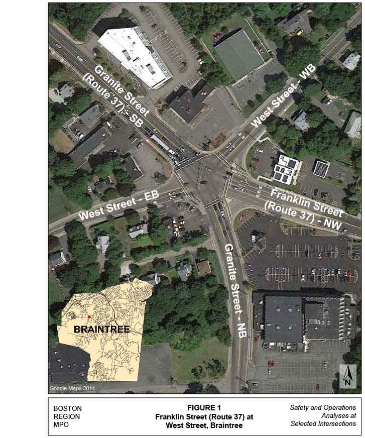
This memorandum summarizes safety and operations analyses and proposes improvement strategies for the intersection of Route 37 (Franklin and Granite streets) at West Street in Braintree. The intersection and its location are shown in Figure 1.
The location was approved for study by the Boston Region MPO following a selection process1 for four locations from a short list of 21 intersections based on five criteria, including a high EDPO (Equivalent Property Damage Only) crash rating, the number of pedestrian and bicycle crashes, transit significance, regional significance, and implementation potential.
The four locations approved for study are:
The Route 37 at West Street location was the only intersection in Braintree that met all five criteria in the intersection selection criteria process. One other intersection in Braintree was considered; however, it met only three of the selection criteria.
The memo contains the following sections:
It also includes technical appendices that contain methods and data applied in the study and detailed reports of the intersection capacity analyses.
Route 37, running primarily in the north–south direction through the entire town of Braintree, is a principal arterial that is owned by MassDOT and is located within MassDOT’s District 6 Highway Division region. It is named Granite Street north of the study intersection and has two lanes in each direction. South of the intersection it is named Franklin Street and has one lane in each direction. At the study intersection, Route 37 runs in a northwest–southeast direction.
Route 37 is intersected by West Street from the east and west; and Granite Street from the south. West Street, which has one lane in each direction, is a local town-owned roadway that runs primarily in an east–west direction through the study intersection. West of the intersection, West Street is classified as an urban principal arterial and east of the intersection the classification changes to urban minor arterial. Granite Street south of the intersection is also a town-owned roadway, which is classified as an urban principal arterial. It has one lane in each direction.
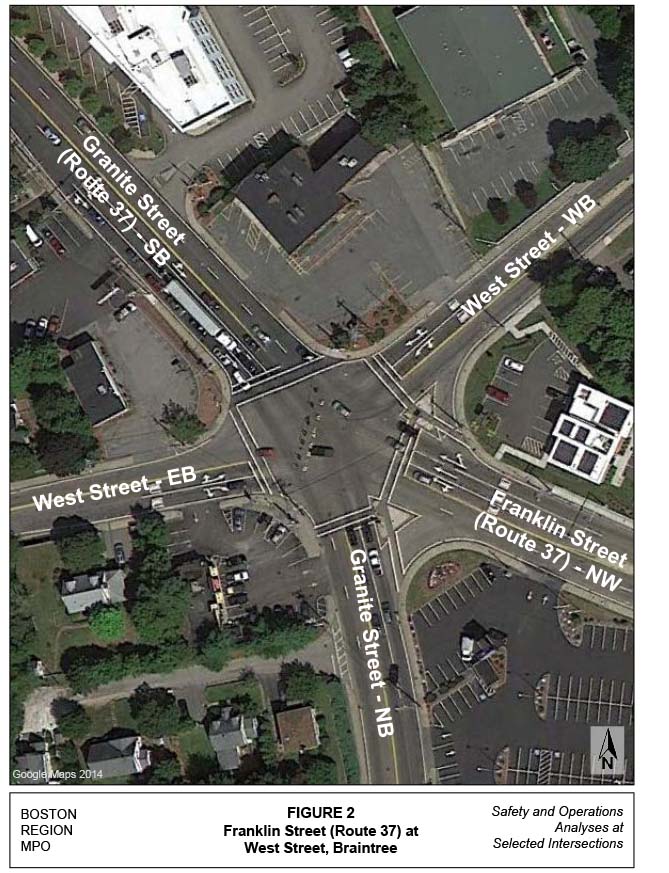
The intersection, Route 37 at West Street, is also known as the Five Corners. All the roadways approach the intersection at a skewed angle, as shown in Figure 2. The primary traffic flow through the intersection is along Route 37 and from Granite Street from the south.
The intersection is signalized, with multilane approaches on each approach leg. The Route 37 northwest approach widens to three lanes approximately 160 feet prior to the intersection. The left approach lane is marked for left turns to Granite and “through” movements to West Street westbound. The middle lane is marked for through movements to Route 37 northwest. The right lane is marked for through movements to Route 37 and right turns to West Street.
The Route 37 southbound approach also widens to three lanes before the intersection for approximately 215 feet. The left lane is marked for left turns to West Street and through movments to Route 37. The middle lane is marked as a shared through lane to both Route 37 (Franklin Street) southbound and Granite Street southbound. The right lane is marked as a shared lane for through movements to Granite Street and right turns to West Street.
The Granite Street northbound approach to the intersection widens to two lanes approximately 140 feet from the intersection. Both lanes are general purpose lanes and are unmarked. There is an unsignalized right-turn lane, seperated by a delta island; the roadway does not widen for this right-turn movement.
The West Street eastbound approach to the intersection widens to two lanes approximately 100 feet from the intersection. The left lane is marked as a left-turn lane to Route 37 northbound and through lane to West Street. The right lane is marked as a “through” lane to Franklin Street and a right-turn lane to Granite Street southbound.
The westbound West Street approach also widens to two lanes, approximatel 80 feet from the intersection. This approach is marked similiarly to the eastbound approach, with one lane providing access to Granite Street southbound and Franklin Street southbound; and the right lane providing access to West Street westbound and right turns to Route 37 northbound.
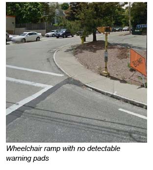
Pedestrian signals and crosswalks are provided on all intersection approaches. Two traffic islands for the exclusive right-turn lanes allow for shorter crosswalk lengths for pedestrians. Sidewalks (approximately six feet wide) are present along all five corners of the intersection and also along both sides of all of the approach streets. Wheelchair ramps are provided; however, several appear to not meet ADA requirements (see photo at the right). No provisions for bicycles have been provided.
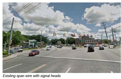
The signal heads, mounted on an overhead span wire (see photo below), include standard three-face signal heads, a five-face signal head, and a four-face signal head. No back plates are provided on any of the signal heads. The support poles for the span wire are located in the northeast and the southwest corners of the intersection. There are additional three-face signal heads mounted on the span wire poles and one lone post-mounted signal head located on the small delta island between Franklin Street and West Street in the southeast corner. The pedestrian heads are all pole-mounted or are also mounted on the span wire support poles. Pedestrian activation is provided.
The land use at the five corners of the intersection is zoned either General Business or Highway Business. The southern corner, between Granite and Franklin streets, contains the 400 Franklin Street office building, which includes several businesses and shops. The parking lots for this building are between Franklin and Granite streets, and on the south side of the building. The southeast corner, between Franklin and West streets, has a TD Bank. The northeast corner has a Citizens Bank and the northwest corner has the Vitamin Shoppe and Firestone Complete Auto Care garage. A Dunkin Donuts is located on the southwest corner. Away from the intersection, along Franklin Street, Granite Street to the south, and West Street, the zoning changes to residential. Only along the eastern side of Route 37, north of the intersection, does the zoning remain business.
There are two Massachusetts Bay Transportation Authority (MBTA) bus routes that travel through the intersection— MBTA bus Routes 236 and 238. The Route 236 travels between the South Shore Plaza and Quincy Center. The Route 238 travels between the Holbrook/Randolph Commuter rail station and Quincy Center. Both bus routes travel along Route 37 north of the intersection and then split, with the 238 traveling along Granite Street south of the intersection and the 236 traveling along Franklin Street.
The bus stops for both routes, north of the intersection, are located approximately 250 feet from the intersection, on either side of Route 37. The Route 236 bus stops on both sides of Granite Street are located approximately 150 feet south of the intersection and the stops for Route 238 are located approximately 250 feet south of the intersection, along Franklin Street. The bus stops require the MBTA buses to stop in the curb-side travel lane to let passengers on and off. During congested periods these stops could present a situation where side-swipe and rear-end accidents could occur.
Three major issues, which are related, were identified. First, the intersection has a high number of crashes; second, the intersection is highly congested during the AM and PM peak hours; and third, the intersection geometry is not ideal for a high-volume signalized intersection. In addition when there are traffic incidents or heavy delays on Route 93 and Route 3, Route 37 is used as a cut-through between those two highway facilities.
Based on the field observations and crash and traffic data analyses, the issues and concerns for the intersection can be summarized as:
Table 1 summarizes the crash statistics at the intersection based on the MassDOT Registry of Motor Vehicles (RMV) 2006–2010 crash data. On average, approximately 17 crashes occurred at the intersection each year. About 35 percent of the total crashes resulted in personal injuries. Crash types consist of 52 percent angle collisions, 19 percent rear-end collisions, 8 percent sideswipe collisions, 7 percent head-on collisions, 7 percent unknown types of collisions, and 5 percent single-vehicle collisions.
In the five-year period, there were no reported pedestrian crashes or bicycle crashes.
About 48 percent of the total crashes occurred during peak periods, which indicates that many of the crashes are potentially related to stop-and-go traffic conditions at the intersection during congested periods.
Crash rate2 is another effective tool for examining the relative safety of a location. Based on the crash data and the turning-movement counts collected recently by MPO staff, the crash rate for this intersection was calculated as 1.13 (see Appendix A). This is much higher than the average crash rate for signalized intersections in MassDOT Highway Division District 6, which is estimated to be 0.76.3
Table 1
Route 37 at West Street and Granite Street—Crash Summary
Crash Category |
2006 |
2007 |
2008 |
2009 |
2010 |
Total |
Average |
|---|---|---|---|---|---|---|---|
Crash severity |
Blank |
Blank |
Blank |
Blank |
Blank |
Blank |
Blank |
Property damage only |
19 |
8 |
9 |
4 |
9 |
49 |
9.8 |
Personal injury |
4 |
6 |
6 |
6 |
7 |
29 |
5.8 |
Fatality |
0 |
0 |
0 |
0 |
0 |
0 |
0.0 |
Collision type |
Blank |
Blank |
Blank |
Blank |
Blank |
Blank |
Blank |
Not reported |
4 |
2 |
0 |
0 |
0 |
6 |
1.2 |
Angle |
9 |
9 |
7 |
7 |
12 |
44 |
8.8 |
Rear-end |
4 |
4 |
3 |
2 |
3 |
16 |
3.2 |
Side-swipe |
2 |
2 |
3 |
0 |
0 |
7 |
1.4 |
Head-on |
2 |
0 |
1 |
1 |
2 |
6 |
1.2 |
Single-vehicle |
3 |
0 |
1 |
0 |
0 |
4 |
0.8 |
Roadway conditions |
Blank |
Blank |
Blank |
Blank |
Blank |
Blank |
Blank |
Not reported |
1 |
0 |
0 |
0 |
0 |
1 |
0.2 |
Wet or icy pavement |
8 |
5 |
5 |
3 |
5 |
26 |
5.2 |
Weather conditions |
Blank |
Blank |
Blank |
Blank |
Blank |
Blank |
Blank |
Dark/lighted |
4 |
6 |
3 |
2 |
3 |
18 |
3.6 |
Clear |
12 |
13 |
11 |
6 |
12 |
54 |
10.8 |
Cloudy |
4 |
1 |
0 |
1 |
0 |
6 |
1.2 |
Rain |
6 |
2 |
4 |
2 |
5 |
19 |
3.8 |
Snow |
1 |
1 |
1 |
1 |
0 |
4 |
0.8 |
Crashes during weekday peak periods1 |
15 |
5 |
5 |
5 |
10 |
40 |
8.0 |
Crashes involving pedestrian(s) |
0 |
0 |
0 |
0 |
0 |
0 |
0.0 |
Crashes involving bicyclist(s) |
0 |
0 |
0 |
0 |
0 |
0 |
0.0 |
Total crashes |
24 |
17 |
16 |
10 |
17 |
84 |
16.8 |
1 Peak periods are defined as 7:00–10:00 AM and 3:30–6:30 PM.
Staff collected turning-movement counts at the intersection on Wednesday, December 5, 2012. The data were recorded in 15-minute intervals during peak traffic periods in the morning, from 7:00 to 9:00, and in the evening, from 4:00 to 6:00.
The peak-hour traffic volumes in each of the two peak periods was then identified, and data on the associated turning movements and pedestrian crossings were used for the intersection’s capacity analysis.
Figure 3 shows the observed vehicular turning-movement counts in the AM and PM peak hours. The intersection carried about 3,310 vehicles in the AM peak , from 7:30 to 8:30, and about 3,650 vehicles in the PM peak hour, from 5:00 to 6:00 (see Appendix B for detailed 15-minute breakdowns for passenger vehicles, various heavy vehicles, pedestrians, and bicycles in the peak periods and the peak hours).
There were 14 and 8 pedestrians crossing the intersection during the AM and PM peak hours, respectively. The highest number of pedestrian crossings occurred on the southern section of the intersection, crossing Granite and Franklin streets. There were no bicyclist’s observed during the peak periods during the traffic counts.
Heavy vehicles accounted for about 3.8 percent of the total entry traffic in the AM peak hour and about 1.0 percent in the PM peak hour. The through movements on the northbound and southbound Granite Street approaches carry the highest percentage of heavy vehicle traffic at the intersection. However, based on observations made by the Town of Braintree planners, there is significant truck traffic during the off-peak hours, predominately a high number of FedEx vehicles using Granite Street south of the intersection.
Based on the counts, signal permit data, and manual traffic signal timing, the intersection was modeled as a fully actuated isolated intersection. Table 2 summarizes the Synchro4 analysis results for existing conditions in the AM and PM peak hours.
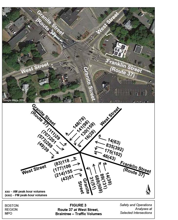
TABLE 2
Intersection Capacity Analysis, Existing Conditions
Street Name |
Approach/Movement |
LOS1 |
Delay per Vehicle |
|---|---|---|---|
Granite Street |
NB – All |
F (F) |
94.8 (142.5) |
Route 37 (Franklin) |
NW – Left/through |
F (F) |
609.7 (335.5) |
Route 37 (Franklin) |
NW – Through/right |
E (D) |
66.8 (37.1) |
Route 37 (Granite) |
SB – Left/through |
E (F) |
66.0 (169.5) |
Route 37 (Granite) |
SB – Through/right |
E (F) |
55.3 (147.5) |
West Street |
EB – Left/through |
F (F) |
499.3 (400.4) |
West Street |
EB – Through/right |
F (F) |
161.3 (167.3) |
West Street |
WB – Left/through |
F (F) |
289.6 (465.6) |
West Street |
WB – Through/right |
E (D) |
55.7 (42.2) |
Overall |
Blank |
F (F) |
162.8 (182.1) |
1 LOS = level of service. The LOS for the AM peak hour is the first letter. The LOS for the PM peak hour is in parentheses.
The analysis indicates that the intersection operates at a level of service (LOS) F in the AM peak hour with an average delay of over two minutes per vehicle. In the PM peak hour, the intersection is estimated to operate at LOS F with an average delay of nearly three minutes per vehicle. Under the existing conditions at the intersection, the Route 37 approaches operate primarily at LOS E during the AM peak period. However conditions get worse in the PM peak hour, with the additional afternoon traffic. Detailed analysis parameters and results for the AM and PM peak hours are in Appendix C.
The intersection’s signal equipment has been updated fairly recently, and the very limited ability to widen any approaches or departures limits the options for improving the current operations at the intersection. MPO staff tested a number of alternatives with signal timing improvements, lane assignments, and additional approach lanes, specifically adding a lane on Route 37. However the impacts to adjacent businesses, including their parking, would be significant, and the resulting operational improvements would not result in significant benefits. Also it should be noted that any changes to existing lane assignments would necessitate widening of the departure lanes. Staff also examined the possibility of replacing the current signalized intersection with a modern roundabout.
To simplify the analysis, one alternative was examined with signal timing changes and one alternative was evaluated for the potential of constructing a modern roundabout. The two alternatives are:
Tables 3 and 4 summarize the capacity analyses for Alternative 1 (signal timing improvements) in both the AM and PM peak hours, and compares A with the existing conditions. Figure 5 shows the existing and proposed signal timings and phasing for the intersection and Table 5 provides a description of the movements and phases.
TABLE 3
Intersection Capacity Analysis of Level-of-Service for
Existing Conditions and Alternatives
Blank |
Blank |
Existing Conditions |
Alternative 1 |
|---|---|---|---|
Street Name |
Approach |
LOS1 |
LOS |
Granite Street |
NB – All |
F (F) |
F (F) |
Route 37 (Franklin) |
NW – Left/through |
F (F) |
F (F) |
Route 37 (Franklin) |
NW – Through/right |
E (D) |
E (C) |
Route 37 (Granite) |
SB – Left/through |
E (F) |
F (D |
Route 37 (Granite) |
SB – Through/right |
E (F) |
E (D) |
West Street |
EB – Left/through |
F (F) |
F (F) |
West Street |
EB – Through/right |
F (F) |
F (F) |
West Street |
WB – Left/through |
F (F) |
F (F) |
West Street |
WB – Through/right |
E (D) |
C (C) |
Overall |
Blank |
F (F) |
F (F) |
1 LOS = level of service. The LOS for the AM peak hour is the first letter. The LOS for the PM peak hour is in parentheses.
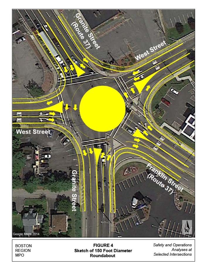
TABLE 4
Intersection Capacity Analysis of Delay for
Existing Conditions and Alternatives
Blank |
Blank |
Existing Conditions |
Alternative 1 |
|---|---|---|---|
Street Name |
Approach |
Delay1 |
Delay |
Granite Street |
NB – All |
94.8 (142.5) |
128.3 (183.2) |
Route 37 (Franklin) |
NW – Left/through |
609.7 (335.5) |
189.9 (976.7) |
Route 37 (Franklin) |
NW – Through/right |
66.8 (37.1) |
57.2 (27.1) |
Route 37 (Granite) |
SB – Left/through |
66.0 (169.5) |
117.6 (49.0) |
Route 37 (Granite) |
SB – Through/right |
55.3 (147.5) |
62.3 (36.1) |
West Street |
EB – Left/through |
499.3 (400.4) |
259.7 (695.9) |
West Street |
EB – Through/right |
161.3 (167.3) |
108.8 (318.9) |
West Street |
WB – Left/through |
289.6 (465.6) |
257.5 (559.9) |
West Street |
WB – Through/right |
55.7 (42.2) |
27.7 (27.6) |
Overall |
Blank |
162.8 (182.1) |
115.3 (217.6) |
1 The delay for the AM peak hour is the first number. The delay for the PM peak hour is in parentheses.
FIGURE 5
Intersection Signal Timings and Phasing for the
Existing Conditions and Alternatives
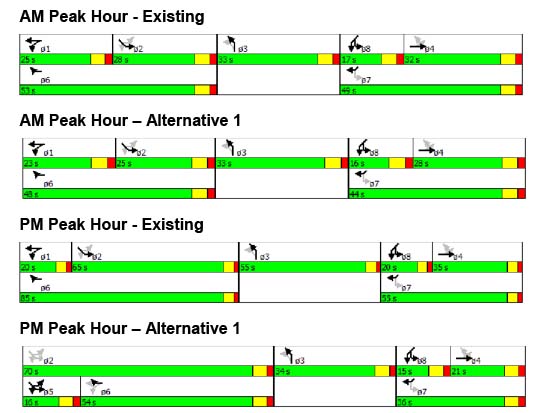
TABLE 5
Intersection Signal Phasing for
Existing Conditions and Alternatives
Blank |
Blank |
Existing Conditions |
Alternative 1 |
|---|---|---|---|
Street Name |
Approach |
Phases |
Phases |
Granite Street |
NB – All |
3 |
3 |
Route 37 (Franklin) |
NW – Left |
1 |
1 |
Route 37 (Franklin) |
NW – Through/right |
6 |
6 |
Route 37 (Granite) |
SB – All |
2 |
2 |
West Street |
EB – All |
4 |
4 |
West Street |
WB – Left/through |
8 |
8 |
West Street |
WB – Through/right |
7 |
7 |
Alternative 1, retiming the signal with the existing geometry, resulted in the same overall level of service, LOS F, during both the AM and PM peak hours. However the overall delay improved by 37 seconds in the AM peak hour. In the PM peak, while some individual movements improved, the overall delay increased slightly.
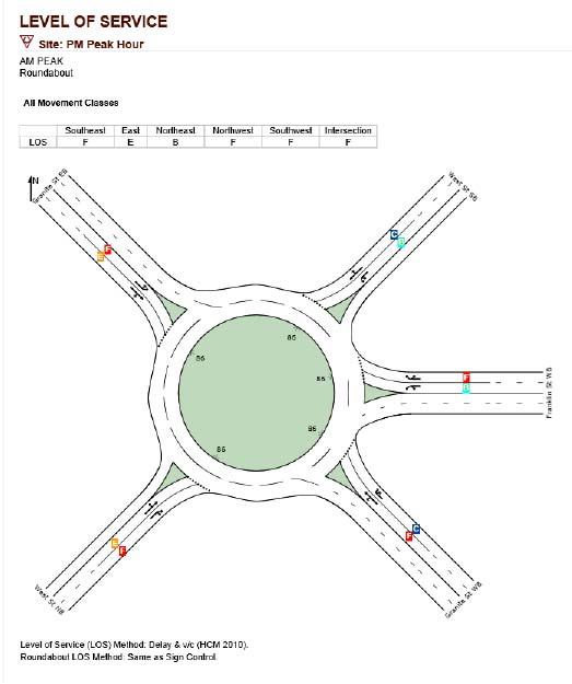
Alternative 2, replacing the existing signalized intersection with a modern roundabout, was evaluated with the Massachusetts Roundabout Installation Screening Form. The evaluation examines safety, operations, traffic calming, aesthetics and community enhancements, and access management factors. The evaluation determined that a roundabout is not recommended for this location because its high traffic volumes would require a multilane roundabout, and there is inadequate space at that location for a roundabout. The evaluation form is included in Appendix D.
The alternative was also evaluated with SIDRA software6 to determine the operations of a roundabout at that location with the existing traffic volumes. The figures below show the results of the analysis. As shown in the figures, the two-lane roundabout would operate overall at LOS F during both peak hours. Multiple legs of the roundabout would also have failing operations. Detailed analysis parameters and results for the AM and PM peak hour are included in Appendix E.
Between the results of the evaluation and the operations analysis, a two-lane roundabout is not recommended for this location. The sketch of the two-lane roundabout shows a minimum diameter of 150 feet. At this location, with the approach angles of the existing roadways, a larger-diameter roundabout would be necessary. This would cause a greater impact to neighboring property owners.
FIGURE 6
SIDRA Analysis Results for a Two-Lane Roundabout:
AM Peak Hour
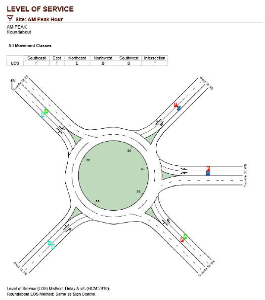
FIGURE 7
SIDRA Analysis Results for a Two-Lane Roundabout:
PM Peak Hour
The study intersection has a high number of crashes and is very congested during the peak hours. The above analyses indicate that many crashes are possibly related to the congested conditions at the intersection and the complicated turning movements caused by a five-legged skewed intersection.
Nevertheless, the congestion at the intersection is not easy to totally mitigate at any given approach without impacting one of the other approaches, and because of the very constrained right-of-way. Because of these limitations, staff recommends a comprehensive approach of minor improvements to the intersection to improve safety and operations.
The intersection improvements should include the following:
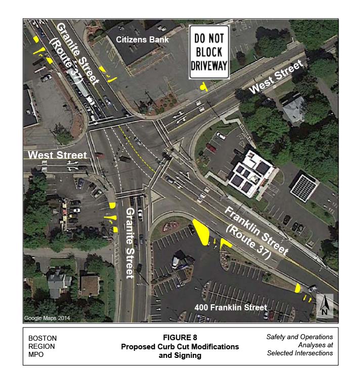
FIGURE 9
MUTCD Sign R10-15: Turning Vehicles Yield to Pedestrians
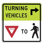
All of the improvements recommended above, except for the wheelchair ramp reconstruction, can be considered low-cost, short-term improvements. These improvements should improve operations and safety at the intersection not only for motor vehicles, but also for pedestrians and bicyclists.
MSA/msa
1 Mark Abbott and Chen-Yuan Wang, memorandum to Boston Region MPO, “Safety and Operations Analyses at Selected Intersections—FFY 2013, Task 1: Intersection Selection Procedure,” November 1, 2012
2 Crash rates are estimated based on crash frequency (crashes per year) and vehicle exposure (traffic volumes or miles traveled). Per MassDOT guidance, crash rates are expressed as “crashes per million entering vehicles” for intersection locations and as “crashes per million miles traveled” for roadway segments.
3 The average crash rates estimated by the MassDOT Highway Division (as of January 23, 2013) are based on a database that contains intersection crash rates submitted to MassDOT as part of the review process for an Environmental Impact Report or Functional Design Report.
4 Synchro Version 8 is developed and distributed by Trafficware Ltd. The software can perform capacity analysis and traffic simulation (when combined with SimTraffic) for an individual intersection or a series of intersections.
5National Cooperative Highway Research Program, NCHRP Report 672: Roundabouts: An Informational Guide, Second Edition, Transportation Research Board, 2010.
6 SIDRA Intersection 6.0.20.4660, © 2000-2014, Akcelik and Associates Pty. Ltd.
APPENDIX A. Crash Rate Worksheet. Crash rates for the intersection are shown on MassDOT’s Intersection Crash Rate worksheet.
APPENDIX B. Turning-Movement Count Data. Two pages of tables showing results of counts of “all vehicles” for the AM peak hour, the AM peak period, the PM peak hour, and the PM peak period.
APPENDIX C. Synchro Analysis. Tables of data (24 pages) generated by the Synchro 8 analysis of the intersection under various conditions.