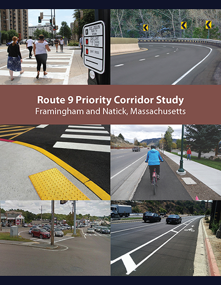
Route 9 Priority Corridor Study
Framingham and Natick, Massachusetts
Executive Summary
Chapter 1—Introduction
Chapter 2— Study Location and Process
Chapter 3—Roadway Characteristics
Chapter 4—Data Collection
Chapter 5—Existing Conditions
Chapter 6—Improvements
Chapter 7—Conclusion and Next Steps
Project Manager
Seth Asante
Project Principal
Mark Abbott
Data Analysts
Kathy Jacob
Julie Dombroski
Graphics
Kenneth Dumas
Cover Design
Kim DeLauri
Editor
David Davenport
The preparation of this document was supported
by Federal Highway Administration through
MPO Combined PL and 5303 #112310 and
MPO Combined PL and 5303 #114674.
Central Transportation Planning Staff is
directed by the Boston Region Metropolitan
Planning Organization (MPO). The MPO is composed of
state and regional agencies and authorities, and
local governments.
July 2022
For general inquiries, contact
Central Transportation Planning Staff
State Transportation Building
Ten Park Plaza, Suite 2150
Boston, Massachusetts 02116
857.702.3700
The Boston Region Metropolitan Planning Organization (MPO) operates its programs, services, and activities in compliance with federal nondiscrimination laws including Title VI of the Civil Rights Act of 1964 (Title VI), the Civil Rights Restoration Act of 1987, and related statutes and regulations. Title VI prohibits discrimination in federally assisted programs and requires that no person in the United States of America shall, on the grounds of race, color, or national origin (including limited English proficiency), be excluded from participation in, denied the benefits of, or be otherwise subjected to discrimination under any program or activity that receives federal assistance. Related federal nondiscrimination laws administered by the Federal Highway Administration, Federal Transit Administration, or both, prohibit discrimination on the basis of age, sex, and disability. The Boston Region MPO considers these protected populations in its Title VI Programs, consistent with federal interpretation and administration. In addition, the Boston Region MPO provides meaningful access to its programs, services, and activities to individuals with limited English proficiency, in compliance with U.S. Department of Transportation policy and guidance on federal Executive Order 13166.
The Boston Region MPO also complies with the Massachusetts Public Accommodation Law, M.G.L. c 272 sections 92a, 98, 98a, which prohibits making any distinction, discrimination, or restriction in admission to, or treatment in a place of public accommodation based on race, color, religious creed, national origin, sex, sexual orientation, disability, or ancestry. Likewise, the Boston Region MPO complies with the Governor's Executive Order 526, section 4, which requires that all programs, activities, and services provided, performed, licensed, chartered, funded, regulated, or contracted for by the state shall be conducted without unlawful discrimination based on race, color, age, gender, ethnicity, sexual orientation, gender identity or expression, religion, creed, ancestry, national origin, disability, veteran's status (including Vietnam-era veterans), or background.
A complaint form and additional information can be obtained by contacting the MPO or at http://www.bostonmpo.org/mpo_non_discrimination. To request this information in a different language or in an accessible format, please contact
Title VI Specialist
Boston Region MPO
10 Park Plaza, Suite 2150
Boston, MA 02116
civilrights@ctps.org
By Telephone:
857.702.3702 (voice)
For people with hearing or speaking difficulties, connect through the state MassRelay service:
Relay Using TTY or Hearing Carry-over: 800.439.2370
Relay Using Voice Carry-over: 866.887.6619
Relay Using Text to Speech: 866.645.9870
For more information, including numbers for Spanish speakers, visit https://www.mass.gov/massrelay
The Route 9 Priority Corridor Study focuses on one of the locations identified in the Needs Assessment for Destination 2040, the Metropolitan Planning Organization’s (MPO) Long-Range Transportation Plan (LRTP) endorsed in 2019. The LRTP is used to guide investment decisions regarding transportation infrastructure improvements in the Boston region. The MPO prioritized Route 9 in Framingham and Natick for study after considering a number of factors: the need to address poor safety conditions and traffic congestion; the desire to enhance multimodal transportation; and the potential for recommendations from the study to be implemented. This report details the existing conditions, assesses safety and operational problems, discusses options for improvements, and makes recommendations for implementing improvements. The recommendations, if implemented, would transform the roadway into a more pedestrian- and bicyclist-friendly roadway, improve safety at high-crash locations, make traffic flow and operations efficient, support local businesses, and promote multimodal transportation.
The Boston Region Metropolitan Planning Organization (MPO) selected Route 9 in Framingham and Natick as the subject of a corridor study in federal fiscal year 2021. The study focused on one of the locations identified in the Needs Assessment for the MPO’s Long-Range Transportation Plan, Destination 2040. The location was prioritized for study after considering a number of factors, including the need to address poor safety conditions and traffic congestion; desire to enhance multimodal transportation; need to maintain regional travel capacity; and the potential to implement the study recommendations. This report analyzes the existing conditions, assesses safety and operational problems, and develops improvements.
Route 9 in Framingham and Natick is a two-way, four-lane principal arterial under the jurisdiction of the Massachusetts Department of Transportation (MassDOT). A series of maps are included in this report. The maps in Figures 1 and 2 show the study area and the study intersections. Because of the long corridor (approximately nine miles) the study was focused on improving safety, operations, and multimodal transportation at key locations along the corridor. MassDOT Highway Division and MPO staff collected and assembled the data used to assess the existing conditions and identify problems in the corridor. The data included vehicular, pedestrian, and bicycle volumes; traffic speeds; and crashes.
Key concerns for people walking include poor accommodations such as crossing safety issues, poor sidewalk conditions, lack of pedestrian activated signals and pushbuttons on side streets, limited safe crossing opportunities, long crosswalks without refuge areas, gaps in the sidewalk network, insufficient crossing times, and curb ramps that are not compliant with the Americans with Disabilities Act (ADA).
Key concerns for people biking include, but are not limited to, lack of safe biking facilities such as separated bike lanes, high volumes and speeds of vehicles, crashes involving people biking, and lack of awareness for people biking. Although there are bikeable shoulders on Route 9, they are not marked as bike lanes, are of inconsistent width, and end at the signalized intersection where the shoulders are used as turn lanes. In addition, there is a considerable variation in posted speed limits throughout the corridor (40 miles per hour [mph] to 50 mph) that results in increased stress levels for people biking.
A key concern for people driving in the corridor is the greater-than-expected number of crashes: three intersections are on the list of the Top 200 high-crash locations in Massachusetts and eight intersections (including the three top 200 high-crash locations) are on the list of Highway Safety Improvement Program (HSIP) crash clusters. 1 For many of the crashes, the contributory factors include lack of advance intersection lane control signs, pavement markings, yellow retroreflective borders on signal head backplates, and inadequate street lighting leading to high number of nighttime crashes. Additional contributory factors are short acceleration and deceleration lanes, horizontal and vertical curves that limit sight distances, and lack of advance notifications. In addition, human factors such as failure to yield, inattention or distraction, following too closely, ignoring traffic control regulations, and other aggressive driving behaviors contributed to the high number of crashes.
People riding the bus are also presented with challenges in the corridor, which in many ways are similar to those walking or biking listed above. Additional challenges for bus operations and riders include lack of safe bus stops on Route 9 as several major intersections lack space for dedicated bus stops. In addition, congestion effects travel time and on-time performance of the buses as the corridor lacks transit signal priority equipment.
MPO staff, working with an advisory task force (representatives from MassDOT, the City of Framingham, and Town of Natick) developed short- and long-term improvement for the corridor.
The short-term improvements are typically low cost, relatively uncomplicated and inexpensive to implement, require minimal design efforts, and typically take fewer than five years to implement. These improvements can be included in MassDOT projects and in corridor or maintenance activities. They include upgrading sidewalks and curb ramps to MassDOT standards and ADA-compliance; adding countdown timers to help expedite pedestrian crossings; painting high visibility crosswalks; adding new or repainting pavement markings; upgrading signs and advance notifications; and repairing poor sidewalks. Additional short-term improvements include retiming signals to reduce congestion, modifying change and clearance intervals to MassDOT standards, and adding retroreflective backplates with yellow borders to the signal heads to make them more visible to motorists.
The long-term improvements, generally high cost, require more design and engineering efforts and more funding resources. These improvements would focus on modernizing the roadway to make it safer and multimodal. They include reconstructing intersections, closing gaps and upgrading sidewalk network, adding separated bike lanes, and upgrading signal equipment. Additional long-term improvements include constructing new at-grade or grade-separated crossings for people walking and biking, upgrading emergency vehicle preemption systems, improving bus transit accommodations at selected locations, and installing bus transit priority signal systems.
The concepts developed in this study provide MassDOT, the City of Framingham, the Town of Natick, and other stakeholders an opportunity to review the improvements for addressing deficiencies in the corridor before committing design and engineering funds to a roadway improvement project. This document provides a guide for possible improvements on this roadway; however, MassDOT, the City of Framingham, and the Town of Natick are not obligated to make these improvements. If implemented, the proposed improvements offered in this report would increase traffic safety, make traffic operations more efficient, and modernize the roadway to accommodate all users. The study aligns with the Boston Region MPO’s goals of increasing safety on the region’s highway system; modernizing roadways to improve capacity and mobility by expanding the quantity and quality of walking and bicycling infrastructure; making transit service more efficient; reducing congestion; and preserving the transportation system.
The Boston Region Metropolitan Planning Organization (MPO) has been conducting studies of roadway corridors identified through the Needs Assessment of the Long-Range Transportation Plan (LRTP) as needing infrastructure improvements to address safety, mobility, and traffic operations problems.2 Municipalities in the region and the Massachusetts Department of Transportation (MassDOT) have been receptive to these studies, which provide the opportunity to review conceptual options to improve a specific arterial segment before committing design and engineering funds to a project. If a proponent initiates a project that qualifies for state and federal funds, the study’s documentation may be useful to both MassDOT and the project proponent for completing MassDOT Highway Division’s project initiation forms, identifying problems along the corridor, justifying the need for improvements, and providing improvement concepts to advance into the preliminary design and engineering stages.
MPO staff identified a number of arterial roadway segments listed in the LRTP that should be prioritized because the roadways require maintenance, modernization, and safety and mobility improvements. To address the problems that exist in some of these arterial segments, a LRTP priority corridor study was included in the federal fiscal year (FFY) 2021 Unified Planning Work Program (UPWP). 3 Staff selected Route 9 in the City of Framingham and the Town of Natick as the subject of the priority corridor study. MPO staff selects locations for study (considering agency, municipal, subregional, and other public feedback) and collects data, conducts technical analysis, and recommends improvements. Recommendations from the study are sent to implementing agencies, which may choose to fund improvements through various federal, state, and local sources, separately or in combination.
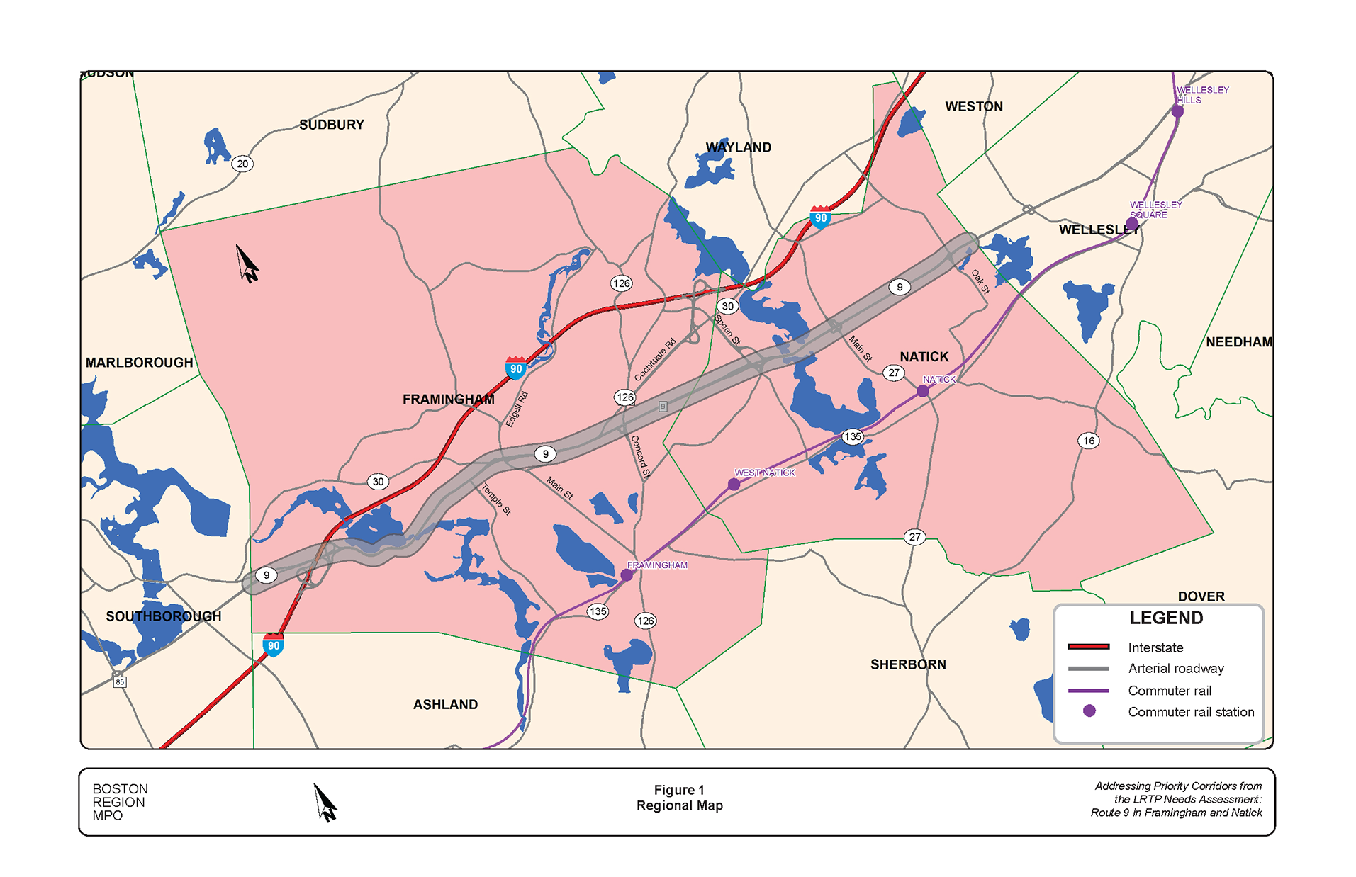
On November 7, 2020, the Boston Region Metropolitan Planning Organization (MPO) identified Route 9 in the City of Framingham and the Town of Natick for study, following a selection process that involved a review of safety conditions, congestion, multimodal and regional significance of the roadway, regional equity, and the potential for implementing study recommendations.4 ,5 ,6 ,7 ,8 ,9 Figure 1 shows the study corridor and the surrounding area.
The study location was selected from a list of 44 arterial segments in 37 municipalities in the Boston Region MPO area.10 A copy of the technical memorandum describing the selection process is included in Appendix A. Massachusetts Department of Transportation (MassDOT) Highway Division District 3, the MassDOT Office of Transportation Planning, the City of Framingham, and the Town of Natick supported the study of Route 9 by collecting data needed for the analyses, reviewing documentation of existing conditions, identifying problems, and developing improvements to mitigate the problems.
Figure 1
Regional Map
MassDOT, the City of Framingham, and the Town of Natick have shown a commitment to improving conditions to transform this car-centric corridor into a route for everyone by
Toward that end, the objectives of this study were to
Stakeholder participation is a crucial part of any study. Hence, MPO staff used a number of methods to engage stakeholders in planning for improvements to Route 9. An advisory task force composed of representatives from Framingham, Natick, MassDOT, and MetroWest Regional Transit Authority was established to guide this study. MPO staff met with the task force to discuss existing problems and proposed improvements. MPO staff also participated in Road Safety Audits that were conducted for the corridor. This report reflects the task force’s feedback as well as the safety audits members’ feedback. Appendix A includes a list of task force members and comments.
Route 9 in Framingham and Natick is a state highway. It is classified as an urban principal arterial and part of the National Highway System (NHS) program. The nine-mile-long corridor assumes the local road names of Worcester Road in Framingham and Worcester Street in Natick. It is a four-lane, two-way roadway that widens at the signalized intersections to accommodate turn lanes. Route 9 has no access control and open to all traffic including trucks. The roadway’s right-of-way width varies between 85 feet and 105 feet, with the wider sections on the segment at the Framingham and Natick lines in the vicinity of the Shoppers’ World and Natick Mall. This roadway serves regional and local traffic, carrying between 40,000 and 60,000 vehicles per day. The posted speed limit varies from 40 miles per hour (mph) to 50 mph throughout the corridor. Segments of roadway have different characteristics and contexts that define needs along the corridor as Route 9 serves uses including residential, recreational, educational, industrial and office parks, commercial, and open spaces. The corridor includes several MPO transportation equity zones such as low-income, minority populations, carless household, and low-English proficiency.
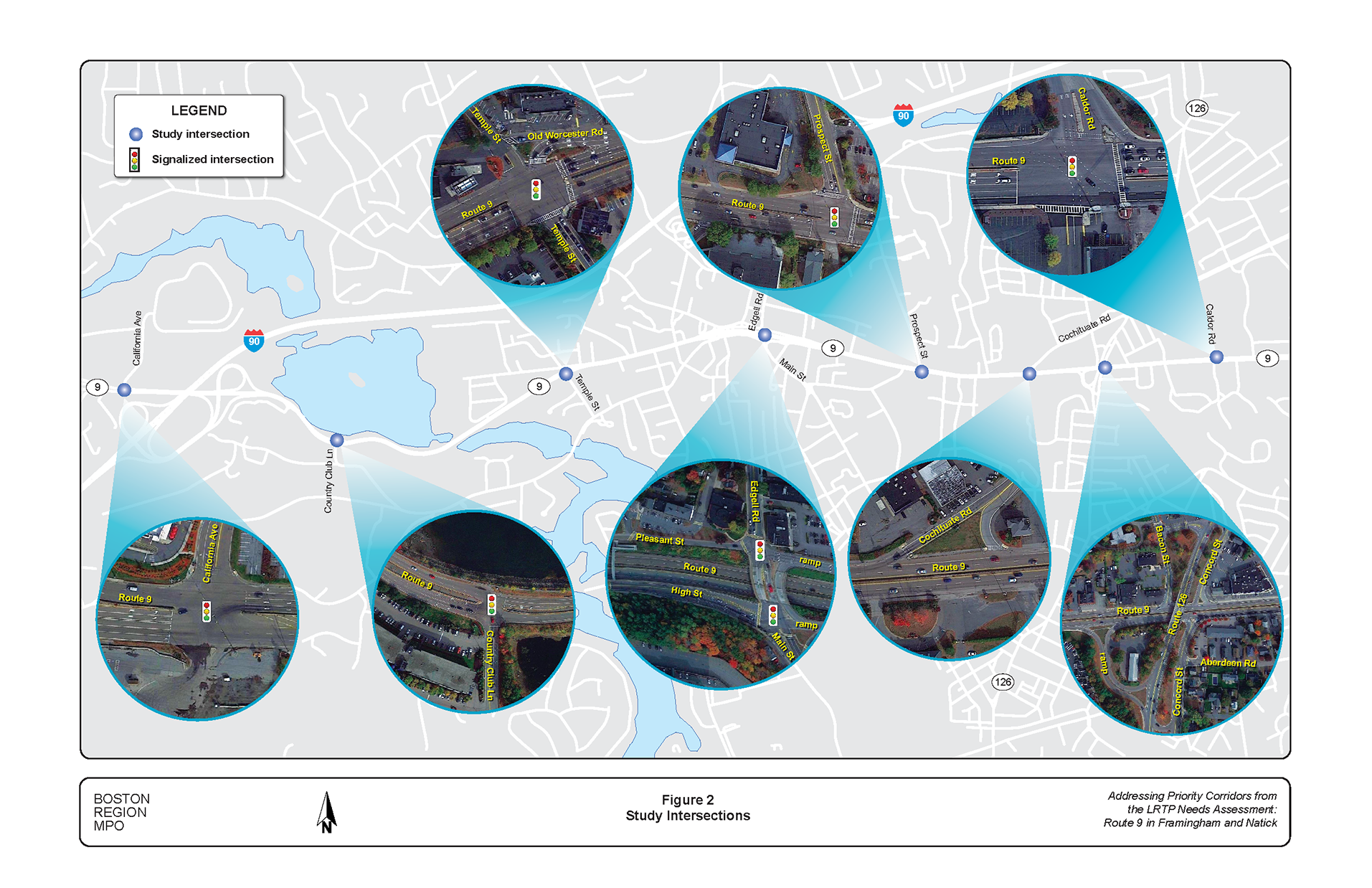
Figure 2 shows the major streets intersecting Route 9 that were included in the study. They serve the mix of land uses in the corridor. These intersecting streets include major and minor arterials and collector roadways that connect to downtown and commercial areas, industrial and office parks, educational centers, and neighborhoods in Framingham and Natick. The following describes the intersecting streets of the major intersections included in the study.
California Avenue is located west of the study area. It is a two-lane, two-way street with one lane in each direction and widens at its approach to Route 9 to accommodate turn lanes. California Avenue is a city-owned street with a posted speed limit of 25 mph and is open to all traffic. It is classified as a local street and provides access to the Framingham industrial and office park, which houses companies such Sanofi, Bose, and Genzyme. It has a six-foot sidewalk on the west side and street lights.
Figure 2
Study Intersections
Country Club Lane is located 0.9 miles east of California Avenue. It is a two-lane, two-way street with one lane in each direction and widens at its approach to Route 9 to accommodate turn lanes. Country Club Lane is a city-owned street with a posted speed limit of 25 mph and is open to all traffic. It is classified as an urban collector. It provides access to the Halstead Framingham Apartments and connects to Gates Street serving residential neighborhoods and the Framingham Country Club. There is no sidewalk on Country Club Lane, and it lacks street lights.
Temple Street is approximately one mile east of Country Club Lane. It is a two-lane, two-way street with one lane in each direction and widens at its approach to Route 9 to accommodate a northbound left-turn lane. Temple Street is a city-owned street with a posted speed limit of 25 mph and is open to all traffic. It is classified as an urban collector and provides access to the commercial area at its intersection with Route 9. In addition, it connects to Route 30, Salem End Road, and Old Worcester Road, all serving residential neighborhoods in Framingham. There is a sidewalk on the east side of Temple Street and street lights are present on the street.
Maynard Road is approximately 0.4 miles east of Temple Street. It is a two-lane, two-way street with one lane in each direction. Maynard Road is a city-owned street with a posted speed limit of 25 mph and is open to all traffic. It is classified as a local road and provides access to residential areas north and south of Route 9. Through movements are prohibited at the intersections because of the median on Route 9 and only right-turn-in and right-turn-out are allowed. Maynard Road north of Route 9 connects to Route 30 and serves residential neighborhoods. South of Route 9, Maynard Road connects to the Framingham State University and Salem End Road. There are sidewalks on either side of Maynard Road north of Route 9 but none on the portion south of Route 9. Street lights are present on Maynard Road.
Main Street and Edgell Road is approximately 0.4 miles east of Maynard Road. Both streets are two-lane, two-way streets with one lane in each direction, and widen at their approaches to Route 9 to accommodate turn lanes. Main Street and Edgell Road are grade-separated over Route 9 in the vicinity of the Route 9 interchange. They are city-owned streets with posted speed limit of 30 mph and are open to all traffic. Both are classified as urban minor arterials and provide access to the Framingham State University, Framingham Centre Common Historic District, and commercial and residential areas north and south of Route 9. They carry between 15,600 and 19,000 vehicles per day. There are sidewalks on either side of Main Street and Edgell Road and both have street lights.
Prospect Street is approximately 0.65 miles east of the Main Street/Edgell Road. It is a two-lane, two-way street with one lane in each direction and widens at its approach to Route 9 to accommodate southbound left-turn and right-turn lanes. Prospect Street is a city-owned street with a posted speed limit of 30 mph and is open to all traffic. It is classified as an urban collector and serves residential areas north of Route 9 in Framingham. There is a sidewalk on the east side of Prospect Street and street lights are present on the street.
Cochituate Road is approximately 0.4 miles east of Prospect Street. It is a two-lane, two-way street with one lane in each direction. Cochituate Road is a city-owned street with posted speed limit of 30 mph and is open to all traffic. It is classified as an urban minor arterial and connects to the commercial areas in Framingham and Natick. There are sidewalks on either side of Cochituate Road and street lights are present on the street.
Concord Street is grade-separated over Route 9 and just 0.2 miles east of the Cochituate Road. It is a two-lane, two-way street with one lane in each direction. Concord Street is a city-owned street with a posted speed limit of 30 mph and is open to all traffic. It is classified as an urban principal arterial, part of the NHS, and connects several Framingham neighborhoods including the Downtown and Framingham Commuter Rail Station. Concord Street carries about 19,600 vehicles per day in both directions. There are sidewalks on either side of Concord Street and street lights are present on the street.
Caldor Road is 0.5 miles east of the Concord Street. It is a two-lane, two-way street with one lane in each direction. Caldor Road is a privately owned local street that serves the Shoppers World commercial area. It is posted with a 15-mph speed limit and is open to all traffic. There is a sidewalk on the east side Caldor Road and street lights are present on the street.
Speen Street is grade separated over Route 9. In the vicinity of Route 9, it is four-lane, two-way divided roadway. It is a town-owned street; however, the ramps and overpasses are under Massachusetts Department of Transportation (MassDOT) jurisdiction. Speen Street is classified as minor arterial with a posted speed limit of 25 mph. It is a town-owned street; however, the ramps and overpasses are under MassDOT jurisdiction. There are sidewalks on both sides of the street and street lights are present on the street.
Oak Street is 3.5 miles east of the Caldor Road. It is a two-lane, two-way street with one lane in each direction. Oak Street is a city-owned street with a posted speed limit of 30 mph and is open to all traffic. It is classified as an urban minor arterial and serves residential neighborhoods in Natick. Oak Street carries about 19,600 vehicles per day in both directions. South of Route 9, Oak Street has a sidewalk only on the east side. North of Route 9, Oak Street has sidewalks on either side of the street. Street lights are present on the street.
Several cross streets and driveways intersect Route 9 as mentioned in the previous section, which creates safety and operations issues for users. Figure 2 shows the eight intersections identified in the Framingham segment with safety and operations problems and included for assessments. Chapters 5 and 6 include figures of the intersections showing the problems and proposed improvements, respectively. The following section describes the geometry, traffic and control, and land uses surrounding the signalized intersections. All of the intersections on Route 9 in the study area are under the jurisdiction of Massachusetts Department of Transportation.
California Avenue intersects Route 9 to form a four-leg signalized intersection. At the intersection, Route 9 eastbound approach has five travel lanes, two left-turn lanes, two through lanes, and a share through/right lane, while the westbound approach has four lanes, three through lanes and an exclusive right-turn lane. California Avenue southbound approach has three lanes, an exclusive left-turn lane, a shared left/through lane, and an exclusive right-turn lane. The driveway to the Route 9 East park-and-ride lot located south of the intersection, has two lanes on the approach, exclusive left-turn and right-turn lanes. The posted speed limits on Route 9 in the vicinity are 50 mph westbound and 45 mph eastbound and 25 mph on California Avenue. Sidewalk is present on the north side of Route 9 with a crosswalk across California Avenue. The intersection is equipped with a fully actuated and isolated traffic signal with bicycle detection. The signal heads are mounted on span wires with backplates and no retroreflective yellow borders. There are street lights installed on the California Avenue and the driveway to the park-and-ride lot but not on Route 9. The MetroWest Regional Transit Authority serves the park-and-ride lot and the industrial and office park north of the intersection.
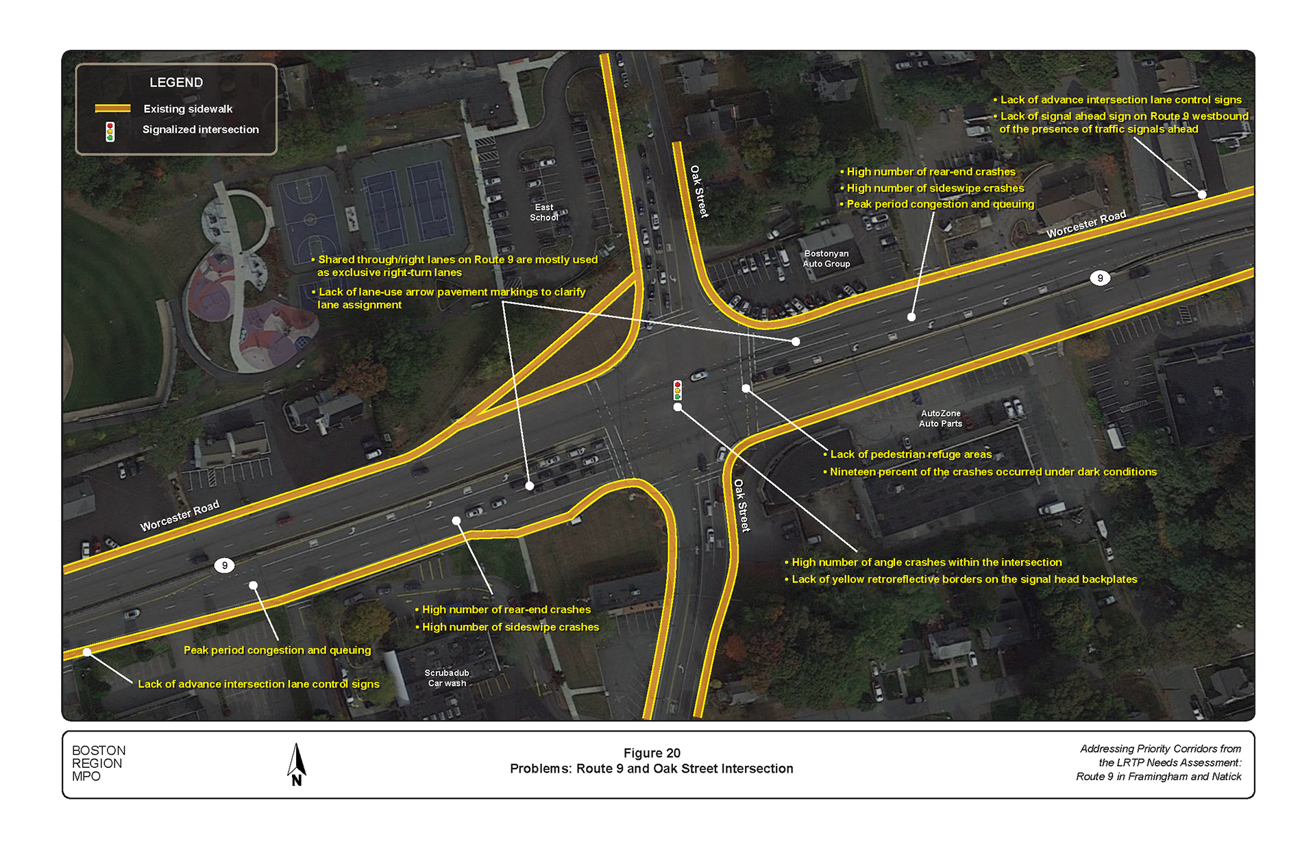
Country Club Lane intersects Route 9 to form a three-leg signalized intersection. It is located on a horizontal and vertical curve. The Foss Reservoir is located to the north of the intersection and the Halstead Framingham Apartments to the south. Each approach on Route 9 has two through lanes. In addition, the eastbound approach has an exclusive U-turn lane and right-turn lane while the westbound approach has an exclusive left-turn/U-turn lane. Country Club Lane has two lanes on the approach, an exclusive left-turn lane and a shared left-turn/right-turn lane at the approach. The intersection has a fully actuated and isolated traffic signal with bicycle detection. The signal heads are a mixture of mast arm and post mounts and have backplates without retroreflective yellow borders. Street lights are installed on the Country Club Lane but not on Route 9. There is a sidewalk on the north side of Route 9 but not on the south side.
Temple Street intersects Route 9 to form a five-leg signalized intersection. The intersection is located in a busy commercial area that includes Stop & Shop, Bank of America, CVS Pharmacy, Gulf Service Station, and McDonald’s. At the intersection, Route 9 eastbound approach has two through lanes and exclusive left-turn and right-turn lanes. On the westbound approach of Route 9, there are three through lanes. All turns on the westbound approach must turn right onto Old Worcester Road to make a left turn/U-turn or continue onto Old Worcester or Temple Street northbound. Temple Street northbound approach has two travel lanes, an exclusive left-turn lane and a shared through/right-turn lane while the southbound approach has one lane serving all movements. The intersection is equipped with a fully actuated and isolated traffic signal system. The signal heads are a mixture of span wire, mast arm, and post mounts, and have backplates without retroreflective yellow borders. Crosswalks with wheelchair ramps with detectable warning plates are present on the east leg of Route 9, south leg of Temple Street, and east leg of Old Worcester Road. Some street lights are present on Temple Street and Route 9.
Main Street and Edgell Road intersect with the Route 9 ramps and High Street to form two closely space signalized intersections. Edgell Road and Route 9 westbound on-and-off ramps intersection is located north of Route 9. Edgell Road has two lanes on the southbound approach, a through lane and a shared through/right-turn lane, while the northbound approach has exclusive left-turn and through lanes. Route 9 westbound off-ramp has three lanes, two exclusive left-turn lanes, and a shared through/right-turn lane.
Edgell Road, Main Street, High Street, and Route 9 on-ramp is located south of Route 9. Edgell Road southbound approach and Main Street northbound approach each has two lanes, a shared left-turn/through lane, and a shared through/right-turn lane. High Street eastbound approach has three lanes, exclusive left-turn lane, shared left-turn/through lane, and exclusive right-turn lane.
The two intersections are equipped with a fully actuated and interconnected signal system that operates as a clustered intersection. The signal heads are a mixture of mast arm and post mounts and have backplates without retroreflective yellow borders. Crosswalks are present at the intersections, and they have wheelchair ramps with detectable warning plates and street lights. The intersection serves several land uses including Framingham State University to the south and the Framingham Historic and Commons District and commercial area to the north.
Prospect Street intersects Route 9 at an oblique angle to form a three-leg signalized intersection. At the intersection, Route 9 eastbound approach has three lanes (two through lanes and shared through/right-turn lane), while the westbound approach has four lanes (three through lanes and an exclusive left-turn lane). Prospect Street southbound approach has three lanes (two left-turn lanes and a right-turn lane). The intersection is equipped with a fully actuated traffic signal system that is interconnected with the traffic signal at Route 9 and Main Street. The signal heads are a mixture of span wire and post mounts and have backplates with no retroreflective yellow borders. Crosswalks with wheelchair ramps and detectable warning plates are provided across the east leg of Route 9 and Prospect Street. Functioning pedestrian-activated pushbutton signals are present at the intersection. The intersection is located in a busy commercial area that includes Trader Joe’s, Walgreens Drug Store, Whole Foods Market, and other retail stores.
Cochituate Road intersects Route 9 westbound at an oblique angle to form a three-leg unsignalized intersection. Only right-turns in and out of Cochituate Road can be made at the intersection. Route 9 westbound has two through lanes at the approach while Cochituate Road has one lane on the approach serving all traffic. A traffic beacon flashing red on Cochituate Road and yellow on Route 9 westbound has been installed at the intersection. Traffic on Cochituate Road is controlled by a stop sign, Route 9 westbound traffic is not controlled. A crosswalk is present across Cochituate Road with wheelchair ramps and detectable warning plates. Street lights are present at the intersection. The land uses near the intersection are mixed with the retail stores, offices, automobile dealers, and repair services.
Concord Street intersects Route 9 to form a substandard clover-leaf interchange. Concord Street runs over Route 9 and connects to Route 9 through a series of substandard ramps. Most of the ramp terminals are controlled by stop signs. Route 9 has two lanes in each direction, while Concord Street has one lane in each direction. There are limited accommodations for people walking and biking at the intersection. The land uses near the intersection are mixed with the retail stores and offices and commercial areas on the north side of Route 9 and mostly residential areas on the south side of Route 9.
Caldor Road intersects Route 9 to form a four-leg signalized intersection. At the intersection, Route 9 eastbound has five lanes (two left-turn lanes, two through lanes, and a shared through/right-turn lane). The westbound approach also has five lanes (two left-turn lanes, two through lanes, and a shared through/right-turn lane). Caldor Road has three lanes on the southbound approach (two left-turn lanes and a right-turn lane). The northbound approach has two lanes, an exclusive left-turn lane, and a shared left-turn/right-turn lane. The intersection is equipped with an adaptive traffic signal controller, which adjusts the signal timings to accommodate changing traffic patterns to ease traffic congestion. The signal heads are mounted on span wires and have backplates without yellow retroreflective borders. There are crosswalks at the intersection with wheelchair ramps, except for the west leg of Route 9. There are street lights present at the intersection. The land uses in the vicinity is primarily commercial including Shoppers’ World, Natick Mall, and Sherwood Plaza.
Route 9 intersects with Speen Street ramps to form a complex nontraditional cloverleaf interchange. At the interchange, Speen Street is divided as the northbound and southbound passes over Route 9 via two overpasses. There are ramps and connectors for making all possible movements at the interchange, although many of the ramps are substandard. The ramp terminals are controlled by yield signs. There is no dedicated accommodation for people biking at the interchange; however, there are sidewalks along the west side of Speen Street southbound and east side of Speen Street northbound. The sidewalks are in poor conditions and do not meet MassDOT standards. In addition, there are streetlight poles in the sidewalks along Speen Street, particularly on the overpasses, that reduce the effective widths to less than four feet. The land uses near the interchange are mixed with commercial and retail stores, office park, residential, and recreational areas. During peak-hours of travel, the signalized intersections on Speen Street experience congestion and queueing.
Oak Street intersects Route 9 to form a four-leg signalized intersection. The intersection was reconstructed in 2015–16. At the intersection, each approach of Route 9 has two through lanes, an exclusive left-turn lane, and a shared through/right-turn lane. Oak Street has three lanes on each approach (a left-turn lane, a through lane, and a right-turn lane). The intersection is equipped with a fully actuated traffic system operating in isolation mode. The signal heads are mounted on span wires, and they have backplates without yellow retroreflective borders. There are crosswalks on all legs of the intersection with wheelchair ramps and detectable warning plates. Functioning pedestrian signals with pedestrian-activated pushbuttons are provided. Street lights are present at the intersection. The land uses surrounding the intersection is mixed with residential, educational, and commercial uses.
Metropolitan Planning Organization (MPO) staff gathered data on vehicular traffic, volumes of people walking and biking, crashes, signal timing information, and roadway and intersection geometry data for existing conditions analyses. The information also includes planned and programmed projects in the corridor to address needs.
Massachusetts Department of Transportation (MassDOT) Highway Division’s Traffic Data Collection section collected traffic data for the study. Automatic traffic recorder (ATR) counts were collected during a five-day period from Monday, May 3, 2021, to Friday, May 7, 2021. The ATR counts included daily traffic volumes, speeds, and traffic mix (light and heavy vehicles). MassDOT also collected turning-movement counts (TMC) in the study area on Tuesday, May 4, 2021. The TMC counts were performed during the weekday AM peak travel period (6:00 AM to 9:00 AM) and weekday PM peak travel period (3:00 PM to 6:00 PM). In all cases, heavy vehicles, pedestrians, and bicycles were recorded separately. Analysis of the traffic data is presented in Chapter 5 and the traffic data included in Appendix C
MassDOT provided MPO staff with existing signal timings, as-built traffic signal plans, and signal-phase sequences of the signalized intersections. Staff conducted field visits to verify modifications to the intersection layouts and signal timing plans. The signal information, layouts, and traffic data were used to assess the levels of service of the study intersections presented in Chapter 5. Appendix C includes the signal information
MPO staff used crash data obtained from MassDOT’s Registry of Motor Vehicles database from January 2015 through December 2019 to evaluate safety for motorists, pedestrians, and bicyclists in the study area. Analysis of the crash data is presented in Chapter 5 and the crash data and summary are included in Appendix E.
MassDOT’s projects in the Route 9 corridor that address the study area problems are presented in Table 1. The table provides descriptions of the projects and their status.
Table 1
Route 9 Projects in Framingham and Natick
MassDOT Project Number |
City/Town |
Project Description |
Status |
|
Framingham |
Drainage Improvements and Related Work (Including Salt Shed Demolition) at the Intersection of Routes 9 and 126 Worcester Road and Concord Street |
Construction |
609003 |
Worcester, Shrewsbury, Westborough, Southborough, Framingham, Natick, Wellesley |
Construction |
|
609247 |
Framingham |
Framingham–Park and Ride Reconstruction and Salt Shed Depot Site Work on Route 9 |
Design |
609402 |
Framingham- Natick |
Resurfacing and Related Work on Route 9 |
Design |
605313 |
Natick |
Bridge Replacement, N-03-020, Route 27 (North Main Street) Over Route 9 Worcester Street and Interchange Improvements |
Design |
MassDOT = Massachusetts Department of Transportation. SPaT = Signal Phase and Timing.
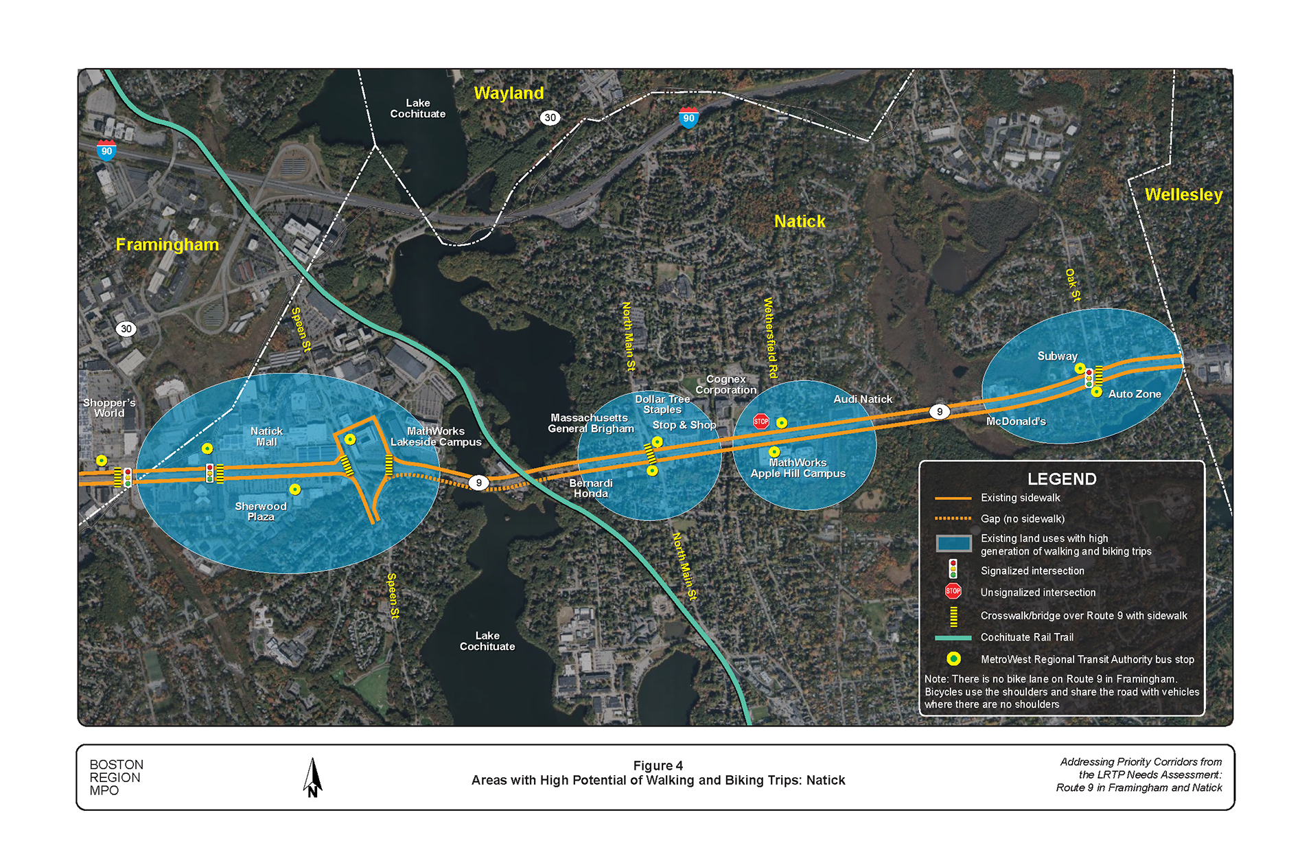
The Route 9 corridor support several land uses with the potential for generating and attracting walking and biking trips. Figures 3 and 4 show these locations and the sites where people can cross Route 9 such as at the signalized intersections and major bridges over the roadway. Spaces between the crossing sites can be as far part as 2.5 miles.
Table 2 presents the number of people walking and biking that were counted at the study intersections during the three-hour collection periods (weekday AM and PM peak periods). The low volumes were attributed to lack of safe walking and biking facilities, which create high stress environment and safety concerns.
Table 2
Peak Period Walking and Biking Volumes
Intersection |
People Walking |
People Biking |
Total |
Route 9 at California Avenue |
8 |
0 |
8 |
Route 9 at Country Club Lane |
0 |
0 |
0 |
Route 9 at Temple Street |
47 |
5 |
52 |
Route 9 at Edgell Road/Main Street |
41 |
1 |
42 |
Route 9 at Prospect Street |
42 |
12 |
54 |
Route 9 at Cochituate Road |
9 |
0 |
9 |
Route 9 at Concord Street (Route 126) |
71 |
18 |
89 |
Route 9 at Caldor Road |
57 |
12 |
69 |
Route 9 at Oak Street |
5 |
7 |
12 |
Note: Weekday AM = 6:00 AM to 9:00 AM. Weekday PM = 3:00 PM to 6:00 PM.
Source: Central Transportation Planning Staff.
Figure 3
Areas with High Potential of Walking and Biking Trips: Framingham
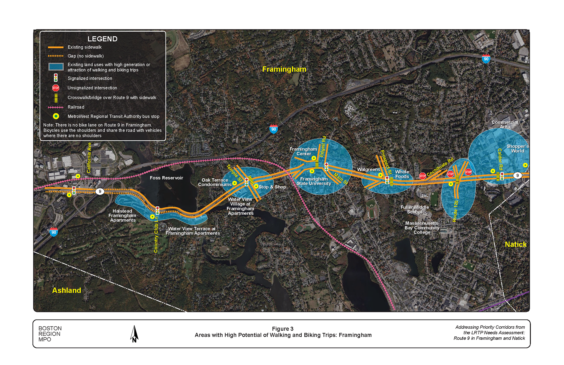
Figure 4
Areas with High Potential of Walking and Biking Trips: Natick
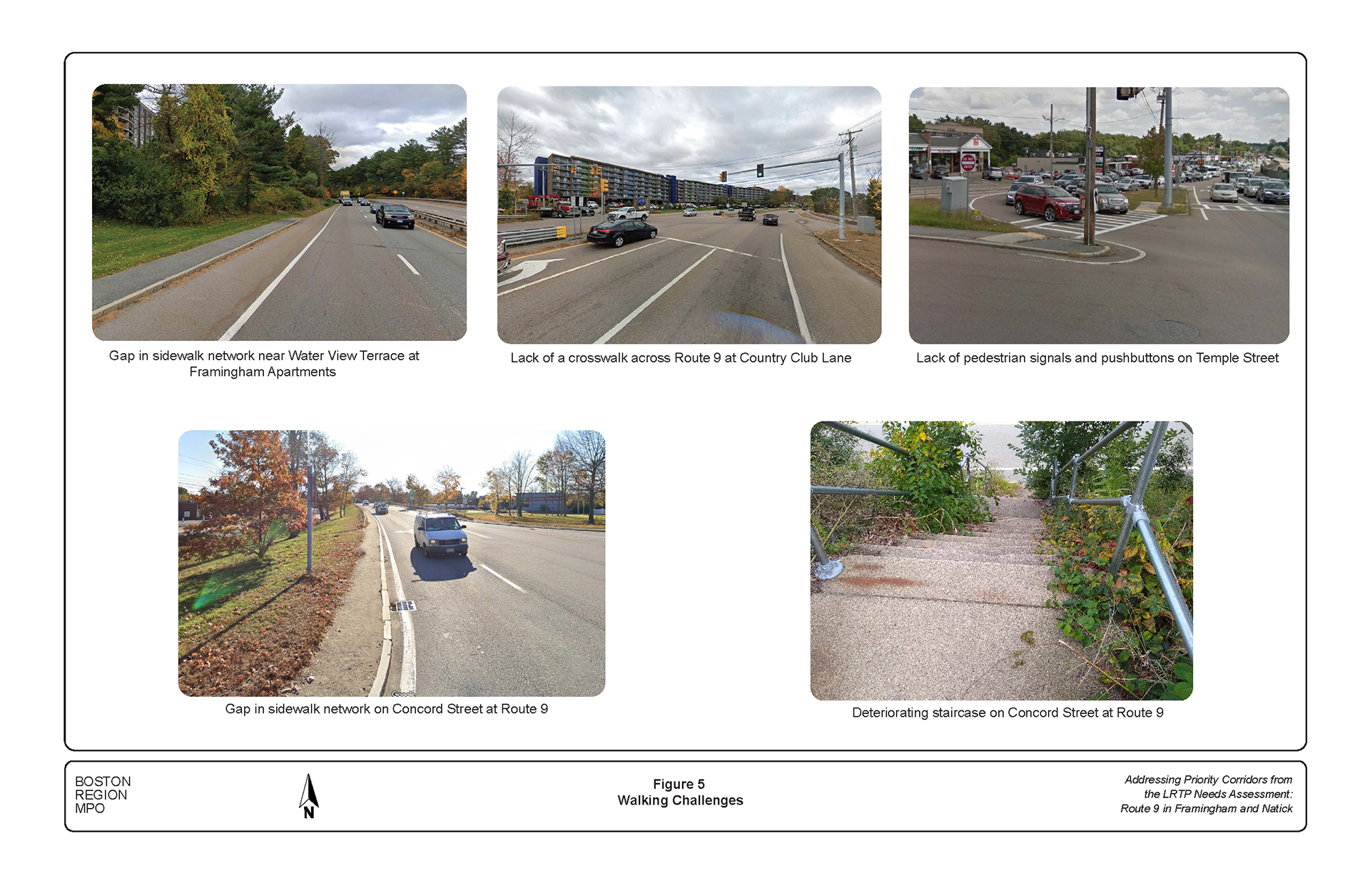
People walking in the corridor are presented with a number of challenges. Out of the four fatal crashes in the corridor three involved people walking. Following analysis of crash data, field reconnaissance, review signal data, and road safety audits, these challenges were identified, some of which are shown in Figure 5.
Figure 5
Walking Challenges
The quality of walking travel is affected by the roadway infrastructure, such as whether there are sidewalks and crosswalks present or pedestrian signals that allow people walking time to cross an intersection before vehicles get a green light. To reflect the complex relationship between people walking and the travel environments, Metropolitan Planning Organization (MPO) staff developed a tool that grades a given roadway on its quality of walking travel and whether it reflects the following objectives: safety, system preservation, capacity management and mobility, and economic vitality.11 Based on the tool, Route 9 in Framingham and Natick was rated poor for all the objectives. Overall, the assessment indicates that the roadway needs improvements to safely accommodate people walking. The ratings from this assessment tool are in Appendix B.
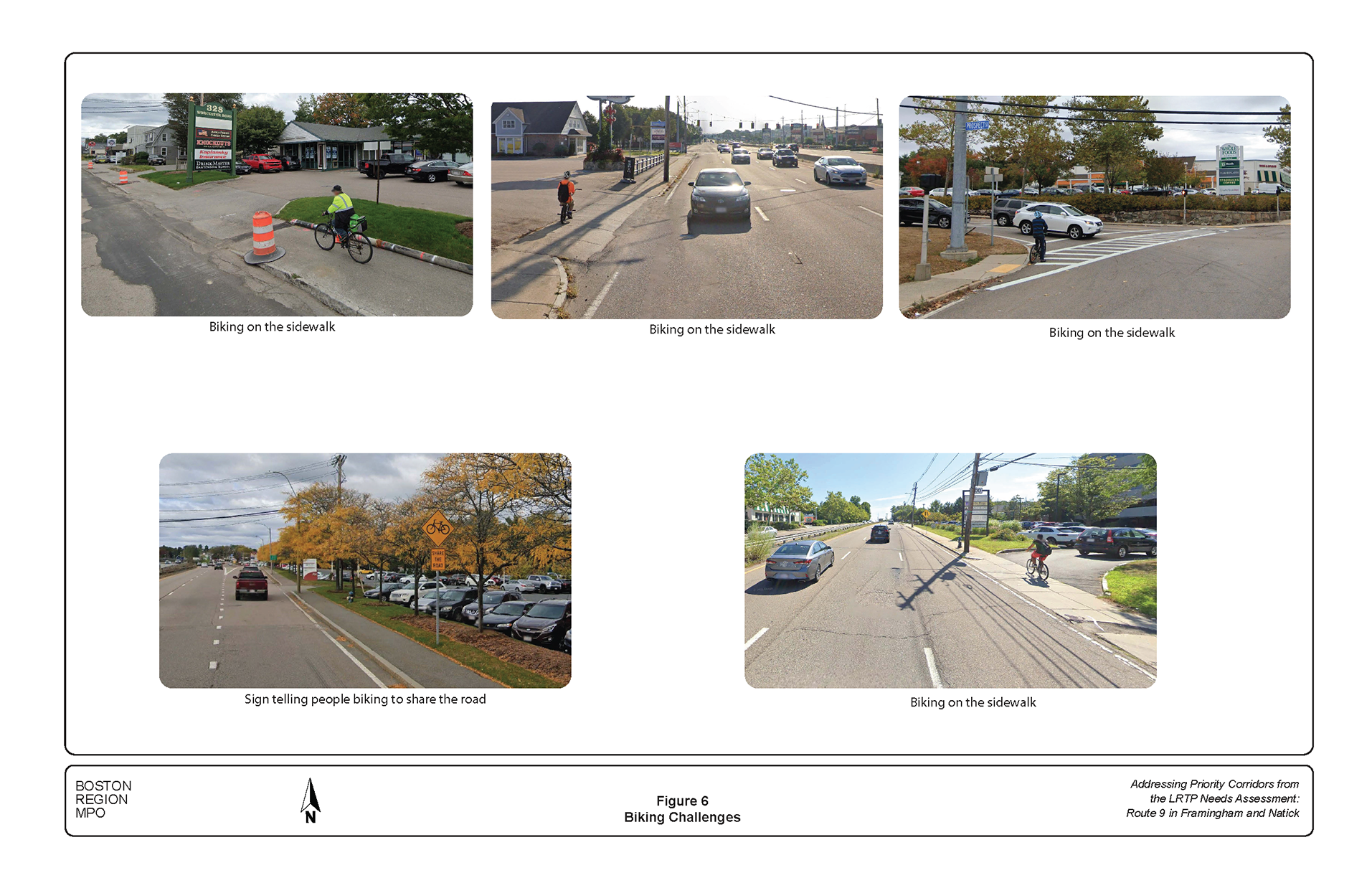
Conditions in the corridor are not favorable for biking. Although there are bikeable shoulders on Route 9 and there are signs installed for people biking to share the road at locations without shoulders, the character of Route 9 does not encourage people to bike in the corridor for safety and security reasons. Following a similar process accessing the walking environment, the following challenges were identified, some of which are shown in Figure 6.
Figure 6
Biking Challenges
The quality of bicycling travel is affected by the character of the roadway, safety, and security, such as speed of vehicles, travel time, comfort and convenience, and freedom to maneuver. The BLOS tool is intended to help users and planners assess the infrastructure to facilitate bicycle travel. The approach is similar to the Pedestrian Level of Service (PLOS) tool in that it grades locations with features that are suitable or unsuitable for bicyclists—areas well suited for bicycle travel are awarded high scores and areas unsuitable for bicycle travel are awarded low scores. In addition, the BLOS ratings correlate with the objectives emphasized for PLOS. Based on the BLOS tool, Route 9 in Framingham and Natick was rated poor in terms of safety, poor in terms of system preservation, poor in terms of economic vitality, and poor in capacity management and mobility. Overall, the assessment indicates that the roadway needs improvements to accommodate bicyclists. The ratings from this bicycle assessment tool are in Appendix B.
The Route 9 corridor in Framingham and Natick and surrounding areas are served by buses operated by the MetroWest Regional Transit Authority (MWRTA). Figures 5 and 6 also shows the MWRTA service stops along Route 9. During weekdays, Route 9 connections can be made by bus routes 1, 2, 3, 4, 7, 8, 9, 10, and 11. On Saturdays, when there is limited service, Route 9 connections can be made by Routes 2, 3, 4, 7, and 10.
People riding the bus are also presented with challenges, which in many ways are similar to those walking or biking listed above. Additional challenges for bus operations and riders include
Route 9 is an automobile centric corridor. It serves both local and regional travel, work and non-work-related travel, including shopping, recreation, and school trips. Like the walking and biking travel, automobile travel is also challenging in the corridor, resulting in many high-crash locations.
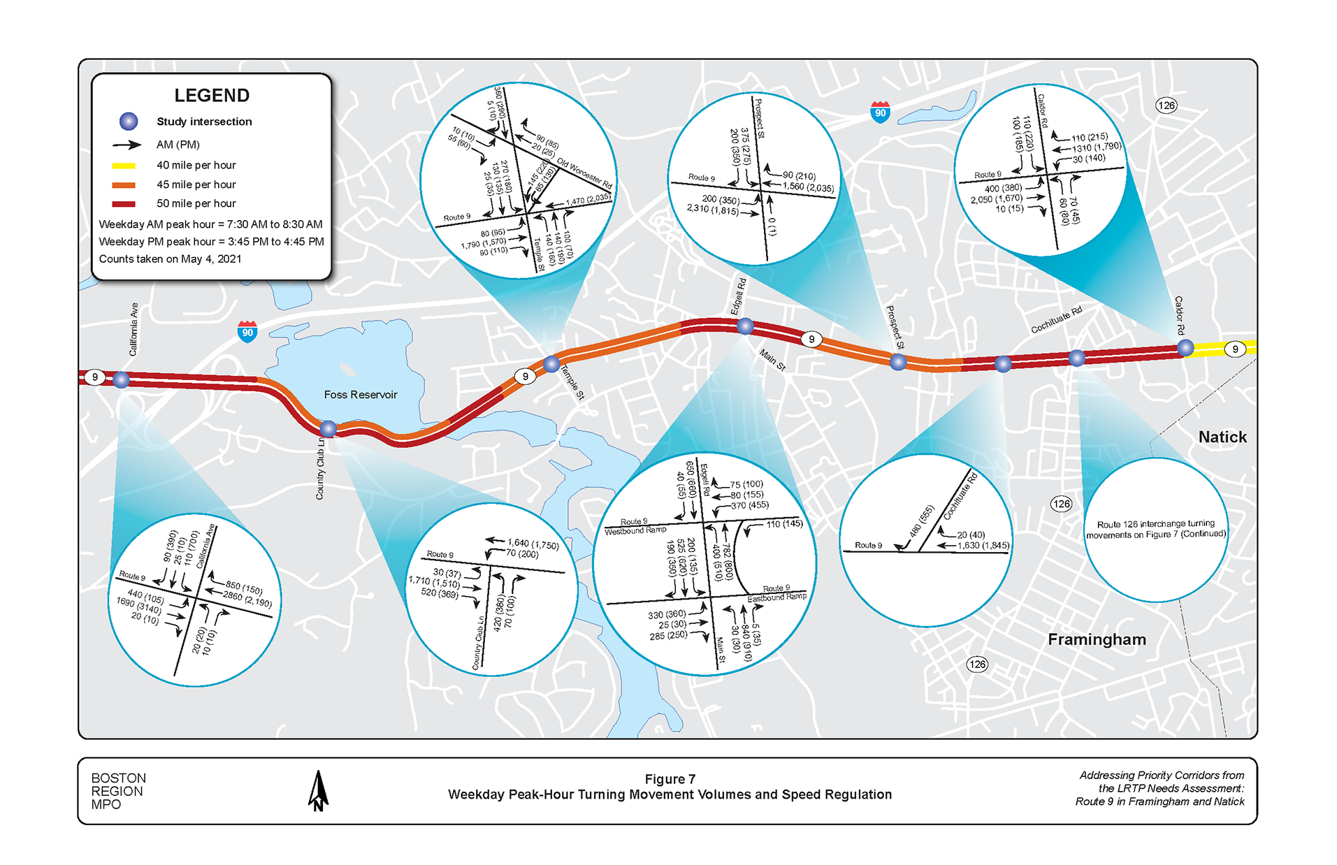
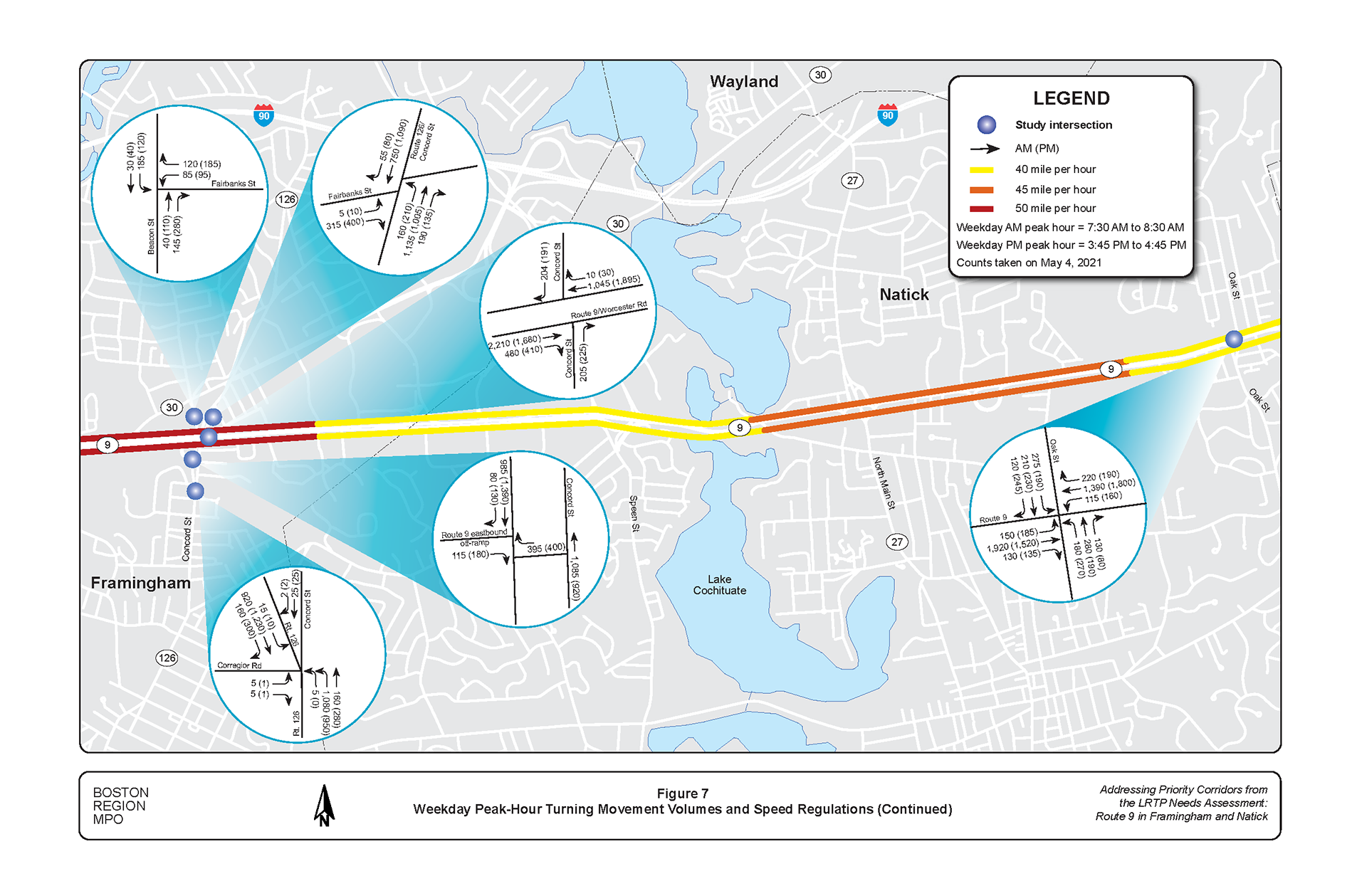
MassDOT Highway Division collected traffic data for analysis. The counts were taken in May 2021. Because of the COVID-19 pandemic, the traffic volumes were on the low side. By comparing the May 2021 counts to 2018 historical counts on Route 9 west of Route 27, it was determined that they were 20 percent lower. In addition, comparing the May 2021 counts to 2019 historical counts obtained from HNTB indicated that the turning volumes to and from the industrial and office parks along the corridor were on the low side. One reason for the low counts was that many workers were working from home or had a shorter workweek. The 2019 counts were used for many of the study intersections along with seasonal and growth factors. For the intersections of Route 9 at Main Street/Edgell Road and Route 9 at Concord Street (Route 126) where there were no 2019 counts, we followed methodology suggested by MassDOT. The May 2021counts were adjusted up by 20 percent along with seasonal and growth factors. Figure 7 shows the turning movement volumes at nine intersections during weekday AM and PM peak hours. The turning movement data are included in Appendix C.
MPO staff conducted traffic operations analyses consistent with the Highway Capacity Manual (HCM) methodologies.12 HCM methodology is used to assess traffic conditions at signalized and unsignalized intersections and to rate the LOS from A to F. LOS A represents the best operating conditions (little to no delay), while LOS F represents the worst operating conditions (long delay). LOS E represents operating conditions at capacity (the limit of acceptable delay). Table 3 presents the control delays (standards for comparison) associated with each LOS for signalized and unsignalized intersections.
Table 3
Intersection Level of Service Criteria
| Level of Service |
Signalized Intersection Control Delay (seconds per vehicle) |
Unsignalized Intersection Control Delay (seconds per vehicle) |
|---|---|---|
A |
< 10 |
< 10 |
B |
10–20 |
10–15 |
C |
20–35 |
15–25 |
D |
35–55 |
25–35 |
E |
55–80 |
35–50 |
F |
> 80 |
> 50 |
Source: Highway Capacity Manual 2010.
Figure 7
Weekday Peak-Hour Turning Movement Volumes and Speed Regulation
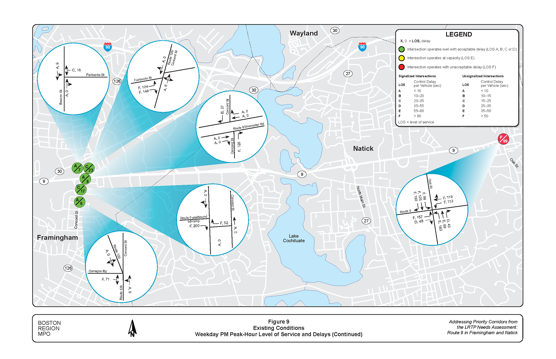
Using Synchro traffic analysis software, MPO assessed the capacity and levels of service of intersections.13 Figures 8 and 9 show the analysis results for the weekday AM and weekday PM, respectively. Appendix D presents the existing conditions LOS analysis worksheets. Based on the traffic operations analyses, the following intersections were found to operate under congested conditions and have long queues during peak travel hours:
Figure 8
Existing Conditions: Weekday AM Peak-Hour Level of Service and Delays


Figure 9
Existing Conditions: Weekday PM Peak-Hour Level of Service and Delays

Analysis of Route 9 crash data obtained from MassDOT’s Registry of Motor Vehicles database from January 2015 through December 2019 is presented in Table 4. The data comprise crashes that occurred at the eight Highway Safety Improvement Program intersection clusters in the corridor and at the Maynard Road intersection and Routes 9 and 126 interchange. During the five-year analysis period, a total of 954 crashes were recorded in the corridor at the 10 locations. Table 4 presents a summary of the crash statistics.
Table 4
Summary of Intersection Crash Statistics: 2015–19
Crash Variable |
5-Year Total |
Percent |
||
Total number of crashes |
954 |
100 |
||
Severity: Property damage only |
723 |
76 |
||
Severity: Possible injury |
69 |
7 |
||
Severity: Non-incapacitating |
136 |
14 |
||
Severity: Incapacitating |
18 |
2 |
||
Severity: Fatality |
4 |
0 |
||
Severity: Not reported/unknown |
5 |
1 |
||
Collision type: Single vehicle |
79 |
8 |
||
Collision type: Rear-end |
465 |
49 |
||
Collision type: Angle |
212 |
22 |
||
Collision type: Head-on |
9 |
1 |
||
Collision type: Sideswipe, same direction |
182 |
19 |
||
Collision type: Sideswipe, opposite direction |
6 |
1 |
||
Collision type: Not reported/unknown |
1 |
0 |
||
Daylight |
662 |
69 |
||
Dark—lighted roadway |
226 |
24 |
||
Dark—unlit roadway |
24 |
3 |
||
Dark—unknown |
4 |
0 |
||
Dawn |
11 |
1 |
||
Dusk |
25 |
3 |
||
Unknown/other |
2 |
0 |
||
Involved pedestrian(s) |
14 |
1 |
||
Involved cyclist(s) |
6 |
1 |
||
Occurred during weekday peak periods* |
309 |
32 |
||
Wet or icy pavement conditions |
164 |
17 |
||
Dark conditions (lit or unlit) |
254 |
27 |
||
* Peak periods are 6:00 AM to 9:00 AM and 3:00 PM to 7:00 PM, Monday through Friday.
Source: Central Transportation Planning Staff.
MPO staff prepared collision diagrams for the 10 locations to examine patterns within the crash data and factors contributing to the crashes. The collision diagrams are included in Appendix E. The associated tables may be used to look up additional details for specific crash events. The collision diagrams reveal the safety problems outlined in the following sections.
Based on the summaries and collision diagrams, the following characteristics were identified.
Figures 10 through 20 show the problems at 11 intersections selected for study. Together, they show the need for following:
Figure 10
Problems: Route 9 and California Avenue Intersection
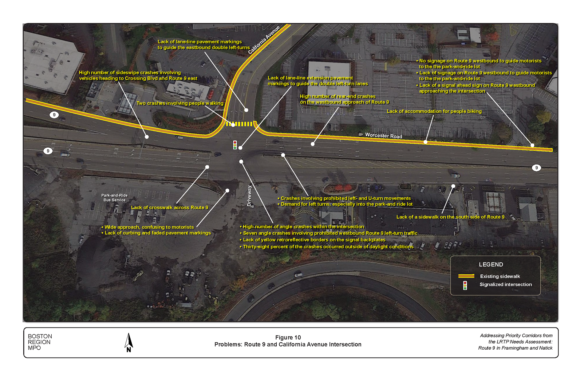
Figure 11
Problems: Route 9 and Country Club Lane Intersection
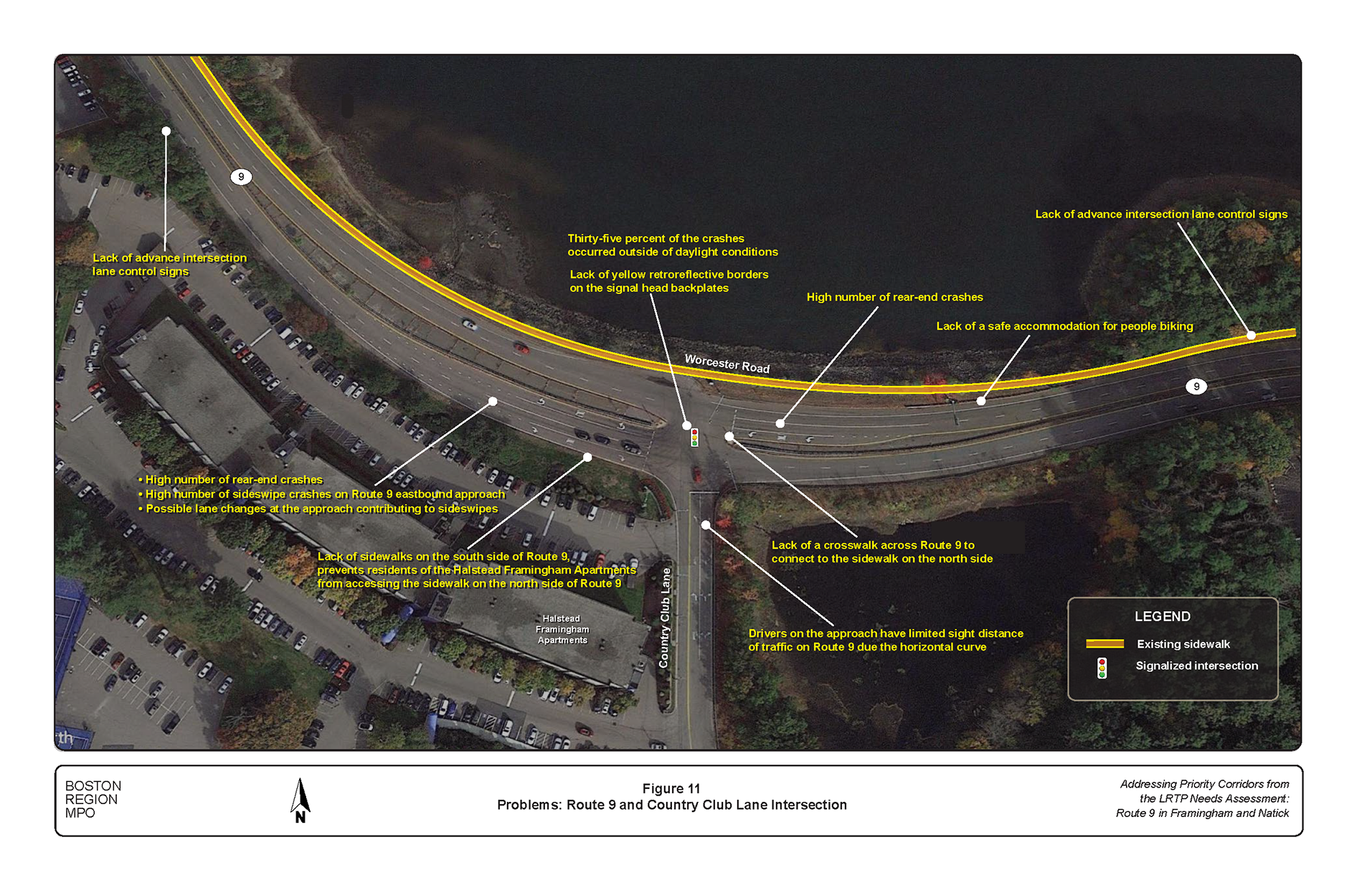
Figure 12
Problems: Route 9 and Temple Street Intersection
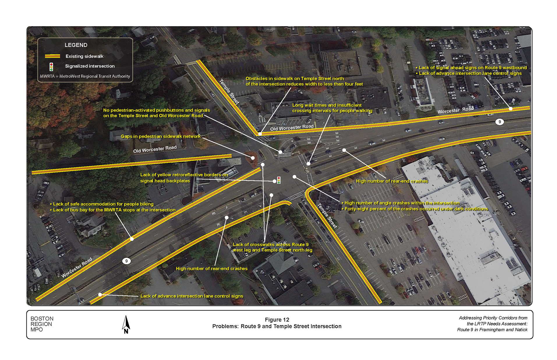
Figure 13
Problems: Route 9 and Maynard Road Intersection
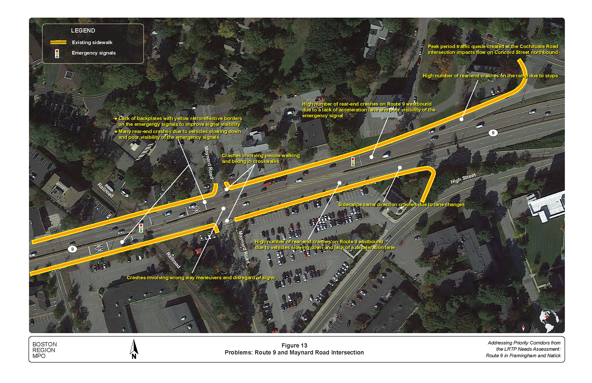
Figure 14
Problems: Route 9 and Main Street/Edgell Road Intersection
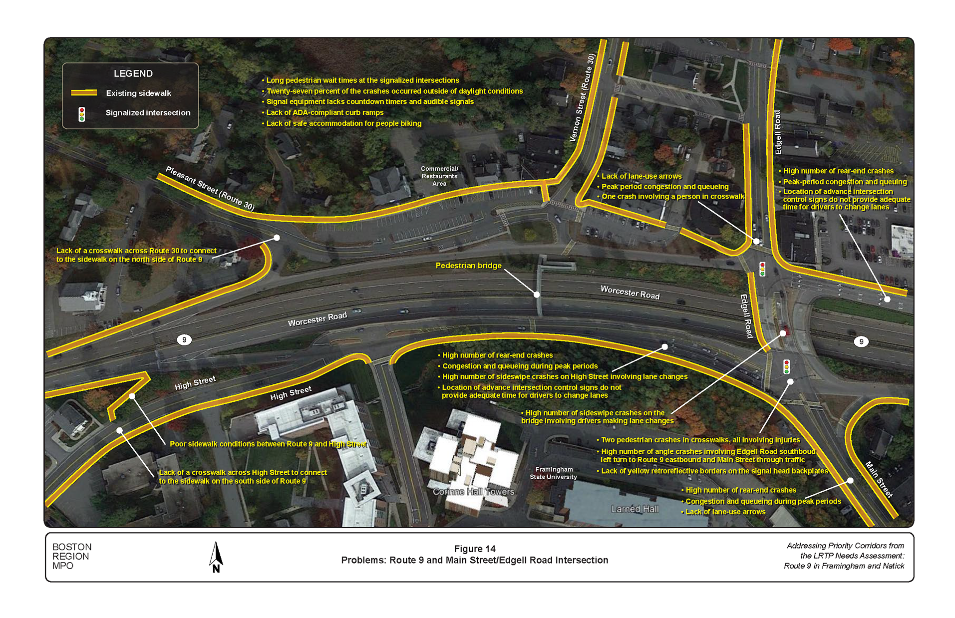
Figure 15
Problems: Route 9 and Prospect Street Intersection
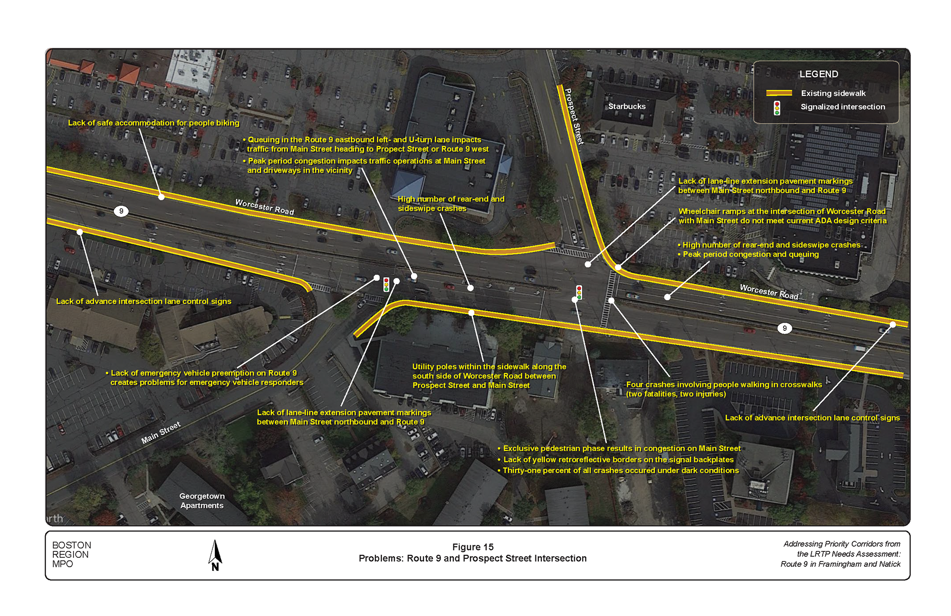
Figure 16
Problems: Route 9 and Cochituate Road Intersection
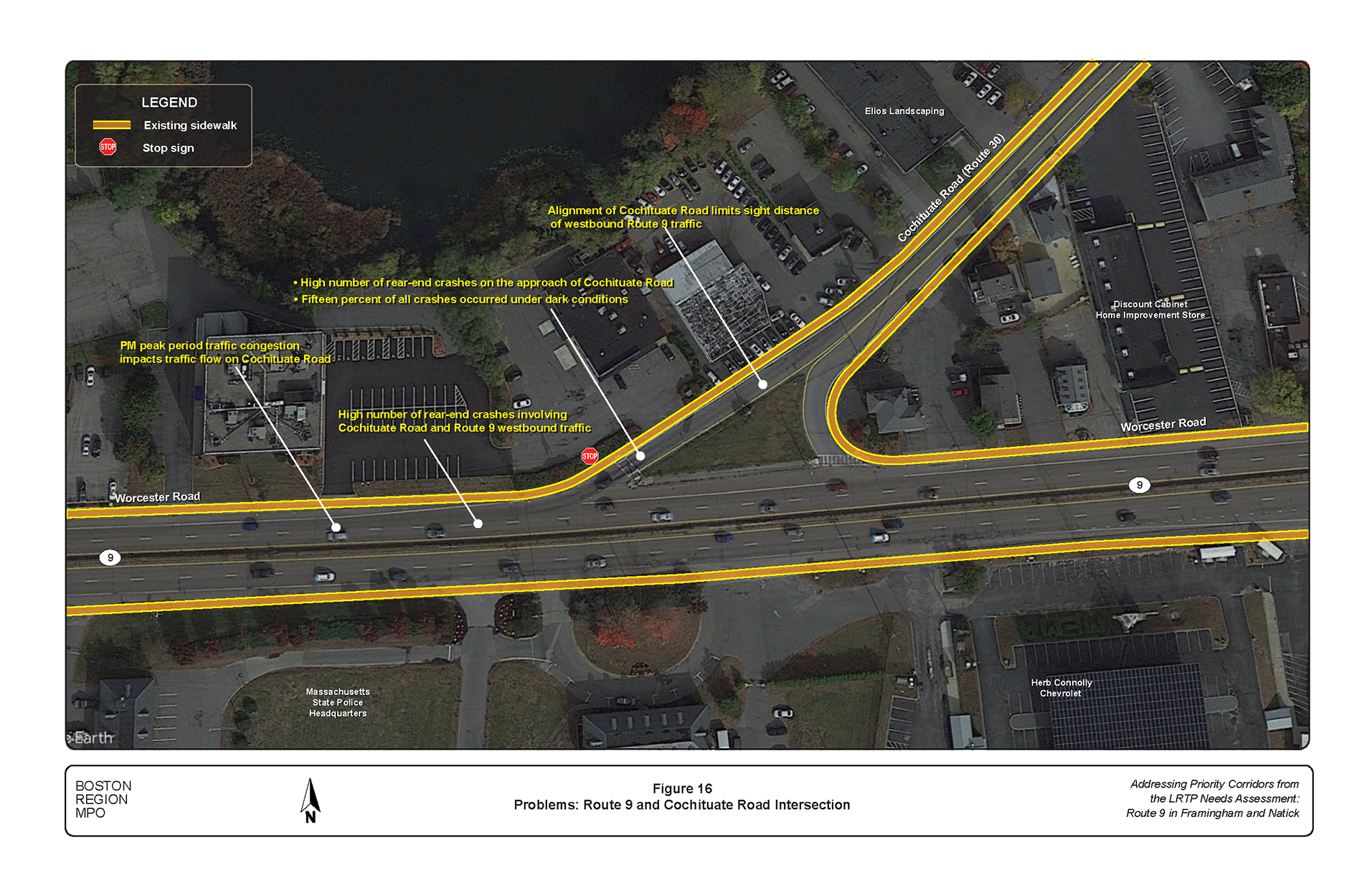
Figure 17
Problems: Route 9 and Concord Street (Route 126) Interchange
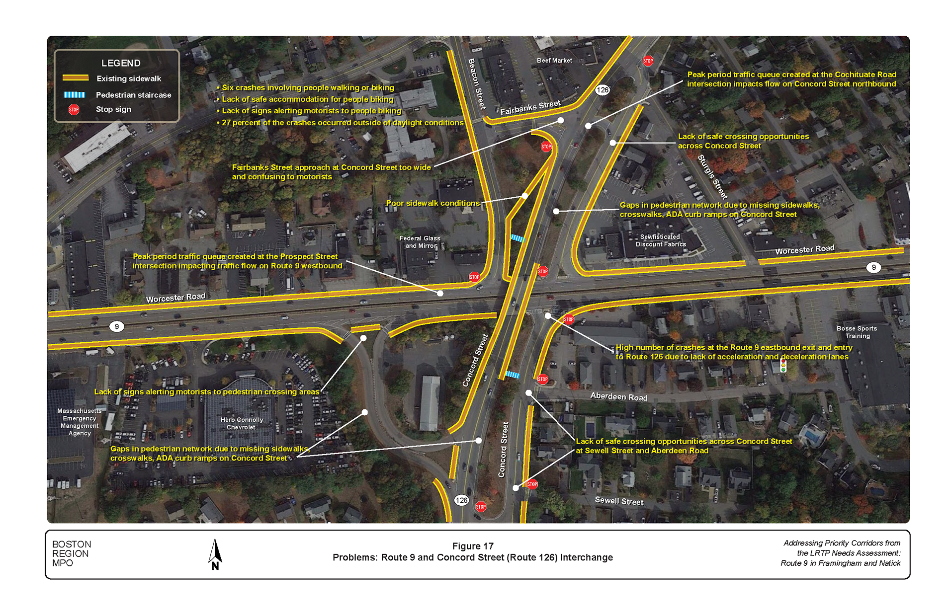
Figure 18
Problems: Route 9 and Caldor Road Intersection
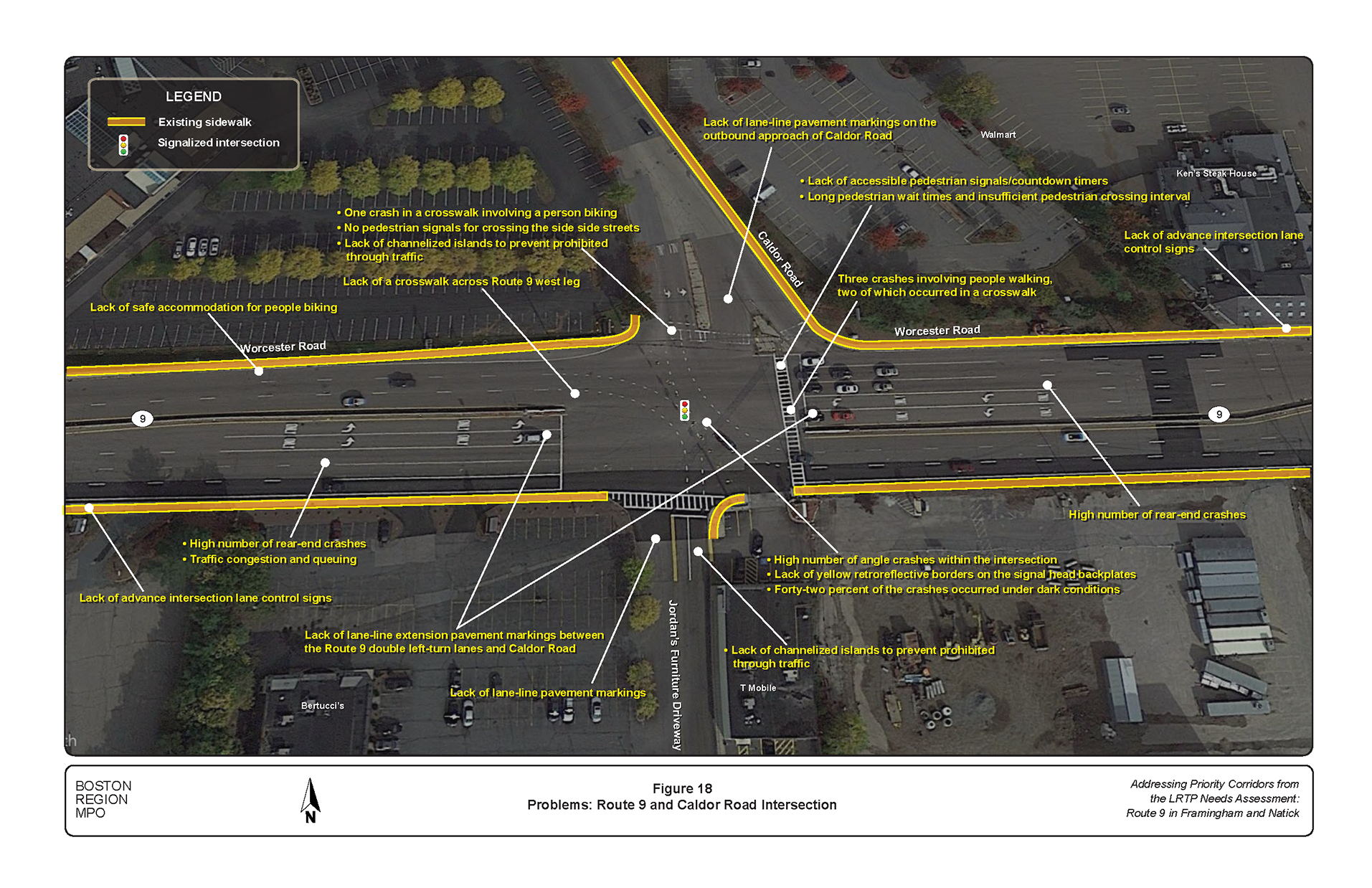
Figure 19
Problems: Route 9 and Speen Street Interchange
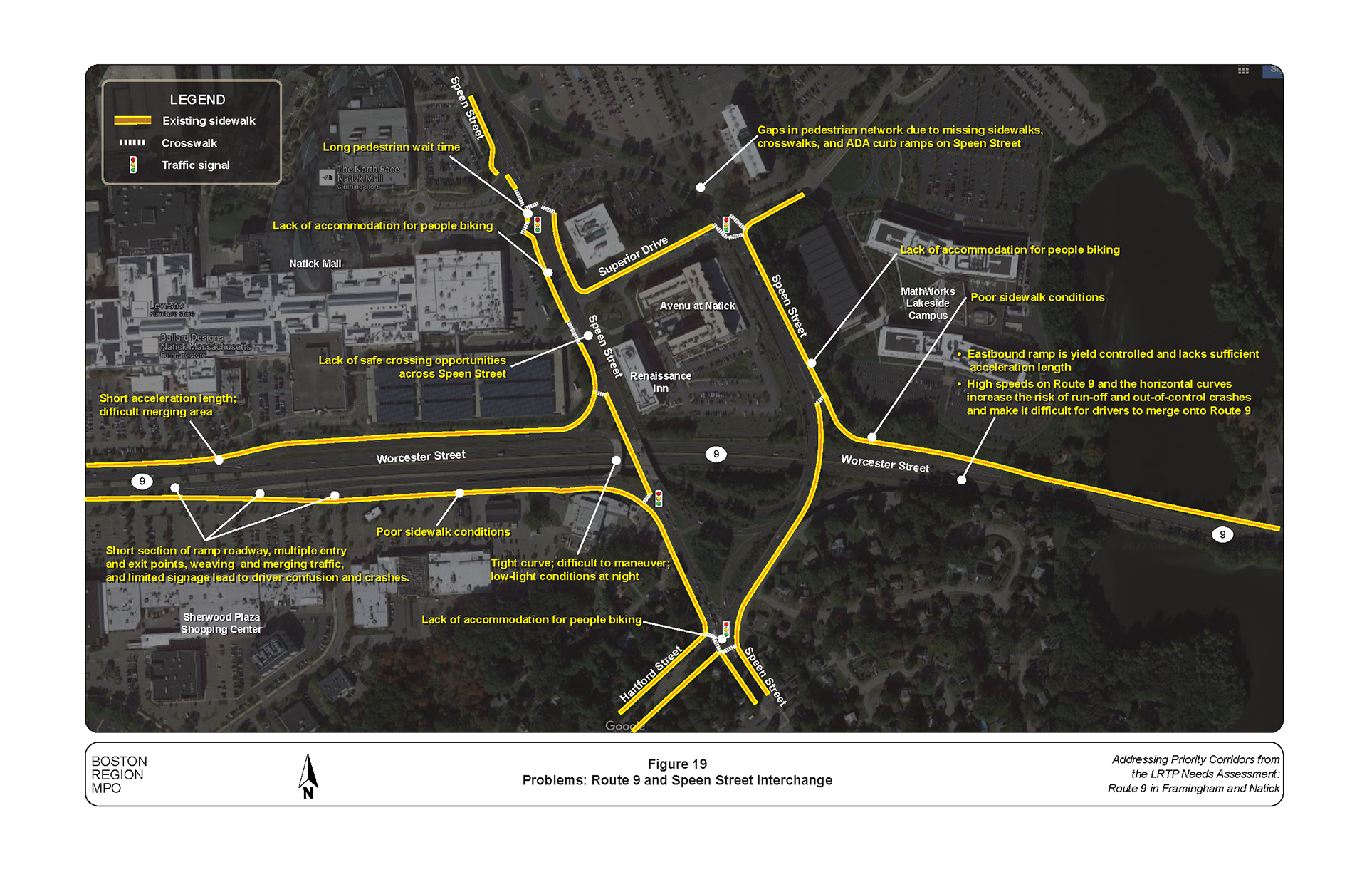
Figure 20
Problems: Route 9 and Oak Street Intersection
The following improvements apply to the entire corridor.
The intersection-related improvements are described in Figures 21 through 31. They include some of the corridor-wide improvements as well as specific measures to reduce crashes and congestion and accommodate people walking, biking, and taking the bus. All improvements fall within the roadway’s right-of-way width and considers the needs of abutters and users.
The time frame categorized as short-term is typically less than five years and the costs are typically low, which can be funded through maintenance budgets. Some of the short-term improvements could be included in MassDOT’s projects that are currently under construction, in design, or through maintenance activities. These improvements include installing new signs, upgrading old signs, pavement stripping, painting high-visibility crosswalks, adding detectable warning plates to curb ramps, upgrading signal-head sections, and adding yellow retroreflective backplates. Additional improvements include adding countdown timers, retiming and coordinating signals, and repairing substandard sidewalks.
Figure 21
Improvements: Route 9 and California Avenue Intersection
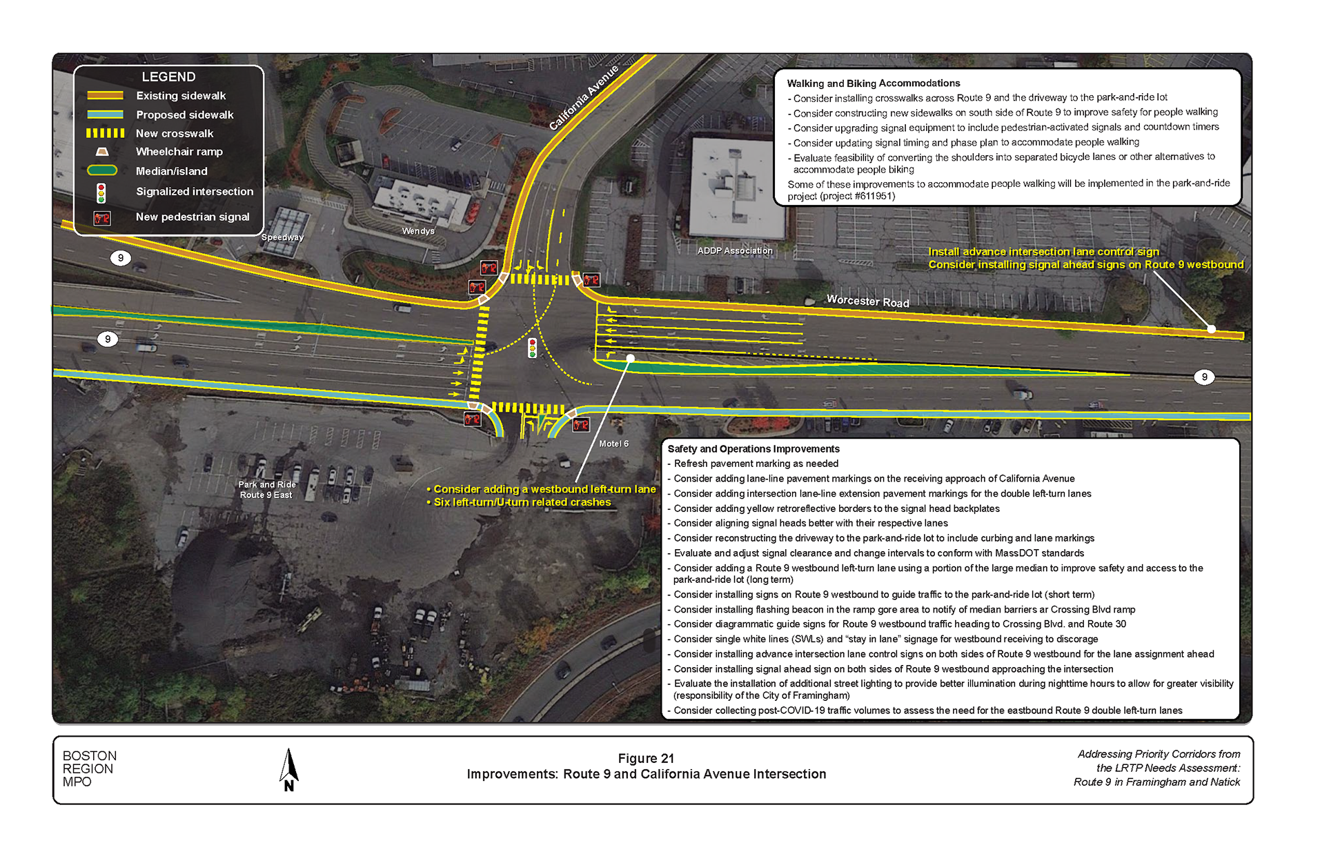
Figure 22
Improvements: Route 9 and Country Club Lane Intersection
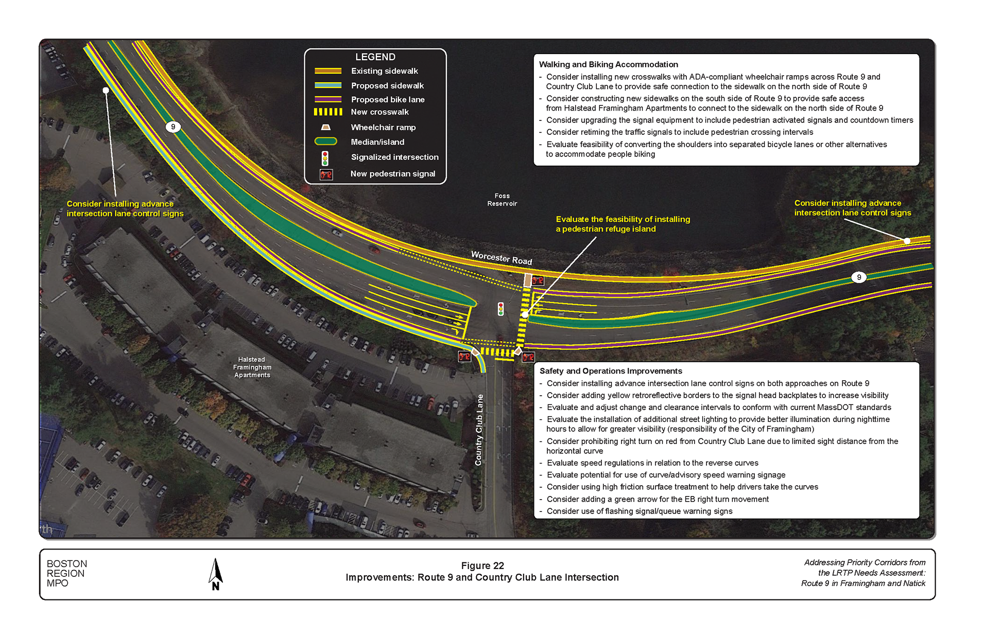
Figure 23
Improvements: Route 9 and Temple Street Intersection
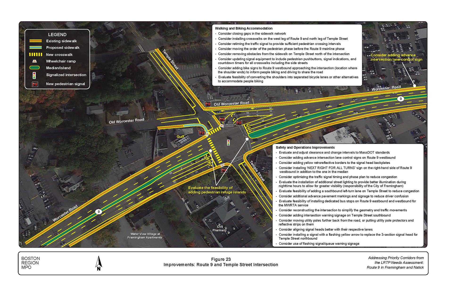
Figure 24
Improvements: Route 9 and Maynard Street Intersection
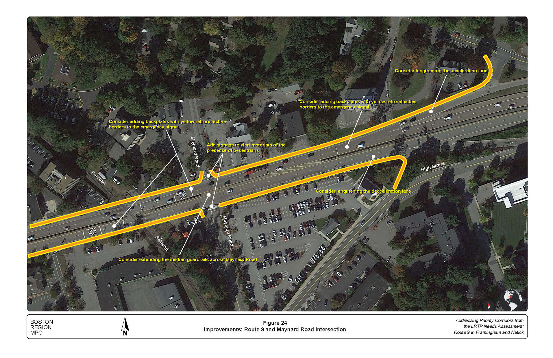
Figure 25
Improvements: Route 9 and Main Street/Edgell Road Intersection
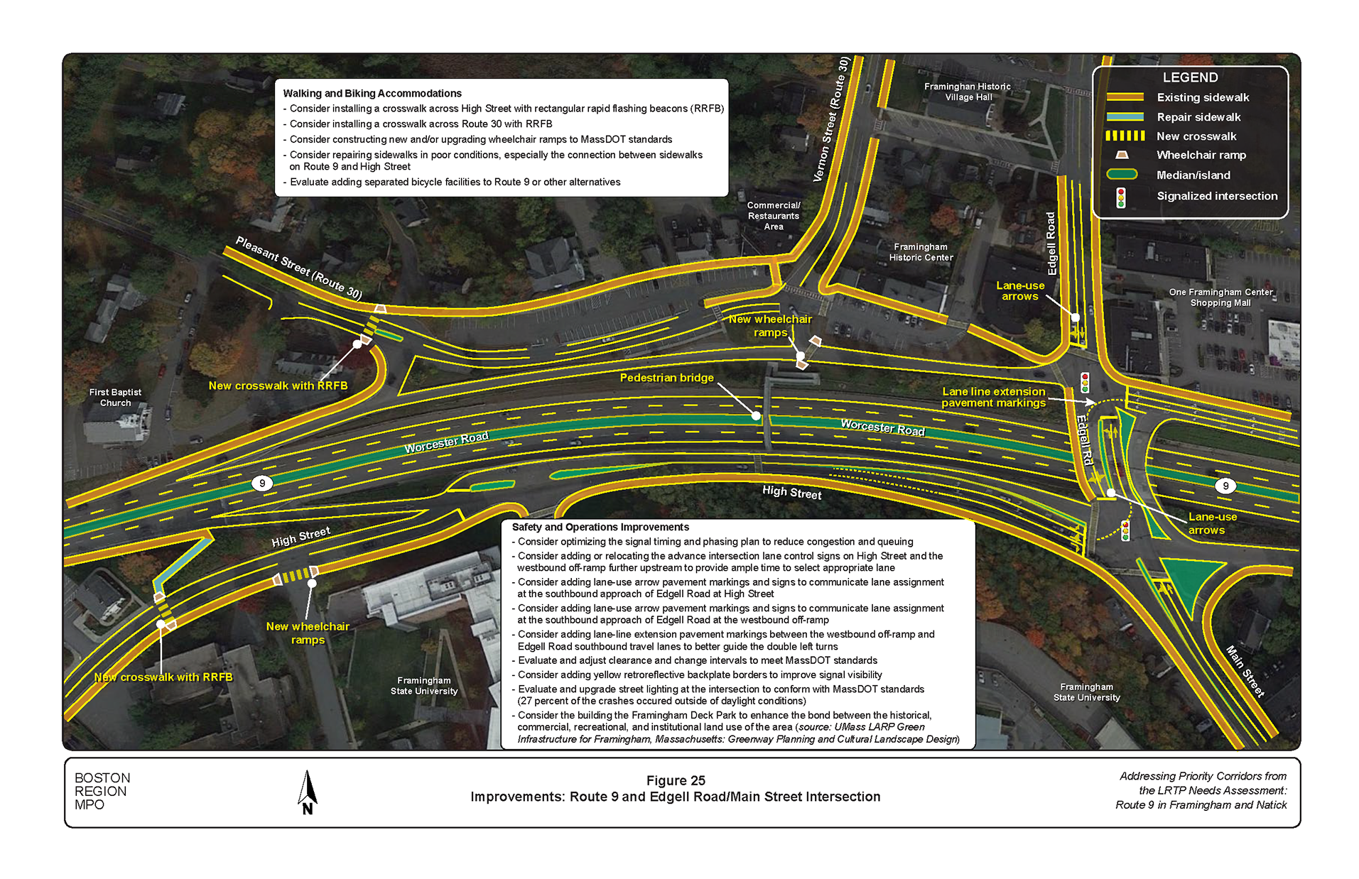
Figure 26
Improvements: Route 9 and Prospect Street Intersection
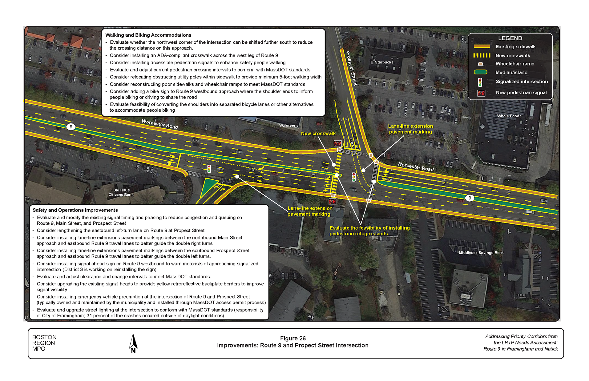
Figure 27
Improvements: Route 9 and Cochituate Road Intersection
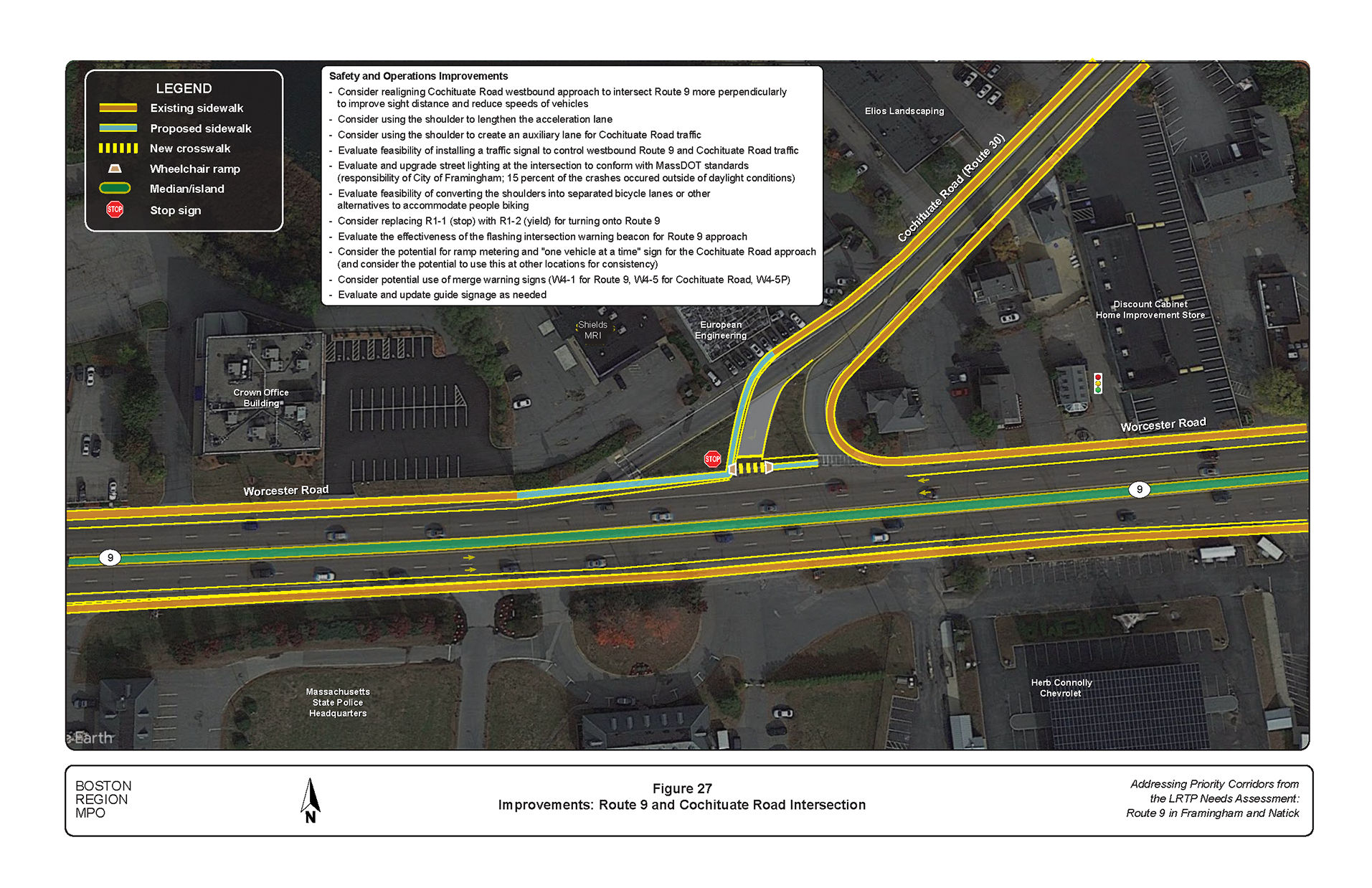
Figure 28
Improvements: Route 9 and Concord Street (Route 126) Interchange
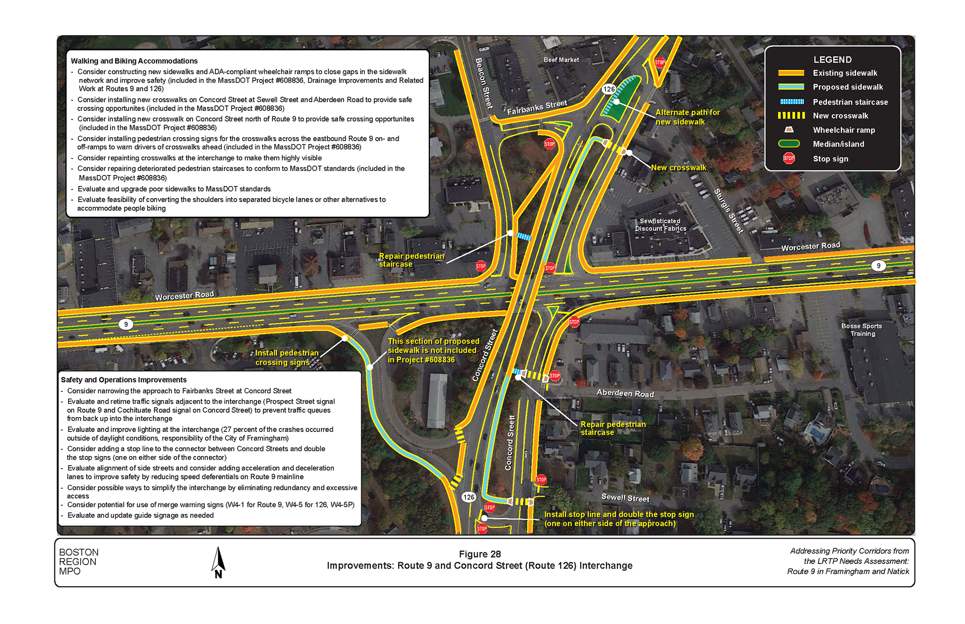
Figure 29
Improvements: Route 9 and Caldor Road Intersection
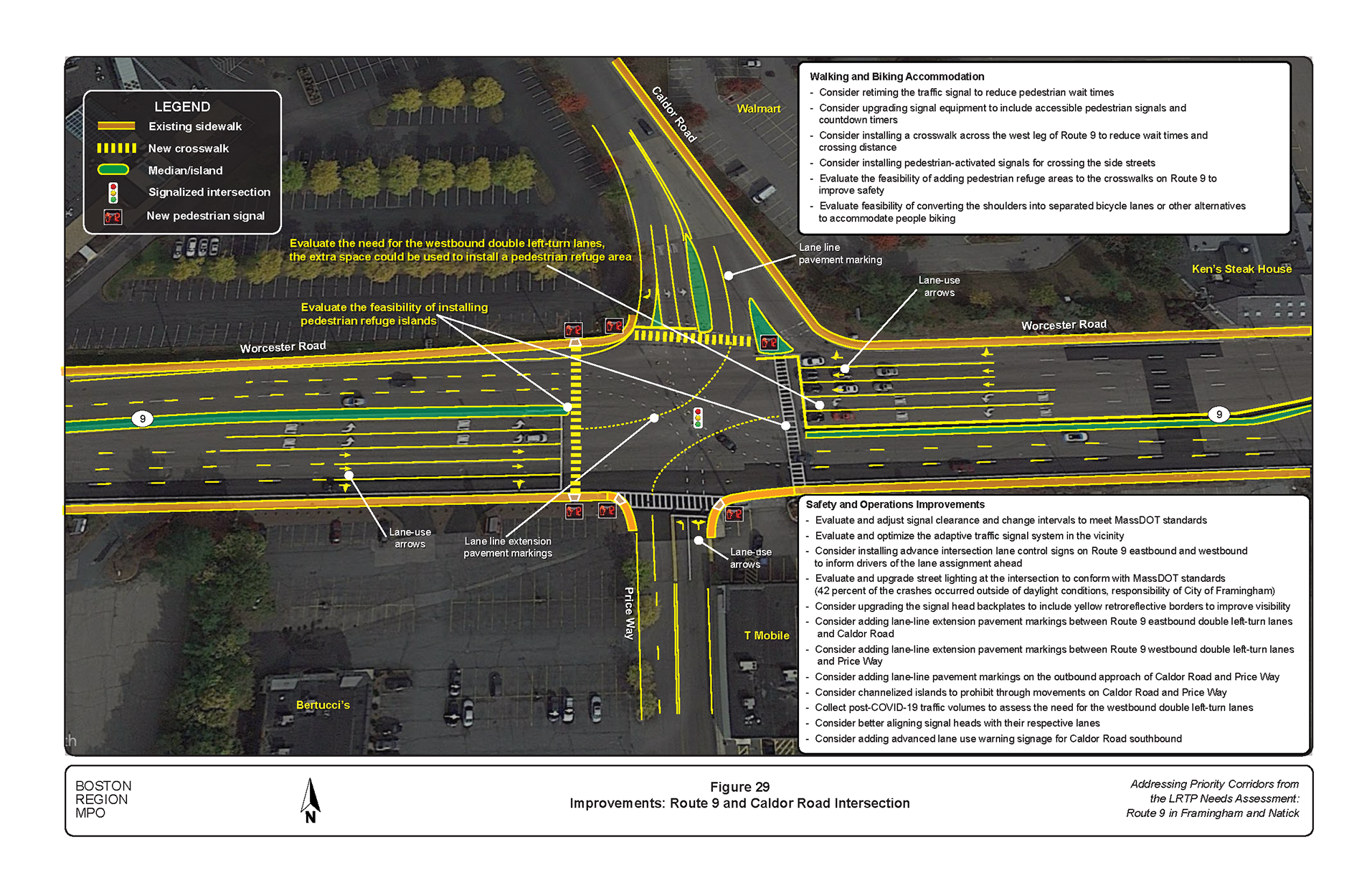
Figure 30
Improvements: Route 9 and Speen Street Interchange
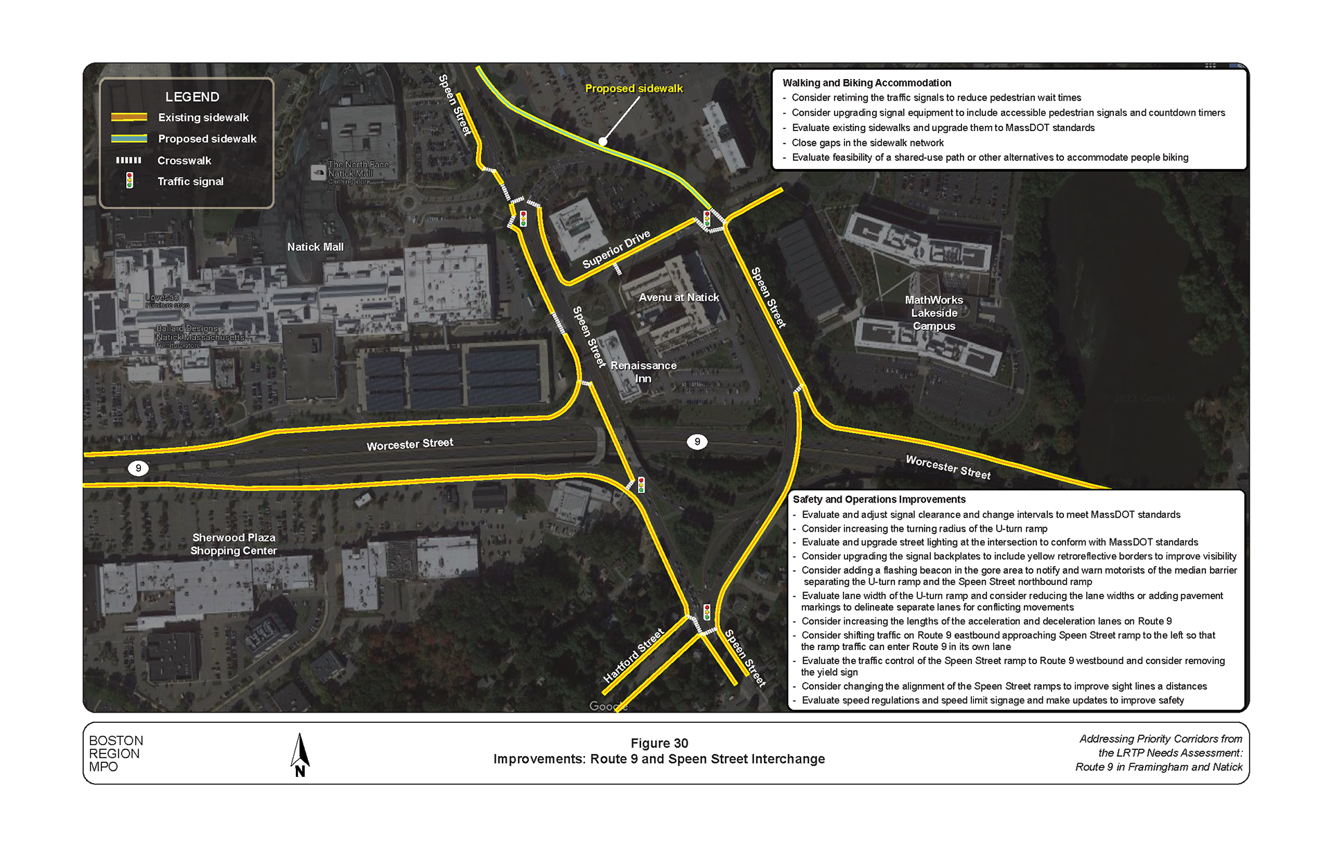
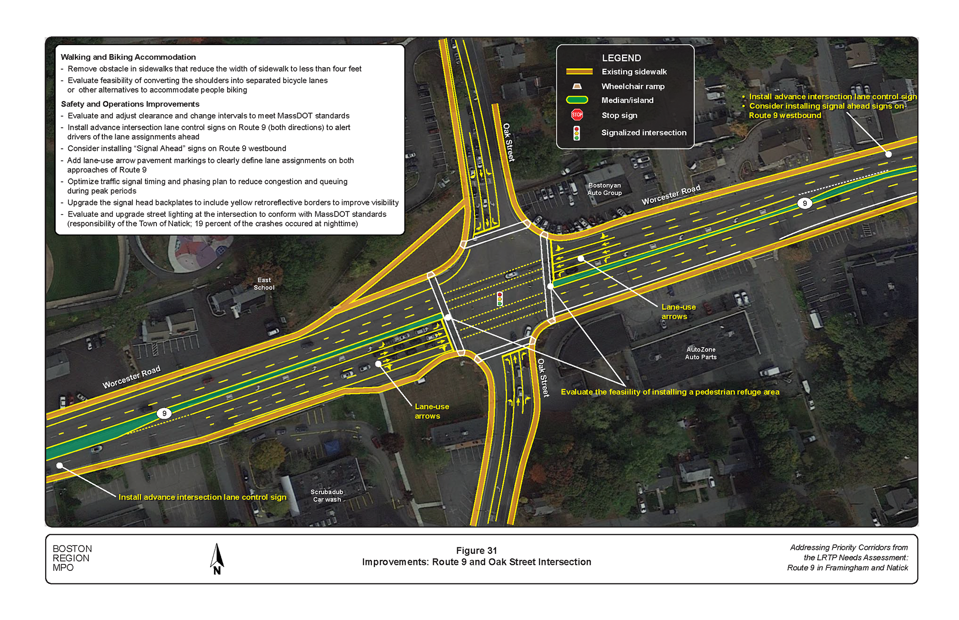
Figure 31
Improvements: Route 9 and Oak Street Intersection
The time frame categorized as long-term is typically more than five years. Long-term improvements require design and engineering efforts and larger funding sources. The long-term improvements address safety and multimodal transportation needs, such as increased safety for people who walk, bicycle, or ride the bus, and to support livable communities and economic vitality. They include safety improvements such as upgrading major signal equipment and timing, adding separated bike facilities, constructing new sidewalk or upgrading sidewalks and curb ramps to MassDOT standards, opening the Route median at several locations to construct additional safe crossing opportunities for people walking and biking or building pedestrian bridges, and reconstructing intersections to improve safety. Figures 32 through 35 show some of the improvements to address walking and biking issues.
The Boston Region MPO’s transportation planning model, which was adopted for the Long-Range Transportation Plan, was used for forecasting traffic. The model’s socioeconomic components are derived from forecasts produced by the Metropolitan Area Planning Council. Using this model, staff projected that between now and 2030, traffic volume on Route 9 in Framingham and Natick would grow by 0.25 percent annually in the AM peak period and 0.3 percent annually in the PM peak period. These growth rates also apply to the intersecting streets, as they are usually developed for areas, not specific streets.
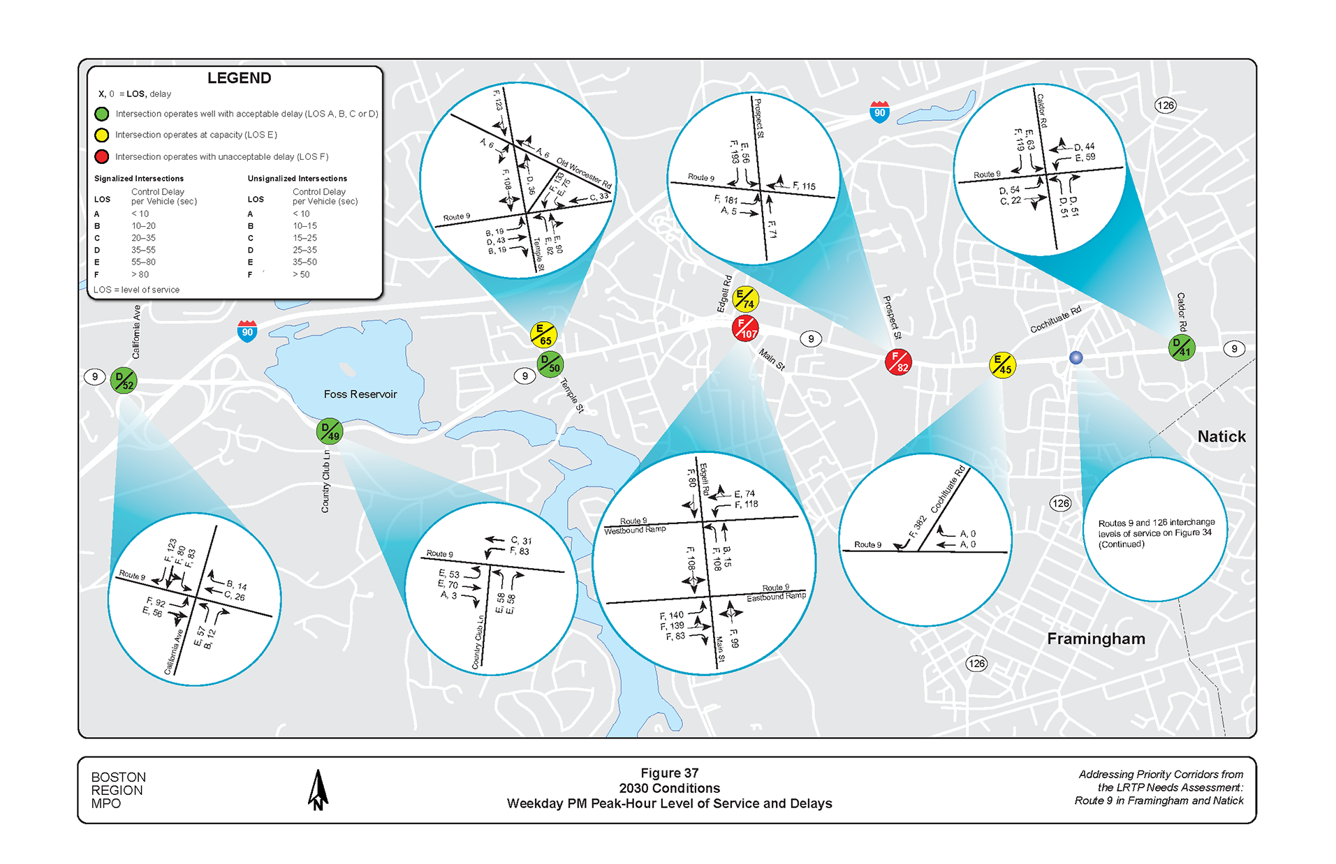
The LOS analysis focused on using the future volumes and optimized signal timings, phase sequences, and pedestrian phases from the Signal Phase and Timing Challenge (SPaT C) to determine the effects of changes.14 ,15 ,16 The results of the future LOS analyses are shown in Figures 36 and 37. Appendix D presents the future LOS analysis worksheets. The existing and future LOS analyses indicated that the proposed improvements would prevent congestion from worsening—less than 3 percent increase delay from 2021 to 2030.
Figure 32
Separated Bike Lane Designs
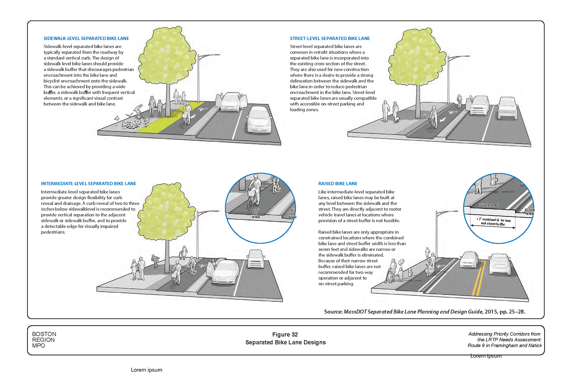
Figure 33
Roadway Accommodation Improvement Alternatives
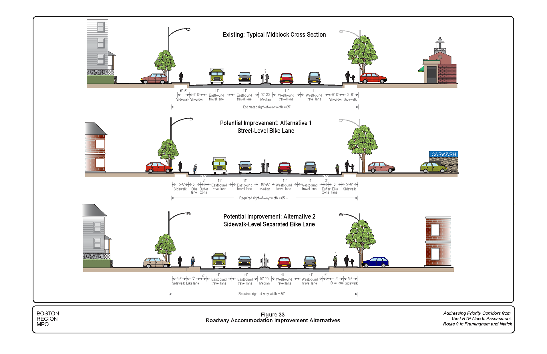
Figure 34
Examples of Bike Accommodations
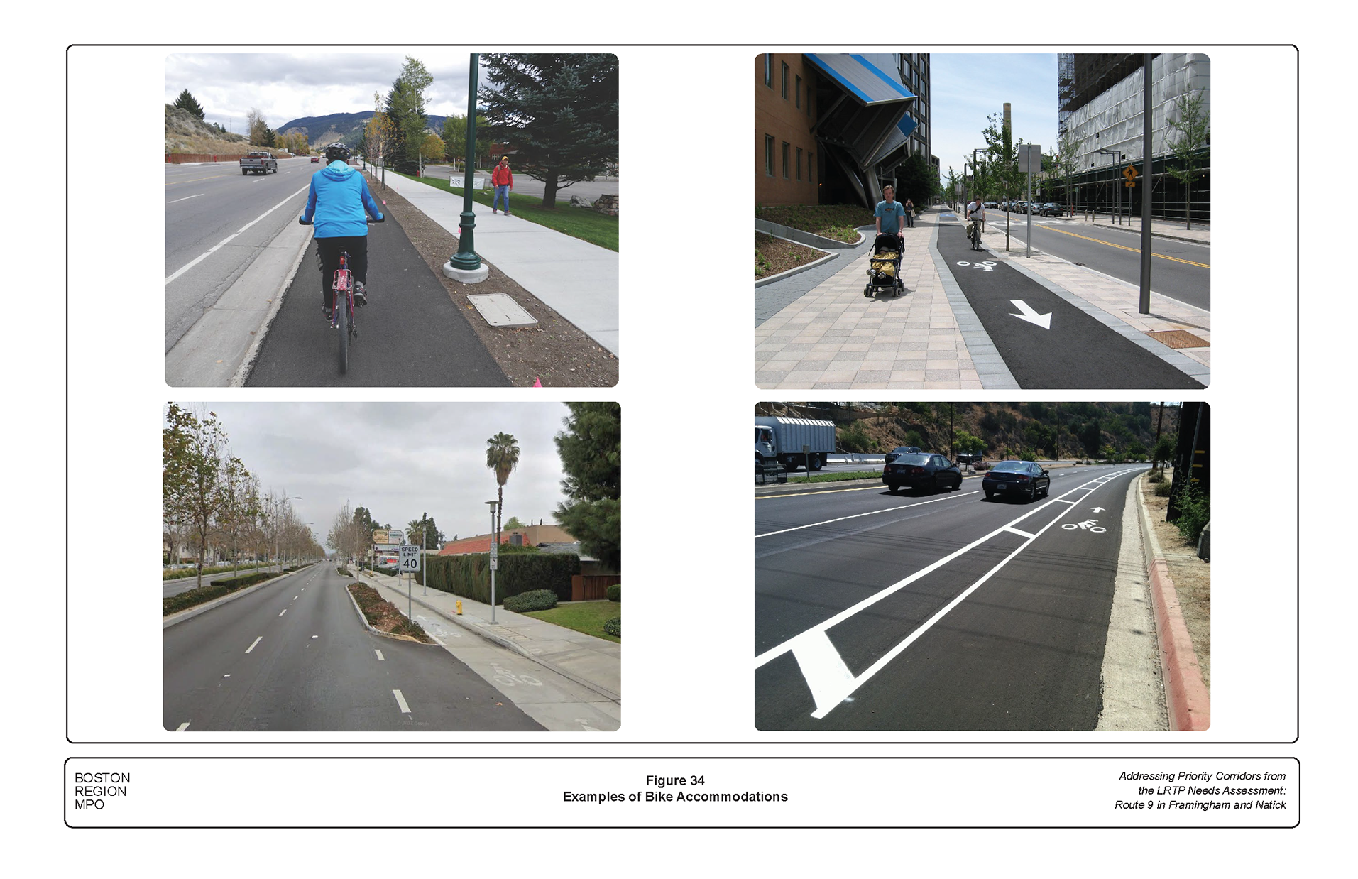
Figure 35
Safe Crossing Opportunities: Improvements for Walking and Biking
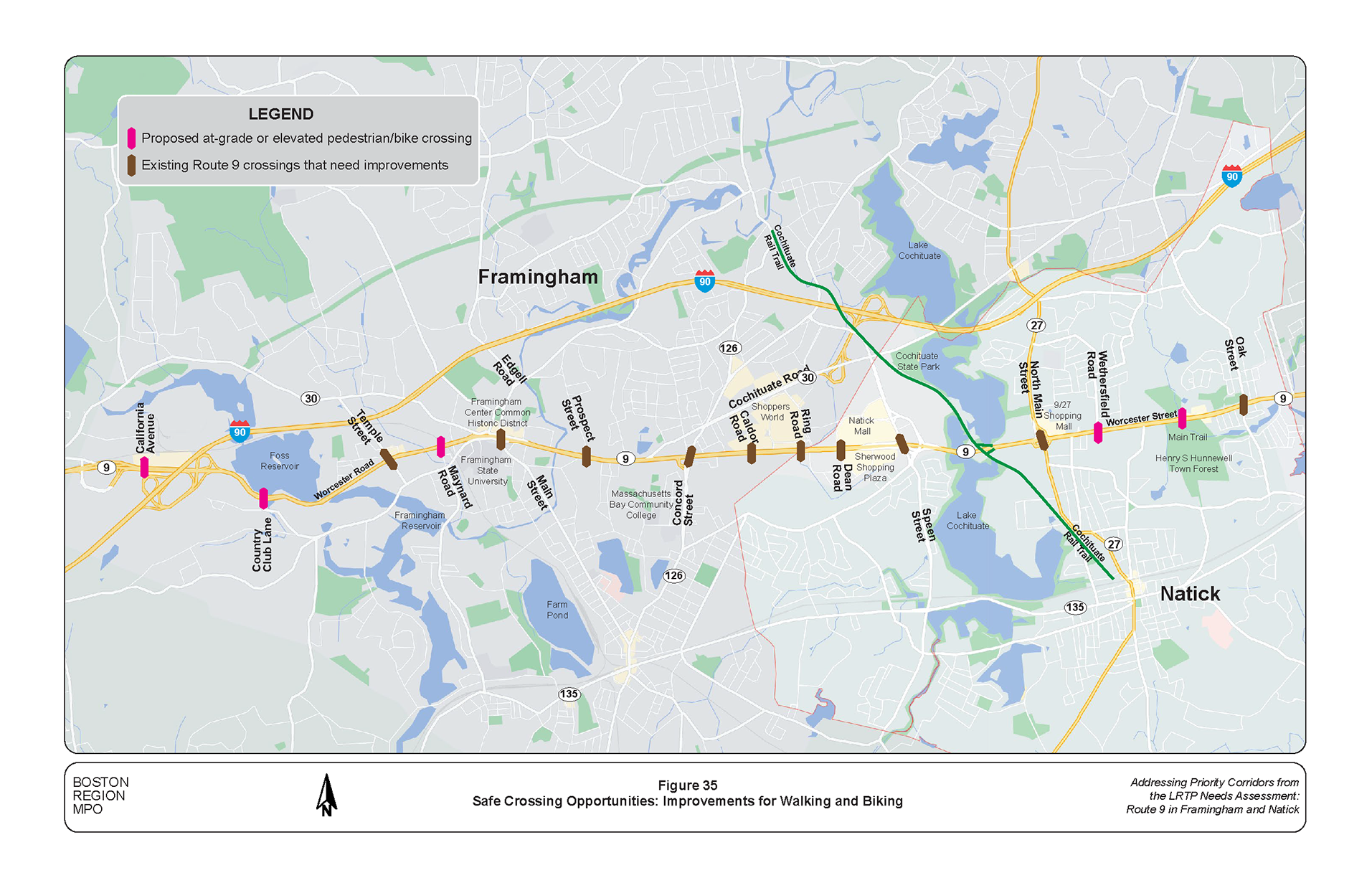
Currently, crossing Route 9 is possible at only a few locations at some signalized intersections and bridges over Route 9. Over the nine-mile corridor, there are only 10 locations where people walking and biking can safely cross Route 9: five locations in Framingham and another five locations in Natick. Opening the Route 9 median at several locations to install safe crossing opportunities for people walking and biking would enhance connections between neighborhoods north and south of Route 9. Alternatively, building pedestrian bridges at vantage points for crossing Route 9 safely would work. Additional improvements include ADA-compliant sidewalks and wheelchair ramps, accessible pedestrian signals, pedestrian refuge islands, adequate pedestrian crossing times, and moving pedestrian phases to occur before the Route 9 phases.
MPO staff evaluated what the future LOS for people walking would be if the pedestrian safety improvements from this study were implemented. Appendix B contains results of the LOS scorecard analyses. Based on the assessment, Route 9 was rated good in terms of meeting the MPO’s goals for safety, capacity management and mobility, and system preservation; and fair for economic vitality because of the prioritization of safe accommodations for people who walk.
Presently, Route 9 lacks safe accommodations for people biking; MPO staff recommends long-term improvements to construct sidewalk-level or street-level separated bike lane. MPO staff evaluated what the future LOS for people biking would be if the sidewalk-level or street-level separated bike lane recommendations were implemented. Appendix B contains results of the LOS scorecard analyses. Based on the assessment, Route 9 was rated excellent in terms of meeting the MPO’s goals for capacity management and mobility and system preservation, and acceptable for safety and economic vitality because of the prioritization of safe accommodations for people who bike.
Figure 36
2030 Conditions: Weekday AM Peak-Hour Level of Service and Delays
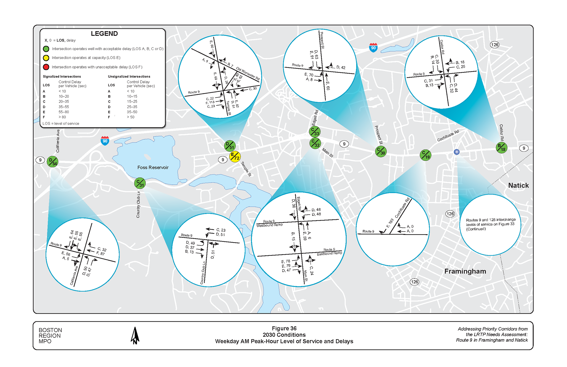
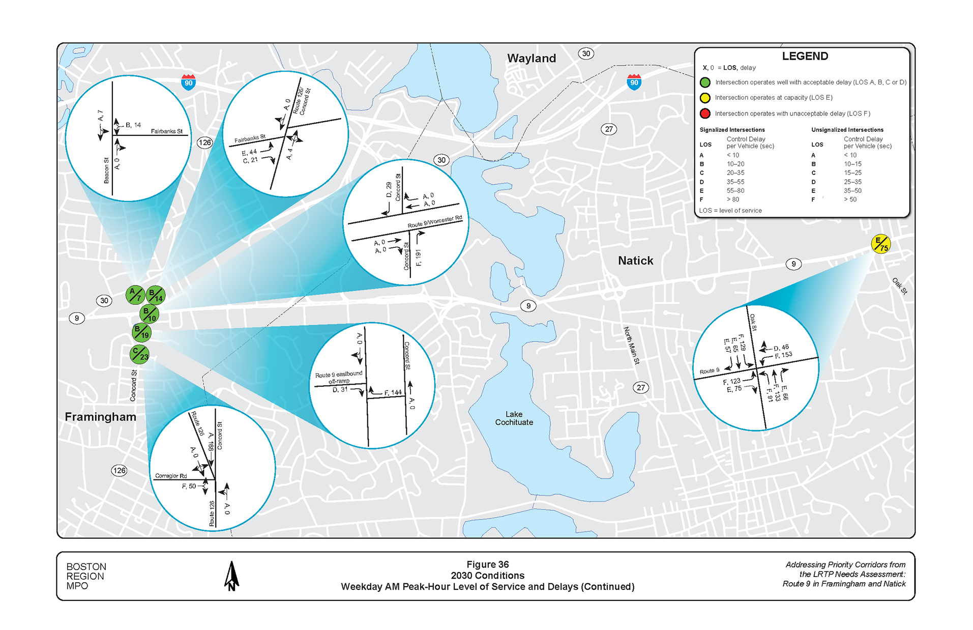
Figure 37
2030 Conditions: Weekday PM Peak-Hour Level of Service and Delays

Each of the proposed improvements was chosen to target specific safety and operational deficiencies present in the study area. Due to limited financial resources available to implement highway safety improvements, it is important that safety improvements return the highest level of benefits. A primary benefit of safety improvements is to reduce injury crashes and fatalities, so it is useful for road owners to understand how much a particular safety improvement, or set of safety improvements, can reduce crashes. A crash modification factor is a multiplicative factor used to compute the expected number of crashes after implementing a given countermeasure at a specific site. These estimates have been developed by comparing crashes before implementation of a safety improvement against crashes after implementation.
The improvements developed in this study provide Massachusetts Department of Transportation (MassDOT), the City of Framingham, the Town of Natick, and other stakeholders an opportunity to review options for addressing deficiencies in the corridor before committing design and engineering funds to a roadway improvement project. If implemented, the improvements would support economic vitality, increase travel choices in the corridor, and make it safer for people who walk, bicycle, drive, and ride the bus.
Project development is the process that takes transportation improvements from planning concept to construction. Successful implementation of the improvements would require cooperation among MassDOT Highway Division, the City of Framingham, and the Town of Natick. The study provides the necessary information for the project proponents to initiate the project notification and review process. After completing these initial steps, the proponents can start preliminary design and engineering and begin working with the Metropolitan Planning Organization to program funding for the project in the Transportation Improvement Program. Appendix F contains an overview of the project development process.
1 An HSIP crash cluster is a location in which the number and severity of crashes—as measured on the Equivalent Property Damage Only (EPDO) index—ranks the location among the top five percent of crash clusters in the region. The EPDO method assigns weighted values to each crash based on whether the crash resulted in property damage (unweighted), injury (weighted by five), or a fatality (weighted by 10).
2 Boston Region Metropolitan Planning Organization, Destination 2040: The New Long-Range Transportation Plan of the Boston Region Metropolitan Planning Organization, endorsed by the Boston Region MPO on August 29, 2019.
3 Boston Region Metropolitan Planning Organization, Unified Planning Work Program, FFY 2021, endorsed by the Boston Region Metropolitan Planning Organization on July 16, 2020.
4 Safety Conditions: The location has a higher-than-average crash rate for its functional class; contains a crash cluster that makes it eligible for HSIP funding; contains a crash location on MassDOT Highway Division’s Top High Crash Locations Report; or has a significant number of pedestrian and bicycle crashes (two or more per mile).
5 Congested Conditions: The travel time index is at least 1.3. The travel time index is the ratio of the peak-period travel time to the free-flow travel time.
6 Multimodal Significance: The roadway carries one or more bus routes or is adjacent to a transit stop or station; the roadway supports bicycle or pedestrian activities or there is a project planned that will support these activities; there is a need to accommodate people who walk and bicycle and improve transit on the roadway; or there is a significant amount of truck traffic on the roadway serving regional commerce.
7 Regional Significance: The roadway is on the National Highway System; carries a significant portion of regional traffic (average daily traffic of 20,000 vehicles or more); lies within 0.5 miles of environmental-justice transportation analysis areas or zones; or is essential for the region’s economic, cultural, or recreational development.
8 Regional Equity: To ensure that, over time, all subregions in the MPO’s planning area receive support from the MPO in the form of UPWP planning studies, during each funding cycle, MPO staff select no more than one location per subregion to study and choose a location in a different subregion from the location studied in the preceding cycle.
9 Implementation Potential: The study location is proposed by the jurisdictional agency or agencies for the roadway; proposed or prioritized by a subregional group; or identified as a priority for improvement by other stakeholders.
10 Boston Region Metropolitan Planning Organization, Selection of FFY 2020 LRTP Priority Corridor Study Location, Technical Memorandum, November 7, 2019.
11 Ryan Hicks and Casey-Marie Claude, Pedestrian Level-of-Service Memorandum, Technical Memorandum to the Boston Region Metropolitan Planning Organization, January 19, 2017.
12 Transportation Research Board of the National Academies,Highway Capacity Manual, Sixth Edition: A Guide for Multimodal Mobility Analysis, Washington, DC, September 2020.
13 CUBIC, Trafficware Inc., Synchro plus SimTraffic, Version 11.1 Build 1 version 6 (11.1.1.6), Sugar Land, Texas.
14 Signal Phase and Timing (SPaT) message defines the current intersection signal light phases. The current state of all lanes at the intersection are provided, as well as any active preemption or priority.
15 SPaT Challenge is for state and local public sector transportation infrastructure owners and operators to achieve deployment of dedicated short-range communications (DSRC) 5.9 GHz infrastructure with SPaT broadcasts in at least one corridor or network (approximately 20 signalized intersections) in each of the 50 states by January 2020 through cooperation and coordination
16 DSRC refers to two-way radio communication operating on the 5.9GHz band for the purpose of supporting vehicle-to-vehicle and vehicle-to-infrastructure traffic applications.
17 US Department of Transportation Federal Highway Administration, Crash Modification Factors Clearinghouse, April 2022, Crash Modification Factors Clearinghouse (cmfclearinghouse.org)
18 P. Alluri, A. Raihan, D. Saha, et al. “Statewide Analysis of Bicycle Crashes.” Florida Department of Transportation (May 2017).