Memorandum
Date: December 19, 2013
To: Jean Delios, Community Services Director/Town Planner
Town of Reading
From: Mark Abbott, Senior Transportation Planner
MPO Staff
Re: Community Transportation Technical Assistance Program: Main Street (Route 28) from South Street to Washington Street, Reading
The Community Transportation Technical Assistance Program provides technical advice on local transportation issues to municipal officials. Staff members of the Boston Region Metropolitan Planning Organization (MPO) and Metropolitan Area Planning Council (MAPC) jointly assist with this program. This is one of five studies conducted in federal fiscal year (FFY) 2012-13 under this program. The five locations studied are in:
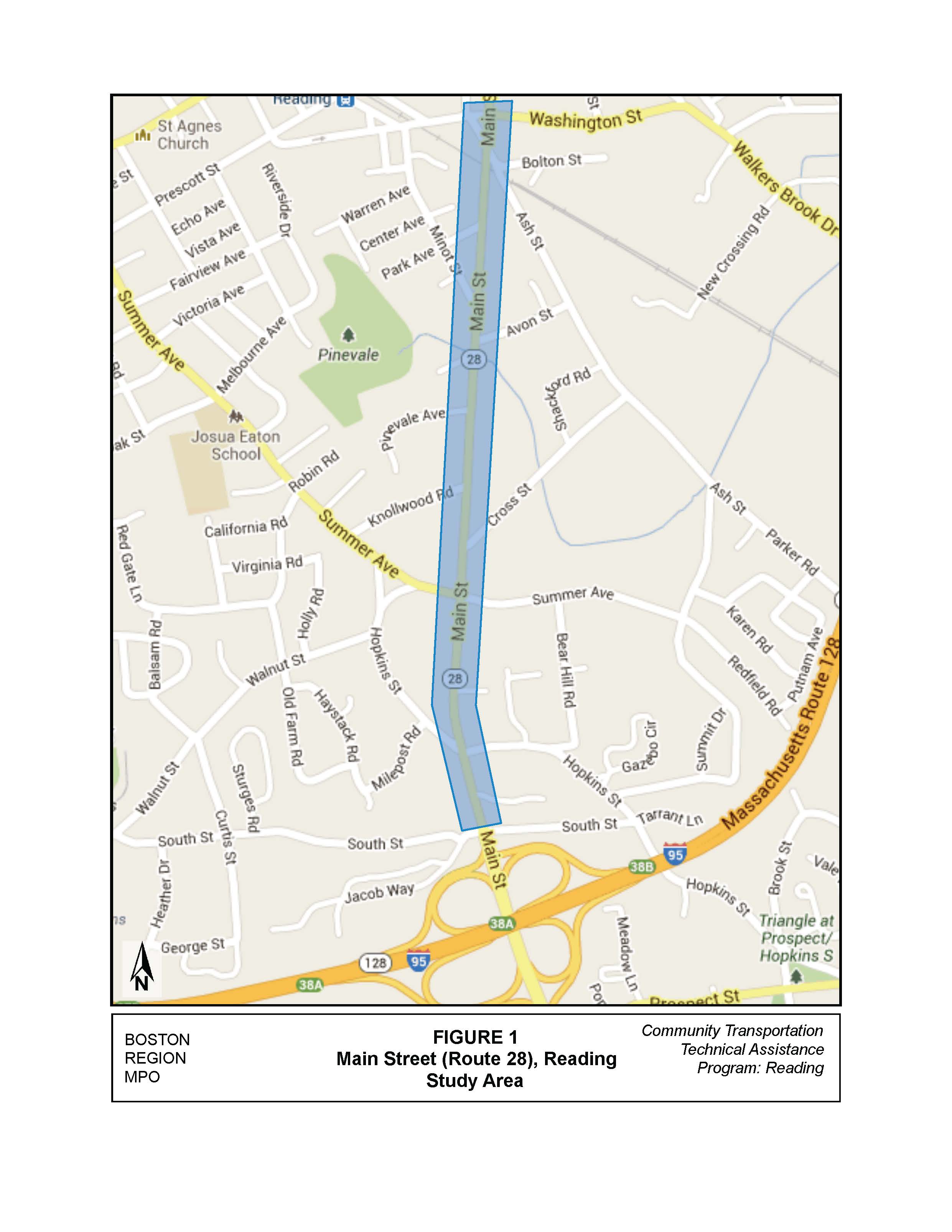
On request of the Town of Reading, Boston Region MPO staff examined an approximate 1.1-mile section of Main Street (Route 28) from South Street to the railroad crossing near Ash Street (shown in Figure 1).
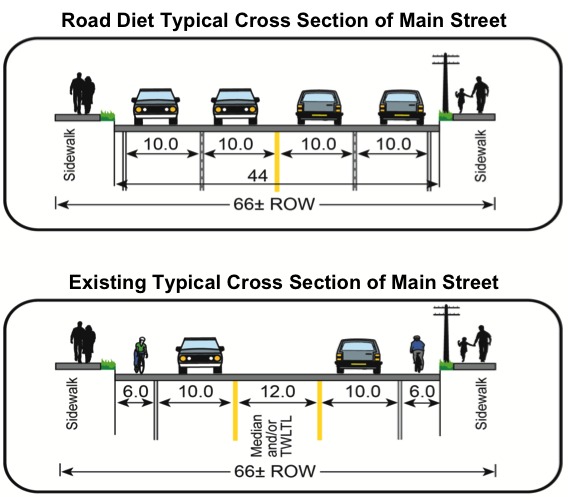
Reading would like to investigate the possibility of implementing a “road diet” along this section of Main Street, reducing the number of travel lanes to two (one in each direction). The Town’s reason for this roadway design modification is not only to improve traffic flow and safety for vehicles, but also to improve safety and accommodations for bicyclists and pedestrians.
exclusive left-turn lanes. The additional pavement provided by reducing the number of lanes can be used to provide several features, including:
The Federal Highway Administration (FHWA) has published that there are expected safety benefits associated with road diets: “When roadways are modified from four travel lanes to two travel lanes with a two-way left-turn lane, roadways have experienced a 29 percent reduction in all roadway crashes. The benefits to pedestrians include reduced crossing distance and fewer midblock crossing locations, which account for more than 70 percent of pedestrian fatalities.”1
FHWA also provides a reference threshold for the Average Daily Traffic (ADT) for which road diets could be considered, and states that: “Roadways with ADT of 20,000 or less may be good candidates for a road diet. Also, roadways with 15,000 ADT or less had very good results in the areas of safety, operations, and livability”.
In addition, road diets have multiple safety and operational benefits for vehicles as well as pedestrians, such as:
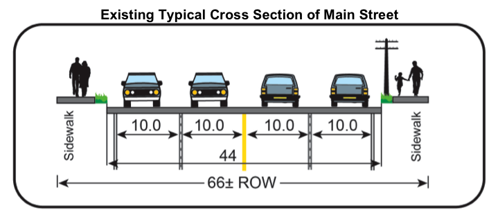
 This 1.1-mile section of Main Street (Route 28) from South Street to the railroad crossing near Ash Street is orientated in a north/south direction. Its functional classification is “urban principal arterial,” according to the MassDOT Office of Transportation Planning. This section of roadway is under the jurisdiction of MassDOT and is four lanes wide with a two-foot shoulder in both the northbound and southbound directions. Sidewalks, whose widths vary between five and eight feet, exist along both sides of the roadway.
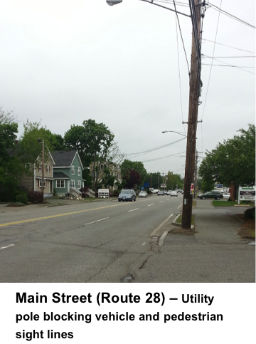
Also located along the eastern side of the roadway are utility poles that impact the usable sidewalk widths and sight lines along the roadway.
A typical roadway section for Main Street is shown below.
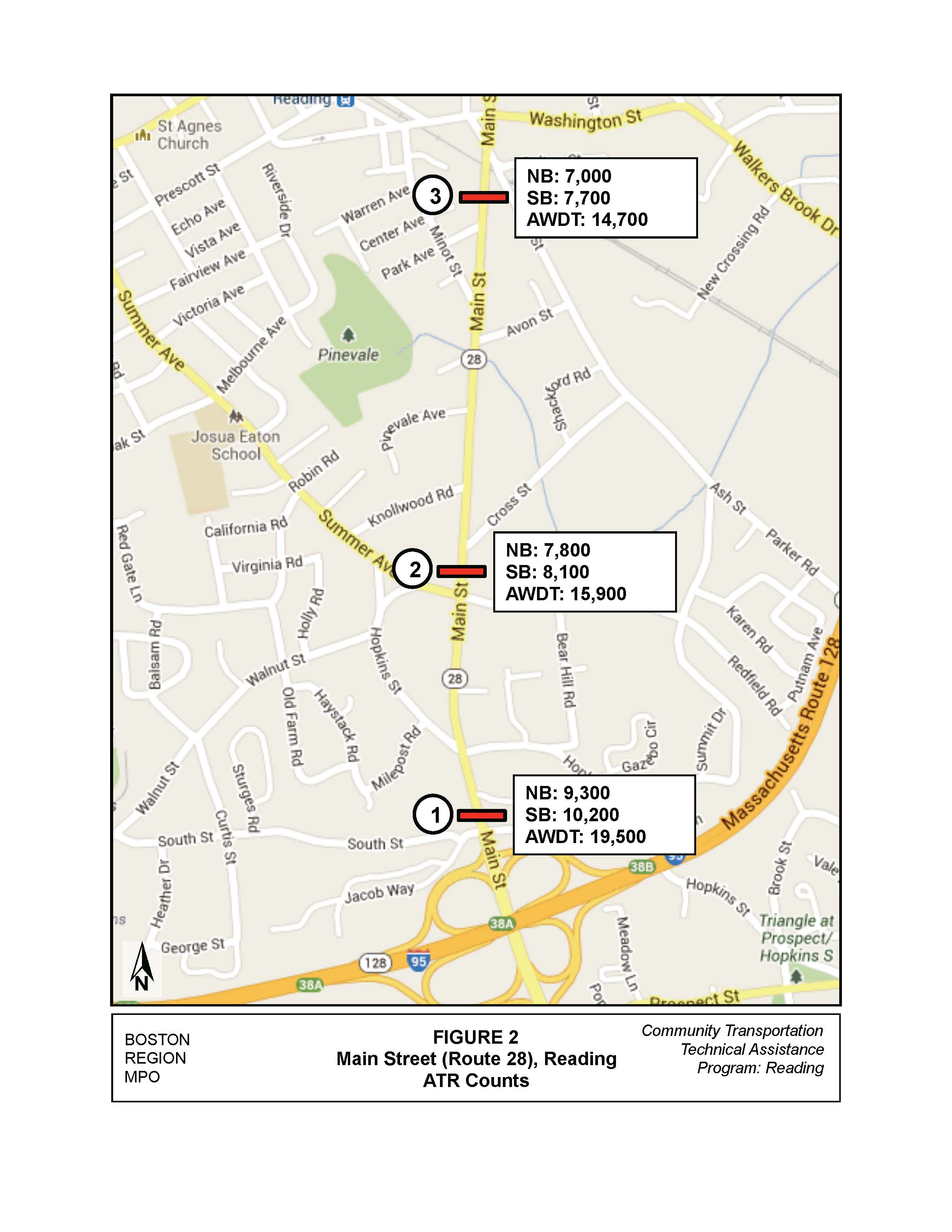
During the week of June 10, 2013, MassDOT collected traffic volumes along the corridor. . Automatic Traffic Recorder (ATR) counts were conducted at three locations along the corridor, as shown in Figure 2.
As mentioned previously, roadways with ADT of 20,000 vehicles per day or less may be good candidates for a road diet, and roadways with an ADT of 15,000 vehicles per day or less have very good results in terms of safety, operations, and livability. Therefore, based on the ADT counts conducted for this study, the roadway near the first and second count locations are good candidates for a road diet; and the roadway near the third count location should have very good results, if a road diet is implemented according to the FHWA publication.
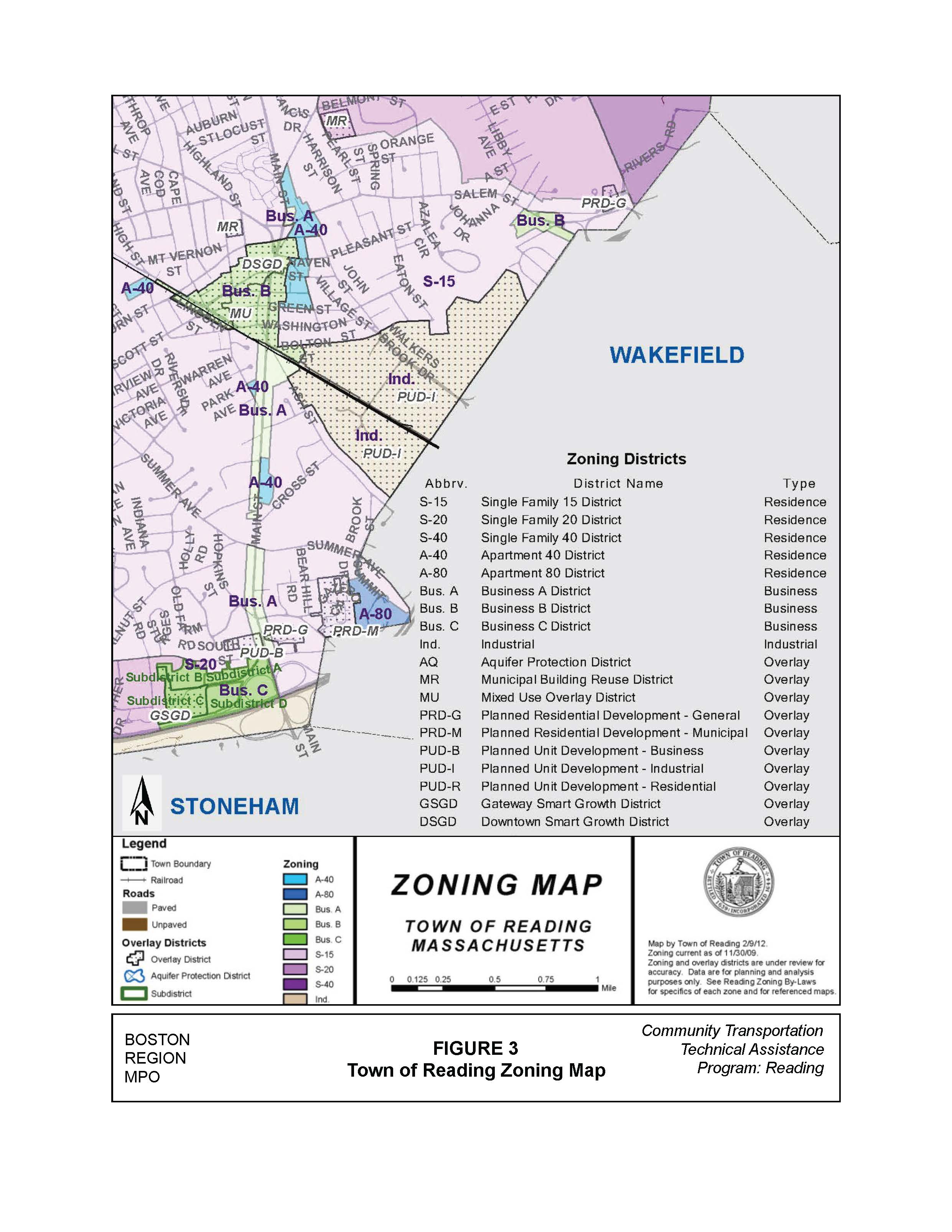
The land use adjacent to Main Street is primarily business and commercial, with some residential usage along the corridor. This section of Main Street lies within Reading’s Business A District, as shown in Figure 3. Business A District can include, but is not limited to, residential, school, church, business, service, and automotive usage. There are also two Apartment District 40 areas located in this section of corridor; and Business C District is located to the southwest of the Main Street and South Street intersection.
For the purpose of this study, the corridor was divided into three segments (from south to north), listed below. Staff reviewed each of the segments qualitatively to assess the potential for implementing a road diet.
This section of the corridor is approximately 680 feet long and lies between the signalized intersection of Main Street and South Street and the unsignalized intersection of Main Street and Hopkins Street, as shown in Figure 4.
The South Street intersection is signalized and located approximately 120 feet north of the ramps to and from I-95 southbound. This four-way intersection provides access to new developments located west of the intersection on South Street and a residential area east of the intersection. The Main Street approaches have two general-purpose lanes, and the South Street approaches have one general-purpose lane. The signal heads are mounted on a span wire.
The Hopkins Street intersection is an unsignalized, four-way skewed intersection, which is under study by MassDOT for possible reconstruction to install a traffic signal. In addition, MassDOT conducted a Road Safety Audit (RSA)2 of this intersection on April 9, 2013, which cited the following potential safety enhancements:
The adjacent land use along both sides of Main Street is commercial. Along the eastern side of Main Street there are five driveways to businesses, all of which allow left and right turns into and out of them. The western side of Main Street has seven driveways.
This segment of Main Street had a total of six crashes (not including crashes at either intersection) over a five-year period based on MassDOT crash data from 2007 to 2011. (Crash summary is shown in Table A1 in the Appendix.) The number of crashes seems to be under reported, which could be because the segment is short and crashes were reported as part of the intersections. To verify this, crashes at both intersections were checked and it was found that the South Street intersection had 20 crashes and the Hopkins Street intersection had 38 crashes.
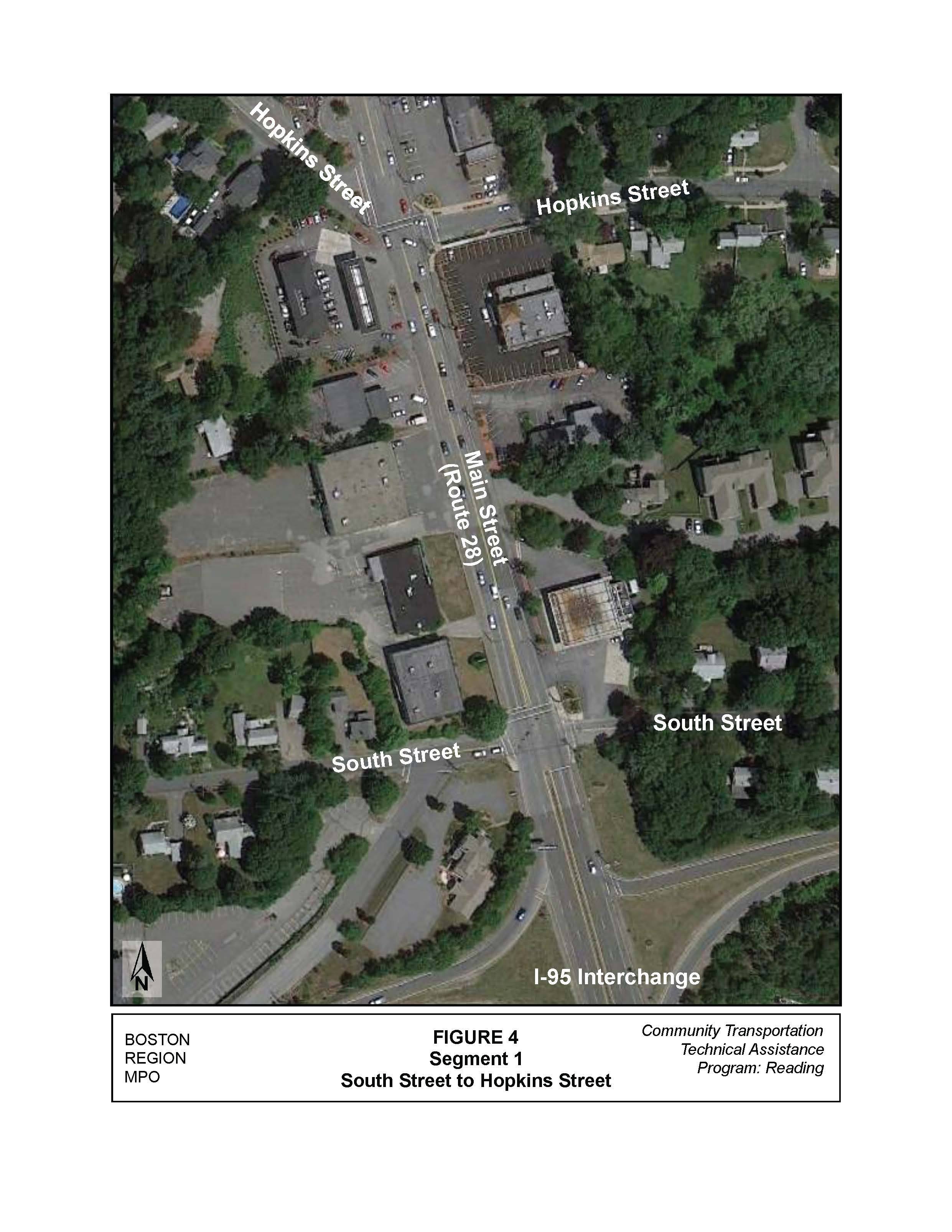
Based on the ADT volumes for this segment (19,500 vehicles per day, with 9,300 vehicles traveling in the northbound direction and 10,200 vehicles traveling in the southbound direction) a road diet could be implemented here, but one must consider future traffic growth as well.
Although this segment may qualify for a road diet at present, MPO staff does not recommend implementing such a treatment. The ADT traffic volume is at the upper limit recommended by the FHWA and future traffic growth could push traffic volume to levels where the treatment is deemed inefficient. Also, because the segment is so short in length—thus hard for a center two-way left-turn lane to operate efficiently—it would require the center two-way left-turn lane to be implemented along the entire segment. This would reduce the intersection capacity at both intersections, which in turn could impact the I-95 interchange and make accessing adjacent businesses more difficult.
This section of the corridor is approximately 1,200 feet long and lies between the unsignalized intersection of Main Street and Hopkins Street and the signalized intersection of Main Street and Summer Avenue, as shown in Figure 5.
The Summer Avenue intersection is signalized four ways, and provides access to residential areas east and west of the intersection. The Main Street approaches have two general-purpose lanes, and the Summer Avenue approaches have one general-purpose lane. The signal heads are mounted on a combination of mast arms and signal posts.
The adjacent land use along both sides of Main Street is mainly commercial. However, there appear to be some residences along the eastern side of Main Street closer to Summer Avenue; also on the eastern side of Main Street are nine driveways to businesses and residences, all of which allow left and right turns into and out of the driveways. The western side of Main Street has ten driveways.
This segment of Main Street had a total of 22 crashes (not including crashes at either intersection) over a five-year period based on MassDOT crash data from 2007 to 2011. (Crash summary is shown in Table A2 in the Appendix.) During this time, fifty percent of the crashes were either sides-wipe or rear-end collisions. As previously mentioned, road diets have the potential to reduce these types of crashes.
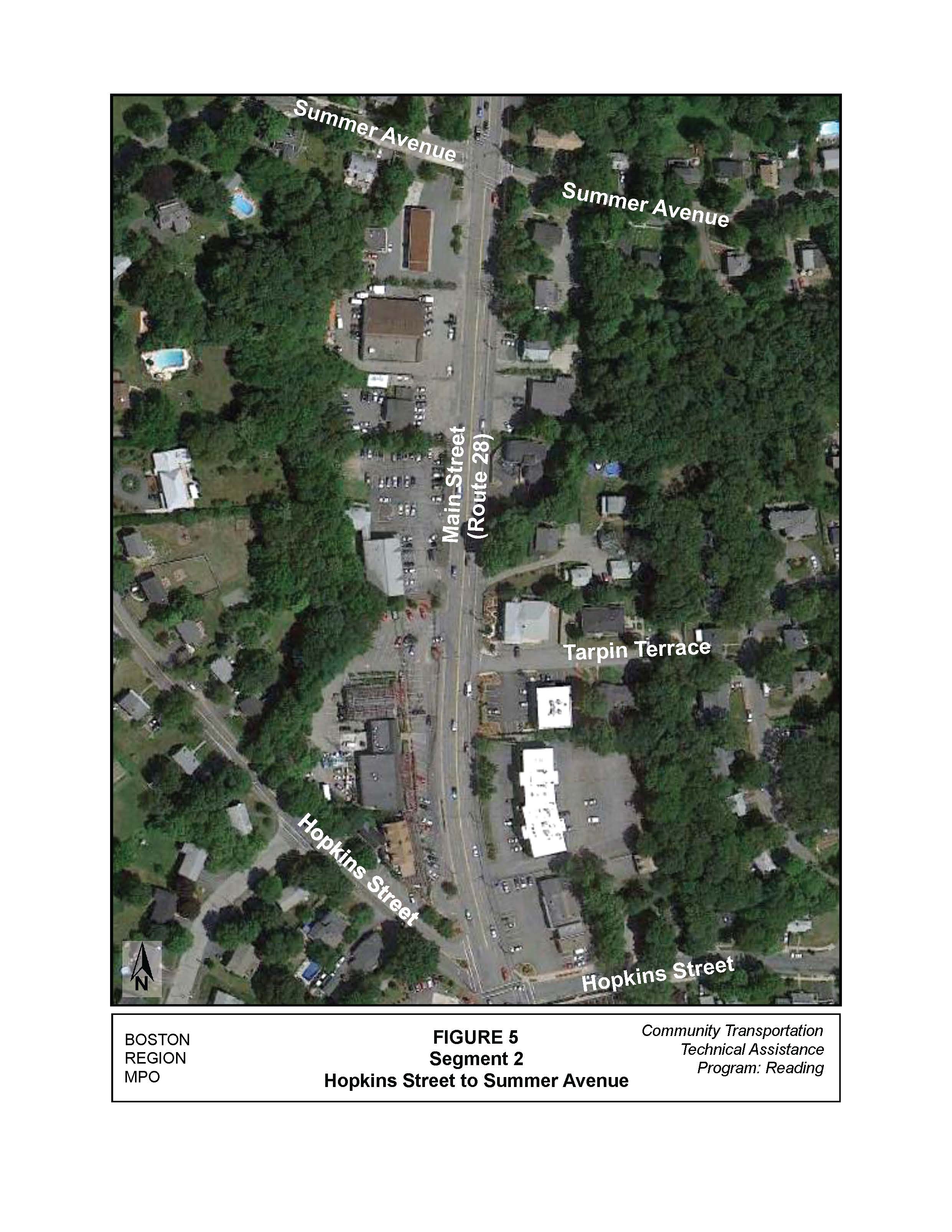
Based on this segment’s ADT volumes, which transition from 19,500 vehicles per day to 15,900 vehicles per day, a road diet could be implemented here, which would help reduce the number of crashes.
The road diet should transition to the reduced travel lanes north of Hopkins Street and extend through the Summer Avenue intersection. In this segment, a two-way left-turn lane should be implemented to allow access to the adjacent properties. A center median could not be implemented because of the inability to provide for U-turns at either the Hopkins Street or Summer Avenue intersections.
At the Summer Avenue intersection, the two-way left-turn lane should transition to a dedicated left-turn lane for the Main Street approaches to the intersection. Preliminary analysis indicates that the intersection would operate at acceptable levels of service during both peak hours with the reduction to one through lane and one left-turn-only lane on Main Street.
With the road diet and implementation of the two-way left-turn lane, safety should be improved with the reduction in side-swipe and rear-end crashes.
This section of the corridor is the longest of the three segments, at approximately 3,350 feet in length, and it extends from the signalized Summer Avenue intersection to the railroad crossing near Ash Street as shown in Figure 6.
The adjacent land use along the eastern side of Main Street, for approximately first third of the segment (from south to north), is primarily residential with both single-family houses and condominiums. Then, as one approaches the center of town, the land usage transitions to commercial properties. Between the residential and commercial driveways there are approximately 26 driveway openings. On the western side of Main Street, for approximately 500 feet (south to north), the land use is primarily residential, and then transitions to commercial with some residential properties mixed in. There are approximately 29 driveway openings on the western side of Main Street. This segment of Main Street had a total of 64 crashes (not including crashes at either intersection) over a five-year period based on MassDOT crash data from 2007 to 2011. (Crash summary is shown in Table A2 in the Appendix.) During this time, 44 percent of the crashes were either side-swipe or rear-end crashes. As previously mentioned, road diets can be effective in reducing these types of crashes.
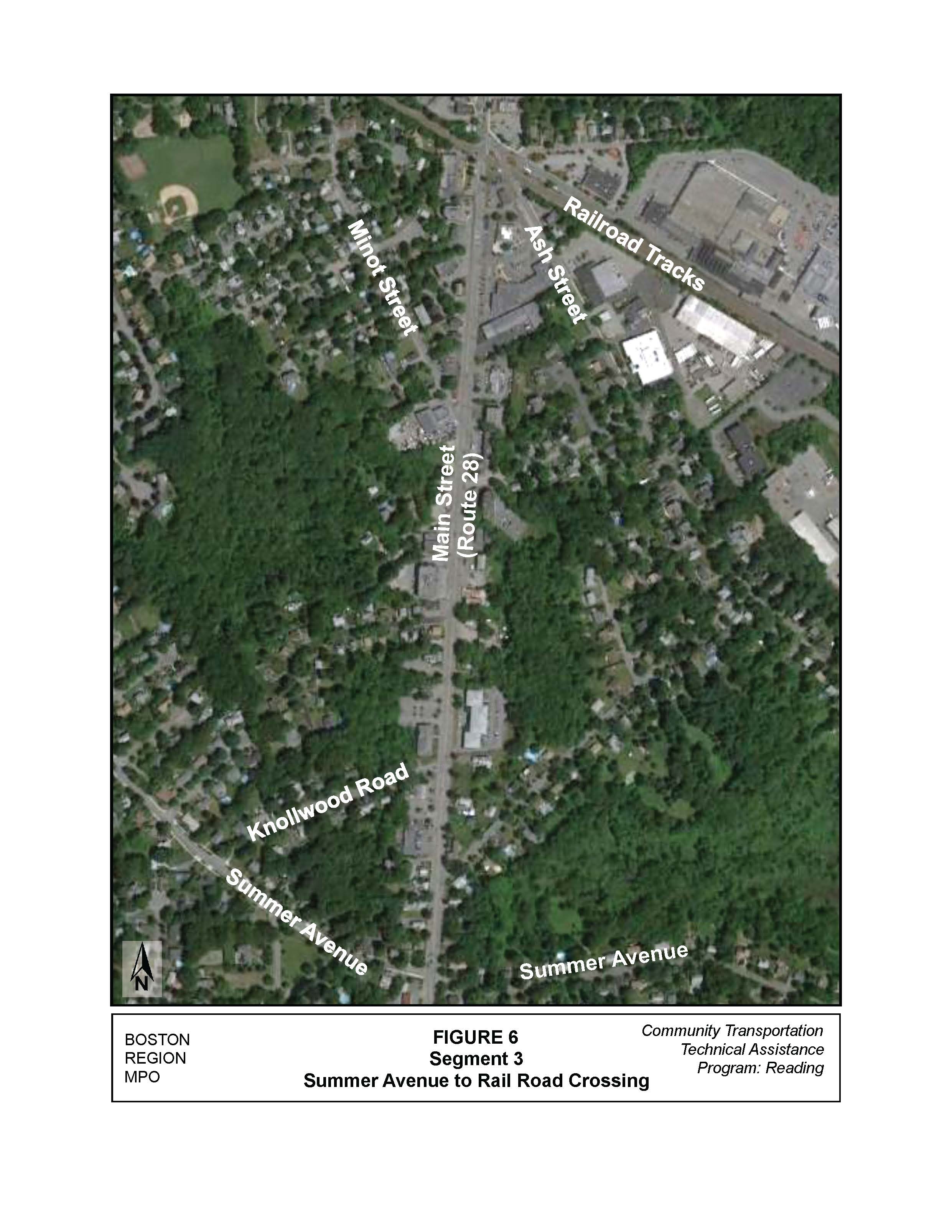
Based on the ADT volumes for this segment, which are 14,700 vehicles per day, a road diet could be implemented here. The road diet would transition back to a center two-way left-turn lane from the dedicated left-turn lane at Summer Avenue, which would allow for the continued access to all properties. Again, a center median could not be implemented here because of the inability to provide for U-turns.
With the road diet and the implementation of the two-way left-turn lane, safety should be improved with the reduction in side-swipe and rear-end crashes.
The town of Reading requested that this section of Main Street be examined in order to evaluate whether a road diet could be implemented to improve safety and provide better bicycle and pedestrian accommodations. MPO staff found that a road diet could be implemented on a majority of this section of Main Street. Below are the findings of the evaluation:
MSA/msa
Appendix A
Crash Summary Tables
Table A1
Segment 1: South Street Hopkins Street—Crash Summary
|
2007 |
2008 |
2009 |
2010 |
2011 |
Total |
Average |
|
Total Crashes |
2 |
0 |
1 |
2 |
1 |
6 |
1.2 |
|
Crash Severity |
Property damage Only |
2 |
0 |
1 |
2 |
1 |
6 |
1.2 |
Personal injury |
0 |
0 |
0 |
0 |
0 |
0 |
0 |
|
|
Fatality |
0 |
0 |
0 |
0 |
0 |
0 |
0 |
Collision Type |
Not reported |
0 |
0 |
0 |
0 |
0 |
0 |
0 |
Angle |
0 |
0 |
1 |
1 |
0 |
2 |
0.4 |
|
Rear-end |
1 |
0 |
0 |
0 |
0 |
1 |
0.2 |
|
Side-swipe |
1 |
0 |
0 |
0 |
1 |
2 |
0.4 |
|
Head-on |
0 |
0 |
0 |
0 |
0 |
0 |
0 |
|
|
Single vehicle |
0 |
0 |
0 |
1 |
0 |
1 |
0.2 |
Roadway Conditions |
Not reported |
0 |
0 |
0 |
0 |
0 |
0 |
0 |
|
Wet or icy pavement |
0 |
0 |
0 |
1 |
0 |
1 |
0.2 |
Weather Conditions |
Dark/lighted |
1 |
0 |
1 |
0 |
0 |
2 |
0.4 |
Clear |
1 |
0 |
0 |
1 |
1 |
3 |
0.6 |
|
Cloudy |
1 |
0 |
1 |
0 |
0 |
2 |
0.4 |
|
Rain |
0 |
0 |
0 |
1 |
0 |
1 |
0.2 |
|
|
Snow |
0 |
0 |
0 |
0 |
0 |
0 |
0 |
Crashes during weekday peak periods* |
|
1 |
0 |
1 |
1 |
0 |
3 |
0.6 |
Crashes involving pedestrian(s) |
|
0 |
0 |
0 |
1 |
0 |
1 |
0.2 |
Crashes involving bicyclist(s) |
|
0 |
0 |
0 |
0 |
0 |
0 |
0 |
* Peak periods are defined as 7:00–10:00 AM and 3:30–6:30 PM.
Table A2
Segment 2: Hopkins Street to Summer Avenue—Crash Summary
|
2007 |
2008 |
2009 |
2010 |
2011 |
Total |
Average |
|
Total Crashes |
6 |
5 |
1 |
7 |
3 |
22 |
4.4 |
|
Crash Severity |
Property damage Only |
4 |
3 |
1 |
4 |
2 |
14 |
2.8 |
Personal injury |
2 |
0 |
0 |
3 |
1 |
6 |
1.2 |
|
|
Fatality |
0 |
1 |
0 |
0 |
0 |
1 |
0.2 |
Collision Type |
Not reported |
0 |
0 |
0 |
0 |
0 |
0 |
0 |
Angle |
3 |
0 |
1 |
0 |
2 |
6 |
1.2 |
|
Rear-end |
2 |
3 |
0 |
2 |
1 |
8 |
1.6 |
|
Side-swipe |
1 |
0 |
0 |
2 |
0 |
3 |
0.6 |
|
Head-on |
0 |
0 |
0 |
0 |
0 |
0 |
0 |
|
|
Single vehicle |
0 |
2 |
0 |
3 |
0 |
5 |
1.0 |
Roadway Conditions |
Not reported |
1 |
0 |
0 |
0 |
0 |
1 |
0.2 |
|
Wet or icy pavement |
0 |
0 |
1 |
2 |
1 |
4 |
0.8 |
Weather Conditions |
Dark/lighted |
0 |
1 |
0 |
3 |
1 |
5 |
1.0 |
Clear |
5 |
5 |
0 |
4 |
2 |
16 |
3.2 |
|
Cloudy |
1 |
0 |
0 |
0 |
0 |
1 |
0.2 |
|
Rain |
0 |
0 |
1 |
3 |
0 |
4 |
0.8 |
|
|
Snow |
0 |
0 |
0 |
0 |
1 |
1 |
0.2 |
Crashes during weekday peak periods* |
|
1 |
1 |
0 |
1 |
1 |
4 |
0.8 |
Crashes involving pedestrian(s) |
|
0 |
0 |
0 |
0 |
0 |
0 |
0 |
Crashes involving bicyclist(s) |
|
0 |
0 |
0 |
0 |
0 |
0 |
0 |
* Peak periods are defined as 7:00–10:00 AM and 3:30–6:30 PM.
Table A3
Segment 3: Summer Avenue to Ash Street—Crash Summary
|
|
2007 |
2008 |
2009 |
2010 |
2011 |
Total |
Average |
Total Crashes |
14 |
13 |
3 |
16 |
18 |
64 |
12.8 |
|
Crash Severity |
Property damage Only |
12 |
13 |
3 |
13 |
17 |
58 |
11.6 |
Personal injury |
2 |
0 |
0 |
3 |
1 |
6 |
1.2 |
|
|
Fatality |
0 |
0 |
0 |
0 |
0 |
0 |
0 |
Collision Type |
Not reported |
2 |
2 |
0 |
0 |
0 |
4 |
0.8 |
Angle |
3 |
4 |
1 |
6 |
7 |
21 |
4.2 |
|
Rear-end |
5 |
1 |
2 |
3 |
7 |
18 |
3.6 |
|
Side-swipe |
1 |
3 |
0 |
4 |
2 |
10 |
2.0 |
|
Head-on |
1 |
0 |
0 |
1 |
0 |
2 |
0.4 |
|
|
Single vehicle |
2 |
3 |
0 |
2 |
2 |
9 |
1.8 |
Roadway Conditions |
Not reported |
1 |
0 |
0 |
0 |
0 |
1 |
0.2 |
|
Wet or icy pavement |
4 |
3 |
1 |
4 |
4 |
16 |
3.2 |
Weather Conditions |
Dark/lighted |
3 |
1 |
0 |
2 |
1 |
7 |
1.4 |
Clear |
7 |
11 |
2 |
9 |
14 |
43 |
8.6 |
|
Cloudy |
2 |
0 |
1 |
3 |
1 |
7 |
1.4 |
|
Rain |
3 |
1 |
0 |
2 |
3 |
9 |
1.8 |
|
|
Snow |
1 |
0 |
0 |
2 |
0 |
3 |
0.6 |
Crashes during weekday peak periods* |
|
5 |
5 |
1 |
6 |
7 |
24 |
4.8 |
Crashes involving pedestrian(s) |
|
0 |
0 |
0 |
0 |
0 |
0 |
0 |
Crashes involving bicyclist(s) |
|
0 |
1 |
0 |
0 |
0 |
1 |
0.2 |
* Peak periods are defined as 7:00–10:00 AM and 3:30–6:30 PM.