
Extreme heat can make walking, biking, rolling, and waiting for transit uncomfortable, dangerous, or even life-threatening. The Boston Region MPO’s Neutralizing Onerous Heat Effects on Active Transportation (NO-HEAT) project helps communities better understand where heat and transportation intersect and how targeted cooling strategies can support safer, more resilient travel.
Through NO-HEAT, the project team developed high-resolution heat exposure data for the Boston region, created tools to help communities identify high-risk street segments, worked with municipal and advocacy partners to connect the data to local experience, and shared practices that can support future planning, design, and implementation.
Deliverables
The NO-HEAT project produced data, tools, and partnerships, as well as applied research to support heat resilience for people walking, biking, and rolling in the Boston region. Project accomplishments include the following:
- Created a high-resolution dataset that estimates how people experience heat outdoors on a hot summer day in the Boston region
- Developed a dashboard that shows heat exposure across the region and along the road network
- Worked with advocacy partners to conduct walk and bike audits in Chelsea, Everett, Framingham, and Revere on selected priority corridors chosen by the municipalities
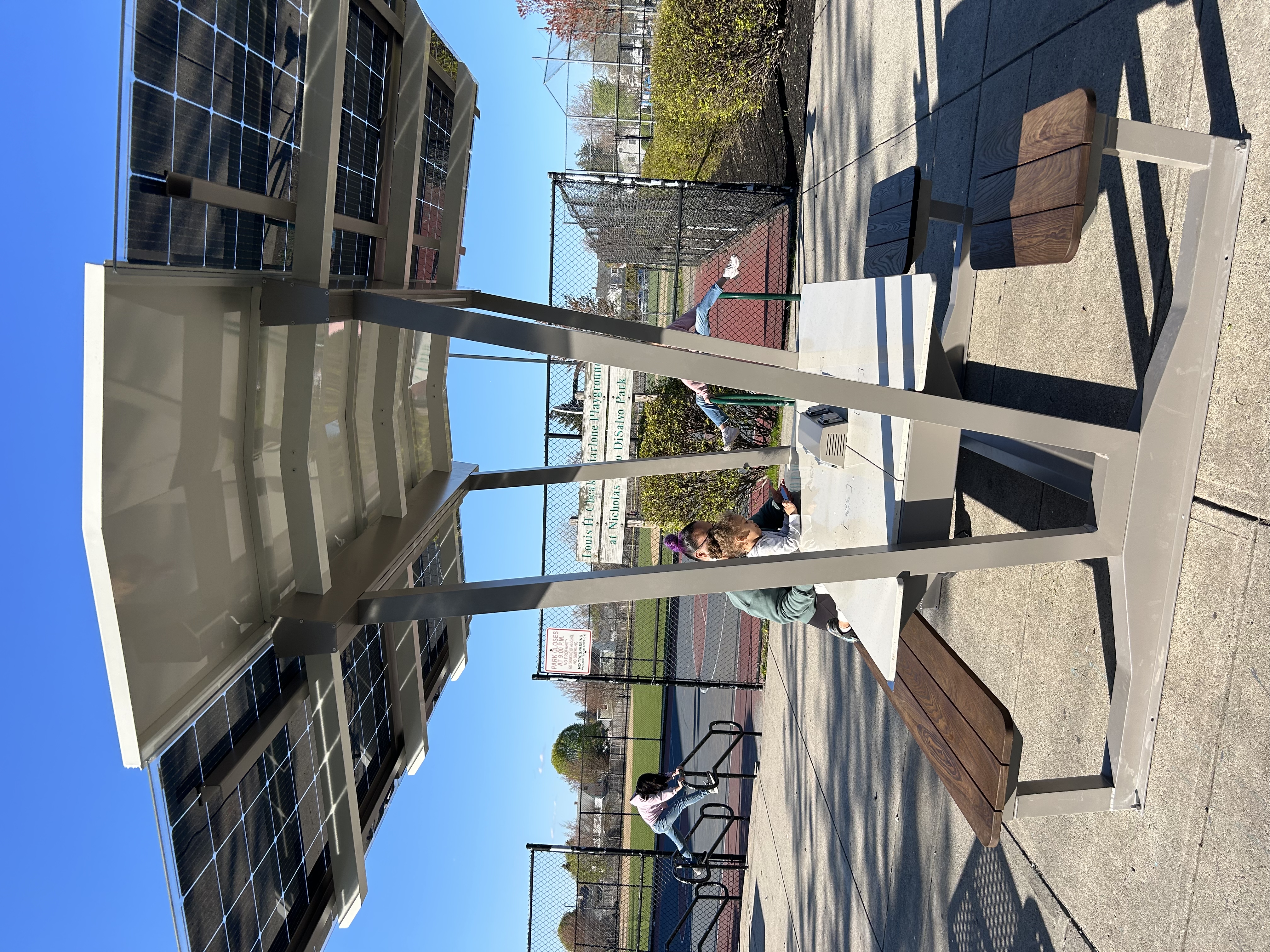
- Supported pilot urban heat relief installations, including shaded and solar benches at locations identified through the project’s data analysis and engagement feedback
- Hosted public webinars to explain the data, methods, dashboard, and tools developed through the project
Data and Dashboard
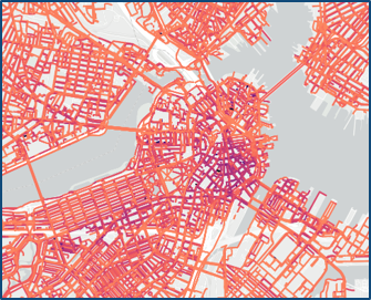
To better understand how people experience extreme heat, the project team created a dataset that estimates how it feels outdoors on a hot summer day in the Boston metropolitan region. These data are available at a one-meter resolution, which allows the project team to estimate how hot a person feels in the shade compared with a sun-exposed space just a few steps away. Because the Universal Thermal Climate Index (UTCI) dataset has a resolution of one square meter, it can help distinguish locations with dangerous heat exposure even on two sides of the same street. The project team also produced data for different times of day, allowing users to estimate heat stress at the hottest part of the day. This level of detail supports planning for more targeted heat mitigation strategies.
The dataset represents the UTCI, a measure of perceived thermal comfort that reflects how the human body experiences heat. UTCI incorporates environmental factors such as temperature, humidity, wind speed, shade, and the materials in the built environment, along with physiological factors. UTCI is expressed in degrees Celsius and is similar to a “feels like” temperature commonly shown in smartphone weather apps, but more accurately reflects how people experience heat differently across time and space.
The dashboard allows users to view the data in two ways. One view shows the UTCI temperature at every square meter in the Boston metropolitan region, excluding buildings. The other view shows UTCI mapped on the road network, showing how hot it feels for people traveling along each street or sidewalk.
Webinars
The NO-HEAT project team hosted two webinars to introduce the project’s data, methods, and tools.
Feeling the Heat, Part One: Where are the Hottest Street Segments in the Boston Region?
In this webinar, the project team presented the analysis behind the UTCI data created for the Boston region and discussed how communities within the Boston MPO region can use these data to identify heat risk in an area. This webinar is intended for municipal and community members who may be considering using the regional UTCI data in their communities.
Watch the recording of Part One on YouTube
Feeling the Heat, Part Two: Tools for Identifying the Hottest Street Segments in Your Community
In this webinar, the project team presented in detail the methodology used to develop the UTCI dataset and data required to calculate UTCI in a region. This webinar is aimed at both regional practitioners who want a deeper understanding of the data sources and methodology behind the regional UTCI dataset, and practitioners outside the Boston region who are interested in developing UTCI data for their own region.
Working with Municipal and Advocacy Partners
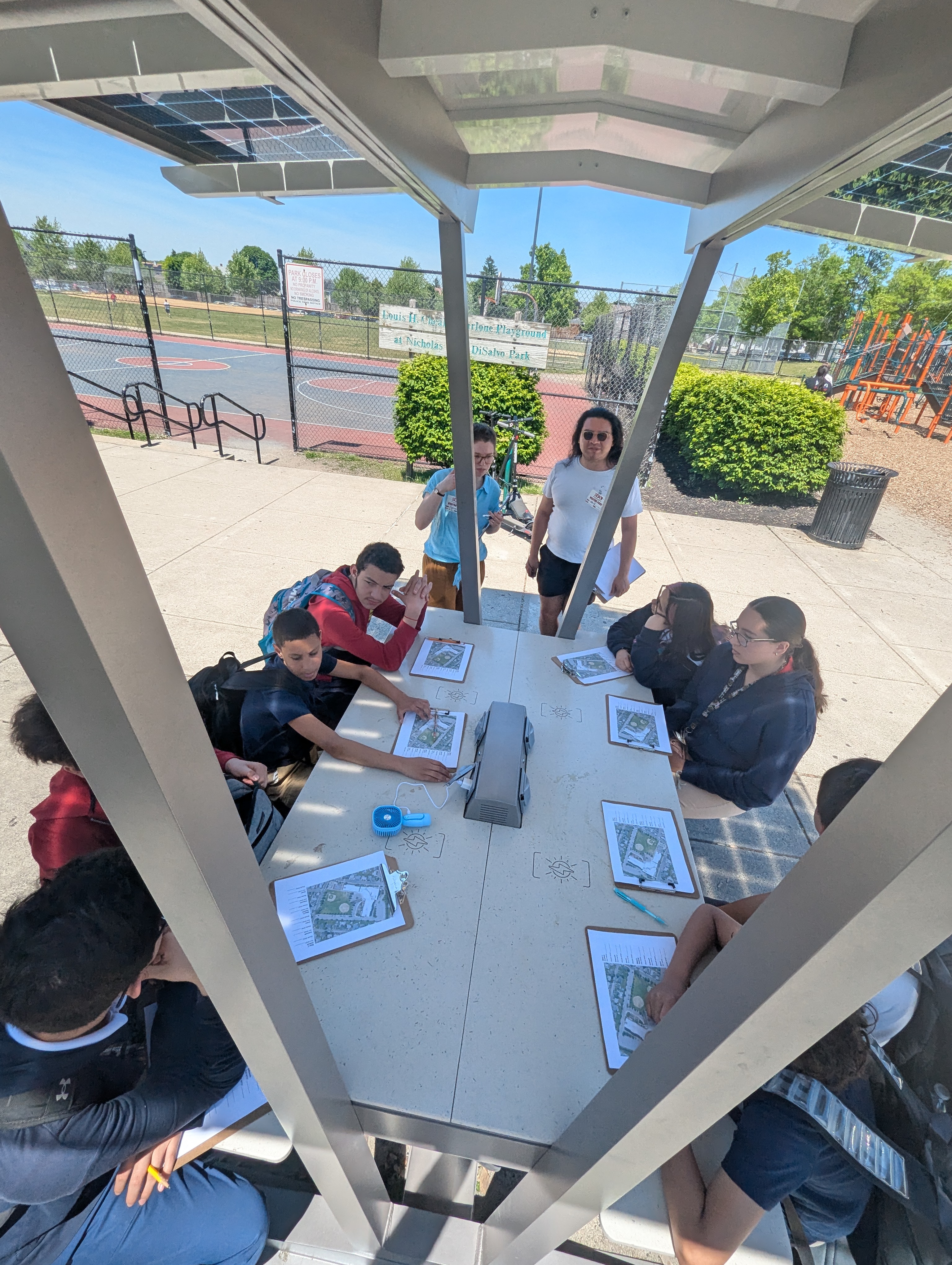
The NO-HEAT project was developed in collaboration with municipal and advocacy partners who helped connect regional data analysis to local conditions and community experience. Partner-led walk and bike audits helped the project team better understand how people experience heat while traveling along key routes. Data analysis was used to support pilot urban heat relief installations in Everett, Revere, and Chelsea. Installations included shaded benches along the Northern Strand Trail at 7-Acre Park in Everett, solar benches in DiSalvo Park in Revere, and at a bus stop on Everett and Carter Streets in Chelsea.
Project partners include the following:
- Georgia Institute of Technology (Research Partner)
- Cities of Chelsea, Everett, Revere, and Framingham (Municipal Partners)
- WalkMassachusetts, MassBike, Bike to the Sea, and Mystic River Watershed Association (Engagement Partners)
Funding and Project Background
The Boston Region MPO launched the NO-HEAT project with support from a Municipal Vulnerability Preparedness Action Grant from the Massachusetts Executive Office of Energy and Environmental Affairs. The grant funded work to integrate urban microclimate data with mobility data, identify communities and walking and biking routes most vulnerable to dangerous heat exposure, and work with local partners to explore cooling strategies that can make active transportation safer and more resilient to climate change.
The grant-funded phase of the project concluded in June 2026. The Boston Region MPO will continue to share the data, tools, and practices developed through NO-HEAT with municipal partners, peer agencies, funders, advocates, and others interested in advancing heat resilience and active transportation.
Learn More
- Press release on the 2024 Municipal Vulnerability Preparedness Grant Award
- June 2025 presentation from the Fostering Collaborations Symposium, hosted by the Metropolitan Area Planning Council and the Center for Climate and Health at Boston University School of Public Health, which aimed to foster constructive dialogue with a focus on bridging the gap between heat health research and practice: Slides 20–36 (PDF)
Contact
For questions about NO-HEAT, please email no-heat@ctps.org.